#BjnNowak
Explore tagged Tumblr posts
Photo

The surface area of the Antarctica compared to countries.
by BjnNowak
201 notes
·
View notes
Photo

Soil texture for contiguous USA.
by BjnNowak
313 notes
·
View notes
Photo

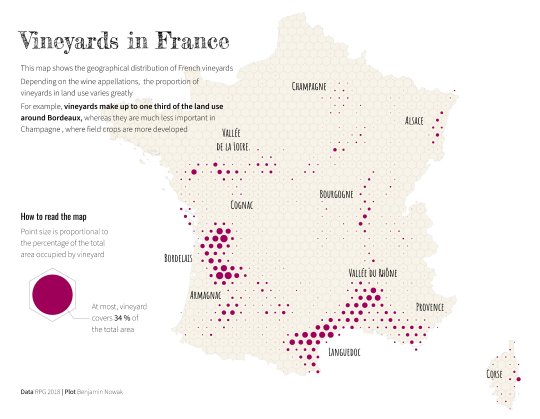
Vineyards in France.
by BjnNowak
101 notes
·
View notes
Photo

Who grows what?
by BjnNowak
101 notes
·
View notes
Photo

Green coffee beans and tea leaves exporters, 2020.
by BjnNowak
64 notes
·
View notes
Photo

GDP per capita by country.
A short thread showing the steps to create this simple map with rstats >>
by BjnNowak
59 notes
·
View notes
Photo

Who grows what?
Agricultural specialization of the different continents
by @BjnNowak
179 notes
·
View notes
Photo

Crop land or grass land?
This map compares the share of permanent grassland and arable land in the agricultural area of each country.
by BjnNowak
64 notes
·
View notes
Photo

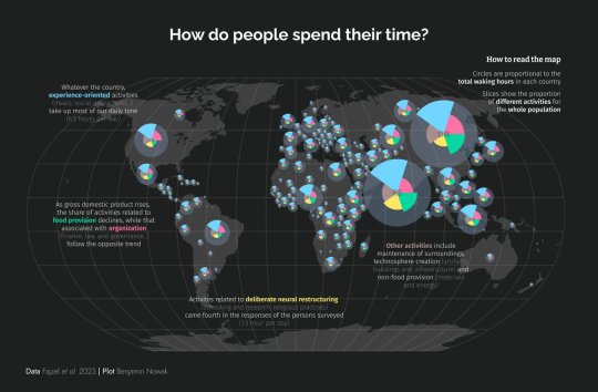
How do people spend their time?
by BjnNowak
47 notes
·
View notes
Photo

Energy production around the world. What is the share of fossil fuels, renewable energies or nuclear energy per country?
The size of the circles shows the total amount of energy produced per country since 2010. The color of the slices shows the origin of the energy (fossil, renewable or nuclear).
by BjnNowak
50 notes
·
View notes
Photo

Various degrees of urbanization between European countries
by @BjnNowak
110 notes
·
View notes
Photo

Our main activities are relatively similar between countries, with some differences depending on economic development (based on this week #TidyTuesday ) #RStats code:
by BjnNowak
60 notes
·
View notes
Photo

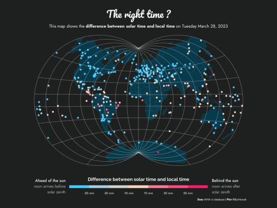
Local time of most countries is ahead of solar time (especially in the northern hemisphere). Countries behind the sun are mostly around the equator.
by @BjnNowak
113 notes
·
View notes
Photo

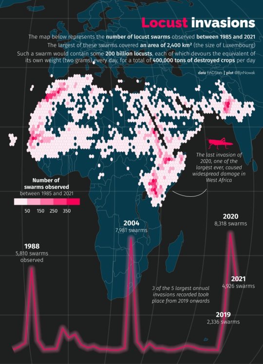
Geographic distribution of locust swarms that cause massive crop damage in Africa, especially in recent years.
by @BjnNowak
101 notes
·
View notes
Photo

Wheat distribution in France : soft winter wheat is by far the most cultivated crop in the country (mainly in the North, where yields are the highest)
by @BjnNowak
97 notes
·
View notes
Photo

Members of a sports association in France.
Percentage of the total population.
by BjnNowak
35 notes
·
View notes