#Basin Head Provincial Park
Explore tagged Tumblr posts
Text
Defiance
Bound and confined Behind a fence Of my own construction Bindings tied by my own hands Beyond Beyond Beyond the fence Barren sand But for one tough little plant Velvet leaves Belie the depths plumbed By roots anchoring it to Earth And if that little scrap of life Can defy the sand Then I, yes I Can defy this prison of mind Continue reading Defiance

View On WordPress
#Basin Head Provincial Park#beach#bound#Canada#defiance#fences#photography#postaday#Prince Edward Island#prison#recovery
0 notes
Text
Nova Scotia: North and West shores
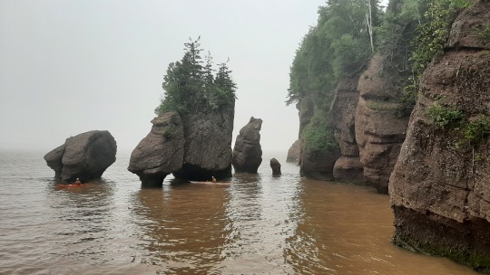
Before heading to Nova Scotia, I'm visiting the Hopewell Rocks which are at almost high tide this morning so that people kayak around the flowerpots rather than walk on the ocean floor. The Bay of Fundy is infamous for its fog so many viewpoints did not have much to show but the walk along the cliffs was still a great way to start the day!

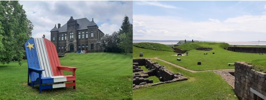
After having rounded the end of the bay through Moncton (which I visited a few years ago but didn't find interesting), I dove into Acadian history at the Monument-Lefebvre National Historic Site in Memramcook and at the Fort Beauséjour – Fort Cumberland National Historic Site. The first time I had heard about the Acadian people and their horrible deportation by the English had been in Cape Breton many years ago, so I knew their story but it was interesting to learn more... many of the original settlers came apparently from the area of La Rochelle in France, which is close to where my grandparents lived! The Lefebvre monument is at the first French college in the Maritimes, which allowed Acadians to get educated in their own language, which in turn spearheaded efforts to reclaim their identity. It was also the location of the first Acadian Convention in 1881, which continues to be held every 5 years celebrating Acadian culture across the world. Driving along Nova Scotia's north and west shores, the display of the Acadian flag everywhere shows that people remain proud to this day! 👌 The visit to the fort gave pretty views over the bay but also sobering thoughts as this was the site where the English deported many Acadians after having taken over the fort from the French (who had forced the Acadians to fight with them despite having proclaimed neutrality) ... It makes me shudder to be reminded time & time again of how brutal humans can be against each other!
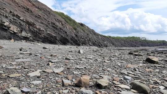
A completely different type of history is told at the Joggins Fossil Cliffs, which is a UNESCO world heritage site recognised for its preserved sequence of Carboniferous sediments and, due to the high tides continuously exposing more rock face, a tremendous collection of fossils from the Coal Age. Not only are there tons of fossilized trees (the 3 pics below are from left to right of the outer cast of a tree trunk, a tree root embedded in the rock, and a trunk that tumbled down from a rockslide), but it is here that a fossil was found of the first reptile which could reproduce on land and which therefore is the ancestor of all land-based animals, including the dinosaurs and ourselves 😃. A guided walk along the beach allowed us to pick up random rocks and ask whether it contained a fossil, and most of the time it did! 😁 It was a shame that we were not allowed to take anything home (I already have a little fossil collection from Oman), but that's what conservation is about.

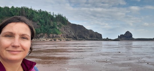
Final activity of the day is setting up my tent at Five Islands Provincial Park, close to the highest tides in the world (up to 16 meters!) in the Minas Basin, where I arrived at low tide so that I could walk over the seafloor to the first of the islands and have a look at the magnificent red cliffs (that don't contain any fossils). No single mosquito meant that I could watch the sun set over the bay in peace 😊. Next morning, the usual fog wasn't too bad so that I still had a bit of a view over the rocks from up high on a hiking trail.
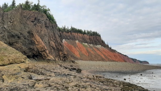

Driving around Minas Basin the next morning, I tried to see the tidal bore that happens when the high tide water rushes into a shallow river but missed it twice (at the first place in Truro I was an hour too early and at the next place along the Shubenacadie River it had just passed), but to watch the speed of the water coming in was impressive nevertheless (I had taken a video but sadly only one is allowed per post & I got a cooler one further down).
Having spent enough time on the high tides, I drove slightly more inland and had a great time wine tasting at Luckett Vineyards in the Annapolis Valley. Similar to around Niagara, this region has many different wineries who have tasting rooms, restaurants and little trails for visitors. The highlight here is the red telephone booth, from which you can call free to anywhere in North America, so I made a call to my colleague Kathryn who had recommended the place! 😍

Before leaving town, I also visited the Grand-Pré National Historic Site, which was the largest Acadian village before the deportation and where a statue of Evangeline graces the grounds in front of a memorial church. Evangeline was a fictious character from a poem that became to symbolize the Acadian plight so she's quite a heroine around here with streets, shops and everything in between named after her! The Celtic cross indicates the place where the villagers boarded the deportation ships before the town was burned down.

On that gloomy note, it started to rain and it didn't stop for two days 😒 the delicious chowder (seafood soup) at a harbour restaurant in Digby helped to warm up after which I was very happy having booked a hotel for 2 nights!
Despite the crappy weather I still had a great day at Digby Neck, which is a series of 2 islands jutting out into the Bay of Fundy, connected by two little ferries whose timetables are aligned so it's one drive through. I had however left an hour early so that I could hike to Balancing Rock on the first island, where a large piece of granite hangs precariously over the edge of the sea. It's a beautiful, rugged coastline and also the boardwalk to it (with big-leafed skunk cabbage around the trail) was pretty so well worth braving the rain!
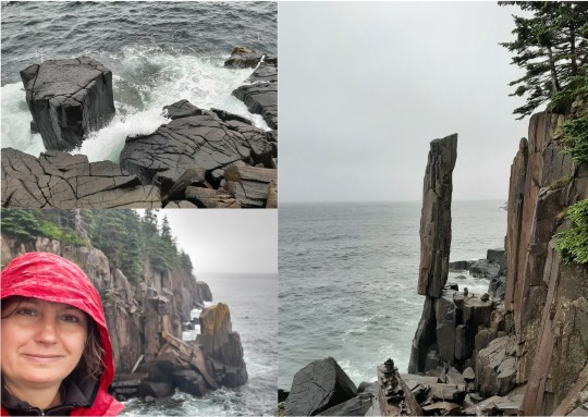
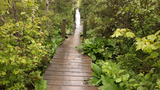
And then I had the most awful but also the coolest whale watching tour I've done so far... we spent about 3 hours off the coast of Brier Island in the driving rain on an open boat on a rolling sea looking for whales and seabirds... About a 1/3 of the tourists vomited and although I kept it in and was warm & semi-dry due to my many layers, it sucked!! There was nothing to see for a long long time apart from a few swimming seals and shearwater birds so the mood wasn't great, until two humpback whales called Foton and Litte Spot (according to the marine biologist) showed up right next to us!! They kept coming close to the boat and flapped their pectoral flipper on & on the water for some 20 minutes...something I've never seen before, really special! Swimming so close by, you could see their massive, grooved bodies and ofcourse their tails when they were diving deeper. On the way back, when the rain briefly stopped & the waves subdued closer to the shore, everyone was smiling 😃 however never been so happy to sit dry in my car waiting for the ferry ;)

The next day there was rain nor fog (woohoo!) so had a pretty drive along the west shore, where there's mostly small Acadian villages, the bigger town of Yarmouth where I got some beers from the local microbrewery and many, many lighthouses of which I chose three to visit. The first one was at Gilbert's Cove where you can walk up a ladder to stand next to the old light (now decommissioned). Outside, there were male eider ducks close by the shore so that you could see how truly large they are.

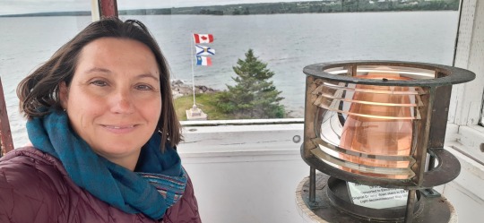
The second lighthouse I visited was at Cape Saint Mary, a tiny square (still active) building that you can't enter, but which has impressive rocks around it. Nearby Mavillete beach has pretty dunes and would be a great place to chill if it were warmer!

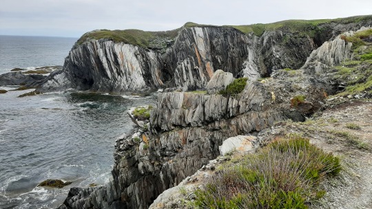
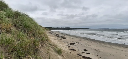

The third lighthouse that I saw is at Cape Forchu, southwest of Yarmouth, which is called the "apple core light" because of its shape. I can't imagine living on such an outcrop during a winter storm!

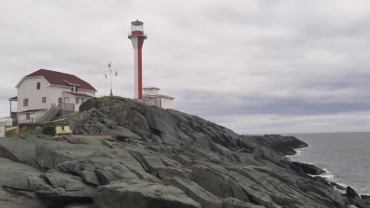
On the final stretch to my camp cabin for the night, I passed through badly burned forest west of Shelburne, which had been doused only the week prior... The fire had grown to more than 235 square kilometres and forced more than 6,000 people from their homes, destroying over 200 houses and other structures. It was very sad to see the "apple green" trees turned into all this black, stinking mess... That night, the smoke alarm in the cabin went off from time to time, which I was later told is due to remaining ash in the air.

Just before turning into the campground, I walked briefly around Shelburne's historic district, which was built largely by British Loyalists who fled from the US and started a new life here. It only being 4pm, the town was deserted apart from a few prom photo shoots which was funny to watch as they are still soooo young :)

Wildlife: 3 seals & 2 humpback whales (Digby Neck), 15 male Eider ducks. There's ofcourse also lots of shore birds all around the Maritimes, but whose name I don't know apart from gulls and cormorants which I'm not fond of, so ignoring those 😉
SUPs: none
Hikes: two at Five Islands PP, one at Digby Neck
7 notes
·
View notes
Text
Wow! September 1st! Can’t believe our adventure is almost over! Today we left camp and went to basin head beach provincial park to hear the singing sands! It was pretty cool and a nice beach! Then we made our way to the confederation bridge and came back into New Brunswick! We are camping at Murray beach provincial park tonight!
September 1, 2022


3 notes
·
View notes
Text
Nasutoceratops titusi
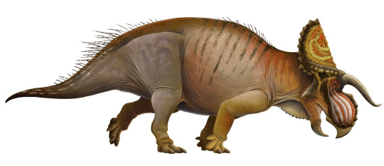
By Scott Reid
Etymology: Large-Nosed Horned-Face
First Described By: Sampson et al., 2013
Classification: Dinosauromorpha, Dinosauriformes, Dracohors, Dinosauria, Ornithischia, Genasauria, Neornithischia, Cerapoda, Marginocephalia, Ceratopsia, Neoceratopsia, Coronosauria, Ceratopsoidea, Ceratopsidae, Centrosaurinae, Nasutoceratopsini
Status: Extinct
Time and Place: Between 76 and 75.6 million years ago, in the Campanian age of the Late Cretaceous

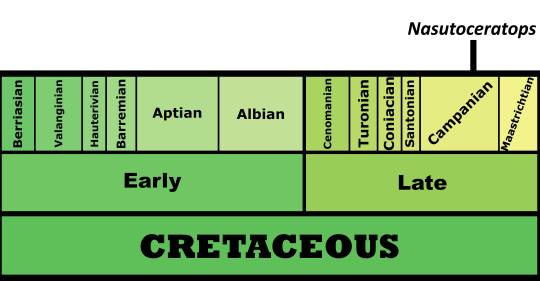
Nasutoceratops is known from the middle member of the Kaiparowits Formation in Utah
Physical Description: Nasutoceratops is a Ceratopsian - so, as with all Ceratopsians, it has an extremely distinctive head! Like other Ceratopsians, it would have been around 5 meters long or so, and had a very bulky body with a short, skinny tail. The legs of this dinosaur - as in others of its kind - were short, bulky, and had very padded and thick toes that made running easy for this animal. The really distinctive aspects of this dinosaur, however, were in its head - again, as in other Ceratopsians, which might as well all be Mr. Potato Heads with the different combinations of horns and frills as the exchangeable parts of the classic toy. Nasutaceratops sported a short frill, a short and high snout, and distinctively long horns. The horns on its brow were more horizontal than most, but they curved inward like those found on modern cattle! The nostril did not feature a horn, but was very high and ridged instead. Interestingly enough, there were extensive cavities in this rounded nose that may have been pneumatic, giving Nasutoceratops a very unique trait compared to other Ceratopsians. It had a very thickly overlapping upper jaw, which would have made it somewhat less flexible than other Ceratopsians. The frill had small round osteoderms all around the edge, and there isn’t a notch on the frill like in other Ceratopsians. As in its relatives, Nasutoceratops would have probably been primarily scaly, though it may have had feather-quills on the edge of its tail or elsewhere on its body. The frill would have probably been brightly colored, for display.
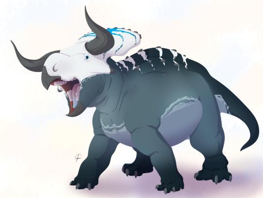
By José Carlos Cortés
Diet: Nasutoceratops would have primarily been an herbivore, feeding on low-lying and medium-level leaves and other plant material, all less than one meter tall.
Behavior: Nasutoceratops, like other Ceratopsians, would have been a very social creatures! These dinosaurs would have spent a lot of time together roaming their home in large herds, and used their frills and fancy horns to display to one another for communication and mating displays. This points back to their fairly complicated social groupings, where the young would have been protected by the adults from oncoming danger. The horns would have also been useful in telling apart Nasutaceratops from other dinosaurs that lived with it, such as the Chasmosaurine Ceratopsian Kosmoceratops. Like other dinosaurs, it would have been warm-blooded, and thus needed to spend a good chunk of the day finding food. It also may have fought with its horns, though that’s somewhat more controversial, especially given their odd shape - though a combination of the bumpy nose and horns . These horns may have had sheaths of fingernail material (keratin) over them, making them longer, but probably not more available for fighting. The colors of the frill may have been able to change, giving even more communication ability. These structures - the frills and horns - wouldn’t have been prominent in baby Nasutoceratops, but grew with the animal as it aged into sexual maturity. Nasutoceratops would have taken care of its young, which would eventually join the herd with the adults.
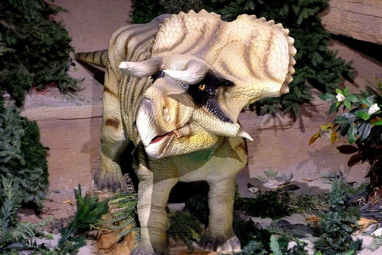
By Kathy Neenan, CC BY-SA 4.0
Ecosystem: Nasutoceratops lived in the Kaiparowits Formation, which would have been a very muddy jungle ecosystem, with a wide variety of animals living very near the Western Interior Seaway. A variety of swamps, ponds, and lakes frequented the entire area, which was surrounded on its other side by highlands and mountains, enclosing it against the sea. It was a very wet and humid environment, allowing for high animal diversity. Among those that lived with Nasutoceratops include other Ceratopsians like Kosmoceratops and Utahceratops, hadrosaurs like Gryposaurus and Parasaurolophus, the ankylosaur Akainacephalus, the Troodontid Talos, the Ornithomimid Ornithomimus, the Oviraptor Hagryphus, and the opposite bird Mirarce! That being said, the main predator of Nasutoceratops would definitely have been the local Tyrannosaur, Teratophoneus. There were also a variety of mammals, turtles, and Neosuchians in the environment, which all took advantage of the wet swampy conditions.
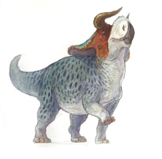
By Ripley Cook
Other: Nasutoceratops was a Centrosaurine, those Ceratopsians more closely related to the likes of Styracosaurus than to Triceratops. Interestingly enough, these Ceratopsians tend to do more weird stuff with their noses - usually giant horns, but Nasutoceratops seems to have gone for a more lightweight option. In fact, Nasutoceratops gave its name to a whole group of these animals, which retained the brow horns of the ancestral ceratopsians (where other Centrosaurines lost them).
~ By Meig Dickson
Sources Under the Cut
Atterholt, J.; J. Howard Hutchison; Jingmai K. O’Connor (2018). "The most complete enantiornithine from North America and a phylogenetic analysis of the Avisauridae". PeerJ. 6: e5910.
Chiba, K., M. J. Ryan, F. Fanti, M. A. Loewen. D. C. Evans. 2018. New material and systematic re-evaluation of Medusaceratops lokii (Dinosauria, Ceratopsidae) from the Judith River Formation (Campanian, Montana). Journal of Paleontology 92 (2): 272-288.
Eaton, Jeffrey G.; Cifelli, Richard L.; Hutchinson, J. Howard; Kirkland, James I.; Parrish, J. Michael (1999). "Cretaceous vertebrate faunas from the Kaiparowits Plateau, south-central Utah". In Gillete, David D. (ed.). Vertebrate Paleontology in Utah. Miscellaneous Publication 99-1. Salt Lake City: Utah Geological Survey. pp. 345–353.
Eaton, J.G., 2002. Multituberculate mammals from the Wahweap(Campanian, Aquilan) and Kaiparowits (Campanian, Judithian)formations, within and near Grand Staircase-Escalante NationalMonument, southern Utah. Miscellaneous Publication 02-4, UtahGeological Survey, 66 pp.
Fowler, D. W. 2017. Revised geochronology, correlation, and dinosaur stratigraphic ranges of the Santonian-Maastrichtian (Late Cretaceous) formations of the Western Interior of North America. PLoS ONE 12 (11): e0188426.
Getty, M. A., M. A. Loewen, E. M. Roberts, A. L. Titus, and S. D. Sampson. 2010. Taphonomy of horned dinosaurs (Ornithischia: Ceratopsidae) from the late Campanian Kaiparowits Formation, Grand Staircase-Escalante National Monument, Utah. In M. J. Ryan, B. J. Chinnery-Allgeier, D. A. Eberth (eds.), New Perspectives on Horned Dinosaurs: The Royal Tyrrell Museum Ceratopsian Symposium. Indiana University Press, Bloomington 478-494
Hone, D.W.E.; Naish, D.; Cuthill, I.C. (2011). “Does mutual sexual selection explain the evolution of head crests in pterosaurs and dinosaurs?” (PDF). Lethaia. 45 (2): 139–156.
Lund, E. K. (2010). "Nasutuceratops titusi, a new basal centrosaurine dinosaur (Ornithischia: Ceratopsidae) from the upper cretaceous Kaiparowits Formation, Southern Utah". Department of Geology and Geophysics University of Utah: 172 pp.
Mallon, Jordan C; David C Evans; Michael J Ryan; Jason S Anderson (2013). [tp://link.springer.com/article/10.1186/1472-6785-13-14 "Feeding height stratification among the herbivorous dinosaurs from the Dinosaur Park Formation (upper Campanian) of Alberta, Canada"]. BMC Ecology. 13: 14.
Roberts EM, Deino AL, Chan MA (2005) 40Ar/39Ar age of the Kaiparowits Formation, southern Utah, and correlation of contemporaneous Campanian strata and vertebrate faunas along the margin of the Western Interior Basin. Cretaceous Res 26: 307–318.
Roberts EM, Sampson SD, Deino AL, Bowring S, Buchwaldt R. The Kaiparowits Formation: a remarkable record of Late Cretaceous terrestrial environments, ecosystems and evolution in western North America. In: Titus AL, Loewen MA, editors. At the Top of the Grand Staircase: The Late Cretaceous of Southern Utah. Bloomington, Indiana: Indiana University Press; 2013. p. 85–106.
Ryan, M.J.; Holmes, R.; Mallon, J.; Loewen, M.; Evans, D.C. (2017). "A basal ceratopsid (Centrosaurinae: Nasutoceratopsini) from the Oldman Formation (Campanian) of Alberta, Canada". Canadian Journal of Earth Sciences. 54.
Sampson, S. D., 2001, Speculations on the socioecology of Ceratopsid dinosaurs (Orinthischia: Neoceratopsia): In: Mesozoic Vertebrate Life, edited by Tanke, D. H., and Carpenter, K., Indiana University Press, pp. 263–276.
Sampson, S. D., M. A. Loewen, A. A. Farke, E. M. Roberts, C. A. Forster, J. A. Smith, and A. L. Titus. 2010. New horned dinosaurs from Utah provide evidence for intracontinental dinosaur endemism. PLoS One 5(9):e12292:1-12.
Sampson, S. D.; Lund, E. K.; Loewen, M. A.; Farke, A. A.; Clayton, K. E. (2013). "A remarkable short-snouted horned dinosaur from the Late Cretaceous (late Campanian) of southern Laramidia". Proceedings of the Royal Society B: Biological Sciences. 280 (1766): 20131186.
Tanke, D.H. and Brett-Surman, M.K. 2001. Evidence of Hatchling and Nestling-Size Hadrosaurs (Reptilia:Ornithischia) from Dinosaur Provincial Park (Dinosaur Park Formation: Campanian), Alberta, Canada. pp. 206–218. In: Mesozoic Vertebrate Life—New Research Inspired by the Paleontology of Philip J. Currie. Edited by D.H. Tanke and K. Carpenter. Indiana University Press: Bloomington. xviii + 577 pp.
Titus, Alan L. and Mark A. Loewen (editors). At the Top of the Grand Staircase: The Late Cretaceous of Southern Utah. 2013. Indiana University Press. Hardbound: 634 pp.
Weishampel, David B.; Dodson, Peter; and Osmólska, Halszka (eds.): The Dinosauria, 2nd, Berkeley: University of California Press. 861 pp.
Wiersma, J. P.; Randall B. Irmis (2018). "A new southern Laramidian ankylosaurid, Akainacephalus johnsoni gen. et sp. nov., from the upper Campanian Kaiparowits Formation of southern Utah, USA". PeerJ. 6: e5016.
Zanno, Lindsay E.; Sampson, Scott D. (2005). "A new oviraptorosaur (Theropoda; Maniraptora) from the Late Cretaceous (Campanian) of Utah". Journal of Vertebrate Paleontology. 25 (4): 897–904.
Zanno, L.E., Weirsma, J.P., Loewen, M.A., Sampson, S.D. and Getty, M.A. (2010). A preliminary report on the theropod dinosaur fauna of the late Campanian Kaiparowits Formation, Grand Staircase-Escalante National Monument, Utah.[permanent dead link]" Learning from the Land Symposium: Geology and Paleontology. Washington, DC: Bureau of Land Management.
Zanno, L. E.; David J. Varricchio; Patrick M. O'Connor; Alan L. Titus; Michael J. Knell (2011). "A new troodontid theropod, Talos sampsoni gen. et sp. nov., from the Upper Cretaceous Western Interior Basin of North America". PLoS ONE. 6 (9): e24487.
#Nasutoceratops titusi#Nasutoceratops#Dinosaur#Ceratopsian#Palaeoblr#Factfile#Prehistoric Life#Mesozoic Monday#Herbivore#North America#Cretaceous#Paleontology#Prehistory#Dinosaurs#Dinosaur of the day#A Dinosaur A Day#A-Dinosaur-A-Day#Dinosaur-of-the-Day#nature#biology#science
313 notes
·
View notes
Photo

So,
Until I moved to the Kootenays in 2014, I’d never been politically engaged enough to be able to make an informed vote at the municipal level. Politically I had UVic-style leftward leanings, but that didn’t mean I understood the implications of the sort of decisions a city’s mayor and council would make. What did I know about bylaws? Or taxes? I thought it was stupid that we had to buy stickers to put on our garbage bags, but beyond that I didn’t have any pressing concerns about how they were running things down at Nelson city hall.
With the election coming up, I knew I had to wrap my head around the various issues in the city and how they related to the people we were voting into power. The mental health crisis was going to be a talking point, I knew from Police Chief Wayne Holland, and there was talk the dog bylaw might finally be overturned. The most interesting element to me was weed legalization and its implications. The hottest topic was affordable housing. When Calvin assigned me to interview all of the city council and mayoral candidates, at first I felt daunted by the scope of the project — more than 10 interviews and thousands of words over the course of a few weeks. I realized pretty quick, though, it was my opportunity to deep-dive into this shit.
If I was going to be a real journalist, I would have to get into politics.
Greg was on the city hall beat at that point, and anytime Tamara, Calvin or I had a question about the election or the people involved, it was him we went to. Some of the candidates Greg knew from growing up in the area, others from covering them in previous elections, but there was nobody he couldn’t give us a multi-year rundown on. He would swivel in his chair and gesticulate with one scholarly finger in the air, opining in his radio announcer voice. The longer I worked alongside him the more I admired his encyclopedic knowledge, how relentless he was about pursuing the truth, sometimes scouring through old archives to better understand a crime that happened 100 years before he was born and other times harassing clerks to get damning documents on criminals still working their way through the court system. He was the Star’s greatest asset, and everybody understood that.
One afternoon I sat in the newsroom with Greg and talked about the elections of the past and how they influenced the one coming up. He told me Phil McMillan, the compassion club director, had run for mayor on a cannabis slate around ten years previous. And a local actor named Richard Rowberry had campaigned as the ghost of Nelson’s first mayor, John “Truth” Houston. One former mayor he spoke about with affection was Dave Elliot, who was remembered mostly in town for stopping an expansion of the local Walmart. The executives were in back-room negotiations to double the store’s size into the next lot when Elliot broke confidentiality and raised the alarm with the community. Ultimately he purchased the neighbouring land, along with a number of other Nelson families, just to stop the deal from going ahead. The property had been sitting vacant ever since — a visual testament to the Kootenay spirit of opposing development. A number of projects had tried to get off the ground there, including a condo complex, but the math just didn’t seem to be right. It was prime lakeside property, fenced off, the yard full of abandoned machines, broken concrete and waist-high grass.
Depending on who you asked, it was this move that got ultimately got Elliot ousted. Some felt he over-stepped. The right-wing types felt he was too hippy dippy, and wanted someone who would champion the small businesses on Baker Street with more diligence. Dooley was a reliably conservative city councillor at this point, and ended up taking the big seat in 2005. By the time I showed up in the Kootenays he was the longest serving Nelson mayor in history.
According to Greg, Dooley was hyper-popular and heavily favoured to win. But there were murmurings in the community about dissatisfaction. He seemed like a perfect Irish gentleman to me, polite and amiable, but apparently some felt he was a a bully in the council chambers — as evidenced by the signs stapled to telephone poles around town that read ‘Bully for Mayor’. That being said, he had a number of impressive accomplishments under his belt and had proven himself adept at finding new revenue streams for the community, whether it was from the provincial and federal governments or from organizations like the Columbia Basin Trust. Many credited his contribution for making the new skate park possible. No matter what anyone said, they couldn’t question that he loved his community deeply, and wanted to create a better future for its residents.
*
Then there were the cops.
“What are they going to do about that cop that punched the woman? That’s what I want to know,” Paisley asked one evening, while I was watching TV. She had come up with a plan, along with her new burlesque friends, to hold a topless protest outside the NPD station.
She carefully poured vegan muffin batter in to a baking sheet.
“I can’t believe we’ve got a proven woman-puncher just working away at the police station like nothing happened. That fucker needs to be fired.”
“He still might be. Depends on how things go with the trial.”
“What’s left to know? Didn’t he admit doing it?”
That situation was an ongoing black eye for the NPD, and they were also under scrutiny because they were requesting a $300,000 boost to their budget. Another smouldering question was how they would deal with the end of cannabis prohibition. They were still busting people routinely, whether it was for grow-ops or possession, and residents wanted to know when that would change. The new mayor would be head of the Nelson Police Board, giving them power over Holland and his force, so this was an opportunity for pot advocates to land an ally in a strategic spot. Dooley was openly hostile to cannabis, and had gone on record a few years previous vehemently opposing an anti-violence initiative related to pot decriminalization, so he clearly wasn’t the right champion. That’s why a new provincial organization called Sensible BC, represented by pot activist Dana Larsen, announced its intentions to get involved in an attempt to eject him.
They wanted someone pot-friendly running the province’s weed capital.
One afternoon I met the local Sensible BC representative, Herb Couch, who was perfectly named for his position. He wanted to see less money wasted policing cannabis, and announced his intention to quiz each candidate on their stance and instruct his followers to vote accordingly. Couch had the backing of Phil McMillan and over 1000 dispensary members, so his influence wouldn’t be insignificant. He was a chill, soft-spoken former high school teacher sporting a signature cowboy hat and a vibrant orange shirt. Relentless about his activism, to the point of annoying some, he’d also been a vocal advocate for the preservation of Red Sands Beach.
I liked him right away.
“Sharon wants to know why we’re writing so many stories about pot,” Calvin said, after the interview with Couch ran. “I don’t think she’s a fan of this Herb character.”
“So many stories? We’ve just done the one.”
“Well, and it’s come up as a topic in some of the other stories about the election. The candidate profiles, a few of them had whole sections about their views on weed.”
“So what’s the problem?”
“She says this isn’t even a relevant municipal issue. Legalization is a federal issue.”
“Right, but it has municipal implications.”
“Like what?”
“Well, like it will affect the police budget. How’s that not relevant?”
“Let’s just cool if with all the weed stuff, okay? People want to know about their taxes, about affordable housing, about all kinds of other stuff. This whole election can’t just be about marijuana.”
*
The moment Severyn announced his candidacy, the campaigning got ugly. Late-night vandals drove all around multiple neighbourhoods to collect his lawn signs, which featured cartoon moustaches, and dump them outside of town. He showed up at the Star office distraught, frustrated that his comrades in the police department weren’t doing more to figure out who the culprits were. (“You know how much those things cost? And that comes right out of my pocket,” Severyn lamented.) He made totally inappropriate accusations about Dooley, yelling in our foyer, and the rhetoric continued to devolve from there. It was clear to even the casual observer that the two men absolutely hated each other.
Dooley was furious that Severyn would even consider running against him, and more furious that the political dunce seemed to have hundreds of voters’ worth of support. He took it as a personal insult. During campaign events Dooley barely contained his frustration. I watched him repeatedly lose his cool.
Into this mix came Deb Kozak. Sporting a tidy grey bob and a simple pearl necklace, she had a sing-song friendliness to her voice and a fierce determination in her eyes. She’d been on council with Dooley and, though she wouldn’t say it directly, clearly had issues with his leadership. Observers believed she would’ve never been able to take Dooley on in a two-way race, but with Severyn as a wild card she stood a chance to take a strategic majority. If successful, she would be the first female elected mayor in history — a feat fellow councillor Donna Macdonald had tried and failed to accomplish twice. Deb had a maternal energy, and a general optimism about bringing people together and accomplishing positive things. It was a hopeful time in politics, with Obama in power down in the U.S., and I believed things were trending upwards. Culturally we were evolving, and our leadership reflected that, right down to the municipal level. By the end of our first interview it was clear she had my vote, whether I could admit it openly or not.
She seemed audacious.
“One thing I’ve learned as a councillor, and even before that, is I’m good at conversation. And I’m good at welcoming even difficult conversations. We have a diverse community, and sometimes that leads to conflict. I think you work through those things, and you make better decisions when all those groups are pulled together, or at least have an opportunity to share what they think about the future,” she said.
Kozak had arrived in Nelson in the 80s, just after David Thompson University and the Kootenay Forest Products plant shut down. The economic downturn was in full swing, and she’d been inspired by the ambitious moves made by the council at the time. They set out to give the downtown core a makeover, making it more attractive to tourists.
“It was a very frightening time. But it was at that time that the council of the day took a bold step forward to rejuvenate Baker. They said ‘we’re going to rip off all the old clapboards off these beautiful buildings and we’re going to go for it,” she said.
She wanted to be similarly ambitious.
“I bring to the table experience, passion, heart and mind. What I have to offer is almost fearless exploration of who we can be.”
The Kootenay Goon
1 note
·
View note
Text

Basin Head Provincial Park, Prince Edward Island — Took the free ferry over to PEI. We’re exploring the east side first. First stop was Cape Bear lighthouse which received the Titanics first distress call in Canada. Had a drive through Georgetown and Montague but neither had much going on to hold us so we headed to the Basin Head Provincial Park famed for its “singing sand beach.” With such a lovely view of the sea we stayed for the night.


0 notes
Photo
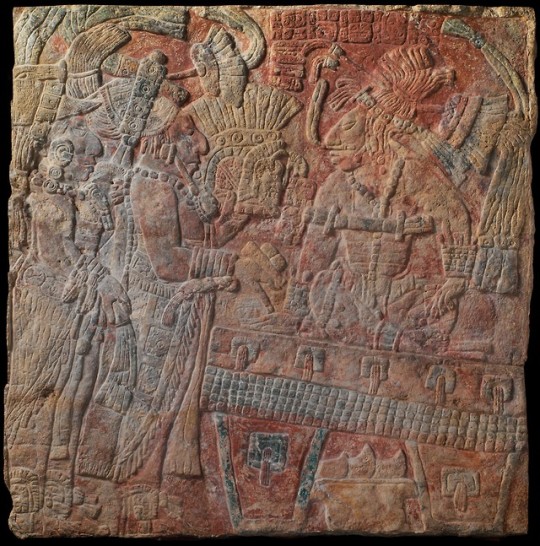
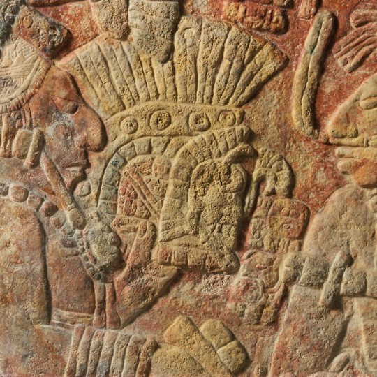
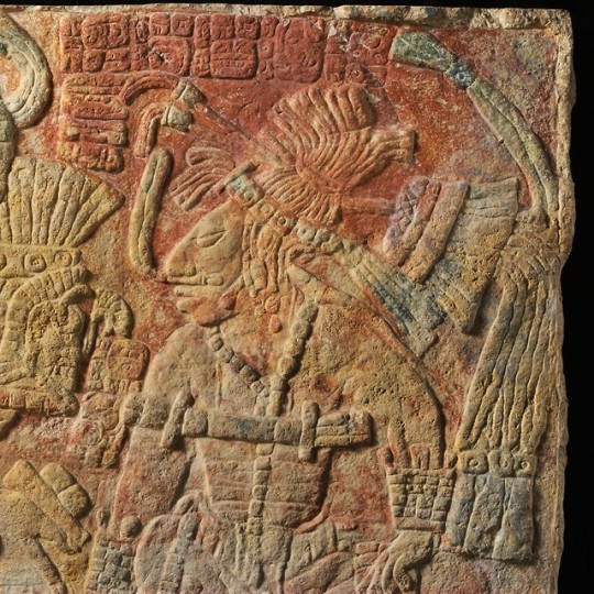
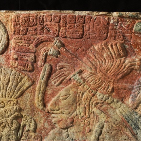
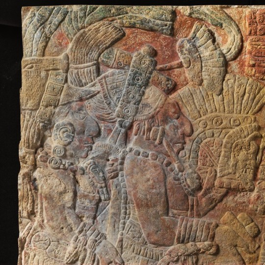
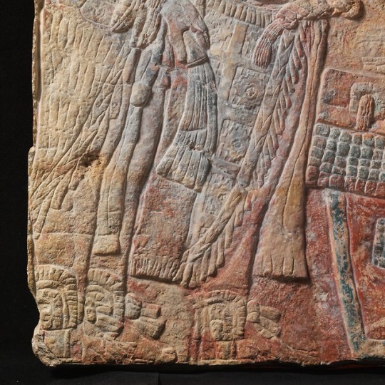
Relief with Enthroned Ruler
Artist: Chakalte' (Guatemalan or Mexican, active ca. A.D. 750–800)
Date: late 8th century
Geography: Guatemala or Mexico, La Pasadita
Culture: Maya
This Maya landmark was likely the carved lintel of a doorway from the site of La Pasadita in northwestern Guatemala carved in the early A.D. 770s. The relief panel would have been installed parallel to the floor of the entrance of a temple at La Pasadita. Visitors to the building were thus forced to look upward to view the monument, and perhaps even had to light the surface with raking torchlight in order to read the image and the text. The Metropolitan lintel is striking for the amount of pigment preserved on the surface. A variety of red, yellow-orange, and blue-green pigment remains to give clues about the original brightly colored appearance of the lintels. The jade jewels of the main characters and the details on the ruler’s throne glisten in blue-green, a color that symbolized the ‘first/newest’ and most precious materials. In the 8th century, the small hilltop site La Pasadita was caught between the power struggles of the self-proclaimed divine kings of the river kingdoms of Yaxchilan (modern-day Chiapas, Mexico), and Piedras Negras (Guatemala). During the Classic Maya period (ca. A.D. 250-900), the two major royal courts vied for power, paid tribute to one another, intermarried, and engaged in conflict with subsidiary local lords. Loyalties sometimes shifted, boundaries between the two city-states were often fortified, and artistic programs sponsored by the lords and ladies served as propaganda to stake claims on the contested landscape. The Yaxchilan kings and queens favored elaborate sculpted doorway lintels at the royal capital, and they made sure their local allies marked their palaces in the same way. At least a dozen related lintel reliefs are known from subsidiary sites around Yaxchilan. Likely commissioned by the Yaxchilan rulers themselves, most show the ruler from Yaxchilan in the company of the local lord in a supporting role in some ritual, making an overt statement of political sovereignty. The Met’s lintel depicts three protagonists: the figure seated on the right is faced by two standing ones to the left. The main figure offering an elaborate headdress to the seated leader is the La Pasadita ruler named Tiloom (ti-lo-ma), who ruled from approximately A.D. 750s-770s, using the title of sajal, a title for subsidiary regional governors. Tiloom is represented on at least three other known doorway sculptures: one in the Ethnologisches Museum in Berlin (IV Ca 45530), one in the collection of the Museum of Ethnology in Leiden (3939-1), and one in an unknown private collection. The Berlin lintel dates to A.D. 759, and the Leiden monument dates to A.D. 766; the private collection lintel dates to A.D. 771. Based on the known sculptures of Tiloom, the Metropolitan lintel is contemporaneous with the private collection lintel, probably carved between 769 and the early 780s. Tiloom was a loyal provincial ruler to the final two major kings of Yaxchilan, the father and son rulers of Bird Jaguar IV and Shield Jaguar IV. Bird Jaguar IV ruled from A.D. 752-768, and Shield Jaguar IV from 769 to around the turn of the 9th century. Bird Jaguar IV dominates the Berlin and Leiden lintels, in which Tiloom assists in a captive presentation and a scattering of incense, respectively. The ‘Sun Lord’ captive depicted in the Berlin Lintel is likely from Piedras Negras, and is the final portrayal of the many war victories of Bird Jaguar IV, who referred to himself as ‘he of 20 captives.’ In the Leiden panel, commemorating an event that occurred seven years after the Berlin captive presentation scene, Tiloom assists Bird Jaguar IV with a ‘scattering’ ritual in which the king drops blood or incense into a basket. The lintel from 771 in which Tiloom dances in a bird costume alone perhaps signals a shift in authority from one overlord to the other; Tiloom celebrated his own right to rule rather than his supporting role to the Yaxchilan king. The Metropolitan Lintel also dates from the early 770s; in fact, the same sculptor carved the two lintels, an individual by the name of Chakalte’. Sculptors’ signatures are relatively rare in Maya art, though many are known from the area around Yaxchilan and Piedras Negras. Chakalte’ was probably a sculptor who worked under the patronage of Shield Jaguar IV. That leader was known to send out sculptors to the other provincial lords, such as the rulers of the well-known site of Bonampak. Sculptors were sometimes important members of the royal courts; at Piedras Negras it seems that a master sculptor oversaw an atelier of apprentices who all signed the same works. Many hands thus crafted these royal portraits. Chakalte’ composed the Met’s lintel scene so that the visitor would be first greeted by the enthroned ruler, Shield Jaguar IV, facing the interior of the structure. The king leans forward towards his visitors, wearing an elaborate feathered hair ornament, a feathered nose plug, and a beaded jade necklace with bar pendant. Tiloom then stands proudly presenting the Yaxchilan holy lord with a headdress and what could be packets of incense or a plate of tamales. Tiloom wears a jaded headband and human head pectoral, with an elaborate woven skirt with a geometric pattern. A third personage stands behind Tiloom in a similar outfit but with a type of sombrero associated in other scenes with travelers or merchants. The text names the Yaxchilan "divine" lord with his pre-accession name of Chel Te’ Chan K’inich, which he changed to Shield Jaguar early in his reign because it was a namesake of ancestral rulers of the kingdom. The text naming Tiloom as the sajal, provincial lord, is squeezed in next to the ruler’s arm and the offertory headdress, almost as if Chakalte’ had not originally planned to include it. A bowl of sliced fruit with seeds visible sits under the throne, presumably part of the offering brought to the seated ruler. La Pasadita was visited in the 1970s by renowned explorer and monument recorder Ian Graham, but subsequently became dangerous for scholarly visits because of border conflicts during the decades-long civil conflict in Guatemala. Land mines and security problems prevented archaeological work until 1998, when Charles Golden and colleagues performed reconnaissance in the area. Even today the site lies within a troubled zone suffering the effects of narcotrafficking and illegal settlements within the national parks in the Usumacinta River drainage. The Metropolitan lintel provides key information for the understanding of Classic Maya politics on the eve of institutional collapse at the end of the 8th century. It shows the final major Yaxchilan lord receiving tribute in the form of food and regalia from a lord loyal to his warlord father, known as "he of 20 captives." But by the beginning of the 9th century, the dynasty at Yaxchilan ceased to build temples or commission monuments, silencing the voices of La Pasadita lord Tiloom and his sculptor of choice, Chakalte’. James Doyle, 2015 Resources and Additional Reading Bussel, G. W., and T. J. J. Leyenaar. 1991. Maya of Mexico. Leiden, The National Museum of Ethnology. Freidel, David, and Linda Schele 1990. Forest of Kings: The Untold Story of the Ancient Maya. New York, William Morrow. Golden, Charles, Andrew K. Scherer, A. René Muñoz, and Rosaura Vásquez. 2008. Piedras Negras and Yaxchilan: Divergent Political Trajectories in Adjacent Maya Polities. Latin American Antiquity 19(3): 249-274. Golden, Charles, and Andrew K. Scherer. 2013. Territory, Trust, Growth, and Collapse in Classic Period Maya Kingdoms. Current Anthropology 54(4): 397-435. "Border problems: recent archaeological research along the Usumacinta River." PARI Journal 7(2):1–16. Golden, Charles W. 2010. Frayed at the edges: the re-creation of histories and memories on the frontiers of Classic period Maya polities. Ancient Mesoamerica21(2): 373–384. "The politics of warfare in the Usumacinta Basin: La Pasadita and the realm of Bird Jaguar." In Ancient Mesoamerican Warfare. M. Kathryn Brown and Travis W. Stanton, eds. pp. 31–48. Walnut Creek, CA: AltaMira. Grube, Nikolai, and Marie Gaida. 2006 Die Maya: Schrift und Kunst. Berline, SMB-Dumont. Houston, Stephen. 2013. Carving Credit: Authorship among Classic Maya Sculptors. Paper presented at Making Value, Making Meaning: Techné in the Pre-columbian World, a Symposium at Dumbarton Oaks. Martin, Simon, and Nikolai Grube. Chronicle of the Maya Kings and Queens. New York, Thames & Hudson, 2000. Mathews, Peter. Tilom, in Who’s Who in the Classic Maya World, Foundation for the Advancement of Mesoamerican Studies, Inc., 2005, http://research.famsi.org/whos_who/people.php?mathewsnumber=PSD%20001 Schele, Linda, and Mary Ellen Miller. The Blood of Kings: Dynasty and Ritual in Maya Art. Fort Worth, Kimbell Art Museum, 1986. Simpson, Jon Erik. The New York Relief Panel and Some Associations with Reliefs at Palenque and Elsewhere, Part 1, in Segunda Mesa Redonda de Palenque, edited by Merle Greene Robertson, Pebble Beach, Pre-Columbian Art Research Institute, 1976, pp. 95-105.
The Met
#archaeology#arqueologia#maya#mesoamerica#mexico#guatemala#art#arte#history#historia#la pasadita#yaxchilan
167 notes
·
View notes
Text
Sanctuary
A love poem about the sanctuary of physical strength and spiritual softness in advance of Valentine's Day
She burrows into his arms Marvels again At the sanctuary Physical strength In tranquil balance With silky softness of spirit Onshore breezes Salt and sand flitter Scents and sensations Tingling Everywhere Especially her heart As she nuzzles Deeper This embrace Warm haven From chill sea air Continue reading Sanctuary

View On WordPress
#Basin Head Provincial Park#Canada#love#photography#Pic and a Word Challenge#Prince Edward Island#sanctuary#soft#spirit#strength
1 note
·
View note
Text
Remains of hiker missing in B.C. park found by volunteer 9 months later, parents say
The parents of a young man from Newfoundland and Labrador missing in a British Columbia park since last October say a volunteer searcher has found what they believe are his remains.
Greg and Josie Naterer said in a phone interview today they got the news Tuesday and were told a team from the RCMP detachment in Princeton, B.C., is heading into the area today to retrieve the remains.
Jordan Naterer, 25, was reported missing on Oct. 12, 2020, after he didn't return from a solo hiking trip in Manning Provincial Park, about 175 kilometres east of Vancouver.
When the Vancouver Police Department called off the search after a few weeks, the Naterers co-ordinated an extensive effort to keep looking for their son, with volunteers scouring the trails in the park.
The Naterers say several items belonging to Jordan, including a backpack, were found, and their location indicates he walked nearly four kilometres through steep mountain drainage basins after a storm hit and he lost his way while hiking the Frosty Mountain Trail.
A spokesperson for the Princeton RCMP would not confirm Jordan Naterer's remains had been located but said there are searchers today in an area where clothing believed to belong to him was found on Tuesday.
from CTV News - Atlantic https://ift.tt/3xkdzyN
0 notes
Photo

Basin Head Provincial Park. Closed but we could still walk around it.
0 notes
Text

We’re in New Brunswick!
Two nights ago we had a wonderful time with a Friend from the Cobscook Friends Meeting - our friend Janet who is a member there was going to be out of town but she emailed the Meeting and another Friend volunteered to host us. Suzanne moves to Lubec in 1975ish to homestead. She now lives on land with 2 of her grown children and their families. We had a really good time meeting them - one is an emergency medicine doctor who started recruiting me to come practice in Lubec after residency. We heard all about the controversy surrounding the harvesting of rock weed - a big Canadian Company has been cutting rock weed for use as a fertilizer. They haven’t been asking land-owners permission even though under Maine law the property line goes to the low tide line. In addition there are numerous ecological concerns about the harvest - rock weed is apparently very slow growing and a hold-fast can be 300 years old! It turns out that it doesn’t regenerate nearly as quickly as this company harvests.
We spent the day yesterday at a pretty leisurely pace - stopping in for lunch at the gorgeous cove previously pictured as well as the St Croix National Park commemorating the first French settlement in North America.
We crossed the border shortly after at Calais and started heading North on empty roads with endless spruce and birch trees. We weren’t sure where we were going to camp, but we started spotting road signs for a campsite and lake 5km ahead down a rutted dirt road and decided to go for it. We were amazed to arrive at Spednic Provincial Park (pictured above). Spednic Lake is right on the St Croix which forms the border with Maine. The park doesn’t open until June so we found the best campsite right on the shore and had the most gorgeous night accompanied by a few loons calling back and forth.

Today it was raining when we woke up and it rained all day long. We took a rail trail for 40km from McAdam to Canterbury but it was pretty miserable slow going with lots of pot holes and rocks and sand. We would have taken the road but if you’re looking at a map you’ll see there aren’t any. We had our tastebuds set for lunch at a diner in Canterbury but the town had a gas station and a post office so we made Mac and cheese under a pavilion in the park and got cold. We switch to the tar from there and had a long long downhill in the valley of the St John River. You may remember I paddled the St John further upstream several years ago. The river down here is broad and the hills rising from each side remind me of the Cayuga Lake basin. It was quite beautiful despite the weather. We ended the day in Hartland at a hotel - we were far to wet for camping. Hartland’s claim to fame is the world’s longest covered bridge - 1,282 feet long. We rode by it on the way to the hotel but we’ll go back and ride through it tomorrow! Stay tuned for pictures, this thing is impressive!

0 notes
Video
youtube
CIRCUIT CÔTIER DES POINTES DE L'EST - ÎLE-DU-PRINCE-EDOUARD - CANADA
Le Circuit côtier des pointes de l’Est vous donne un aperçu du mode de vie des insulaires. Charmante, chaleureuse et de toute beauté, la région vous permet de refaire le plein en explorant l’est de l’Île au volant.
La région abrite 13 terrains de golf, 50 plages, 6 phares, 34 attractions historiques et culturelles, plus de 100 restaurants, 12 parcs provinciaux, 6 routes panoramiques du patrimoine, et un parc national. Source: https://www.tourismpei.com/fr/circuit-pointes-est.
Greenwich National Park
Coordonnées GPS: 46.443827, -62.694170
Le Parc National de Greenwich comprend des dunes côtières, des terres humides ainsi que divers habitats naturels.
Nous avons fait une randonnée dans le sentier des dunes. D'une longueur de 4,5 kilomètres aller-retour, il débute sur un sentier de gravier, puis de terre qui traverse une forêt.
Par la suite, un longue passerelle de bois traverse l'étang Bowley et nous mène jusqu'à la plage.
Le paysage est vraiment splendide et nous permet d'observer plusieurs oiseaux qui se perchent notamment au sommet des nombreuses quenouilles que l'on retrouve dans l'étang.
Un escalier mène ensuite au sommet d'une dune qui borde une longue et magnifique plage de sable blanc.
Au sommet de cet escalier, nous avons une superbe vue panoramique de l'étang Bowley et de sa passerelle ainsi que des immenses dunes paraboliques qui se dressent devant nous.
Nous nous sommes dirigés à gauche sur la plage et avons découvert un petit sentier qui mène à un belvédère offrant une vue différentes sur les dunes.
Nous avons repris le même sentier pour retourner au stationnement.
Pour plus d'infos: Greenwich
Shipwreck Point Lighthouse
Coordonnées GPS: 46.470039, -62.421831
Ce phare, situé dans la municipalité de Naufrage, n'est pas ouvert au public, mais on peut tout de même s'en approcher pour prendre quelques photos ou même faire une petite balade au sommet de la falaise qui borde le littoral.
North Lake
Coordonnées GPS: 46.466559, -62.071003
North Lake est l'un des plus importants ports de pêche de l'île et est considéré comme étant la capitale mondiale du thon.
A cet effet, plusieurs excursions de pêche en haute mer sont offertes par différentes entreprises de la région.
East Point Lighthouse
Coordonnées GPS: 46.452503, -61.971900
Le joli phare d'East Point a été érigé en 1867, année de la Confédération du Canada, et est toujours en opération.
Il est situé dans un environnement agréable et possède plusieurs espaces de stationnement ainsi qu'un grand terrain où il est possible de pique-niquer.
C'est l'endroit idéal pour observer les nombreux oiseaux qui survolent le secteur. Il est même indiqué que l'on peut apercevoir des phoques.
Sur place, il y a également un petit café ainsi qu'une boutique de souvenirs.
La visite du phare est permise. Des frais d'entrée sont exigés. Pour plus d'infos, veuillez consulter leur Site Web.
Basin Head Provincial Park
Coordonnées GPS: 46.379478, -62.109048
Ce parc provincial possède une superbe plage de sable blanc qui chante sous nos pieds. Ce phénomène s'explique par le fait que la teneur en silice est si élevée dans le sable que lorsque celui-ci est chauffé par le soleil, il grince sous nos pieds. C'est bien vrai. Nous l'avons testé!
Il y a également un canal très étroit qui mène à un étang intérieur. Selon la marée, l'eau se déplace très rapidement à l'intérieur de ce canal et retourne à l'océan.
Un petit pont surplombe ce canal. Les jeunes s'amusent à sauter dans l'eau à partir de ce pont et ils doivent nager ensuite rapidement en direction des échelles pour éviter d'être transport��s vers l'océan.
On retrouve sur les lieux un centre d'interprétation, une boutique de souvenirs, un casse-croûte et un comptoir de crème glacée. Il y a également des douches extérieures, des toilettes ainsi que des tables de pique-nique.
Pour plus d'infos, veuillez consulter leur Site Web.
Souris Beach Gateway Park
Coordonnées GPS: 46.356677, -62.265183
Un très joli parc situé à l'entrée de la ville de Souris. Une passerelle en bois a été érigée le long de la plage et nous permet ainsi de marcher le long du littoral.
On y retrouve un casse-croûte, des boutiques, des tables de pique-nique, des douches et toilettes ainsi qu'une aire de jeux.
La plage est propre et l'eau est peu profonde. C'est l'endroit idéal pour partir à la découverte de verres de mer.
Sally's Beach Provincial Park
Coordonnées GPS: 46.261095, -62.379716
Cette plage de sable rouge, non surveillée, est assez longue, mais peut être assez étroite en fonction de la marée. Il y a également plusieurs roches près du rivage. Son accès est gratuit.
Elle dispose de vestiaires, de toilettes et d'une aire de pique-nique.
Il y a également deux passerelles qui nous permettent de faire une promenade en bordure de la plage.
Pour plus d'infos, veuillez consulter leur Site Web.
Brudenell River Provincial Park
Coordonnées GPS: 46.200884, -62.578791
Ce parc est le plus grand parc provincial de l'est de l’Île-du-Prince-Édouard. Il est composé d'un terrain de camping, d'un centre de villégiature ainsi que de deux terrains de golf.
Nous avons loué un site sur le terrain de camping pour une nuit dans un secteur boisé. Le terrain de camping est très bien entretenu et possède entre autres une piscine extérieure chauffée, des toilettes, des douches, des aires de pique-nique ainsi qu'un terrain de jeu. De nombreuses activités sont également offertes.
Pour plus d'infos, veuillez consulter leur Site Web.
Knox's Dam
Coordonnées GPS: 46.158503, -62.674295
Ce joli barrage, situé sur la rivière Montague, est accessible par une route en terre située derrière le Knox's Dam Bed & Breakfast dans le village de Montague, près de Victoria Cross.
Il a été érigé au milieu du 19e siècle afin de servir de moulin à grains. Au début du 20e siècle, la propriété a été acquise par la Montague Electric Company qui a commencé à produire de l'hydroélectricité pour la ville et les environs.
Le superviseur de cette centrale électrique vivait dans la maison située près du barrage. Cette maison abrite maintenant un Bed & Breaakfast.
Au milieu du 20e siècle, une passe migratoire a été installée afin d'aider au maintien de la pêche récréative dans cette région.
Panmure Island
Coordonnées GPS: 46.145018, -62.467212
Jadis, cette île n'était accessible qu'à pied lorsque la marée était basse. Au milieu du 20e siècle, une route a été érigée afin de créer un accès permanent à l'île.
Cette île, désignée parc provincial, abrite un terrain de camping ainsi que l'un des plus anciens phares en bois de l'île
Nous nous sommes rendus jusqu'à ce joli phare. Il est possible de monter au sommet de ce phare afin d'obtenir une vue panoramique de la région.
L'endroit est paisible et il y a même une aire de pique-nique érigée près du phare.
Il y a également une longue plage où l'on peut marcher tranquillement en bordure de l'océan.
Pour plus d'infos, veuillez consulter leur Site Web.
Cape Bear Lighthouse
Coordonnées GPS: 46.004158, -62.457967
Ce phare, situé dans le détroit de Northumberland, guide les navires jusqu'à l'entrée du port de Murray Harbour.
Il est possible de faire une petite randonnée dans le secteur qui vous mènera en bordure du littoral où vous pourrez observer de belles falaises rouges.
Vous pouvez visiter également le musée Marconi qui commémore l'histoire de la station télégraphique sans fil qui a été construite à côté du phare ou la boutique de cadeaux qui contient plusieurs articles fabriqués par des artisans locaux.
Fait intéressant: le premier signal de détresse qui a été reçu à cet endroit provenait du Titanic.
Pour plus d'infos, veuillez consulter leur Site Web.
********************************************************************
AUTRES VIDÉOS :
https://www.youtube.com/playlist?list=PLlRroQCNvchsPM5pTZ8NEeR2oVKQSKPC5
ABONNEZ-VOUS ► https://www.youtube.com/c/SouthAngelVideo?sub_confirmation=1
SUIVEZ NOUS :
• BLOGGER ► http://southangelvideo.blogspot.ca/ • FLICKR ► http://www.flickr.com/photos/anne_strasbourg/collections/ • GOOGLE+ ► https://plus.google.com/+SouthAngelVideo • TWITTER ► https://twitter.com/AnneStrasbourg
0 notes
Text
House Hunting on Prince Edward Island: Nine Acres for $1.7 Million
House Hunting on Prince Edward Island: Nine Acres for $1.7 Million
Six Bedrooms on the Coast of Prince Edward Island $1.67 MILLION (2.35 MILLION CANADIAN DOLLARS)
This six-bedroom, 6,500-square-foot house sits on the eastern edge of rural Prince Edward Island, Canada’s smallest province. Built in 2008, the cedar-shingled home overlooks the Northumberland Strait near Basin Head Provincial Park, known for its white-sand beaches.
The grassy nine-acre lot is…
View On WordPress
0 notes
Text
Mindanao’s stigma is evidently strong amongst the Luzon locals, an effect on decades of news about insurgents and unrests from traditional media. Whenever I will be visiting Mindanao, there always this question, “Is it safe there?”. My answer, “It is, definitely.” I have been to many provinces and major cities in the promising island. In this article, let me share particularly the region of SOCCSKARGEN. Growing up in the Central Luzon region, I only saw the region through my elementary textbooks and watching the news from television. But in today’s social media dominance, I see this region teeming with tourist spots and lively festivals for visitors to marvel. Before sharing our experience, what is SOCCSKSARGEN? The numerical designation is Region XII and the acronym stands for SO for South Cotabato, C for Cotabato City, C for Cotabato (North) Province, SK for Sultan Kudarat, SAR for Sarangani and GEN for General Santos City.
View of Mt. Matutum from CEBU PACIFIC window
Last January 2019, Cotabato City exited the Region 12, and now became the capital of the Bangsamoro Regional Government. Administratively, it may have changed, but in the traveling community, Cotabato City will always be a possible part of the itinerary whenever visiting the Region 12.
PORTS OF ENTRY:
General Santos Airport serves mainly the region, alternatively, Davao City and Cotabato City can be port of entry and exit.
Location of Airports in and near Region 12
Land Travel within the Region 12
The cities and municipalities are linked by public vans and public buses, and grand terminals are strategically located within the town centers. Usually, the public vans last trips are from 5:00PM – 6:00PM, special trips after these hours.
There are tricycles and motorcycles you can charter for intracity trips or transfers.
The Husky Bus Lines and Yellow Bus Lines, commonly, has hourly trips depending on routes.
Being able to visit all of its provinces, here are the list of places I have been:
SOUTH COTABATO
Koronadal City
Lake Sebu
SARANGANI
Kiamba
COTABATO
Matigol Falls, Arakan
Lake Agco, Kidapawan City
SULTAN KUDARAT
Baras Avian Sanctuary
Provincial Capitol Building
GENERAL SANTOS CITY
Fish Port
Sarangani Highlands
Location Map
TO T’NALAK FESTIVAL OF SOUTH COTABATO
Our adventure in Region 12 started with a rainy take off from Manila and landed on a pristine sunny early morning in General Santos International Airport. We chartered a car to whisk us to City of Koronadal. (Travel tip: Whenever you are in the region, City of Koronadal is locally known as Marbel. Better ask directions within the region and use Marbel, instead of Koronadal.) We arrived with quite heavy traffic in its main corridors, as expected, as we are heading to the town center, Alunan Avenue to be particular to witness the T’nalak Festival. Only three remaining contingents are on the streets and we hurried are cameras to take snapshots.
Grand Entrance
flowers and flamboyance
street performance
Outpour of emotions
a male performer
that smile
focus…
The festive spirit is so evident, with the happy crowd busy taking photographs and selfies, free market stalls brimming on the both side of the Alunan Avenue and major commercial area playing the signature sound of the festival as house music. After gobbling our late breakfast, we hurried to the Grandstand to witness the grand performance. I was lucky to obtain a media pass the same day, despite the stress with the crowd, I kept that genuine smile while coordinating with security staff, police officers and bomb squad on duty. Little did I expect, to have found myself with the media team right in front of the stage where the VIPs are. Shortly the contest started. The performances are grouped into three: Christian theme, Ethnic Theme and Muslim Theme. Being under the late morning sun is quite stressful but seeing the performances with live music with the awesome synergy of the dancer’s energy and colourful props. It was a sight to behold! Just before the last group ended their performance, I hurried to the exit to avoid the crowd. It was a tiring a day and we capped the day at a local boutique hotel.
Tranquil Lake Sebu
Another tourism landmark of South Cotabato is Lake Sebu. About more than an hour drive from Marbel proper, you will reach the high altitude town of Lake Sebu. This town house one of the peaceful tribes, the T’boli. We are privileged to have billeted in School of Living Traditions, a school and homestay owned by Maria Todi. Mam Maria Todi is one of the celebrated leaders of the T’boli as she actively teaches their culture, tradition and music to the young ones. At her homestay, we experienced small part of their daily lives, sleeping in common quarters, dining with their native dishes, and trying out their musical instruments. Note that it gets cold at night since of their high altitude setting.
Lake Sebu offers a wide range of experiences – from zip lining above its roaring waterfalls park, marvelling their brassware techniques, paddling on Lake Sebu and Lake Seloton and learning on of their prized handicraft – the T’nalak cloth.
Photo by: Tubong Heneral
With content creators from Luzon, Visayas and Mindanao, photo by: Sandy Pilarca
with blogger idol Potpot of Travel Trilogy site
Where to stay in South Cotabato?
Eighty Eight Hotel
Located at the downtown area, fronting KCC Mall and few minutes walk to restaurants and establishments. Booked my stay via Booking.com
Queen Sized Bed
Lavatory
Spacious Toilet and Bath
Prices is modest versus its amenities. Huge queen size bed, spacious toilet and bath with full hot shower enclosure, large TV and clean. Already stayed here in two occassions will always stay here whenever I’ll be back in Koronadal City.
The Farm at Carpenter Hill
Located along National Highway, it is an expansive property with amenities ranging from restaurant, events and conference halls, hotel rooms and villas.
Spacious Room
Clean Toilet and Bath
What I love is the Japanese Zen inspired gardens and other instillations you will see around the property. The pool area is also a big plus!
Zen inspired garden
Pool Side
Contact details:
Address: Marbel-Makar Road, 9506 Koronadal, South Cotabato
Mobile Number: +63 917 726 0721
Landline: +63 (83) 228 1888
Email: [email protected]
Facebook Page: com/thefarmatcarpenterhill
Where to chill in South Cotabato?
Refuge Café
Spend your chill hours while in Koronadal City at Refuge Café located at Abad Santos Street. Ms. Charmaine Ladot, the owner, made the menu simple and straightforward – perfecting each recipe they have.
Quality Pesto
Swan!
Carbonara
Quality Cofee
Menu as of writing
Instagrammable couter
Tnalak inspired
Fresh Jasmine Tea
Enjoy its ambiance, tasty pasta dishes, and heartwarming quality coffee and teas right at the heart of the city. Thank you Ms. Charmaine for hosting us during the T’nalak Festival in Koronadal, South Cotabato.
The menu is fairly basic, yet the process of improving each dish precedes before being included in the list. The cafe has two floors and both are instagrammable. Did you know that this very cafe also holds various photoshoots? Thanks to the creative and brillian mind of Ms. Charmaine.
Address: Lao Building, Jose Abad Santos Street, Poblacion, Koronadal City, 9506 South Cotabato
Facebook Page: Facebook.com/RefugeCafe
(NORTH) COTABATO PROVINCE
From Tacurong, it will take almost two-hour drive to Kidapawan City. This city is one of the jump-off points to the summit of Mt. Apo. We planned to see Lake Agco, a nature park located at the foothills of the highest mountain in Philippine Archipelago. Due to its relevant altitude, the climate is cooler and contrary to that, the steaming Lake Agco sets a scenic and dreamy scene from a typical spooky film, a forest drenched in foggy mist. Going to this very resort is already an experience.
Road to Lake Agco
Picturesque Stairs
We travelled on a winding mountain road and enjoyed panoramic views of the lower slopes and hills as we continue the uphill, wished we could stayed longer or stayed for a night.
Belching spot of the resort park
Steamy background
Nice Mossy Area
Ann enjoying the higher steps
Lake Agco is also known for its believed health beneficial mud that tourists slather on their bodies, due to its natural sulphur and other mineral contents. There are resorts and stores already existing in the park.
View of the Falls from the trail (Photo by Roland Fernandez)
Since of its mountaineous topography, the province boasts many towering waterfalls, one of them is the Matigol Falls. For about less than 3 hours drive from Davao City via Bukidnon-Davao road, you will be at its jump off point. Thank you to my friend Sheena, she was able to squeeze me in a group going to the falls – with Sir Roland and Sir Jason. Since they already knew the locals, we are able to embark on an unexpected wet adventure.
Another tier of the Falls
Rain Drenched
The trail leading to the waterfall’s basin is a bit tricky during a downpour. Just less than an hour after we start our trek, the rain clouds above us formed, and as expected, we are trodding on a slippery muddy trail with few inches of sheer cliff on our right side – one missed step, and we could slip to our deaths. Thank God we survived and, actually, enjoyed the experience. The buko pie we brought all the way from the jump off point survived too, without being mushy or drenched because of the rain.
We arrived at the basin safe and with a stronger cascade. The multitier waterfalls came down with a monstrous roar and strong blasts of wind and mists. We rested and consumed our snacks. The uphill trek is another adventure. The foot trail is steeper, however, shorter. We reached different tiers of the waterfalls, and crisscrossed its cascade. There are ropes you can grasp, in case you would slip. We ended up at the topmost tier almost dark. As we reached back to the jump off point, our footwears collected much mud that made the trek arduous. We have to clear our soles otherwise endure another dangerous slip and fall onto deep ravines in the dark of the night.
We are happy and contented as we drove back, as this is another one-for-the-books experience.
SULTAN KUDARAT
Bust of Sultan Kudarat, whom the province is named after
The following day, our chartered car picked up us as schedule and we visited the Baras Bird Sanctuary in Tacurong City of Sultan Kudarat province. At the time of our visit, it is breeding season, and from afar, we can actually see white specks from the canopy, indicating the high population of the birds there.
Bird Sanctuary Signage
Egrets hunting for food
Egret perched
QingTravels posing
We arrived and paid registration and found ourselves sauntering through the pathways. Surely, there are lot of migratory birds, the nice and smell of bird poop fills the air. Travel tip: to get close up shots, stay still as long possible and have your telephoto lens handy.
Beautiful Capitol Facade
The Capitol building of Sultan Kudarat is a destination itself. Its iconic yellow gold dome signifies the Muslim culture influence in the province.
Full facade of the Capitol Building
the Golden Sofa sets
We are lucky that we are given access to the prestigious Sultan Hall inside the capitol building. This is where VIPs are lounged during official visits. The interiors are adorned with golden details, another characteristic of Muslim inspired architecture.
Pasalubong Store at the basement
Grand Lobby
The Capitol Complex also houses various provincial offices within its fences. Also, it is beside the common terminal and visiting to this government complex is not daunting or tiring. We are blessed to have met staff and security personnel who are so accommodating that we got access to the elevator, different balcony and the rooftop. Also, they assisted us to the basement where we are able to purchase souvenirs and bring home treats.
SARANGANI
Layers of mountains taken during sunrise
Kiamba is another western coastal town of Sarangani. We decided to spend our day in Tuka Marine Resort, located on one of its scenic coves. About less than 20 minutes of boat ride from Kiamba town, we docked on of the clearest waters I have seen. We never spoiled a minute as we immediately snatched our cameras and started documenting the beach. We stayed on an air-conditioned room with balcony.
waiting for Sunset with Ella, Ann, Qing
magnificent Sunset
Cream colored sandy beach
After which, we tried to ascend the trail leading to a view deck, however, was still on construction at the time of our visit. On our descent, we encountered a wild snake along the trail, we shooed it away to have my friends pass by safely. We marvelled at the sunset over the white sand beach of Tuka Marine and experienced one of the best views.
Jump from buoy
View of another cove
Local fishermen
The morning after, we woke up early and others swam its clear waters briefly. Our boat arrives and fetches and left the beach, the other guests are already jumping their hearts out from the floating hut. This is just one of the hundreds of experience that Sarangani can offer to adventure-seekers.
GENERAL SANTOS CITY
This amazing city caught my attention since I love Tuna Sashimi. Thank you to Francis of Isko Wanders blog, a GenSan-based influencer, who help me access one of the city’s destinations and front row admittance during their main event – the Kalilangan Festival Street Dance competition.
Performer bearing a flag
These boys performing
Young child performing
Happy faces
Lining Up
Live music
That knelt pose
Performers over the risers
Young child performing
On a sunny after, we witness different units sauntering their way to the main judging area donned on glittery and colourful costumes typical of a Mindanaoan descent. Upbeat live music follows each group making us too, dance as we document the exhilarating performances.
Official weighing in
Best to start the day early off to its iconic industry – the fish port – that calls locals and tourists every early morning to witness auctioning of fresh Tuna and deep sea catch. Never did I saw this much of fish in my life – surrounded by boats-load of it, transported via precisely-designed rails, allowing large containers of fish to slid down back to land.
Tuna for sale!
Fish Port Worker
Lots of fresh catch!
Also, being surrounded by large tunas of various sizes being wheelbarrowed from different directions was another preliminary experience. I wish I could have another round of break Tuna Sashimi.
Sarangani Highlands Garden and Restaurant is an uphill property that boasts commanding view of the vast Sarangani Bay and nearby rolling hills and mountainscapes. This is located few minutes drive from the General Santos Fish port.
basic table set up
One of the function halls
Freshly Brewed Coffee
It is best to have your breakfast after your early morning tour from the pier. We spent few hours enjoying its different pocket gardens and of course, a good dose of quality caffeine – coffee!
One of its pocket gardens
Contact Details:
Address: Purok Wal, Tambler, General Santos City, Philippines
Landline: +63 (83) 304-0752, +63 (922) 859-0043
Email: [email protected]
COTABATO CITY
The city’s boundaries are within Maguindanao’s province of BARMM, however, still administratively with Region XII. The city is served by Awang Airport, which located few minutes’ drive from city center. The famed Grand Mosque in the city is one of the picturesque architectural beauty to marvel.
Facade of the Grand Mosqie
It is named as Sultan Haji Hassanal Bolkiah Mosque, funded by the Sultan of Brunei for the Muslim community of the city. The structure stands visibly over the plains of Cotabato City, with its four towering minarets and many domes that create a synergetic elegance. Should you be setting foot within its premises, one must follow the rules and culture of Islam. Women should wear hijab and abaya-like dress covering the feet. Men should wear long pants and sleeved top.
Never leave the city without going to its barter, where you can find malongs and sarongs at a very low cost.
Grand Mosque
Another view of the Grand Mosque
THE ARCHIPELAGIC REGION OF MINDANAO IS MORE THAN WHAT WE SEE IN TRADITIONAL MEDIA. IT IS A MELTING POT OF COLORFUL ETHNICITIES AND FAITH ALL CO-EXISTING IN THIS MAGNIFICENT PLACE I WISH THAT IS MY SECOND HOME.
SOCCSKSARGEN Region: travel guide Mindanao’s stigma is evidently strong amongst the Luzon locals, an effect on decades of news about insurgents and unrests from traditional media.
0 notes
Text
Western Canada – The Ultimate RV Road Trip
There are numerous nice wilderness areas on our planet which can be crying out to be explored, however western Canada certainly must be one of many best possible. The grandiose vistas of turquoise lakes, gorgeous, snow-capped mountain ranges and rolling forests mix brilliantly with vibrant cities, pleasant individuals and thrilling out of doors adventures that make it an unforgettable vacation spot for the last word Canadian RV highway journey.
Breathtaking magnificence awaits in western Canada.
Western Canada RV Highway Journey Itinerary
There’s actually a lot to see and try this planning an RV itinerary could be a little bit of a headache. That’s why we’ve determined to do it for you, and give you a 15-day journey that’s merely jam-packed with sights, sights, and experiences. The great thing about western Canada awaits, all from the consolation of your RV and a highway journey that you simply’ll bear in mind for a lifetime.
Day 1 – Calgary
You’re welcome to start your final RV highway journey anyplace you want, however we’ve determined to start in Calgary – the guts of Canadian cowboy nation. Right here within the shadow of the majestic Rocky Mountains, the well-known Calgary Stampede is held each July and is likely one of the largest rodeos on the planet. Over a million guests come to witness what had been dubbed “the best out of doors present on earth.”
Thrills and loads of spills are to be present in Calgary
Even when the competition isn’t your factor, Calgary has a prolonged record of satisfying sights to swimsuit each style. The nightlife is booming with a younger crowd, the purchasing on eighth Avenue is world-class, the historic zoo is vastly in style with households, and Prince Island Park presents a ravishing greenspace getaway with eclectic concert events in the summertime. Don’t miss the views from the highest of the Calgary Tower for an exquisite birds-eye view of “Cow City.”
Days 2 to 4 – Banff and Environment
Subsequent, you’ll head to Banff, a resort city within the coronary heart of the Rocky Mountains and one of the visited trip locations on the planet. Situated inside Banff Nationwide Park, it’s your first port of name alongside your highway journey in western Canada and a playground for anybody who’s into the nice outdoor. Climbing, mountain climbing, biking, searching, and fishing are all available within the area, as properly all of the winter sports activities you may consider throughout the season.
Go to Banff Nationwide Park for the images you’ve been dreaming of taking
It’s right here that you simply’ll get to expertise the otherworldly delights of Lake Louise – a picture-postcard vacation spot and ski-resort that’s framed by the dramatic Rockies. Well-known for its attractive turquoise colour, the lake attracts kayakers and canoeists in the summertime and is a wide ranging ice rink in winter. A go to to the Cave and Basin scorching springs is crucial, however should you’d somewhat stay away from the crowds, then close by Yoho Nationwide Park presents glaciers and waterfalls in abundance in a hiker’s paradise.
Day 5 – The Drive to Jasper
Freeway 93 North is in any other case often known as the Icefields Parkway and is likely one of the most lovely highway journeys on the planet. It’s 232 kilometers of jaw-dropping surroundings that you may take pleasure in from the consolation of your RV as you proceed in your western Canada tour. It’ll take you about three hours, however you’ll need to cease frequently to take all of it in, snap some nice pictures, and discover this historic and interesting panorama up shut.
Roads that demand an RV – the Icefields Parkway
The largest problem might be deciding the place to really cease throughout this leg of your journey, as there’s a lot to see and do it may take up your entire trip itself. Peyto Lake is essentially the most visited lake within the Rockies and must be considered from Bow summit. The Weeping Wall is a collection of waterfalls 100 meters excessive that seem like the mountain is crying. The Columbia Icefield accommodates the most important glaciers outdoors the arctic circle, and the Glacier Sky Stroll presents a glass-floored viewpoint 280 meters above the gorgeous Sunwapta Valley ground. And that’s simply the tip of the iceberg alongside this part of this nice Canadian highway journey.
Days 6 to 7 – Jasper and Environment
Your subsequent port of name on this western Canada itinerary is the UNESCO World Heritage website of Jasper. Right here you may benefit from the Maligne Lake cruise – among the finest experiences in Canada and extremely advisable by everybody who has skilled it. Included is a go to to the paranormal Spirit Island, which is essentially the most photographed island on the planet. That is sure to be a genuinely unforgettable expertise as a part of your final RV highway journey.
The very photogenic Spirit Island
The village of Jasper is properly value visiting – not least to see native wildlife wandering its charming streets. In case you have a head for heights, take within the Jasper SkyTram – which is the nation’s highest and longest guided ariel tramway. With the surroundings alone in and round Jasper – for physique and thoughts – this a part of the world is actually one of many healthiest locations to journey in.
Days eight to 9 – Wells Grey Provincial Park
The Yellowhead Freeway is one other stretch of tarmac crying out for the wheels of your RV. You’ll be heading to Wells Grey Provincial Park, which boasts 1.three million acres of wilderness and wildlife. Alongside the way in which, you’ll cross by the very best level within the Canadian Rockies – Mount Robson. Take a break right here on this a part of the Trans-Canadian Freeway, however should you’re into rock-climbing, you may by no means need to go away.
Mount Robson – I’ll race you to the summit
The park itself is house to over 40 named waterfalls and is a dream for anybody who loves nature and the outside. Helmcken Falls is 141 meters of dashing water on the Murtle River and the park’s most well-known attraction. Comply with the Rim Path for the very best views – and should you’re visiting in winter it’s spectacularly frozen stable.
Days 10 to 11 – Whistler
Host to the 2010 Winter Olympic Video games, Whistler is North America’s primary winter sports activities resort. It’s one of the iconic ski and snowboarding places on the planet, and right here you’ll be rubbing shoulders with individuals from nearly each snow-loving nation you may consider – plus a great deal of Australians, too!
Ski and snowboard heaven
The Peak 2 Peak gondola is a selected spotlight, which connects the mountains of Whistler and Blackcomb and is the very best of its sort on the planet. Whistler itself is a picturesque winter-wonderland, the place the apres-ski is simply as a lot enjoyable as a day on the slopes. Make no mistake although, individuals listed here are obsessive about a great layer of contemporary powder.
Day 12 to 13 – Victoria
Your Canada highway journey makes its technique to the coast now with one more sensational drive that’s up there with the best journeys on earth. Freeway 99 will blow your thoughts with what you’ll see out of your RV’s home windows – so simply be sure you concentrate on the highway and take common stops! You’ll be in your technique to catch a ferry to the gorgeous Vancouver Island.
Aye, aye, captain – Victoria’s internal harbor
Right here, you’ll spend a while within the pleasant city of Victoria – the capital of British Columbia. It has a historic harbor that may be a should to stroll round, but additionally you shouldn’t miss the well-known Butchart Gardens – which is likely one of the finest botanical and public gardens on the planet and visited by over a million individuals annually. If all else fails, then a whale-watching tour is crucial. You’ll have front-row seats to look at these nice behemoths of the ocean exhibiting off within the waters of the North Pacific.
Days 14 to 15 – Vancouver
Younger, hip, fashionable, and vibrant, Vancouver is a clear and cosmopolitan metropolis that gives a wealthy tapestry of tradition and the humanities. World-class bars and eating places are in abundance, and also you’ll by no means be caught for concepts of what to do on an evening out in Vancouver which has develop into one of the livable cities on earth – all nestled amidst an enviable backdrop of solar, sea, snow, sand, and sky.
Granville Avenue – downtown leisure at its most interesting
This metropolis is a must-see when exploring western Canada, with a seemingly infinite record of sights and sights. Stanley Park, Granville Island, and Grouse Mountain are to not be missed, and the Victorian-era Gastown makes for an ideal night stroll to wind down your final RV highway journey. However don’t neglect to hit up Robson Avenue for some last-minute vacation purchasing and souvenirs.
The Final Western Canada Itinerary
So far as RV highway journeys go, that is up there with the easiest that cash should buy. It’s merely bought every part you’d need from a touring vacation after which some. Leisurely taking in a number of the most breathtaking surroundings our little planet can supply, an RV tour by means of western Canada is a should inclusion on everybody’s bucket record.
Have you ever visited western Canada? Is there something we missed on our tour itinerary?
This put up was initially revealed in December 2019
from Cheapr Travels https://ift.tt/35BhAAj via IFTTT
0 notes
Text
Fences ~ Pic and a Word Challenge #356
The Pic and a Word Challenge is a weekly creativity prompt offered Mondays. Use the photograph and/or word to inspire a new post featuring words and/or images. Announce your new post on the page and we'll list your contribution on next week's challenge.
Sundered fences Leave me vulnerable To intimacy And possibility So I shore them up Defend against Betrayals And failure Hoping all the while Someone will breach them Armed with no more Than love and compassion Continue reading Fences ~ Pic and a Word Challenge #356

View On WordPress
#Basin Head Provincial Park#betrayal#Canada#compassion#fences#intimacy#love#photography#Pic and a Word Challenge#possibility#travel
0 notes