#Architecturedesign
Explore tagged Tumblr posts
Visit Tumblr Blog
Explore Tumblr blogs with no restrictions, modern design and the best experience.
Last Seen Tumblr Blogs


Fun Fact
Tumblr has 16.74 million mobile monthly users in the US.
Text

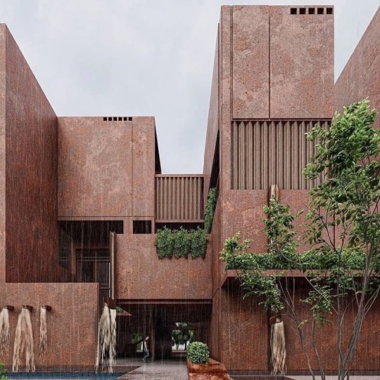
Design by #Archtec
#Archtec#Architectural#architecture#design#apartments#moderndesign#architectural#youtuber#archtec#Youtube#art#interior design#youtube#modern#house#home improvement#architecturephotography#decor#architectureanddesign#architecturelovers#architecturedesign#homedesign#homedecor#معماری#minimalism
58 notes
·
View notes
Text

Indoor space that looks outdoor.
Open home with corrugated metal exterior in Chau Doc, Vietnam
#photography#travel#rooms#travel photography#architecture#architecturedesign#interior design#design#interiors#interior#vietnam#stairs#photo#pics#photos#staircase
63 notes
·
View notes
Text

Some time ago I’ve seen a hyper realistic (or maybe ai?nowadays it’s hard to tell) painting of a castle and the design has been stuck in my head ever since. Decided to redraw it from memory, unfortunately I do not know the name of the original artist so let me know if you do :) I’d be grateful
#digital art#digital drawing#fantasy art#graphic design#original art#architecture#architect#art#artwork#procreate#landscape#castle#fantasy architecture#castle art#architecturedesign#worldbuilding#my post#my art#tumblr art#artists on tumblr#illustration
21 notes
·
View notes
Text


Hayat Residential Complex in Yazd, Iran 🇮🇷
instagram ℹ️
#Travelingwithoutmoving 🧭
#architecture #architecturephotography #architecturelovers #architectureporn #architecturedesign #architecturelover #architecturephoto #architecturedaily #architecture_hunter #architecturedetail #architecturephotos #architecturedose #architectureanddesign #architecturelife #architecturegram #architecturelove #architecturephotograpy #architectures #architectureinspiration #architecture_view #architektur #architekturfotografie #architekturfotograf #architektur_erleben #architekturliebe #architekturporn #architekturelovers
𝙷𝚎𝚖 𝙴𝚟𝚒𝚖𝚜𝚒𝚗 𝙷𝚎𝚖 𝙲𝚎𝚑𝚎𝚗𝚗𝚎𝚖𝚒𝚖 (𝚈𝚘𝚞 𝚊𝚛𝚎 𝚋𝚘𝚝𝚑 𝚖𝚢 𝚑𝚘𝚖𝚎 𝚊𝚗𝚍 𝚖𝚢 𝚑𝚎𝚕𝚕) 𝚋𝚢 𝙻𝚊𝚕𝚊𝚕𝚊𝚛 🇹🇷 🎧

#l o v e#Designer house#5/2024#Hayat Residential Complex in Yazd#Iran#Yazd#Hayat Residential Complex#Hayat Residential#architecture#aesthetic#travel#Persia#🇮🇷#iran 🇮🇷#architectureinspiration#architecturedose#architecturephotos#architecturelife#architecture details#architecturedaily#architecturelovers#architecturedesign#architecturephotography#traveling#x-heesy#now playing#music and art#contemporaryart#modern home
60 notes
·
View notes
Photo

Generative design leverages computational power to simulate thousands of iterations in response to design parameters like energy use, structural integrity, or spatial flow. This efficiency pushes the boundaries of what architects can achieve. Yet, it raises the question: are we training architects to critically curate machine-generated designs or to deepen their role in crafting unique, human-centered environments? Could generative design reduce the risk of design redundancies, or does it risk producing repetitive algorithmic solutions when overused?
#architecture#generativedesign#futureofarchitecture#parametricdesign#designthinking#aiarchitecture#architectsdebate#aesthetics#sustainabledesign#architecturalinnovation#parametric#architecturedesign#architectureanddesign#architecturemodels#architectureideas
14 notes
·
View notes
Text


+919168240606 Modern vibes, open skies. This bungalow redefines contemporary living with style and an open terrace to soak in the views. 🏡✨ . . Designed by @panashdesigns
#architect#Architectural#Architecturedesign#render#exteriordesing#exterior#interiordesign#interior#interiordecoration#interiordesigne#interiorarchitecture#interiorstyling#interiors#design#designer#homedecor#home#homedesing#homedecoration#minoomavadati#modern#luxury#archviz#archdaily#architecturelovers#rendering#projectusa#USA#internationalwork
14 notes
·
View notes
Text
Ford Mustang Mach 40
#animacion#animation#ford mustang#cars#automovilismo#3d render#architect santiago rojas#arquitecto santiago rojas#santiago rojas#photography#vehicle#suv#product design#demo#reels#ford#blue#architecturedesign#car#car clasics#car exhibition#art exhibition#Ford Mustang Mach 40#mustang#mach#40
18 notes
·
View notes
Text

Museo do Pobo Galego
6 notes
·
View notes

Text

Another old concept of mine. When I did it, I had a lot of free time.
#concept art#city#architecture#architecturedesign#traditional art#handrawn#dieselpunk#retro aesthetic#flying city#retro style
5 notes
·
View notes
Photo

It’s time for the Philippines to step towards cultural identities through architecture. And it starts with our proposed cultural port in Batangas City. Please subscribe at https://bit.ly/39QJbFv . .
#architecture#culture#harbor#architectureporn#architecturedesign#architectures#architecturedaily#movementculture#cultures#architectureandpeople#subculture#urbanculture#tropicalarchitecture#culturematters#cultureday#harborisland#travelculture#newculture#tourism#architectureproject#skyscraping_architecture#modernarchitect#philippines#port#architecturelovers#batangas#seaport
2 notes
·
View notes
Text

Design by #Archtec
#Archtec#Architectural#architecture#design#apartments#moderndesign#architectural#youtuber#archtec#Youtube#art#interior design#youtube#modern#house#home improvement#architecturephotography#decor#architectureanddesign#architecturelovers#architecturedesign#homedesign#homedecor#معماری
53 notes
·
View notes
Text

#exteriordesign#architecturalmodels#3drendering#architecturedesign#buildingmodels#exteriorarchitecture#architecturalvisualization#digitalmodels#physicalmodels#3darchitecturalmodels
2 notes
·
View notes
Text
Precision. Creativity. Innovation. Our expert team designs sustainable, innovative, and functional spaces that blend beauty with purpose. From Interior & Architecture to BIM, 3D Rendering, and MEP, we bring your vision to life with expertise and excellence. Your vision, our expertise – let’s build the future together.
#Designheed#architecture#interior#bimservices#mep#architect#architecturedesign#interiordesign#interiordesigner#interiors#OutlookDesignheed#bim consultants#bim consulting services#bim coordination services#bim modeling services#bim outsourcing services#bim services#bim technology#home interior
3 notes
·
View notes
Text


L o v e

How ancient architecture looked like
#Travelingwithoutmoving
#architecture #architecturephotography #architecturelovers #architectureporn #architecturedesign #architecturelover #architecturephoto #architecturedaily #architecture_hunter #architecturedetail #architecturephotos #architecturedose #architectureanddesign #architecturelife #architecturegram #architecturelove #architecturephotograpy #architectures #architectureinspiration #architecture_view #architektur #architekturfotografie #architekturfotograf #architektur_erleben #architekturliebe #architekturporn #architekturelovers
What A Wonderful World by Louis Armstrong 🎧

#l o v e#ancient history#ancient architecture#5/2024#architecture#illustrations#old building#aesthetic#art history#history#x-heesy#now playing#music and art#contemporaryart#What A Wonderful World#Louis Armstrong#cute#architecturelovers#architecturedesign#architectureporn#architecturelover#architecturephotography#nostalgia
77 notes
·
View notes
Text
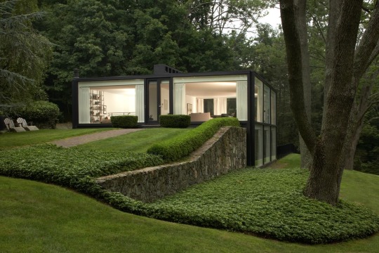

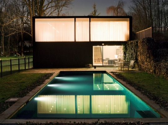
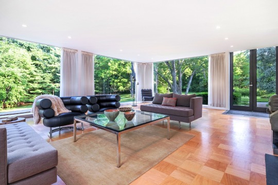
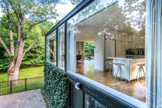
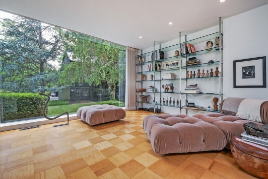
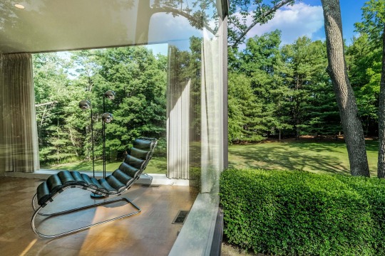
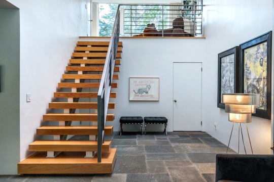
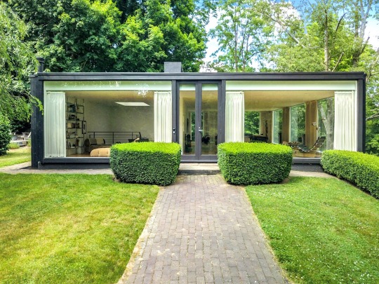
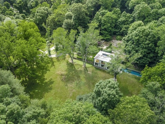
ROBERT FITZPATRICK — MINO RESIDENCE, 1967.
#ASTÉTICAS#ASTETICAS#HOME#HOUSE#ARCHITECTURE#DESIGN#ARCHITECTURE AND DESIGN#ARCHITECTUREDESIGN#DESIGNS#RESIDENCE#MID CENTURY MODERN#MID CENTURY#ROBERT FITZPATRICK#ARCHITECT#NY#NEW YORK
37 notes
·
View notes