#Aerial Survey
Explore tagged Tumblr posts
Visit Tumblr Blog
Explore Tumblr blogs with no restrictions, modern design and the best experience.
Last Seen Tumblr Blogs


Fun Fact
The KCSC sent more than 20K requests to delete posts related to prostitution and porn to Tumblr from January to June 2017.
Text
"Archaeologists using laser-sensing technology have detected what may be an ancient Mayan city cloaked by jungle in southern Mexico, authorities said Wednesday.
The lost city, dubbed Valeriana by researchers after the name of a nearby lagoon, may have been as densely settled as the better-known pre-Hispanic metropolis of Calakmul, in the south part of the Yucatan peninsula.
What the study, published this week in the journal Antiquity, suggest is that much of the seemingly empty, jungle-clad space between known Maya sites may once have been very heavily populated.
"Previous research has shown that a large part of the present-day state of Campeche is a landscape that was transformed by its ancient inhabitants," said Adriana Velázquez Morlet of Mexico's National Institute of Anthropology and History, a co-author of the report. "Now, this study shows that a little-known region was a urbanized landscape."
Mexico's National Institute said about 6,479 structures have been detected in LiDAR images covering an area of about 47 square miles (122 square kilometers). The technique maps landscapes using thousands of lasers pulses sent from a plane, which can detect variations in topography that ware not evident to the naked eye."
continue reading
#archaeology#mexico#mayans#history#lidar#lidar technology#research#science#discovery#humanity#culture#society#anthropology#aerial survey#jungle#technology#lasers#laser-sensor technology#past#city
6 notes
·
View notes
Text
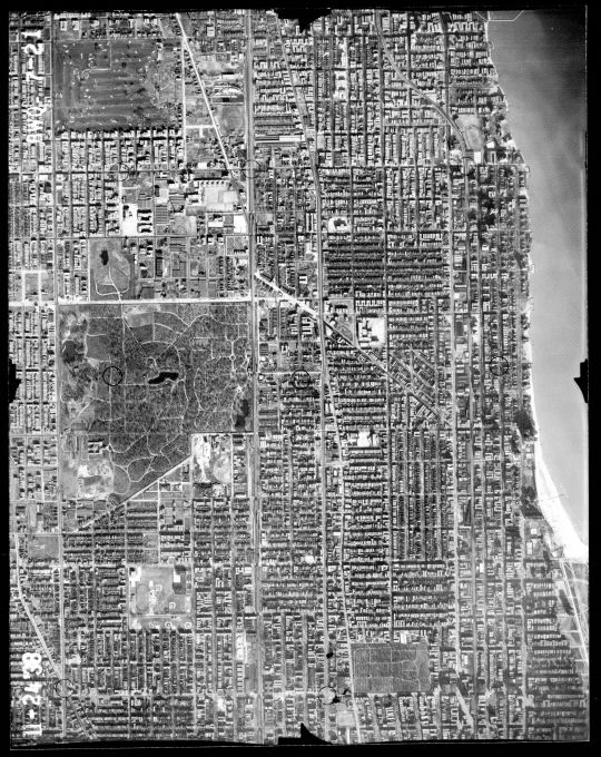
1939 Aerial Photo of the Edgewater area. The lakefront extension and Lake Shore Drive hasn't gotten past Foster Avenue yet. At left of center is Rosehill Cemetery, and to it's east is Senn High School, it's north wing not yet built. To the south of Rosehill is Winnemac Park with Amundsen High and Chappell Elementary. The prominent shadows at the lake front are the towers of the Edgewater Beach Hotel complex. At the upper left is the former Edgewater Golf Club, now Warren Park. At lower right is St Boniface Cemetery, and the Uptown Theater.
3 notes
·
View notes
Text
#GIS Mapping Survey in India#GIS Mapping Survey#GIS Mapping Company in India#Drone Survey#aerial photography survey#aerial survey
0 notes
Text
Drone Mapping | Drone Survey | AUAV
AUAV’s drone mapping solutions for Australia make it easier to collect complex data from above. They offer a variety of UAV services designed to suit your specific surveying needs. Choose AUAV for your next project to experience accurate and dependable drone survey services.

#Drone Mapping#Drone Survey#Australian Aerial Mapping#Aerial Survey#Drone Mapping Solutions Australia#Drone Survey Mapping Solutions#Aerial Survey using Drones#Aerial Survey Mapping Drones#Drone Survey Company
0 notes
Text
Unlocking the Power of Drone Surveys for Accurate Land Mapping

Introduction to Drone Surveys
What is a Drone Survey?
A drone survey involves using unmanned aerial vehicles (UAVs) to capture high-resolution images and other data for land mapping, environmental monitoring, and various types of surveying. Drones equip cameras, GPS, and LiDAR sensors to gather accurate data from the air. Specialized software then processes this data to create topographic maps, 3D models, and other useful representations of the land. Unlike traditional survey methods that require extensive manual labor and equipment, drone surveys offer a quicker and more efficient way to collect vast amounts of information. They commonly use drones in fields like construction, agriculture, mining, and environmental conservation, providing a modern, versatile solution for many surveying needs.
Importance of Drone Surveys in Land Mapping
Drone surveys play a critical role in land mapping by providing precise, up-to-date data with minimal disruption to the environment. Traditional land surveying methods often involve costly equipment, large teams, and long timelines, but drones can quickly cover vast areas, providing high-resolution imagery and detailed measurements. This efficiency allows land developers, urban planners, and environmentalists to make well-informed decisions faster. Drones also offer enhanced safety by enabling surveys of hard-to-reach or hazardous areas without putting human workers at risk. The use of drones in land mapping has transformed industries, offering a cost-effective, accurate, and safer way to gather essential data for planning and development projects.
Advantages of Drone Surveys for Land Mapping
Cost-Effectiveness
One of the biggest advantages of drone surveys for land mapping is their cost-effectiveness. Traditional surveying methods require expensive equipment such as total stations, GPS systems, and large teams of surveyors. Additionally, these methods often involve manual data collection, which can be time-consuming and labor-intensive. In contrast, drones can cover large areas quickly and efficiently, dramatically reducing labor costs. Drones capture data that software processes, automating many aspects of analysis and reducing the need for time-consuming manual calculations. Furthermore, drones eliminate the need for heavy machinery and minimize the risks and costs associated with surveying in hazardous or difficult-to-reach areas. By lowering operational costs, drone surveys provide a cost-efficient alternative for land mapping that benefits a wide range of industries, including construction, agriculture, and real estate development.
Increased Accuracy and Detail
Drone surveys offer significantly improved accuracy and detail compared to traditional survey methods. With advanced sensors like LiDAR and high-resolution cameras, drones can capture data with incredible precision, producing 3D models, contour maps, and digital elevation models (DEMs) that are highly accurate. The use of drones eliminates human error, ensuring consistent data collection across large areas. Additionally, the data gathered through drone surveys can be processed to provide more detailed and refined measurements, even in difficult terrains. This level of detail is invaluable in industries like land development, where accurate measurements are crucial for making informed decisions. Drones also allow for frequent updates, enabling real-time data collection and monitoring, which ensures that the land mapping is always up-to-date and reflects any changes in the environment. As a result, drone surveys provide highly reliable and detailed data that enhances planning and decision-making processes.
Urban Planning and Development
Drone surveys play a crucial role in urban planning and development by providing accurate, real-time data to help design, monitor, and execute infrastructure projects. Drones can capture high-resolution aerial imagery of large urban areas, creating detailed maps and 3D models that help planners visualize development projects and analyze land use. This technology aids in understanding terrain, identifying potential hazards, and assessing the suitability of land for various types of construction. Drones can also monitor ongoing construction projects, ensuring they stay on track and within budget. In crowded urban areas, drones can safely survey locations that might be difficult or unsafe for traditional surveying methods. By enabling more efficient and precise urban planning, drone surveys contribute to creating smarter, more sustainable cities.
Agriculture and Farming
Drone surveys have transformed the way land is analyzed and managed in agriculture and farming. Drones equipped with multispectral and thermal cameras can capture data about crop health, soil conditions, and irrigation efficiency. This data helps farmers optimize planting patterns, detect issues like pest infestations or diseases early, and adjust irrigation schedules to improve water usage. Drones also provide accurate volumetric measurements for stockpile management and field analysis. With the ability to cover large agricultural areas quickly and cost-effectively, drones allow farmers to make data-driven decisions that enhance productivity and sustainability. Additionally, drone surveys support precision agriculture practices, enabling farmers to tailor their operations to the specific needs of each plot of land.
Environmental Monitoring and Conservation
Drones are invaluable tools for environmental monitoring and conservation efforts, allowing for efficient data collection in remote or sensitive areas. These surveys help monitor biodiversity, track wildlife populations, and assess the health of ecosystems. By capturing high-resolution images, drones can track changes in forest cover, detect illegal activities like poaching or deforestation, and assess the effects of climate change on natural landscapes. Organizations use drones in conservation programs to create detailed habitat maps, allowing them to focus their efforts on preserving critical areas. By providing a non-invasive and cost-effective way to monitor vast areas, drones play a significant role in supporting environmental conservation and sustainable management of natural resources.
How Becoming a Pilot After 12th Opens New Career Opportunities in Drone Surveys
If you’re passionate about aviation and considering a career in drones, becoming a pilot after 12th can be a great path. While drones are a powerful tool in land surveying, they require skilled pilots for safe and efficient operation. With the demand for drone pilots growing, the aviation industry offers numerous opportunities for those who pursue their dream of becoming a licensed pilot. If you want to take this step, consider First Cockpit, a leading training institution where aspiring pilots can learn the necessary skills to fly drones and other aircraft.
Explore how you can become a pilot after 12th with First Cockpit’s tailored programs.
As the drone surveying industry continues to expand, having a background in piloting can open doors to a variety of roles in both traditional aviation and the emerging drone sector, making it a rewarding career choice.
Challenges and Considerations in Drone Surveys
Regulatory Issues
One of the significant challenges in drone surveys is navigating the complex regulatory landscape. Many countries, including India, have strict regulations governing drone flights, particularly in urban areas, near airports, or in restricted zones. Operators must ensure they have the necessary permits and licenses to fly drones legally. In addition, certain areas may require special permissions to operate drones due to concerns about privacy, safety, or national security. Compliance with local aviation laws, airspace restrictions, and insurance requirements is essential to ensure the safety of operations and avoid legal penalties. These regulatory hurdles can sometimes delay projects, making it critical for companies to stay up-to-date with evolving drone regulations and industry standards.
Technical Limitations
While drone surveys offer numerous advantages, they also come with technical limitations that can affect their effectiveness. For instance, drones are dependent on weather conditions; high winds, rain, or poor visibility can prevent them from flying safely and collecting accurate data. Additionally, drone battery life can be a limitation for larger land surveys, as batteries may need to be replaced or recharged after covering smaller areas. The accuracy of data is also contingent on the quality of the sensors and equipment used, and lower-quality devices may lead to suboptimal results. Drones may also struggle to capture precise data in highly cluttered environments or areas with dense vegetation. As drone technology continues to evolve, many of these challenges continue to be addressed, but surveyors and users in the field must still consider them.
Technological Advancements
The future of drone surveys in land mapping is closely tied to ongoing technological advancements. As drone technology evolves, we can expect significant improvements in data collection and processing capabilities. The integration of Artificial Intelligence (AI) and machine learning will enable drones to process and analyze data in real time, enhancing decision-making accuracy. Advanced sensors like LiDAR, hyperspectral imaging, and thermal cameras are becoming more compact and affordable, offering unprecedented detail and precision in land mapping. Drones are expected to have improved battery life and flight time, allowing them to cover larger areas without needing to land for recharging. These advancements will make drone surveys even more efficient, cost-effective, and reliable, opening up new possibilities for industries like construction, agriculture, and environmental conservation. As technology progresses, drones will continue to redefine how land surveys are conducted, enabling faster and more accurate results.
Expanding Applications
The applications of drone surveys in land mapping are set to expand dramatically in the future. Beyond traditional uses in construction and agriculture, drones will become increasingly essential in industries like urban planning, environmental monitoring, and even archaeology. Urban planners can use drones to conduct continuous, real-time assessments of growing cities, allowing them to visualize infrastructure development on a much larger scale. In environmental conservation, drones will help monitor changes in ecosystems with greater frequency and precision. As drones become more advanced, they could help in areas such as disaster management and climate change monitoring, where timely and accurate data is crucial. As drone technology continues to improve and more industries adopt this innovative tool, the scope of land mapping applications will continue to grow, providing new insights and efficiencies across a wide range of sectors.
1 note
·
View note
Text
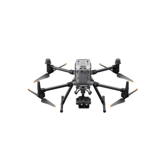
The DJI Matrice 350 RTK plays a pivotal role in construction by enhancing surveying, mapping, and monitoring processes. Equipped with high-precision RTK (Real-Time Kinematic) technology, this drone delivers centimeter-level accuracy, making it ideal for tasks such as site surveys, volumetric calculations, and progress tracking. Its robust payload capacity allows it to carry multiple sensors, including high-resolution cameras and LiDAR systems, which are essential for creating detailed, 3D maps of construction sites.
0 notes
Text
सीएम पुष्कर धामी ने आपदाग्रस्त क्षेत्रों का किया हवाई सर्वेक्षण, कहा, जल्द शुरू होगी चारधाम यात्रा
Uttarakhand News: मुख्यमंत्री पुष्कर सिंह धामी ने बाढ़ प्रभावित क्षेत्रों में जनजीवन सामान्य बनाने के लिए आवश्यक कदम उठाने के निर्देश देते हुए कहा कि क्षतिग्रस्त मार्गाें, पेयजल और विद्युत लाइनों को यथाशीघ्र बहाल किया जाए। उन्होंने केदारनाथ पैदलयात्रा मार्ग शीघ्र शुरू करने और हेली सेवा बुधवार से ही शुरू करने के निर्देश दिए। उन्होंने ऐलान किया हेलीकॉप्टर यात्रा की टिकटों में 25 फीसदी छूट राज्य…
0 notes
Text
#GIS Mapping Survey in India#GIS Mapping Survey#GIS Mapping Company in India#Geographic Information System#Drone Survey#aerial photography survey#aerial survey
0 notes
Text
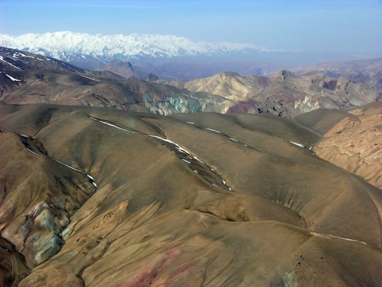
Colorful Mountains
Colorful Mountains — Look closely at this aerial shot of the colorful mountain ranges in Sar-e Pol, Afghanistan and you'll see hints of copper (the green) and iron (the red).
By U.S. Geological Survey
#us geological survey#photographer#flickr#mountains#sar-e pol#afghanistan#landscape#aerial photography#nature#copper#iron
14 notes
·
View notes
Text
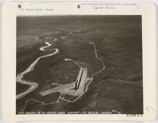
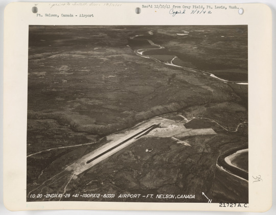
Fort Nelson Airfield, 1941
#Fort Nelson#Fort Nelson BC#British Columbia#airfield#1940s#1941#survey photo#aerial photo#photography#places#hide and queue
3 notes
·
View notes
Text
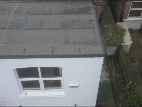
Professional Commercial Drone Inspections by UK National Roofing
Ensure the safety and longevity of your commercial property with expert commercial drone inspections from UK National Roofing. Our advanced drone technology allows us to efficiently capture high-resolution images, providing detailed assessments of your roof’s condition. This cost-effective solution helps identify potential issues without the need for scaffolding, saving you time and money. Trust UK National Roofing for reliable, thorough inspections that keep your commercial property in top shape. Visit us today to learn more!
#Roof Inspection Services#Drone Roof Inspections#Aerial Roof Surveys#Drone Inspection Technology#Roof Damage Assessment#Commercial Drone Inspections
0 notes
Text
Aerial Survey | Drone Survey | Drone Survey Company | AUAV
AUAV’s aerial survey using drones delivers efficient mapping and inspection data for industries across Australia. Let AUAV provide the aerial insights your projects need.

#Aerial Survey#Drone Mapping#Drone Survey#Aerial Mapping#Drone Mapping Solutions Australia#Drone Survey Mapping Solutions#Aerial Survey using Drones#Aerial Survey Mapping Drones#Drone Survey Company#Drones for Survey#Drone Land Surveying#Drone Surveying Australia
0 notes
Text
Unlocking the Power of Drone Surveying Services in Delhi: The Best Geospatial Solutions

In today’s fast-paced world, drone surveying services are proving to be a game-changer, especially in Delhi, where urban growth and infrastructure projects are booming. With the rapid advancements in drone technology in Delhi, industries have discovered a more efficient way to gather geospatial data, significantly transforming how surveys are conducted.
Aerial survey companies in Delhi are leading the charge by utilizing drones to provide high-precision data collection for a variety of industries. Whether it’s for construction, agriculture, or environmental monitoring, drones offer a level of accuracy that traditional methods simply can’t match. Gone are the days of relying on costly manual labor and time-consuming equipment. Instead, drones swiftly capture high-resolution images and 3D models, delivering valuable insights that streamline decision-making and reduce project timelines.
When searching for the best drone services, it’s crucial to choose a provider that offers comprehensive geospatial solutions. These solutions not only include aerial imagery but also topographical mapping, volumetric analysis, and real-time data collection. This makes drone services an invaluable asset for land assessments, project planning, and site management.
The rise of drone technology has made it easier for businesses to gather critical data in less time, at a lower cost, and with greater precision. Whether you need to monitor the progress of a construction project or assess land for agricultural purposes, drone surveying services in Delhi can provide the accuracy and speed needed to stay ahead of the competition.
With the continuous evolution of drone technology, the future of surveying is looking brighter than ever. By choosing the right aerial survey company in Delhi, you can unlock the full potential of drone technology and gain a competitive edge in your industry.
For innovative and reliable geospatial solutions, drone surveying services in Delhi offer the best way forward. Let the power of drones revolutionize your data collection processes and take your projects to new heights!
#drone technology#road construction#aerial mapping#surveying techniques#land development#construction planning
1 note
·
View note