Amateur weather nerd, front porch meteorologist, Skywarn certified storm spotter. Dealing with lilapsophobia through education and mild obsession. Living somewhere between Tornado Alley and Dixie Alley, so I get two tornado seasons.
Don't wanna be here? Send us removal request.
Photo

Shifting trends in US tornados: climate change is pushing them east
110 notes
·
View notes
Photo

Tornado paths over the continental USA for the past 70 years
249 notes
·
View notes
Photo
Oct. 20, 2019 North Dallas tornado

576 notes
·
View notes
Photo

64 notes
·
View notes
Text
This has been an incredible storm to watch. And I mean that in the most literal sense-- If I wasn't watching it happen with my own two eyes, I wouldn't believe it.

16 notes
·
View notes
Photo


Cumulonimbus is a dense, towering vertical cloud, forming from water vapor carried by powerful upward air currents. If observed during a storm, these clouds may be referred to as thunderheads.
1K notes
·
View notes
Photo

Every tornado of the 21st century in the contiguous United States.
406 notes
·
View notes
Text
Severe Weather in Arkansas, 4/13/18
Roof damage to Carmichael Hall at the University of Central Arkansas. The freshman women’s dorm residents were evacuated to the student center and no injuries were reported.
6 notes
·
View notes
Video
youtube
Tornado Alley. We hear the term a lot but do you actually know where it is? You may think you know, as everyone thinks they know…but the reality of the situation is tornado alley doesn’t actually have one set defined area that is…tornado alley.’ The simple fact is, tornadoes are pretty common over a big chunk of the US. The area in between the two major mountain ranges in the country, the Appalachians to the east and the Rockies to the west is where a huge majority of tornadoes happen in the country. Pinning down where within this area is tornado alley historically is pretty difficult and would depend on your criteria. What we call traditional tornado alley begins across Northern Texas and stretches northwards along the Great Plains throughout the entire middle of the country. Texas, Oklahoma, Kansas, Colorado, parts of Wyoming, Nebraska, South Dakota, Iowa, and Missouri are the traditional hotbeds of tornadoes. Traditional tornado alley is what a lot of people think of when it comes to…tornado alley. But the area just east of traditional tornado alley, including states like Minnesota, Illinois, Tennessee, Arkansas, Mississippi, and Alabama are historically active as well. In fact, the most violent tornadoes in terms of frequency occur along a northwest to southeast belt from Southern Kansas and Oklahoma into Arkansas, Mississippi, and Alabama historically. The simple truth is, this area between the Rockies and the Appalachians is particularly vulnerable to tornado activity. The reason for this is the Gulf of Mexico, featuring a hot and humid airmass, sits just to the south of the central 1/3 of the US. This airmass, when brought inland, becomes very unstable. Thanks to the jet stream aloft and the collision of air masses from both the desert southwest as well as the cool air coming from the north — the trigger point for storms to form within a favorable environment for tornadoes is set. The United States is unique in this way, and because of that we average more tornadoes than any other country — and its not even close! So when it comes to tornado alley, while you probably won’t get full agreement on where — lets just say that the middle part of the country in between the two major mountain ranges is certainly tornado alley to the rest of the world. Check us out on the web: http://ift.tt/1bwSWxW
8 notes
·
View notes
Text
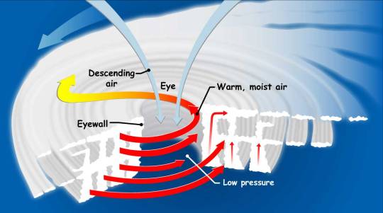
How Do Hurricanes Form?
Hurricanes are the most violent storms on Earth. People call these storms by other names, such as typhoons or cyclones, depending on where they occur.

The scientific term for ALL of these storms is tropical cyclone. Only tropical cyclones that form over the Atlantic Ocean or eastern and central Pacific Ocean are called “hurricanes.”

Whatever they are called, tropical cyclones all form the same way.
Tropical cyclones are like giant engines that use warm, moist air as fuel. That is why they form only over warm ocean waters near the equator. This warm, moist air rises and condenses to form clouds and storms.

As this warmer, moister air rises, there’s less air left near the Earth’s surface. Essentially, as this warm air rises, this causes an area of lower air pressure below.

This starts the ‘engine’ of the storm. To fill in the low pressure area, air from surrounding areas with higher air pressure pushes in. That “new” air near the Earth’s surface also gets heated by the warm ocean water so it also gets warmer and moister and then it rises.

As the warm air continues to rise, the surrounding air swirls in to take its place. The whole system of clouds and wind spins and grows, fed by the ocean’s heat and water evaporating from the surface.
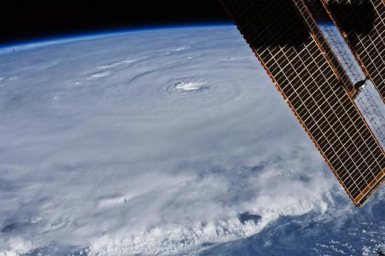
As the storm system rotates faster and faster, an eye forms in the center. It is vey calm and clear in the eye, with very low air pressure.

Tropical cyclones usually weaken when they hit land, because they are no longer being “fed” by the energy from the warm ocean waters. However, when they move inland, they can drop many inches of rain causing flooding as well as wind damage before they die out completely.
There are five types, or categories, of hurricanes. The scale of categories is called the Saffir-Simpson Hurricane Scale and they are based on wind speed.

How Does NASA Study Hurricanes?
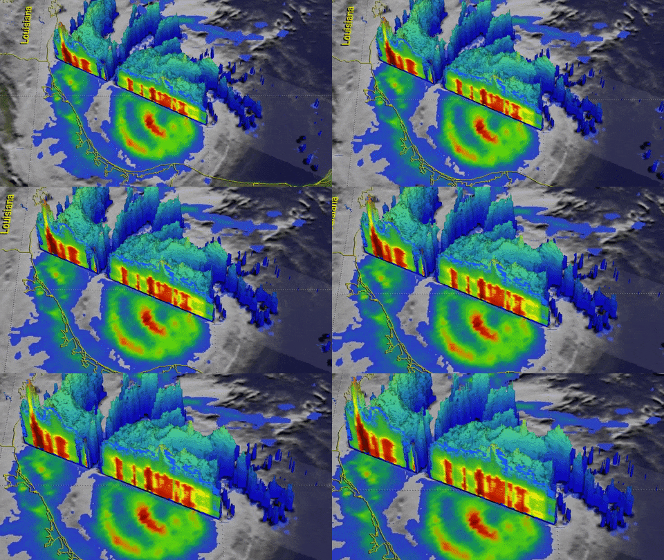
Our satellites gather information from space that are made into pictures. Some satellite instruments measure cloud and ocean temperatures. Others measure the height of clouds and how fast rain is falling. Still others measure the speed and direction of winds.

We also fly airplanes into and above hurricanes. The instruments aboard planes gather details about the storm. Some parts are too dangerous for people to fly into. To study these parts, we use airplanes that operate without people.
To learn more about how we study hurricanes, visit: https://www.nasa.gov/mission_pages/hurricanes/main/index.html
Make sure to follow us on Tumblr for your regular dose of space: http://nasa.tumblr.com.
8K notes
·
View notes
Photo

I’ve been storm chasing 15 years and I’ve def. never seen a fire from lightning start and then a Pyro cumulus cloud form a wall cloud
40 notes
·
View notes
Video
tumblr
#Tornado last week near McLean, #Texas. May 16, 2017. #texassky #texasweather #igtexas #weather #sky #nature_brilliance #nature_perfection #sky #clouds #storm #stormy #natureza #twister #stormchaser #badweather #instaweather http://ift.tt/2qJqc6s
23 notes
·
View notes


