#weather update-meteorological forecast
Explore tagged Tumblr posts
Visit Tumblr Blog
Explore Tumblr blogs with no restrictions, modern design and the best experience.
Last Seen Tumblr Blogs


Fun Fact
Kazakhstan’s Minister of Communications and Informatics has blocked the Tumblr site because it contained 60 sites of terrorism, extremism, and pornography in 2015.
Text
Heavy Rainfall Continues Across Jharkhand, Yellow Alert Issued
Meteorological Department Predicts Widespread Showers Until July 8 Farmers welcome rain for agriculture, but continuous downpours hinder paddy sowing. RANCHI – Jharkhand, including capital Ranchi, has been experiencing heavy rainfall since late Monday night, with the Meteorological Department forecasting continued showers until July 8. "A yellow alert has been issued for heavy rain and…
#Agricultural Impact Rainfall#राज्य#Jamshedpur weather update#Jharkhand Heavy Rainfall#Jharkhand Meteorological Department#Monsoon Jharkhand 2024#Paddy Sowing Challenges#Ranchi weather forecast#Simdega Waterlogging#state#Thunderstorm Warning Dhanbad#yellow alert Jharkhand
2 notes
·
View notes
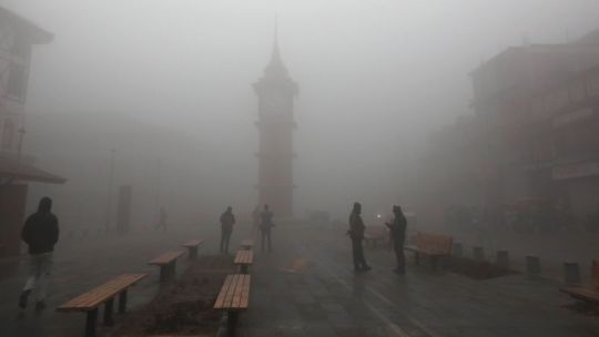
Text
Weather Update: Very dense fog, moderate rain likely in these states for next 3 days. Read IMD's forecast here
The India Meteorological Department has predicted dense fog over parts of northwest and adjoining central India during the next three days. Apart from this, according to the latest bulletin of IMD, there may be rain in Tamil Nadu also moderate rainfall From 30 December to 1 January 2024. According to the weather office, dense fog conditions have been predicted in the morning hours over isolated…
View On WordPress
#days#Dense#fog#fog situation in india#fog warning#foggy conditions in january#Forecast#imd weather news#IMD Weather Update#IMDs#India Meteorological Department#India weather news#India weather update#moderate#moderate rain likely in these states for next 3 days. Read IMD&039;s forecast here#Rain#rain in tamilnadu#Rain update in Tamil Nadu#Read#states#Update#weather#Weather Update: Very dense fog
0 notes
Photo

Weather Patterns, Winds, and Waves for 'Thu, 23 Jan 2025'
**January 23, 2025 (Thursday)** 🌤 Weather Overview for Today and Tomorrow Here's the weather and ocean conditions forecast for the Chiba area for January 24-25, 2025. Expect northwesterly to northeasterly winds, with stronger northeasterly winds over the sea. Waves are anticipated to be between 1.5 to 2 meters, possibly reaching 2.5 meters on the 25th, with some swell. The wind may cause choppy conditions. It's a neap tide, so be mindful of the high and low tide times. On the 24th, clouds will increase in the afternoon, with potential rain at night, so stay alert for weather changes. **Chiba Area Weather Summary (Choshi Local Meteorological Observatory)** Eastern Japan is under the influence of high pressure. Chiba Prefecture is currently experiencing clear skies. On the 23rd, high pressure will continue to bring sunny weather. On the 24th, while high pressure persists, a trough and moist air will lead to sunny skies turning cloudy in the afternoon, with possible rain at night. Along the Pacific coast of Chiba, expect moderate waves with some swell from the 23rd to the 24th. 🌊 Weather Map, Wind, and Wave Forecast for Tomorrow and the Day After **Chiba North/Chiba South Area Wind and Wave Forecast (Japan Meteorological Agency)** **Forecast for Tomorrow** 2025-01-24 - Chiba North Wind: Northwesterly, shifting to northeasterly, stronger over the sea - Chiba North Waves: 1.5 meters, increasing to 2 meters with swell - Chiba South Wind: Westerly, shifting to northerly, stronger over the sea - Chiba South Waves: 1.5 meters, increasing to 2 meters with swell **Forecast for the Day After Tomorrow** 2025-01-25 - Chiba North Wind: Northerly - Chiba North Waves: 2 meters - Chiba South Wind: Northerly - Chiba South Waves: 2 meters, increasing to 2.5 meters 🌊 Tide Information for Tomorrow (Chiba/Shonan Area) **Tide Information for Chiba (Katsuura) and Shonan (Enoshima)** **Chiba Area (Katsuura)** 2025/01/24 - Sunrise: 06:43 / Sunset: 16:58 - Neap Tide - High Tide: 10:37 (121cm) - Low Tide: 19:15 (39cm) **Shonan Area (Enoshima)** 2025/01/24 - Sunrise: 06:46 / Sunset: 17:01 - Neap Tide - High Tide: 02:29 (99cm) / 10:29 (119cm) - Low Tide: 04:22 (98cm) / 19:29 (39cm) That's all for today's update! #WeatherMap #PressurePattern #Tide #TideInformation #Calendar #Sunrise #Sunset #Surfing #Surf #Surfer #Wave #Swell #Tide #Chiba #Shonan --- **Announcement** I am excited to introduce my Kindle eBook series, "For Catching the Best Waves" (8 book series). https://www.amazon.com/s?i=digital-text&rh=p_27%3AHARUBEE&_encoding=UTF8&ref=dbs_mng_calw_a_1 The first book in the series, "For Catching the Best Waves," focuses on "Weekend Surfers," exploring various styles and how to catch the best waves with limited time. It provides foundational knowledge on reading weather maps to find the best surfing spots, making it a valuable resource for urban weekend surfers, beginners, and those new to surfing. By reading this series, you'll gain insights into which areas have waves based on daily weather maps. It's essential reading for weekend surfers to enjoy surfing safely and for beginners to understand the basics before heading to the beach. Through this book, I hope to share the allure and depth of surfing, helping readers understand the various meteorological and natural phenomena on Earth. It also aims to inspire thoughts on environmental conservation, ensuring we can continue to enjoy surfing in clean oceans.
6 notes
·
View notes
Text
Do the recent or right-now-ongoing crazy global weather scare you? Bother you? Interest you?
I'm pulling this from various media sources, because there is so much crazy weather happening now, or that has happened within the last couple of weeks, it seems like no single media source is picking it up.
From Heatmap AM:
Houston’s floods – More than 400 people in and around Houston, Texas, evacuated their homes over the weekend due to flooding. At least one person, a child, was killed. In one nearby county, more than 21 inches of rain fell over five days last week. The rain has tapered off but the cleanup has just begun.
Brazil’s rain – In Brazil’s southern state of Rio Grande do Sul, days of intense rain caused the Guaiba River to overflow and flood more than 340 cities, including the region’s capital of Porto Alegre. At least 78 people are dead and more than 115,000 have been forced to evacuate. One climatologist calledthe catastrophe “a disastrous cocktail” of climate change and the El Niño effect. “It looks like a scene out of a war,” said Rio Grande do Sul governor Eduardo Leite.
Chile’s fires – Fires in Chile’s Valparaiso region, fueled by an intense heat wave and enduring drought, have killed at least 51 people and burned more than 64,000 acres.
Kenya’s deluge – Flooding and landslides in Kenya from unrelenting rainfall have killed more than 200 people. It is still raining and the weather is forecast to worsen throughout the month of May.
Southeast Asia’s heat wave – A lengthy heat wave has shattered temperature records across Southeast Asia, forcing many schools to close. One weather historian called the heat wave “the most extreme event in world climatic history.”
From the Associated Press (AP):
A weekend spring storm that drenched the San Francisco Bay area and closed Northern California mountain highways also set a single-day snowfall record for the season on Sunday (May 5) in the Sierra Nevada. The wet weather system had mostly moved out of the state by Sunday morning, but officials warned that roads would remain slick after around two feet (60 centimeters) of snow fell in some areas of the Sierra. “Did anyone have the snowiest day of the 2023/2024 season being in May on their winter bingo card?” the University of California, Berkeley Central Sierra Snow Lab asked on the social platform X. The 26.4 inches (67 centimeters) of snowfall on Sunday beat the second snowiest day of the season — March 3rd — by 2.6 inches (6.6 centimeters), according to the lab.
From Yale Climate Connections:
For the first time since the 2010s, a high-risk outlook for severe weather (level 5 of 5) has been issued for parts of the Great Plains. The outlook was put in place at 8 a.m. EDT Monday, May 6, and updated at 12:30 p.m. EDT Monday by the NOAA/National Weather Service Storm Prediction Center, as a busy few days of severe weather moved into high gear. Dozens of tornadoes could erupt by midweek, including in and near Oklahoma on Monday and across a broad swath of the mid-Mississippi and lower Ohio River valleys on Wednesday. Many of the worst tornado U.S. outbreaks of recent years have played out across the Mississippi Valley and Southeast, but multiple rounds of twisters have hammered the Plains since late April, taking at least seven lives and wreaking what will no doubt be hundreds of millions of dollars in damage.
From Wikipedia:
On 16 April 2024, heavy rains caused floods in the United Arab Emirates, affected cities of mainly Dubai and Sharjah, the northern Emirates, and different areas of the Emirate of Ras Al Khaimah. According to the National Center for Meteorology (United Arab Emirates) , this was the country's heaviest rainfall recorded in 75 years. The floods in the Emirates were a part of the greater Persian Gulf floods.
14 notes
·
View notes
Text
UK forecasters warn Storm Eowyn poses “danger to life”
A life-threatening warning has been issued for the UK ahead of Storm Eowyn on Thursday.
Winter Storm Eowyn is gaining strength, strengthened by an Arctic blast that has travelled across the US, and could cause power cuts and transport disruption across the UK later this week.
Winds are forecast to be strong enough to cause structural damage and bring down branches and power lines, and are expected to disrupt transport on roads, trains and ferries. National Rail is already warning of possible disruption over the weekend.
Ireland braces for Eowyn
Ireland is preparing for the imminent arrival of Storm Eowyn, which meteorologists predict could be one of the most powerful storms ever to hit the country. The storm is expected to make landfall soon, bringing extreme weather conditions including winds of up to 140 kilometres per hour, heavy rainfall and possible flooding.
Met Éireann has issued several weather warnings, including a yellow warning status for all coastal areas, which will change to an orange warning status as the storm intensifies. The storm is expected to cause widespread damage, particularly in the south-west, west and central parts of the country.
Cathal Nolan of the Irish Meteorological Channel said the storm is undergoing rapid cyclogenesis into a life-threatening event with hurricane-force winds expected in coastal areas. Gusts could exceed 200 kilometres per hour in some locations, posing significant risks for structural damage, power outages and transport disruptions.
As the storm approaches, residents are advised to take precautions, including protecting their property and avoiding unnecessary travel. The combination of strong winds and heavy precipitation could lead to hazardous conditions, including blizzard-like scenarios in high areas.
In addition to the storm warnings, a yellow fog warning remains in effect for 21 counties, further complicating travel and visibility as the nation prepares for the storm.
Authorities are closely monitoring the situation and will provide updates as the storm develops. Residents are advised to stay informed through official channels and follow all safety recommendations.
Read more HERE

#world news#news#world politics#europe#european news#uk#uk politics#uk news#united kingdom#england#politics#ireland#storm eowyn#eowyn#weather#weather report#weather news#weather forecast
2 notes
·
View notes
Text
Brazil: Adverse weather forecast across southeastern regions through at least Jan. 28
Heavy rainfall forecast over southeastern Brazil through at least Jan. 28. Flooding, landslides, and transport disruptions possible.

Heavy rainfall is forecast across parts of southeastern Brazil through at least Jan. 28. Some coastal parts of the region may receive rainfall accumulations of more than 30 cm (12 inches) through Jan. 28. Thunderstorms and strong winds may accompany the heavy downpours. Sustained heavy rainfall could trigger flooding in low-lying areas and landslides on unstable slopes. Transport disruptions and power outages are also possible in affected areas.
As of early Jan. 25, Brazil's National Institute of Meteorology (Inmet) has issued red (the highest level on a three-tier scale) heavy rainfall warnings for coastal areas of Parana, northern Santa Catarina, and Sao Paulo. Orange heavy rainfall warnings are in place for a slightly wider area along the coasts of Parana, Santa Catarina. and central and southern Sao Paulo. Yellow warnings have been issued across much of the rest of the affected area. Officials could update and possibly extend the coverage of the relevant weather alerts over the coming days.
Sustained heavy rainfall could trigger flooding in low-lying communities near rivers, streams, and creeks. In developed areas with easily overwhelmed stormwater drainage systems, additional urban flooding is also possible. Sites downstream from large reservoirs or rivers may be subject to flash flooding after relatively short periods of intense rainfall. Landslides remain possible in hilly or mountainous areas, especially where heavy rainfall has saturated the soil. Power outages and disruptions to telecommunications services are likely where significant flooding, landslides, or strong winds impact utility networks.
Continue reading.
#brazil#brazilian politics#politics#environmentalism#environmental justice#mod nise da silveira#image description in alt
3 notes
·
View notes
Text
How Technology is Transforming Commercial Snow Removal in Toronto

Introduction: A New Era of Snow Removal
Toronto winters are no joke, and managing the heavy snowfall can be a daunting task for businesses. However, the advent of cutting-edge technology is revolutionizing how snow is handled. From GPS-enabled equipment to advanced weather tracking, commercial snow removal has never been more efficient, reliable, and innovative. This article explores the various technological advancements shaping the industry and how they benefit businesses in Toronto.
Advanced Snow Removal Equipment
The Role of GPS Technology
Gone are the days of manual plowing with minimal precision. Modern snow removal machines come equipped with GPS technology, allowing operators to track routes, optimize plowing patterns, and ensure no area is left untouched. This not only saves time but also reduces operational costs by minimizing fuel consumption.
Eco-Friendly Machinery
Sustainability is becoming a priority in every industry, and snow removal is no exception. The introduction of hybrid and electric snowplows reduces environmental impact while maintaining the efficiency needed to clear large commercial properties. These machines are quieter, greener, and equally powerful as their traditional counterparts.
Predictive Weather Tools
Accurate Weather Forecasting
Accurate and timely weather data is crucial for effective snow management. Advanced meteorological tools and software provide real-time updates, helping businesses and snow removal services prepare for incoming storms. These systems analyse weather patterns, predict snowfall intensity, and enable proactive planning.
Smart Alerts and Notifications
Businesses can now receive automated alerts about weather changes. These notifications allow property managers to schedule snow removal services in advance, ensuring smooth operations and uninterrupted accessibility during harsh weather conditions.
Automation and Robotics in Snow Removal
Autonomous Snowplows
The rise of autonomous technology has introduced self-driving snowplows, which are transforming commercial snow removal. These machines operate with minimal human intervention, using sensors and AI to navigate complex terrains and efficiently clear snow.
Robotic Salt Spreaders
Robotic salt spreaders are another innovation enhancing snow management. These devices precisely distribute de-icing materials, reducing waste and ensuring safety on walkways and parking lots.
Cloud-Based Management Systems
Streamlined Operations
Cloud-based platforms enable seamless coordination between snow removal teams and business owners. These systems allow for real-time updates, job tracking, and easy communication, ensuring transparency and efficiency in service delivery.
Data-Driven Decision Making
With data analytics integrated into these platforms, companies can assess the effectiveness of their snow removal strategies. From monitoring equipment performance to evaluating service timelines, data-driven insights help optimize operations for better results.
Mobile Apps for Customer Convenience
On-Demand Snow Removal Services
Mobile apps have made snow removal more accessible than ever. Businesses can now book services on demand, track the status of their requests, and even make payments—all from the convenience of their smartphones.
Enhanced Customer Experience
These apps provide detailed information about service providers, estimated arrival times, and completion reports. Such features ensure a hassle-free experience, building trust between businesses and snow removal companies.
Toronto’s Adoption of Technology in Snow Removal
Setting Industry Standards
Toronto has always been a frontrunner in embracing innovation. The city’s commercial snow removal companies are adopting these technologies to deliver superior service, ensuring safety and accessibility throughout the winter months.
Benefits for Local Businesses
By leveraging technological advancements, Toronto businesses can save time, reduce costs, and maintain a professional appearance during snowy conditions. The integration of tech-driven solutions guarantees a smoother winter experience for everyone involved.
Conclusion: Embracing a Tech-Driven Future
Technology is undeniably transforming the landscape of commercial snow removal in Toronto. From predictive tools and automated equipment to customer-friendly apps, these advancements are setting new benchmarks in efficiency and reliability. For businesses, staying ahead of the curve means partnering with snow removal services that embrace innovation. With the right technology, Toronto can tackle even the harshest winters with ease.
0 notes
Text
🌸 2025 Cherry Blossom Forecast 🌸
The Japan Meteorological Corporation has just released its first Sakura forecast of 2025!
While we’re still in the middle of January, it’s exciting to see that cherry blossoms are already on the horizon.
Here’s the forecast for when the blossoms are expected to open across Japan:
• Fukuoka (福岡): March 22
• Osaka (大阪): March 27
• Nagoya (名古屋): March 24
• Tokyo (東京): March 24
• Sendai (仙台): April 7
• Sapporo (札幌): April 30
As usual, the flowers will bloom earlier in the warmer southern regions and later in the cooler northern areas like Hokkaido.
This year’s forecast suggests that cherry blossoms will bloom around the same time as they have in recent years.
However, keep in mind that it’s still early in the year, and changes in the weather could impact the timing.
Last year, for example, cooler temperatures in early spring caused the blossoms to open later than expected.
Stay tuned for updates, and start planning your hanami (flower viewing) outings! 🌸

0 notes
Text
MetMalaysia Issues Rain Alert for Johor Districts
The Malaysian Meteorological Department (MetMalaysia) has forecasted continuous rain in six Johor districts today. Based on an 8:30 am weather alert, the affected areas include Kluang, Mersing, Pontian, Kulai, Kota Tinggi, and Johor Bahru. MetMalaysia Issues Rain Alert for Johor Districts The public is advised to stay updated via MetMalaysia’s official website, the myCuaca mobile app, or their…
0 notes
Text
Weak Rainfall Anticipated in Jharkhand Over Next Few Days
No severe rainfall alerts have been issued for the state; IMD predicts light to moderate rainfall. Due to a subdued monsoon, Jharkhand anticipates limited rainfall over the next 3-4 days, with a gradual increase in maximum temperatures. RANCHI – The Ranchi Meteorological Centre of IMD anticipates that Jharkhand will experience mild to moderate rainfall over the next five days, with no heavy…
#राज्य#cyclonic circulation Bay of Bengal#IMD rainfall prediction#Jharkhand district rainfall#Jharkhand temperature rise#Jharkhand weather forecast#low-pressure system Bay of Bengal#monsoon trough India#Ranchi Meteorological Centre forecast#state#subdued monsoon Jharkhand#weather update eastern India
0 notes
Text
Market sizing

Meet Jhonnery. He and his father are hardworking farmers from Barangay Impasug-ong, Bukidnon, who grow tomatoes, eggplants, and other crops and they also raise some chicken. Jhonnery, like many farmers, relies on his phone, radio, and television for weather updates, but these sources frequently provide general forecasts that may not accurately reflect the real weather conditions on his farm.
Without precise knowledge, Jhonnery confronts issues such as overwatering his crops, delayed planting, and even harvest loss due to unforeseen weather events. AgriWeather provides a bespoke solution with hyper-localized weather forecasts and actionable analytics, allowing farmers like him to make informed decisions and farm confidently.


These are the questions that i asked him:
Which services or technologies do you currently use for weather monitoring? What aspects of these technologies appeal to you, and what drawbacks or restrictions have you encountered?
How can you plan and oversee important farming tasks like planting, watering, and harvesting with the help of these meteorological tools? Have you run into any issues or errors with these tools that have affected your farm operations or crop yield?
Realizations/Insights from the Interview:
Farmers like Jhonnery rely heavily on general weather updates from phones, radios, and televisions, which frequently fail to provide trustworthy, farm-specific data since these technologies may gather information from multiple sources, resulting in an inconsistent result that can harm Jhonnery's crops. This gap makes it impossible for Jhonnery to plan key farming tasks such as planting, watering, and harvesting. He explained that unexpected weather typically leads to resource depletion, poor productivity, and crop loss.
Jhonnery expressed a strong desire for a user-friendly solution that provides hyper-localized weather updates and actionable advise specific to his farm. He feels that such a method will allow him to maximize resource utilization, eliminate losses, and dramatically increase his farming results.
0 notes
Text

🌨️☔ Light Rain and Snowfall Predicted in Koshi Province’s Mountainous Region ☔🌨️
The mountainous and hilly regions of Koshi, Bagmati, Gandaki, and Sudurpaschim provinces are expected to have partly cloudy skies today, with chances of light rain and snowfall in one or two places in the mountainous areas of Koshi Province, as per the Meteorological Forecasting Division.
🌟 Tarai Region Update: The weather is predicted to remain mostly fair during the day, but morning fog may disrupt daily life, road transport, and air travel.
🌌 Tonight: Expect partly cloudy skies with a possibility of scattered light snowfall in Koshi’s mountainous region.
📢 Precautionary Measures:
The Division advises caution for those involved in tourism, mountaineering, and transportation, especially in areas affected by fog.
Stay safe and plan ahead! 🌄❄️
#WeatherUpdate #KoshiProvince #SnowfallAlert #NepalWeather #StaySafe
0 notes
Photo

Weather Patterns, Winds, and Waves for 'Tue, 28 Jan 2025'
**January 27, 2025 (Monday)** 🌤 **Weather Overview for Today and Tomorrow** Here's the atmospheric pressure, wind, and wave information for today and tomorrow in the Chiba area. In the Chiba region, there is a possibility of moderately strong westerly winds on January 28. The winds are expected to intensify, especially offshore, potentially affecting wave conditions. Wave heights could reach 2.5 to 3 meters in northern Chiba and 2.5 to 4 meters in southern Chiba, accompanied by swells. The tide will be moderate, with high tides expected in the early morning and afternoon, and low tides in the morning and evening. The weather will be mostly cloudy with occasional sunshine, and there is a chance of rain until dawn. Surfers may enjoy the waves, but should be cautious of the wind and wave conditions. Let's take a closer look at the detailed forecast. **Chiba Area Weather Overview (Choshi Local Meteorological Observatory Announcement)** The Kanto-Koshin region is gradually covered by high pressure, while a low-pressure system is moving northeast from the south of the Kii Peninsula. Chiba Prefecture is currently cloudy. On the 27th, due to the influence of the low-pressure system and moist air, it will be cloudy with some areas experiencing rain at night. On the 28th, as the low-pressure system moves near the Izu Islands and progresses eastward, the atmospheric pressure will shift to a west-high-east-low pattern, resulting in cloudy weather with occasional sunshine and rain expected until dawn. In the Pacific coastal waters of Chiba Prefecture, waves will be high with swells on the 27th. On the 28th, the sea is expected to be rough with swells. Vessels should be cautious of high waves. 🌊 **Weather Map, Wind, and Wave Forecast for Tomorrow and the Day After** **Chiba North/South Area Wind and Wave Forecast (Japan Meteorological Agency Announcement)** **Forecast for Tomorrow** 2025-01-28 - **Chiba North Wind:** Westerly, becoming moderately strong; strong offshore later - **Chiba North Waves:** 2.5 meters, increasing to 3 meters with swells - **Chiba South Wind:** Westerly, becoming moderately strong; strong in Isumi and Awa - **Chiba South Waves:** 2.5 meters, increasing to 4 meters with swells **Forecast for the Day After Tomorrow** 2025-01-29 - **Chiba North Wind:** Moderately strong westerly - **Chiba North Waves:** 3 meters - **Chiba South Wind:** Moderately strong westerly - **Chiba South Waves:** 4 meters 🌊 **Tide Information for Tomorrow (Chiba and Shonan Area)** **Tide Information for Chiba (Katsuura) and Shonan (Enoshima)** **Chiba Area (Katsuura)** 2025/01/28 - Sunrise: 06:40 / Sunset: 17:03 - Moderate Tide - High Tide: 05:06 (131cm) / 15:06 (138cm) - Low Tide: 10:02 (91cm) / 22:24 (-8cm) **Shonan Area (Enoshima)** 2025/01/28 - Sunrise: 06:44 / Sunset: 17:05 - Moderate Tide - High Tide: 05:25 (138cm) / 15:22 (138cm) - Low Tide: 10:26 (93cm) / 22:47 (-7cm) That's all for today's update! #WeatherMap #PressurePattern #Tide #TideInformation #Sunrise #Sunset #Surfing #Surf #Surfer #Wave #Swell #Tide #Chiba #Shonan --- **Announcement** I would like to introduce my Kindle eBook series. **Riding the Perfect Wave (8 book series)** https://www.amazon.com/s?i=digital-text&rh=p_27%3AHARUBEE&_encoding=UTF8&ref=dbs_mng_calw_a_1 This series, "Riding the Perfect Wave," begins with a focus on "Weekend Surfers," exploring various styles and how to catch the best waves within limited time. It provides foundational knowledge on reading weather maps to find the best surfing spots. For city-dwelling weekend surfers, beginners, or those new to surfing, this book offers valuable insights on choosing the right beach. By reading this series, you'll gradually learn to identify which areas have good waves based on daily weather maps. This book serves as essential information for weekend surfers to enjoy surfing safely. It's a must-read for beginners before heading to the beach, offering insights into the allure and depth of surfing, and understanding the various meteorological and natural phenomena on Earth. It also encourages readers to consider environmental conservation, ensuring we can continue to enjoy surfing in clean oceans.
3 notes
·
View notes
Text
Met Office shares Christmas weather update with snow possible in parts of UK
The Met Office has shared its Christmas weather update, with snow likely in parts of the UK. The Meteorological Department has issued a new long-range forecast Source link
0 notes
Text
[ad_1] Heavy Rain Triggers Flood Warnings Across Tamil Nadu, Thamirabarani in Spate GG News Bureau Chennai, 13th Dec. Continuous downpours across Tamil Nadu have led to flooding in several districts, with the Thamirabarani river in spate. Authorities have issued flood warnings for low-lying areas, particularly in the Srivaikuntam and Eral regions of Thoothukudi district, urging residents to move to safer locations. In Chennai, the Public Works Department (PWD) has issued the first flood warning near the Redhills and Chembarambakkam reservoirs, key sources of drinking water for the city, as water levels have surged dangerously. Discharge from the Poondi dam was increased to 12,000 cusecs this morning from 5,000 cusecs on Thursday evening. Impact Across the State Thoothukudi and Tirunelveli Districts: Revenue officials are evacuating residents in vulnerable areas near the Thamirabarani. Chengalpattu District: A stranded bus in Maduranthakam was towed to safety; no injuries were reported. Tenkasi District: A Primary Health Centre in Vadakarai was inundated, and rainwater entered the Sankaranarayana temple in Sankarankoil. Despite the adverse weather, preparations at Thiruvannamalai’s Sri Arunachaleswar temple continued for the Maha Deepam lighting, marking the conclusion of a ten-day festival. IMD Forecast The India Meteorological Department (IMD) attributed the heavy rain to a well-marked low-pressure area over the Southwest Bay of Bengal, now located over the Gulf of Mannar. The system is expected to weaken gradually in the next 12 hours. Heavy rainfall is forecast for 14 districts, with residents advised to remain vigilant. Authorities, including police and rescue services, are working to mitigate the impact of the severe weather, prioritizing the safety of affected communities. The post Heavy Rain Triggers Flood Warnings Across Tamil Nadu, Thamirabarani in Spate appeared first on Global Governance News- Asia's First Bilingual News portal for Global News and Updates. [ad_2] Source link
0 notes
Text
Brazil: Disruptions due to flooding ongoing across parts of Santa Catarina State as of Oct. 12
Disruptions due to flooding ongoing across Santa Catarina State, Brazil, as of Oct. 12. Further adverse weather forecast.

Disruptions due to heavy rainfall and flooding are ongoing across parts of Santa Catarina State as of Oct. 12. The adverse weather has affected at least 138 of the state's 295 municipalities; around 98 municipalities are under a local state of emergency. As of early Oct. 12, authorities say there are at least two weather-related fatalities across the state. More than 12,000 people are displaced. Floodwaters have submerged or damaged several roads.
Further severe weather is likely in the region through at least Oct. 13 due to the passage of a cold front. Rainfall totals of 7-10 cm (2.8-3.9 inches) are expected in parts of the region Oct. 12; additional heavy downpours could trigger further flooding and associated disruptions. As of early Oct. 12, the National Institute of Meteorology (INMET) has issued orange storm warnings across Santa Catarina State. Officials will likely update and possibly extend the coverage of weather alerts over the coming days.
Further sustained heavy rainfall could trigger additional flooding in low-lying communities near rivers, streams, and creeks. Urban flooding is also possible in developed areas with easily overwhelmed or a lack of stormwater drainage systems. Sites downstream from large reservoirs or rivers may be subject to flash flooding after relatively short periods of intense rainfall. Landslides are possible in hilly or mountainous areas, especially where heavy rain has saturated the soil. Disruptions to electricity and telecommunications services are likely where significant flooding, landslides, or strong winds impact utility networks.
Continue reading.
#brazil#brazilian politics#politics#environmentalism#environmental justice#mod nise da silveira#image description in alt
2 notes
·
View notes