#weather in Belize
Explore tagged Tumblr posts
Visit Tumblr Blog
Explore Tumblr blogs with no restrictions, modern design and the best experience.
Last Seen Tumblr Blogs


Fun Fact
Tumblr’s website traffic is steadily declining.
Text

Is this amphibian a visitor from outer space? 🛸Nope… it’s the Yucatan casque-headed tree frog (Triprion petasatus), a species that can be found in parts of Mexico, Belize, and Guatemala. How does it put its head casque, or “helmet” to use? When the weather is dry, this frog has been observed nestling into tree holes. It plugs the opening with its hard head, using it as a barrier against the outside world. This is thought to help the frog retain extra moisture in its skin!
Photo: angel_trres, CC BY-NC 4.0, iNaturalist
485 notes
·
View notes
Text

SERPENTINE PROMISE | Hidden in Plain Sight.
Serpentine Promise is a 16+ literate Horror / Slasher Warriors RP set on the coast of Belize in the heart of a meteor crater called the Cardinal. This RP takes heavy inspiration from the beautiful indigenous Mayan cultures of Belize for its worldbuilding.
You are part of three groups known as Arrows. You live in relative peace, guided by your Celestial Leaders in the skies above - the Jade Tiger, the Red Tiger, and the Gold Tiger. Centuries prior, these three leaders created the Arrows, but in doing so created something worse. The North Serpent wanted the crater for itself, and would only be satisfied when it ate the sun. The three tigers fought together against the serpent to the death.
In modern times, these Celestial Leaders are growing increasingly distraught, until they disappear one night and leave you with nothing but an omen … Cats around you begin to drop dead soon after. Your objective? Survive. Keep one eye open. Figure out which one of you is slaughtering cats by the dozen, or die trying.
𓆙 ━─┈
🌊THE EAST WAVES Living on the sandy coasts of the Cardinal, the cats of the East Waves are weathered, brave, regal, and know their way around the barrier reef, and the raging seas. 🌴THE SOUTH RAINS Nestled in the dense, lush rainforest of the crater, the cats of the South Rains are intelligent, agile, gifted and flighty. They know how to traverse the land without ever placing a paw on the dangerous jungle floor.
⛰️THE WEST PEAKS Settled in the mountains along the edge of the crater, living within caverns and along cliff faces, cats in the West Peaks are hardy, strong, tough and independent, battling the biggest threats of all — Harpy eagles, amongst other dangerous raptors. 𓆙 ━─┈ WHAT WE OFFER🐍
A safe, secure environment for all with safety nets in place for any incident that would otherwise occur in a large space.
A server open to writers of any experience.
An extremely large expanse of lore and world-building including a glossary of brand new terms, in-depth lore and history inspired by Mayan cultures, unique ranks and roles to each Arrow, and an entirely new herb and medicine system created entirely for the RP, amongst a dozen other additions!
A server run by BIPOC and LGBT+ moderators, including a Belizean admin and consultant.
High Ranks and Roles open for application for writers of any experience and skill level!
RP affiliation / partnership — advertise your RP server in ours!
EXPLORE THE WORLD & APPLY NOW! >> https://serpentinepromise.carrd.co/ << =
(please note that i, nanistar, am NOT the host of this RP. i am merely a moderator and the tumblr liaison. i can answer some basic questions, but for anything more in-depth else please contact BADMIRACLE on tumblr. he is an amazing rp host and has spent months bringing this together and developing this rp.)
#serprom#warrior cats#warriors oc#warriors rp#warrior cats rp#open rp#open wc rp#warriors role play#wcrp#discord wcrp#not my art
269 notes
·
View notes
Text
Like yes merpeople but ALSO what about merpeople who are specifically half-shark, or the underwater equivalent of giants, half-human/half-whale? We've got the occasional half-human/half-octopus but also yes to half human jellyfish and half human manta rays and not naiads specifically so much as the underwater equivalent of dryads, having the same connection to coral gardens and reefs that dryads do to trees and forests.
Gimme underwater lamias who are actually more accurately half human/half electric eel, with all the associated zapping ability, that lends them insight into electricity and related phenomena they use to build high-tech wonderlands deep beneath the waves.....and far from any shore, underwater travelers fear crossing paths with 'ghosts' which are actually like a supernatural form of jellyfish who wrap their translucent selves around their victims to "possess them."
I want selkies who don't just come ashore to have angsty love affairs with beguiling humans, but who also live in communities deep in arctic regions far away from any human civilization where they carve entire villages and cities into the undersides of icebergs.
Underwater vampiric creatures, maybe lamprey or shark themed, who specifically drink blood for the oxygen in it, as that's what enables them to go 'top side' for awhile before having to retreat back to the depths they're more naturally adapted to live in. Krakens but also a Fae-like version of angler fish who use their lights as an undersea version of will'o'wisps, leading denizens of the deep astray.
Multiple types of undersea shapeshifters, going to and from the surface and the deep, with entirely different branches of the same shapeshifter family trees.....the dolphin shapeshifters of the Mediterranean being descendants of the sailors cursed by Dionysus and having very little in common with the encantado who live in the waters of South America, but often lumped in with each other and sharing similar issues and interactions with other civilizations due to the fact that so many others just assume all dolphin shapeshifters are connected or alike even though they have completely different natures, parameters for their shapeshifting, and an entire spectrum of supernatural abilities with very little actual overlap between the different 'types.'
Not just one god of the sea, but multiple gods of the deep, all associated with their own regions, from Poseidon to Sedna to Tangaroa to Manannán mac Lir and Kimbazi. The deep sea equivalent of druids, cultivating kelp forests and coral groves and gardens warmed and nourished by the undersea volcanoes they're planted in the shadows of. Sorcerers as fixated on trying to control and harness and direct the power and positioning of underwater currents as above-the-sea counterparts are with trying to control the weather.
Narwhales often mistaken for the unicorns of the deep, but only because there actually ARE an undersea version of unicorns for them to get mixed up WITH. Protective amulets and talismans and charms made of sea shells, alchemical potions mixed from octopus ink and kraken blood and marine sinkholes like the Great Blue Hole off the coast of Belize being the undersea equivalent of fairy rings, serving as entrances to a subaquatic Otherworld or Underworld.
The rivers of various pantheons' Underworlds having exit points at multiple places around the world, so there are entire regions considered haunted or places of wild magic because they're where the waters of the Styx or Acheron slip out and get mixed into the ocean, altering the properties of the water in those regions in strange and unpredictable ways.
Deep sea mages using and manipulating pressure in ways there's no above-water equivalent for because on land its not really a natural phenomenon of note or a force of nature all its own, not in the same ways it would be for those who live their entire lives and build cities at depths where the water around them has a weight and power that the air just does not possess for those who do the same at sea level.
A spectrum of sirens, different types and different cultures all with their own unique distinctions....as much as some are associated with seduction, there are other clans with reputations as scavengers, known for sending hunting parties to the surface where they sing down storms to scuttle ships and drag them and their contents down to the depths.
An entire world where there's always a lower depth, a darker chasm, a further mystery just below.....the deepest abysses an uncharted badlands populated by eldritch creatures older than anything else in the world, a pitch dark landscape dotted with the ruins of empires so old nobody remembers they ever existed, let alone what they were called.
Idk, idk, I just think there's so much more to be mined from the sheer wealth of sea creatures and concepts and phenomena and traditional mermaids and selkies and sirens, cool as they are, are really just the tip of the iceberg. And we have gotten a couple cool glimpses of undersea civilizations and how wild and colorful they can be in the last decade or so in cinema, but again....tip of the iceberg. There's soooooo much more that can be done, I'm just like. *vibrates in place wanting it all*
38 notes
·
View notes
Text
Wildfires engulfed vast swathes of South America last year, devastating ecosystems, closing schools and grounding flights. With its worst fire season on record, Bolivia was especially hard hit. “We felt powerless and angry to be unable to protect what is ours,” says Isabel Surubí Pesoa.
Large ranches and farms often use fire to clear land for crops or to graze cattle. Chronic drought, fuelled by the climate crisis and El Niño weather patterns, combined with weak environmental governance, made it easy for these fires to spread out of control, destroying forests and grasslands.
Industrial-scale land clearances without fire is also a major cause of deforestation, undermining the resilience of communities and ecosystems alike.
With insufficient local and national government support, many people are left to battle fires with little more than shovels and small water bottles. “As elected officials, we feel impotent,” says Verónica Surubí Pesoa, a city councillor in San Javier and Isabel’s sister.
Forest loss in Bolivia and across Latin America is part of a broader worldwide trend. New data released earlier this week by World Resources Institute’s Global Forest Watch found that global forest loss reached record highs in 2024, with almost twice as much tropical primary forest lost in 2024 as in the year before. That is equal to an area larger than Ireland.
Deforestation in the Amazon means warmer temperatures and decreased rainfall, with consequences for farmers and food production. When fire is involved – as it increasingly is – communities report issues from water pollution and smoke, which might increase lung cancer and susceptibility to infections, to disruption to education when schools are forced to close.
Historically heavy rainfall followed Bolivia’s drought and fires in 2024, flooding towns and destroying crops. In the Surubí community, in the country’s tropical dry forest region, they disrupted growing seasons and damaged roads and bridges, further complicating recovery efforts.
Fire – which is not a natural part of tropical ecosystems, as it is in much of Australia, for example – was the leading cause of the loss of tropical primary forest for the first time recorded. Forest loss in tropical regions is especially grave as these ecosystems are some of the world’s most biodiverse and serve as key carbon sinks.
The greenhouse gas emissions from tropical primary forests lost in 2024 alone exceeded the annual carbon emissions of India. Major fires swept Canada and Russia’s boreal forests as well, and overall tree cover loss reached all-time highs across the globe.
Peter Potapov, co-director of the University of Maryland’s GLAD Lab, which collected the data, says: “If this trend continues, it could permanently transform critical natural areas and unleash large amounts of carbon – intensifying climate change and fuelling even more extreme fires.”
Although the loss of vegetation occurs across the world, Latin America has witnessed much of this catastrophe with Brazil losing the most tropical primary forest of any country. The Amazon biome saw its worst decline since 2016, with primary forest loss more than doubling, driven by fires and agricultural expansion.
After a dip in 2023, Colombia’s primary forest loss rose by 50% in 2024, though fires were not the main driver. Joaquin Carrizosa, an adviser for World Resources Institute Colombia, says: “Most of the deforestation dynamics are associated with larger macro-criminal networks interconnected through the basin and … with other countries. This is not just a Colombian problem.”
Loss of primary forest surged elsewhere across Latin America. Fires were the biggest cause in Belize, Guyana, Guatemala and Mexico. Nicaragua lost nearly 5% of its primary forest in 2024 – the highest proportion of any country.
Bolivia’s primary forest loss increased by 200%, reaching 15,000 sq km (6,000 sq miles) in 2024. For the first time, it ranked second to Brazil in tropical primary forest loss and surpassed the Democratic Republic of Congo, which has more than twice its forest area.
This “signals that Bolivia has become a major driver of the global climate and ecological crisis,” says Stasiek Czaplicki Cabezas, a Bolivian environmental economist.
Czaplicki Cabezas says the expansion of industrial-scale farming and cattle ranching, weak enforcement and oversight of environmental regulations, and a legal and political framework that values land conversion over protecting forests drove the increase in Bolivia.
“What makes 2024 particularly severe is the convergence of these structural drivers with a deepening ecological and economic crisis,” he says.
Isabel Surubí Pesoa says of the latest data: “We’re the guardians of our territory, but this is out of our hands.”
Yet, the data showed some successes. In Bolivia’s southern Chaco region, Indigenous communities, public institutions, civil society organisations and volunteer firefighters banded together to protect the tract of land that spans national parks and Indigenous territories.
After a devastating 2019 fire season, they invested in early warning systems and enforced land-use policy better. It helped them successfully fight back the wall of flame that had enveloped nearby areas in 2024 and 2023.
Collaboration across sectors was fundamental, says Arnold, whose Fundación Nativa supported the effort. Just as crucial were the local monitors – mostly Indigenous Guaraní park rangers – who know the area and track conditions all year to enable a fast response.
In San Javier, Isabel and Verónica Surubí Pesoa are looking towards the next fire season. The organisation of Indigenous women Isabel leads is holding workshops to train women in fire prevention and management, and a municipal strategy is being drawn up.
They are also seeking support from conservation organisations to equip a local fire brigade, as the group has no boots, helmets or fire-resistant clothing.
“Last year, we often went to fight the fires in shoes or sandals, and the fire burned them quickly,” she says. “We’re fighting so we don’t have to suffer the fires again.”
#excerpts#wildfires#south america#bolivia#brazil#nicaragua#columbia#tropical rainforest#climate change#guyana#belize#guatamala#mexico
10 notes
·
View notes
Text
- May 28th 2025 -
Do you have a pool? No.
How many times have you been on a plane? Around 1,000 times, roughly. Back when I was a pilot, I flew 4-5 days a week.
Favorite icecream flavor? Either strawberry or cookies-and-cream.
The key to happiness is? I don't think it's only one thing, and it probably varies from person to person. For me, the keys to my happiness are self-acceptance, having good/loving relationships with my husband and my family, and practicing gratitude and mindfulness.
Favorite movie actress/actor? I don't really have any favorites.
Last time you ordered fast food? I ate at Swenson's a few weeks ago. Normally I get a burger, but they had a limited-time hot chicken sandwich made with some locally-made small-batch hot sauce brand, so I tried that. It was pretty good.
First CD you ever purchased? I actually don't think I've ever bought a CD. Well not a music CD, at least. Just software CDs (back when that was still how you bought software haha). I was a very early adopter of iTunes, I started using it in 2002-ish when I was around 12.
Favorite book you read? The Demon-Haunted World: Science as a Candle in the Dark, by Carl Sagan. That man was brilliant and did so much for science education. I wish that book was required reading in high schools.
Do you own anything from Tiffany&Co.? Nope, not my style.
Do you have a TikTok? No.
Closest red object you see: A gift card to one of the cafes in town.
Last time you went to the zoo, year: I went to one two weekends ago. They were having a Renaissance Faire there.
I made an extra grilled cheese, want it? I would LOVE a grilled cheese right now.
Do you enjoy driving? Sure, I don't mind it.
First initial of your middle name; M.
How many TVs do you have in your home? Three.
Do you play The Sims 4? No.
Have you ever made your own bath bombs? Nope.
Your favorite store as a teen? Souvenir shops lol. I also liked tech-y stores like Brookstone and Micro Center (and I still do).
Favorite memory of 2020? Having a year-long stay-cation because of covid. My husband was on paid leave from work from March 2020 til June 2021, so we spent most of 2020 just chilling at home together. We binge-watched a bunch of good shows and movies, we'd go on walks around the neighborhood, go on short hikes, play with our birds, play video games together, cook together. Yeah sure it was a little boring and repetitive because neither of us had anywhere to be, but it was also so relaxing.
Happy 21st Birthday, what was (or will be) your first legal drink purchase? My first legal drink purchase was actually a few days before my 21st. My husband and I were on a cruise and we stopped in Belize where the drinking age is 18 and I remember getting a cocktail called a Miami Vice. But then for my 21st birthday, we had dinner at the French restaurant on the cruise ship and I had a glass of wine.
Do you wear socks to bed? No, I hate the feeling of wearing socks without shoes. Too tight/restrictive. My feet tend to get cold while sleeping, so instead of wearing socks, I buy men's extra long sleep pants and just tuck my feet up into the pant legs.
Who do you know who enjoys sushi? I enjoy sushi more than anyone else I know lol. But I know my sister-in-law likes it, too.
You get 2 pizza toppings, what are they? Zucchini and mushrooms.
Ever dipped your pizza in ranch? Rarely, and only with certain kinds of pizza. I would never dream of dipping a nice margherita or wood-fired pizza in ranch. But if it's a shit-quality Cleveland-style pizza, then yeah, it needs something to improve it.
Ever dye your hair blonde? Nope. I had naturally blonde hair when I was a kid, though.
Do you know anyone famous? Not really anymore, but I knew Emma Stone when we were kids. Our moms have been best friends since they were in 7th grade together.
Favorite YouTuber? MaxVelocity Weather, Simone Giertz, Sabine Hossenfelder, Molly Burke, Bright Sun Travels, Chani Japan, Curt Jaimungal Theories of Everything, Finlandia Diaries, Peter Santenello, Technology Connections. And yes, I looked through my subscriptions list for this question lol.
You can only listen to one genre of music for the rest of your life, you choose: Classical.
Name a Pokémon: Geodude.
2 notes
·
View notes
Text
Atlantic Tropical Weather Outlook issued by the National Hurricane Center in Miami, FL, USA
2024-10-18, 08:00 EDT
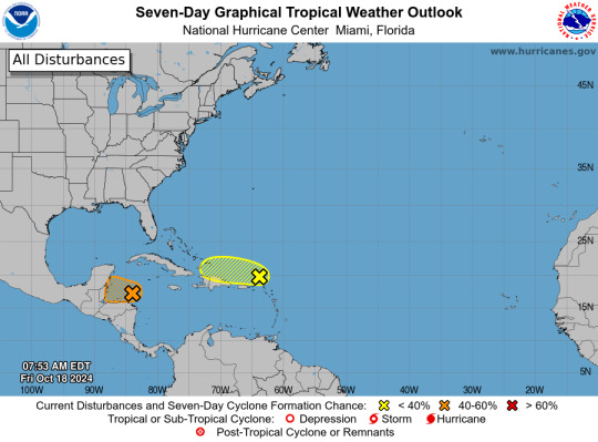
North of Puerto Rico and the Virgin Islands (AL94): A trough of low pressure is producing disorganized showers and thunderstorms extending a couple hundred miles north of Puerto Rico and the Virgin Islands. Development, if any, of this disturbance should be slow to occur while it moves quickly westward to west-northwestward at around 20 mph, continuing north of Puerto Rico and the Virgin Islands today, then near Hispaniola and the southeastern Bahamas this weekend. Further development is not expected due to strong upper-level winds by early next week.
* Formation chance through 48 hours...low...10 percent.
* Formation chance through 7 days...low...10 percent.
Western Caribbean Sea (AL95): Widespread showers and thunderstorms continue across the northwestern Caribbean Sea in association with a broad area of low pressure that is gradually becoming better defined to the north of eastern Honduras. Environmental conditions appear conducive for some additional development over the next day or so, and a short-lived tropical depression or storm could form before the system moves inland over Belize and the Yucatan Peninsula of Mexico on Saturday. Regardless of development, locally heavy rainfall is likely across portions of Central America and southern Mexico through the weekend.
* Formation chance through 48 hours...medium...50 percent.
* Formation chance through 7 days...medium...50 percent.
$$ Forecaster Hogsett/Cangialosi
#bot post#meteorology#weather#tropical weather#tropical storm#tropical depression#hurricane#atlantic#atlantic ocean#caribbean#gulf of mexico#noaa#national oceanic and atmospheric administration#nhc#national hurricane center
2 notes
·
View notes
Text
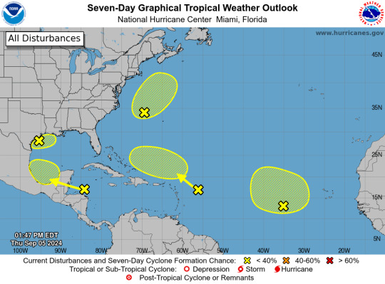
ZCZC MIATWOAT ALL
TTAA00 KNHC DDHHMM
Tropical Weather Outlook
NWS National Hurricane Center Miami FL
200 PM EDT Thu Sep 5 2024
For the North Atlantic...Caribbean Sea and the Gulf of Mexico:
1. Northwest Gulf of Mexico:
A large area of showers and thunderstorms continue in association
with a broad area of low pressure interacting with a weak frontal
boundary located over the northwestern Gulf of Mexico. Upper-level
winds are expected to become less conducive for development by late
Friday and Saturday as another frontal boundary approaches the
system. Although development is unlikely, heavy rainfall is
expected across portions of the northern Gulf Coast during the next
day or so. Additional information on this system can be found in
products issued by your local National Weather Service Forecast
Office.
* Formation chance through 48 hours...low...10 percent.
* Formation chance through 7 days...low...10 percent.
2. Northwestern Atlantic (AL99):
Showers and thunderstorms have become better organized in
association with a non-tropical area of low pressure located a few
hundred miles east of North Carolina, and recent satellite data
indicates the system is producing winds to near gale-force. This
system could acquire some tropical or subtropical characteristics
over the next day or two while it moves generally
north-northeastward, remaining offshore of the northeastern United
States. Once the low moves over cooler waters by early Saturday,
further development is not expected. Additional information on this
system, including gale warnings, can be found in High Seas Forecasts
issued by the National Weather Service.
* Formation chance through 48 hours...low...30 percent.
* Formation chance through 7 days...low...30 percent.
3. Eastern Tropical Atlantic:
An elongated trough of low pressure over the eastern tropical
Atlantic is producing limited shower activity. Development is not
expected through this weekend while the system moves little. Some
slow development appears possible early next week when the
disturbance begins moving slowly northwestward.
* Formation chance through 48 hours...low...near 0 percent.
* Formation chance through 7 days...low...20 percent.
4. Northwestern Caribbean Sea and Southwestern Gulf of Mexico:
Shower and thunderstorm activity remains disorganized in
association with a westward-moving tropical wave located over the
western Caribbean Sea. Development is not expected before the
system reaches Belize and the Yucatan Peninsula by early Friday.
Some gradual development is possible late in the weekend into early
next week after the system emerges over the southwestern Gulf of
Mexico.
* Formation chance through 48 hours...low...near 0 percent.
* Formation chance through 7 days...low...20 percent.
5. Central Tropical Atlantic:
Another tropical wave located a few hundred miles east of the
Leeward Islands is producing limited shower and thunderstorm
activity. Strong upper-level winds are expected to inhibit
development of this system during the next few days while it moves
west-northwestward at 10 to 15 mph. By early next week,
environmental conditions could become more conducive for some slow
development while the system moves over the southwestern Atlantic
Ocean.
* Formation chance through 48 hours...low...near 0 percent.
* Formation chance through 7 days...low...10 percent.
High Seas Forecasts are issued by the National Weather Service
under AWIPS header NFDHSFAT1 and WMO header FZNT01 KWBC, and online
at ocean.weather.gov/shtml/NFDHSFAT1.php
Forecaster Hagen/Delgado
2 notes
·
View notes
Video
youtube
Beautiful Herd of Horses Running Free! The icy Yukon Highlands, the verdant forests of Belize, the snow-capped peaks of the Rocky Mountains, and the barren deserts of the American Southwest are regions where the brutal law of natural selection is at work. The hostile weather and extremely difficult terrain mean that only the strongest and smartest creatures will survive in these places in the world
15 notes
·
View notes
Text
Anyway, a little more on climate change, from the perspective of someone who spent most of her life outside the United States.
I mentioned in another post that I grew up in the tropics, and spent most of my life absolutely HATING it, and wishing that I was living in the states. My brother is the opposite of me in that regard...he's always been happy in Belize and has no plans of leaving.
As such, whenever I complain about the weather when we chat on Skype, he says, kind of smugly, 'Well, you're the one who wanted four seasons!'
Yes. Yes I did.
I did want four seasons, my whole life in the tropics, and that hasn't changed.
I did, and STILL want, four seasons, not just the monotonous 'wet' and 'dry' I had in Belize.
But now that I'm finally living in a place where I can have four seasons, (as in, living living, not just going to school), climate change has messed things up so much that I don't even have a FULL four seasons anymore. At least, not in the way I would have liked.
I didn't have a snowy Christmas this last holiday season, like I would have wanted.
A couple of weeks after December we're FINALLY getting snow, but the temperature is so low now that I've been having to get rides to and from work because it's negative celsius out, and it is legitimately DANGEROUS to be outside for more than a few minutes.
So yes. I want four seasons.
I just wish that the climate hadn't messed things up, so I could actually ENJOY it.
#rhys-ravenfeather signing on#climate change#i definitely plan to talk to my brother about this next time we chat...
4 notes
·
View notes
Text

February recap: started the month off hot by running and walking everyday while on vacation in Belize 😎. After that I fell off the map with cardio and switched to kettlebell flows 2-3x’s a week. I’m ready for warm weather runs on the east coast 😩, call it an indoor riding and running slump that I’ll soon shake. I’m still getting my steps it so that counts right? On a positive note, my doctor’s checkup went well and all my levels were good.

5 notes
·
View notes
Text
Indiana Wants Me
Tuesday, October 10, 2023
We are big thinkers, we are. Continental scale, even.
We are headed across the continent to see an annular eclipse that, depending on the weather, may or may not be visible at our target destination, Piñon Mesa in Farmington, New Mexico.
An annular eclipse is when the disc of the moon blocks most, but not all of the Sun. The result is a "ring of fire."

When the left edge of the moon touches the left edge of the sun (or right touches right) it is possible to see Bailey's Beads. This is when the sun just barely shines between mountains on the moon, resulting in a sparkling effect sometimes called the "diamond ring."
The path of the eclipse goes from Oregon through Nevada, Utah, New Mexico, and Texas. And then almost straight down Central America before curving East across South America from Columbia through Brazil. Jeanne’s brother might see it in Belize. Thank you for coming to my TED talk.
We don't have the option to drive to Belize on this trip, so it's gonna hafta be either New Mexico or Texas, depending on the weather. We find a 7-day cloud cover forecast website (https://weatherstreet.com/states/u-s-cloud-cover-forecast.htm). Tim mutters about how imprecise the cloud cover forecast is for someplace half a continent away and six days hence. Actually, the Internet is a pretty impressive place to even have such information. We agree to keep an eye on it as we drive West, and not to decide until we get to Tim's nephew's house outside of Kansas City on Wednesday.
A note about I-70 through Indiana: it sucks. Ohio and Illinois have well-maintained roads. But in between, we entered Indiana with a bump, and the road surface stayed poor the whole way across the state. Jeanne had been leading a conference call. Her mouse started bouncing so badly she had to hand off the lead, and focus on the horizon to keep from getting carsick. And the horizon was filled with ugly billboards. Indiana, whatever you're selling, we ain't buying.
We stop for the night at an RV parking area for the Cumberland Covered bridge. It’s a long wooden covered bridge built in 2001. It won awards, but we have no idea why someone would build a covered bridge outside of New England tourist towns.


After dinner, we sit outside in the warm sun. A freight train thunders by barely visible through the trees. It’s unintentional, but there seems to be a theme developing about historic canals, historic roads and covered bridges, and the persistence of America’s freight train traffic.
2 notes
·
View notes
Text

Is this amphibian a visitor from outer space? 🛸 Nope… it’s the Yucatan casque-headed tree frog (Triprion petasatus), a species that can be found in parts of Mexico, Belize, and Guatemala. How does it put its head to use? When the weather is dry, this frog has been observed nestling into tree holes. It plugs the opening with its hard head, using it as a barrier against the outside world. This is thought to help the frog retain extra moisture in its skin!
Photo: marcoalp, CC BY-NC 4.0, iNaturalist
#science#nature#natural history#animals#frog#amphibia#amphibian#yucatan#cool animals#animal facts#did you know#fact of the day#herpetology
1K notes
·
View notes
Text
Cruise from Galveston
Dreaming of escaping to the Caribbean, Mexico, or beyond without the hassle of long flights or cross-country drives? A cruise from Galveston is your ticket to convenience, tropical adventure, and luxury—all in one. Situated on the Texas Gulf Coast, Galveston has emerged as one of the top U.S. cruise departure ports, combining charm, accessibility, and seamless connections to some of the world’s most desirable destinations.
When you book your cruise from Galveston with Luxury Cruise Trips, you gain access to expert-level travel planning, luxury perks, and tailor-made itineraries that go beyond the ordinary. Whether you’re a first-time cruiser or a seasoned traveler seeking an elevated experience, this guide covers everything you need to know.

Why Choose a Cruise from Galveston?
Choosing a cruises from new Orleans offers several compelling advantages for travelers looking for both comfort and class:
1. Strategic Location
Galveston is conveniently located near Houston, with two major airports (IAH and HOU) offering easy access from anywhere in the country. Whether you’re driving in from Texas or flying in for your vacation, getting to your cruise is effortless.
2. Year-Round Tropical Sailings
Cruises from Galveston operate year-round thanks to the region’s warm weather and proximity to the Caribbean and Gulf of Mexico. This means flexibility for your travel plans—whether you want a winter escape, summer break, or fall getaway.
3. Wide Variety of Cruise Options
From 4-day quick escapes to 14-day explorations, you’ll find a cruise from Galveston that fits your schedule and style. Major cruise lines operate out of the port, offering everything from family-friendly fun to adult-only luxury.
Top Destinations from a Cruise from Galveston
When you book a cruise from Galveston 2025, your itinerary might include vibrant cultures, exotic beaches, and rich historical landmarks. Here are some popular destinations:
● Western Caribbean
Experience places like Cozumel, Grand Cayman, Jamaica, and Belize. These ports offer a perfect mix of beach relaxation, diving, ruins, and adventure.
● Eastern Caribbean
Sail to destinations like St. Maarten, St. Thomas, Puerto Rico, and the Virgin Islands. These cruises from Galveston are often longer and offer a more immersive island experience.
● Mexico (Yucatán Peninsula)
Perfect for shorter getaways, cruises to Mexico include ports like Progreso and Costa Maya. Explore Mayan ruins, swim in cenotes, or relax by the turquoise sea.
● Panama Canal (Seasonal)
Some longer sailings include full or partial Panama Canal transits—ideal for cruise enthusiasts who enjoy unique maritime experiences.
Cruise Lines Operating from Galveston
Several world-renowned cruise lines depart from Galveston, offering luxury accommodations and world-class service:
● Royal Caribbean International
Their Oasis-class ships bring mega-ship luxury to Galveston. Expect Broadway-style shows, fine dining, and thrilling onboard activities.
● Carnival Cruise Line
Ideal for value-conscious travelers, Carnival offers fun-focused cruises with a laid-back vibe, plentiful food, and lively nightlife.
● Princess Cruises
Princess brings refined elegance with their alaska cruise from seattle options, offering culinary excellence, cultural enrichment, and spa wellness at sea.
● Norwegian Cruise Line (NCL)
NCL’s freestyle cruising model gives travelers the flexibility to dine and explore on their own terms.
● Disney Cruise Line
Perfect for families, Disney sails seasonally from Galveston with magical onboard experiences, kids’ clubs, and visits to Disney’s private island.
● Celebrity Cruises (Coming Soon)
Celebrity plans to expand into Galveston, bringing their Edge-class modern luxury experiences to Texas cruisers.
Elevate Your Experience with Luxury Cruise Trips
Booking your cruise from Galveston 2026 with Luxury Cruise Trips unlocks far more than a standard vacation. As a concierge-style cruise planning service, Luxury Cruise Trips ensures every part of your journey is seamless, stylish, and unforgettable.
Why Choose Luxury Cruise Trips?
● Personalized Cruise Planning
Their advisors don’t just book trips—they design experiences. From understanding your travel goals to selecting the perfect cruise line, stateroom, and itinerary, they offer a fully customized approach.
● Exclusive Perks & Amenities
Thanks to their preferred partnerships with top cruise lines, Luxury Cruise Trips clients enjoy:
Complimentary onboard credits
Cabin upgrades
VIP shore excursions
Early access to limited sailings
Fare discounts and limited-time promotions
● End-to-End Support
They handle it all—from booking pre-cruise hotels in Galveston or Houston to arranging airport transfers, insurance, and excursions. You’ll have a single point of contact for every detail.
● Expertise in Luxury Cruises
While cruises from Galveston include a range of lines and styles, Luxury Cruise Trips specializes in premium and luxury travel. If you seek gourmet dining, spa indulgence, cultural immersion, and personalized service, this is the team to trust.

Popular Cruise from Galveston Itineraries in 2025–2026
Looking ahead to future luxury vacations? Here are some premium alaska cruise from vancouver options to watch:
7-Night Western Caribbean with Royal Caribbean – Sail aboard Harmony of the Seas or Allure of the Seas to Cozumel, Roatán, and Costa Maya. Features include specialty dining and spa services.
10-Night Caribbean with Princess Cruises – Visit the Dominican Republic, St. Kitts, and St. Thomas with a focus on immersive excursions and refined service.
5-Night Mexico Getaway with Norwegian – Explore Cozumel and Progreso with flexible dining and entertainment options.
Each of these can be booked and customized through Luxury Cruise Trips, ensuring you receive added benefits and flawless service.
Tips for Booking Your Cruise from Galveston
● Arrive Early
Plan to arrive in Galveston a day before your cruise. It helps you avoid last-minute delays and gives you a chance to explore the charming town, its beaches, and the historic Strand District.
● Choose the Right Cabin
Balcony rooms and suites are great for Gulf views and added comfort. Let your cruise advisor help match your preferences to the ideal accommodation.
● Book Shore Excursions in Advance
Popular tours sell out quickly. With Luxury Cruise Trips, you can book private, guided experiences before you sail.
● Opt for Travel Insurance
Protect your trip against cancellations, medical emergencies, and lost luggage. Luxury Cruise Trips can bundle coverage into your booking.
Cruise from Galveston in Style
A cruise from Galveston offers so much more than convenience—it’s a launchpad for luxurious experiences across the Caribbean, Mexico, and beyond. From the moment you arrive at the port to the day you disembark, every moment should be marked by comfort, class, and ease.
With the help of Luxury Cruise Trips, you can transform your standard cruise into a tailored escape filled with exclusive amenities and first-class planning.
Start Your Journey Today
🌐 Visit: https://luxurycruisetrips.com 🎯 Premium Service | Concierge Planning | Exclusive Perks
Let the experts handle every detail of your cruises from los angeles—so you can relax, explore, and sail in style.
#Cruise from Galveston#cruises from new orleans#alaska cruise from seattle#alaska cruise from vancouver#cruises from los angeles
0 notes
Text
Why Is Central America Built for Travelers, Not Tourists?
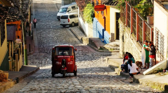
Central America refuses simple definitions. It is a region stitched together by landscapes that shift without warning: volcanic peaks, low-slung beaches, dense jungles, and ruins worn quiet by time.
Stretching from Guatemala to Panama, passing through Belize, Honduras, El Salvador, Nicaragua, and Costa Rica, the countries each carry a different weight, but travel here has a common pace. It rewards those who move without hurry.
Once you arrive, distance becomes irrelevant. Roads bend around hills, buses idle at mango-strewn markets, and the days lean into one another. Nothing rushes here, and that is the point.
Central America meets travelers on its own terms. Pay attention, and it offers something back.
The backbone of travel across the region is the bus. Buses are everywhere: affordable, familiar, and remarkably reliable. They are not built for comfort, but they are built for the road.
The most recognizable are the chicken buses, old American school buses reborn in bright colors and loud music, packed with passengers and life. They carry more than people; they carry the pulse of daily travel.
For quieter journeys, direct buses and shared shuttles move between popular hubs like Antigua and Lake Atitlán. They are easy to book through hotels or local operators, offering fewer stops and more space.
Renting a car opens a different version of the map: waterfalls at sunrise, beaches without signs, small towns where tamales are sold from unmarked stalls. But the freedom comes with caution. Roads can disappear without notice, signs are rare, and night driving is best avoided. Border crossings are mostly restricted. In cities like Panama City, San José, and Guatemala City, Uber is reliable; elsewhere, tuk-tuks and informal taxis fill the gaps.
For covering distance quickly, budget airlines like Avianca, Copa, and Spirit connect the region’s capitals. From outside Central America, flights from Miami, Houston, and Atlanta are frequent and often less expensive than flying to South America.
Ferries and boats fill in where the roads end. Belize runs regular ferries to Caye Caulker and Ambergris Caye. In Honduras, ferries cross to Roatán from La Ceiba. Around Lake Atitlán and Nicaragua’s Corn Islands, small boats can be hired directly. Schedules are flexible at best, but no one here measures time too closely.
The dry season, from December to April, brings clear skies and steady transport. It also brings crowds, especially in December and January when beaches and parks fill quickly.
The rainy season runs from May to October, usually with afternoon storms. The landscape shifts: greener, quieter, less hurried. Travel costs drop. May and November offer a balance with fewer tourists, decent weather.
Central America’s festivals do not gather around one grand celebration. Instead, they unfold locally. In Antigua, Guatemala, Semana Santa covers streets in colorful sawdust carpets. Carnival in Panama’s Las Tablas brings days of parades and water fights. Belize’s Garifuna Settlement Day and the region’s Fiestas Patrias in September celebrate independence with quieter pride. Día de los Muertos in Guatemala remembers the past with ceremonies more intimate than spectacular.
Safety across the region is uneven. Tourist areas tend to be secure, but petty crimes like bag snatching, pickpocketing are common enough to warrant attention. It is better to move with care: keep an eye on your belongings, avoid night buses, stay alert in crowds.
Solo travelers are not unusual. Even women traveling alone find Central America manageable with caution. Registered taxis, well-located hotels, modest dress, and local tours for day trips are standard practices. The region is welcoming, but caution belongs alongside curiosity.
Currencies change quickly. Panama and El Salvador use the U.S. dollar. Elsewhere, local currencies — the Costa Rican colón, the Guatemalan quetzal, the Honduran lempira take over. Cash is essential outside cities. ATMs are common, but it is smart to notify your bank ahead of time.
Central America remains affordable compared to Europe or Asia. Buses, guesthouses, and street food keep daily costs low. Luxury hotels and resorts exist but rarely dominate the travel landscape.
Food here is straightforward. In El Salvador, pupusas are griddled by hand and served hot. Costa Rica and Nicaragua share gallo pinto, rice, and beans cooked together until they lose their edges. Belize’s ceviche tastes clean and sharp along the coast. Tostones, crisped plantains, show up at roadside stands. Tamales, steamed and wrapped in banana leaves, are sold at bus stops. Meals are direct and satisfying, where flavors are shaped by place, not presentation.
Central America’s scale suits thoughtful planning. A loop from Guatemala south through Honduras, Nicaragua, and Costa Rica, ending in Panama, keeps movement efficient without feeling rushed. Two weeks can trace the arc of a few countries. A month allows enough time for the journey to stretch out.
Packing is simple: a carry-on bag, layers for both heat and cool, shoes ready for uneven streets, and a rain jacket against quick storms.
In the bus terminals and along the side streets, the gear that lasts is the kind designed for use, not attention. The canvas-and-leather builds from Rare Klub are built for distance. Quiet, durable, and ready for places where the pavement ends and the road becomes dusty.
Travel here is not about collecting landmarks. It is about moving slowly enough to see the space between them. Central America does not ask for speed. It asks for time.
#rareklub#america#usa#travelbags#bags for women#bags#bags & purses#bagstyle#fashionbags#designer bags#duffle bag#gymbag#laptop bags#blog#trending#carryonbag#carry on#fashion#central america
0 notes
Text
Top Overwater Bungalows in the Caribbean for a Dreamy Getaway
Have you ever dreamed of waking up to the gentle sound of waves beneath your feet, sunlight dancing on turquoise waters, and the sweet ocean breeze whispering through your private deck? Yeah, us too. There's just something magical about staying in an overwater bungalow—it feels like living in a postcard.
When most people think of overwater bungalows, their minds go straight to the Maldives or Bora Bora. But guess what? You don’t have to travel halfway around the world to experience that dreamy vibe. The Caribbean has its own slice of paradise, and it's closer than you think.
So if you're itching for a tropical escape, cocktails in hand, and toes dipped in crystal-clear water, here are the top overwater bungalows in the Caribbean that will blow your flip-flops off.
You can also explore more luxury with overwater bungalows Caribbeane options in curated boutique resorts that put privacy and personalization front and center.
Why Choose Overwater Bungalows in the Caribbean?
Let’s be real: hotel rooms are cool, but floating villas? That’s another level. Here’s why overwater stays in the Caribbean hit different:
Proximity: It’s just a few hours from the U.S., making it super accessible for a long weekend or a quick romantic getaway.
Weather: Sunshine and 80-degree waters—what’s not to love?
Luxury: Most of these spots are all-inclusive and adults-only. Translation: peace, privacy, and pampering.

Best Overwater Bungalows in the Caribbean
Ready to dive in? (Pun totally intended.) Let’s explore the absolute best places to stay when you want that overwater luxury without flying to the other side of the globe.
1. Sandals South Coast – Jamaica
If you're after all-inclusive luxury, Sandals South Coast is calling your name. Located on Jamaica’s unspoiled southern coastline, this resort features Over-the-Water Honeymoon Butler Bungalows that redefine romance.
Why you’ll love it:
Private infinity plunge pool
Glass floor panels to spy on tropical fish
Butler service with 24/7 room service
Hammocks suspended over the sea
This place is made for honeymooners, anniversary celebrations, or just because you deserve something fancy.
2. Royalton Antigua – Antigua
Modern, sleek, and ultra-luxe, the Overwater Bungalows at Royalton Antigua offer an elevated experience in a private cove. It's one of the few resorts in the Caribbean with this level of sophistication.
Highlights include:
Swim-out access to the sea
Personal infinity pool
In-room aromatherapy and pillow menu
Butler service and gourmet dining
These bungalows are adults-only, so you can enjoy peace, quiet, and all the romance your heart can handle.
3. Aruba Ocean Villas – Aruba
Want something a little more boutique and laid-back? Aruba Ocean Villas might be your match made in island heaven. With just a handful of overwater villas, it’s intimate, artsy, and packed with charm.
What sets it apart:
Rustic-chic decor and island vibes
Private outdoor bathtubs and hanging daybeds
Located in the sleepy fishing town of Savaneta
Personalized service with a family-run feel
This spot is perfect for travelers who want something less commercial and more authentic.
4. Thatch Caye Resort – Belize
If you’re craving an off-the-grid adventure with just the right amount of comfort, Thatch Caye is your jam. Located on a private island off the coast of Belize, this eco-resort offers overwater bungalows that feel completely disconnected from the world—in the best way possible.
Perks to expect:
Sustainability-focused resort
Open-air bungalows with sea breezes instead of A/C
All-inclusive meals and island-inspired cocktails
Snorkeling, paddleboarding, and island hopping at your fingertips
Looking for a digital detox? This is your paradise.
5. Palafitos at El Dorado Maroma – Mexico (Riviera Maya)
Okay, technically not in the Caribbean islands, but nestled on the Caribbean coast of Mexico. So it totally counts, right? Palafitos at El Dorado Maroma offers overwater bungalows that scream opulence.
Here’s why people can’t stop raving:
Glass-bottom floors and private decks
Personalized beach picnics and spa treatments
Gourmet dining (hello, lobster tacos!)
Steps away from one of the world's best beaches
If you're looking to splurge and be treated like royalty, this is the one.
What’s So Special About These Caribbean Bungalows?
Each location has its own flair, but they all bring the dream of overwater living to life. From barefoot luxury to ultra-modern design, there’s something for every traveler.
Some are ultra-private, others are buzzing with activities, and a few focus on eco-conscious luxury. But all of them offer front-row seats to sunrise views, clear waters, and that sweet, slow island life.
By the way, if you're planning a trip soon, check out these boldly breathtaking spots for overwater bungalows Caribbeane—they'll make you want to book that flight tonight.
And while you're daydreaming, don’t forget the off-the-beaten-path options like Aruba Ocean Villas or Thatch Caye, which offer a different kind of vibe—more rustic, more relaxed, but just as beautiful.
Tips Before You Book Your Dream Bungalow
Booking an overwater bungalow in the Caribbean isn’t quite like reserving a regular room. Here’s a quick cheat sheet:
Book Early
These villas are limited and fill up fast—especially during peak travel seasons (think winter and spring breaks).
Check What’s Included
Some are all-inclusive, others aren't. Make sure you know what’s covered—meals, transfers, activities, etc.
Mind the Weather
The Caribbean does have a hurricane season (June to November). Prices might drop during this time, but it’s a gamble. Consider travel insurance if you're going this route.
Pack Light, But Smart
Don’t forget reef-safe sunscreen, water shoes, and a waterproof camera. Oh, and maybe a few extra swimsuits—you'll basically live in them.
Final Thoughts: Your Dreamy Overwater Escape Awaits
So, there you have it—some of the most stunning overwater bungalows in the Caribbean that offer the kind of escape we all need from time to time. Whether you want high-end pampering or a quiet, off-grid retreat, the Caribbean has something for you.
And the best part? You don’t have to cross oceans to get there. Paradise is just a short flight away.
Ready to make some waves?
0 notes
Text
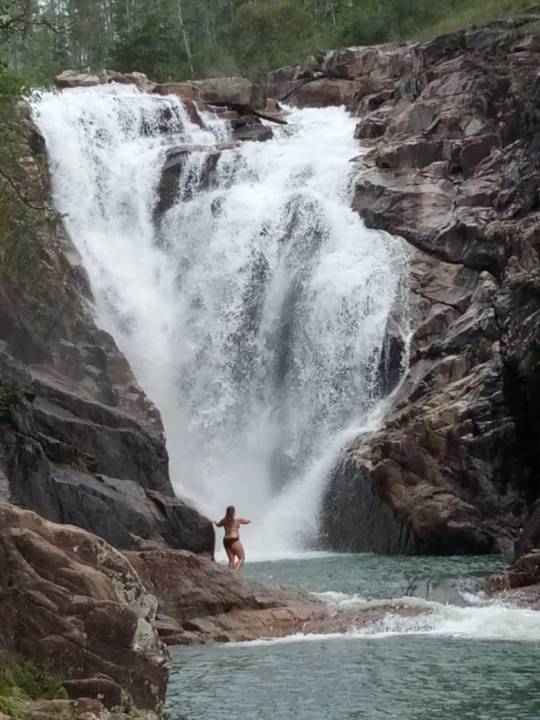
Hot weather calls for refreshing waters!
Big Rock Waterfalls
0 notes