#valleymeet
Explore tagged Tumblr posts
Visit Tumblr Blog
Explore Tumblr blogs with no restrictions, modern design and the best experience.
Last Seen Tumblr Blogs


Fun Fact
130K people were victims of a chain letter scam that affected Tumblr in May 2011.
Text


In sunlight and moonlight
#cor plays hzd#currently replaying hzd and had to take pretty pictures of the blorbo#horizon zero dawn#hzd#hzd photomode#nil#hzd nil#location: the valleymeet
58 notes
·
View notes
Text
Shock Trial: Stun Bellowbacks and Shoot Canisters off the Undersides.
Blazing Sun awarded.
#horizon: zero dawn#horizon#zero dawn#aloy#ashly burch#shock trial#stun bellowbacks and shoot canisters off the undersides#blazing sun#valleymeet hunting grounds#hunting grounds trials
1 note
·
View note
Text
Spurflints Keeper: You can't hunt stalkers with brute force. You have to use patience.
Me, an idiot with an improved Stormslinger: Bet
#horizon games#hzd#raven plays hzd#i can; will; and am brute forcing these hunting ground trials when possible tyvm#listen the icethrower was SUPER EFFECTIVE at valleymeet and the stormslinger was just as (if not more) useful at spurflints#the if not more being i didnt blow up a stalker at point blank range like i accidentally did that one bellowback
0 notes
Text


Valleymeet
#horizon zero dawn#hzd photomode#hzd remaster#beloved hut besieged by not-so-beloved shellwalkers#or shellwalker?#some part of my brain insists there were two#at the time of taking these pics there was only one#but then again my hzd skills have suffered terribly since 2021#so i'm currently playing a ng on easy#while my regular photo mode run was a ng+ on uh#well. maybe i'll get there again#yesterday i loaded up an old save without checking the difficulty first#and ran down a ravine to check something#and wondered why there were so many machines all intent on making my life more miserable#....turned out the save was on hard. welp
12 notes
·
View notes
Text
For those that are curious, this is the Real World Horizon location map that Count uses, done by jesuscuervo on Reddit.
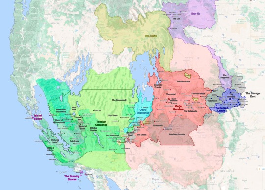
See under the cut for more information.
Real World Horizon Map (Speculative)
The Embrace proper is just the valleys and lakes between Pike’s Peak and Cheyenne Mountain, the core of the Nora Territory. Here, I placed each village in a valley respective to the location of Cheyenne Mountain but moved a few things around so it would not be too crowded.
The Outer Sacred Lands – outside the Embrace proper – contain several outcast camps. I had the Nora Territory expand across the Grand Mesa and Gunnison National Forest. Brom’s Camp is located over the Black Canyon of the Gunnison as it is depicted in-game, while Rost’s Hovel and Grata’s Camp are located on the hills/mountains closer to the Embrace.
Valleymeet; the neutral land between The Sacred Lands and the Carja Sundom is based on Maroon Bells, CO in-game. However, I mapped it out to include all of the White River National Forest within Valleymeet.
Hunter’s Gathering the main settlement in Valleymeet would likely be would be located on the Roaring Fork Valley near Woody Creek. That is the largest open valley in the area and the path through which the present-day CO-82 passes could work as a main throughway between the Nora and Carja lands.
Shivering Watch, following CO-82 the mountains narrow into a canyon south of Glenwood Springs (not Glenwood Canyon). The canyon acts as the chokepoint and border between the formerly Nora lands and the Carja Sundom where Shivering Watch and The Daytower are located.
Two Teeth Camp is depicted as being on Maroon Peak in-game. However, it is built over the ruins of the Smuggler-Union Hydroelectric Plant, which is further south in Telluride, CO. I kept Two-Teeth in the southern location so it acts as a second buffer between the Sacred Lands and the Sundom.
The Carja Sundom; is where the game took the greatest artistic liberty. The game depicts the heartland of the Carja Sundom south of the Colorado River (Lake Powell specifically); however the real-world locations depicted within The Sundom, the area its geography is based on (Eagle Canyon, Arches, and Canyonlands National Parks), and the route Alloy travels through suggests the Sundom is actually located north of the Colorado River in the real world. Thus rather than having the Sundom’s heartland located in the Colorado Mesa, it would make more sense to place it in the already fertile Price and Green River Valleys in Utah. This way I was able to keep Meridian in Eagle Canyon and Sunfall in Bryce Canyon. Thus Sunfall is actually southwest rather than northwest of Meridian. The Carja Sundom would extend across most of the Western Slope in Colorado into most of eastern and southern Utah. With Shatter Kiln (Provo) as its northernmost boundary.
The Sun-Steps – are the first region of the Sundom that Alloy encounters on her journey. In-game it stretches from Arches National Park to what appears to be Horseshoe Bend. However, Horseshoe Bend is too far south for it to make sense as the border, so I have Morning Watch located further north on another bend. Since river bends can form anywhere it is not a stretch to think there is a new bend somewhere else. Over all the Sun-Steps correspond to the Grand Valley in CO.
Free Heap – located within the Sun Steps is Free Heap, an Oseram outpost set up to provide construction material for Meridian. If they are mining for industrial materials from the Old Ones, it would make the most sense for Free Heap to be located on or near Grand Junction CO, which is the largest settlement in the area today.
Gatelands – form the eastern half of the central Carja Sundom. Unlike the rest of the Sundom, this region is relatively easy to map out since most locations have an obvious real-world reference corresponding to Arches and Canyonlands National Parks.
Lone Light had to be relocated since Horseshoe Bend is much further downriver in reality. I placed it in a smaller bend upriver.
Gatelands Bandit Camp - I depicted the Bandint Camps as neutral/independent enclaves within the Sundom, the Gatelands Camp being the largest one of these and corresponding to the entirety of Arches National Park.
The Jewel – the central heartland of the Carja Sundom appears to be based on Monument Valley in present-day Utah and Arizona. However this location would be rather out of the way from Aloy’s journey and it doesn’t fit some of the locations depicted within the Jewel itself (mainly Meridian, which is located in Eagle Canyon). Thus, I thought it made more sense for it to be centered on the eastern Green River Basin along the present-day Carbon, Emery, and Wayne counties. This way Meridian remains in Eagle Canyon and the Spurflints in the San Rafael Reef. The Spearshafts would be a new formation (not present today) somewhere in Canyonlands National Park.
Rustwatch – in-game the Shadow Carja territory is north of the Jewel across from Daybrink (Lake Powell), however since The Jewel is no longer located south of the Lake, Rustwatch and Sunfall are now southeast of the Carja heartland. But Sunfall keeps its location in Bryce Canyon.
The Southern Frontier – in-game Kestrel’s Perch is defined as a fortress built by the fifth Sun King Zavarad as the Sundom expanded north of Daybrink (Lake Powell) into Rustwatch. However because in the real world, Lake Powell is south of what I’ve defined as the Carja heartland, this frontier is now south of Daybrink and Rustwatch.
The Mountain Frontier – Call of the Mountain doesn’t really give many references on where Rising Light and the main route of the game are located, except that it is mountainous and – for the most part – densely wooded. So I opted for the Sundom to have a “Mountain Frontier” along the Wasatch Range. Because the world of Horizon is likely set in a warmer and wetter Earth (due to rising sea levels), the Bonneville and Lahontan Great Lakes have been resurrected east of this range. The former of these acts as The Sundom’s western border and provides the precipitation and rainfall necessary to create forests and jungles in the Colorado Plateau.
Shattered Kiln – a bandit camp near the northern reaches of the Sundom, as in-game it is based on Provo Utah near Maker’s End (Salt Lake City).
The Daunt; the southwestern corner of the Carja Sundom corresponds to Zion National Park. However, Zion is relatively small to fit all the in-game locations. In-game, Zion National Park appears to be the same size as the entirety of Southern Nevada or the California Central Valley. To fit everything in, I extended The Daunt to include the entire Virgin River Basin in Washington County Utah.
Barren Light would then be located with St George, Utah where the Virgin River (and the I-15) cross Bloomington Hills.
Chainscrape and the Redhew Quarry, the Oseram settlement within the Daunt is located along a bit upriver from Barren Light.
The Claim; the Oseram territory is not depicted in-game, however, Pitch Cliff and Free Heap are two Oseram settlements near their border with the Carja Sundom. It is stated that their territory is north of The Sundom and west of The Cut, so it likely corresponds to Idaho, specifically the Snake River Basin.
Pitch Cliff is likely located along the Roan Cliffs, and possibly very near the border between the Claim and the Sundom.
The lands between The Long Roam, the Claim, and the Carja Sundom form an unclaimed region around the present-day Uintah Basin. Oseram traders travel through it and the Carja might have sent some raiders across it, but it remains mostly unpopulated. I shaded this area pink as the Carja might claim it but likely hold no direct control.
No Man’s Land - is the border between the Carja Sundom and the Tenakth Clanlands. No Man’s Land borders are not well defined in-game, but they seem to correspond to the northern shore of Lake Mead, specifically the area around the Overton Arm where the Virgin River meets the Lake. The overall location works for a real-world equivalent, but a few things get shuffled around for them to fit.
Jagged Deep; the eastern bank of the Virgin River was tenuously controlled by the Carja Sundom. What remains is Riverwatch, an abandoned fort on the banks of the Overton Arm, and Jagged Deep an abandoned mine that is now delved by Oseram adventurers. The Carja Camp on the west bank of the Overton Arm is the furthest west Carja settlement.
Eastern Lie & Deadfalls are the westernmost Tenakth settlements closest to the Cajra and Utaru borders, which have been taken by Regalla’s Rebels. In fact, most of the Tenakth side of No Man’s Land is occupied by the rebels.
Spinebreak; in-game Spinebreak is located on the southeastern border between No-Man’s Land and the Tenakth Clanlands proper and built under the ruins of a present-day highway tunnel. The issue is that there are no tunnels – or logical places to put a tunnel – between the Overton Arm and Las Vegas (the Stillsands). I thus place Spinebreak further north on the Virgin River Canyon acting as a second border between Barren Light and the Tenakth camps.
The Utaru Tribal Lands; the Utaru settled in the lands surrounding the Western Grand Array (WGA), which they named Plainsong.
Plainsong, although the WGA is based on the Very Large Array in New Mexico, the VLA is very far from Aloy’s path and the in-game geography. Furthermore just like the Nora take their name from the NORAD Facility and the Tenakth take their name from the Tenth Task Force, I suspect the Utaru take their name from Utah. Thus it is likely that the WGA is not the VLA but rather a new array built somewhere in Southern Utah, between the Carja Sundom and the Desert Clans. With this in mind, I placed Plainsong on the Cedar Valley and worked from there.
Stone’s Echo – Stone’s Echo is an Utaru outpost near the Stillsands, just past No Man’s Land. I placed it along the Meadow Valley Wash, which would likely be a tad more fertile than in the present day. Because we are dealing with what I expect is a warmer and wetter climate due to rising sea levels (and AETHER’s supercell storms going haywire).
Riverhymn – On the northern edge of the Utaru lands lies Riverhymn; the second largest Utaru settlement after Plainsong. In-game it is located in a fairly mountainous corner. So it is likely located near Frisco Peak with the river that passes through it being the Beaver River. However this river flows in the opposite direction that is seen in-game, rather than flowing south towards Plainsong, it flows north into the Sevier Lake.
·Due to the wetter climate, it is possible that the entire Bonneville Basin is once again flooded and Lake Bonneville acts as a boundary between the Utaru, the Carja, the Oseram, and Tenakth Desert Clans but the game map does not go that far north. Regardless I thought it be cool so I opted to depict it as such.
Tenakth Desert Clans; the Desert Clans inhabit most of Southern Nevada. Their territory reaches the present-day Great Basin National Park in the northeast and the Shining Wastes (Death Valley National Park) to the West.
The Stillsands; southwest of the Utaru territory, is another semi-contested region (it is within the Tenakth Desert Clan territory but both major settlement Camp Nowhere and Hidden Ember are Oseram). This is pretty simple since it corresponds to Clark County NV, with Hidden Ember clearly being Las Vegas. I originally had Devil’s Grasp be located in Barstow CA, but opted to place it closer to Las Vegas in Primm.
Dry Yearn; is the easternmost region of the Clanlands. It contains Arrowhand, the second largest Desert Clan settlement, and Restless Weald. It is fairly easy to place since Restless Weald is based in Caliente, NV. With this in mind, I placed Arrowhand over Crystal Springs, NV, and the Dry Yearn Camp just north of Restless Weald.
The Greenswell; is the northernmost region of the Desert Clanlands; it is also the least arid region of the Desert Clans. Part of this can be attributed to the supercell storms, but I also opted to have the core of the territory within the Great Basin National Park, which is a very green area within the Nevada desert, which further explains the area’s climate.
Scalding Spear; centrally located in the Nevada desert, the capital of the Desert Clans is located on the present-day Crescent Dunes Solar Energy Project.
Shining Wastes; is an arid mostly flat expanse of land, which for the most part corresponds to Death Valley National Park. The only problem is that Death Valley is not particularly flat. I included Death Valley, now filled in with a saline lake, within the Shining Wastes but placed the main settlements located further north within the Nevada Desert (which is mostly flat).
Runner’s Wild – a small region in the Desert Clan territory, Runner’s Wild corresponds to Mammoth Lakes in California and acts as a border between the Desert and Sky Clans.
Salt Bite – north of Runner’s Wild this region borders Runner’s Wild and the Greenswell, it is clearly based on Mono Lake in California and the geography easily fits into this location.
Memorial Grove; although the Tenakth are divided into three warring Clans (and Regalla’s Rebels), the Memorial Grove acts as a capital / neutral ground for all three. The Grove is located on a museum and military base – specifically an airforce base – south of Mono Lake. The base does not exist in the present day but could be located anywhere in the Owens Valley. I paced it on Independence, CA (fitting name). Like other areas on the map, the Owens Valley is also much more fertile than in the current day.
Tenakth Sky Clans; northwest of the Memorial Grove the Sky Clans make their home along the Sierra Nevada, specifically Yosemite Valley and the Sierra National Forrest. Not many changes here, but it doesn’t seem like their territory expands much further north than Lake Tahoe (unless it is not depicted).
The Bulwark; the capital of the Skyclans is based on Sentinel Dome in Yosemite Valley, I kept it here and based the rest around it.
Sheerside Mountains; are based on the Sierra Nevada, the region itself corresponds to the northern half of the Sky Clans’ territory. I took Sheerside Climb to be the pass from Mammoth Lakes to Yosemite and assumed Bonewhite Tear and the other settlements would be located along CA Route 120 and the Tuolumne River.
Stand of the Sentinels the southern region of the Sky Clans appears to be based off the Sierra National Forest. Its major settlements follow a pass from Mammoth Lakes to Tide’s Reach (possibly Fresno CA, see below). This suggests that the major settlements are located along the San Joaquin River.
Tenakth Lowland Clans; like the Carja Sundom, the Lowland Clans pose a huge conundrum. The Lowlands seem to consist of the foothills of the Sierras along Kings Canyon National Park and the Sequoia National Forrest towards a coast. This suggests that California’s Central Valley is flooded due to rising sea levels. If this is the case it helps explain why The Long Coast (Bakersfield) is a coast and not inland.However, if this were the case there should be a long peninsula formed from California's Coastal Ranges. But this peninsula is completely absent from the in-game map. Furthermore, Tide’s Reach appears to be based in Oakland, but it is geographically located at the foothills of the Sierra National Forrest. This should be impossible; Oakland would be located on the aforementioned “peninsula” between San Francisco Bay and the “Central Valley Sea”, but this peninsula is nowhere to be found on the map.
I tried my best to come up with a creative solution.
Raintrace – as in-game Raintrace is based on Sequoia National Forrest, Lowland Path and Fall’s Edge are located along CA Route 180 and King’s Canyon, which provide a direct route from the Memorial Grove to the rest of the Lowland Clans’ territory. Fenrise is further south on Isabella Lake where the Kern River valley provides a connection between the Desert Clans and Lowland Clans’ territories.
Tide Reach – I relocated Tide’s Reach to Fresno, CA which is now along the coast of the “Central Valley Sea”. I opted to have it based on Fresno since it provides another large present-day settlement where to base it, and more importantly, it is directly on the path Alloy would take from Stand of the Sentinels. Since Alloy can’t swim from Tide’s Reach to the Isle of Spires (San Francisco) it makes sense to place it further away from the island than Oakland. SF Bay is large, but not large enough for there to be a storm that wrecks Alloy’s raft. To make the route Alloy takes a bit more logical I also broke up the Coastal Ranges north of the Salinas River into an archipelago. I considered sinking the entirety of the Mt Diablo Range, to provide a direct route from Tide’s Reach to the Island, but I thought that would be too much.
The Long Coast – in-game The Long Coast seems to refer to the Pacific Coast, but as already mentioned it also refers to the ruins of Bakersfield CA. Thankfully a flooded Central Valley means we’ve gained a new coast. Thus the Long Coast now refers to the western coast of this inland sea. Thornmash, in-game coordinates suggest it is located near Tracy, CA. but I placed it a little further south on this coast so it forms a triangle with Tide’s Rach and Raintrace Rise and so it is not too close to San Francisco.
Cliffs of the Cry – as in-game the Cliffs correspond to Big Sur and the California Pacific Coast. I opted to have Raintrace West located on the Cliffs (close to San Luis Obispo) since you travel from it to the Zennith Base.
Isle of Spires; is straightforward San Francisco, which is now an island. Alva describes San Francisco as an archipelago, so this helped me further justify the breakup of the Coastal Ranges. Although I realize that such geologic shifts would likely destroy the city of San Francisco itself. This is the suspension of disbelief in a world that has a volcano appear on Yellowstone and New Zealand sink beneath the waves.
Zenith Base; originally I thought about having it located in Monterey however it is south of Tilda’s Mansion, which is in Big Sur. It then seemed fitting to place the Zenith Base in Vandenberg Airforce Base instead.
The Burning Shores; it is LA, which like San Francisco is now an archipelago due to tectonic activity and rising sea levels. This is pretty much explained in-game.
Fleet’s End is located somewhere in the Baldwin Hills, which are now the main island of the “bay”
Pangea Park / Londra Productions is described as being on a peninsula. Because it is partially based on Dinseyland (or Universal Studios) I’ve opted to keep it in Anaheim. To make Anaheim a peninsula I’ve flooded the San Gabriel Valley in the north and Newport Beach in the south.
#aloy and seyka#aloy x seyka#horizon burning shores#horizon forbidden west#countdown#my writing#countdownfic#horizoncountdown#field guide
29 notes
·
View notes
Text
Day 11
The Sacred Lands


I rode toward Daytower just after dawn, but on the way I passed the Caldron that Dral spoke of: a huge triangular space carved out of the rock, giving way to a metal door. It was like a larger version of the door in All-Mother mountain, and the machines were trying to protect it.
I was running low on supplies, carrying around a lot of valuable junk too. I stopped by to trade with the merchant at the Valleymeet hunting grounds.


Back to the Caldron after that. The Corrupter's override module opened the door, all of it suggesting a common source, a language they all speak to one another.


Inside, the Caldron stretched out and down, burrowing deep. Looking into the depths of the chute, I wondered for a moment if Dral had been right—it certainly didn't seem like a hospitable place. It was only a moment.


The override module aided me many times on the way through. I didn’t even care that I might not make it out, couldn’t think of it, because it was so beautiful, a machine as big as a mountain—maybe that’s what All-Mother really is too. And the people that made them…maybe they’re behind the door.


There were machines inside, patrolling, protecting the larger machines that made them. I saw huge mechanical arms shaping components, stirring reservoirs of chillwater and blaze, saw seething cores of bright energy, flying machines towing canisters and shards. Why do they do it?


Onwards to the Caldron's core, where the signal was coming from. It was a huge dome of light, mechanical arms inside weaving the body of a Bellowback between arcs of blue glow.


I fought it, and when it was downed, the core of the Caldron rose up, red and misted in chill. Even that spoke to my override module, and the core lit up blue as the platform rose back up to the Caldron entrance. Convenient. Or is it like the bridges this place builds, some unspoken want that travels from my Focus to the module and into the machinery beyond? It reminds me of the way my Focus learns; as it listened, saw more through my eyes, it came to understand Nora runes, our names for the machines, even the names of people.
My override module updated as well; more machines that will follow me.


I set out across the valley into the late afternoon light, and came by Hunter's Gathering at dusk. Not much progress today in terms of distance, but I'm a little closer to understanding the forces behind the machines. Maybe I can find a way to teach my override module to clear the corruption, even quell the derangement of the machines.


I met a woman called Gera—friendly, forward, and she gave me a sip of Scrapper sap, bitter, felt it burning all the way down. Oseram like this stuff? She told me a little of the area and of the Claim. Women are property there, apparently. I don't really understand how someone could consider the one that brought them into the world less than a person—it makes even less sense than the Nora making leaders of old women who've carried the most kids. I'm glad I wasn't born an Oseram. I'm not sure if being owned is worse than being shunned, but at least I had a way out of my situation. Seems that for a lot of Oseram women their only escape is to leave the Claim altogether.


I climbed a trail just outside Hunter's Gathering toward a huge painting on the rock face, looked Banuk. I found a wooden figurine out there, expertly carved. The view was nice: a huddle of fire and distant voices against the mountain.


Spent the night there. Before sleep, I rested some and spoke to the Oseram, Carja and Banuk outlanders about their travels.
7 notes
·
View notes
Video
youtube
Horizon Zero Dawn Remastered Valleymeet Hunting Grounds All Gold Medals ...
0 notes
Text
There are so many story moments that are seared into my brain, as well as the first time I heard a Tallneck's footsteps, but there's another moment that particularly stands out for me. Since I connect with this game so much through photomode, I can not only tell you but recreate for you what that moment was!
First, lemme set the scene: it's late 2019/early 2020 and I'd just gotten a PS4 for Christmas. It was the first gaming system I'd owned since my PS2, and I hadn't played games in probably a decade. The PS4 came bundled with HZD, but I didn't know anything about it. I'd seen the cover art, and remember someone somewhere saying something positive about it once, but otherwise I went in completely blind.
The Moment was early in the game - I was still in Nora lands - at a time when I was almost positive this was postapocalyptic Earth (as opposed to another planet or something), but hadn't run across anything to confirm that 100%. I was exploring the area behind the Valleymeet Hunting Grounds. There's a hill, and I was running up it:

and I see a rusty wind turbine in the distance. I get a chill down my spine, because this has to be Earth, right? I get closer, and pause next to the turbine where I see a broken tree, which seemed ominous:

but then at the crest of the hill you can see a whole forest of decaying turbines:

I can't really describe the feeling it gave me. There's a feeling of desolation here, of loneliness, but it's beautiful. I could see for miles! I was already gripped by the need to find out what happened in the story, but at this moment I knew I'd be spending hours and hours crawling over every inch of this map.
I continued on down the hill until I saw something moving in the distance. I zoomed in with concentration, and:

approximation of my inner dialogue at that moment: WHAT. That thing is HUGE. That's the thing from the cover. I have to fight that at some point! There's a Watcher next to it and it's TINY! It's stomping around knocking down trees! Oh my god it's actually knocking down trees that is so COOL no wait NO IT'S NOT. IT IS NOT COOL! THAT THING IS SCARY!!!
And then I said aw HELLLLL no and hightailed it out of there back to whatever quest I was on.
So that was The Moment for me. I so appreciate all the work everyone at Guerrilla did for HZD - it was my reintroduction to games after a long hiatus, and I don't think anything has topped it yet. I'm not sure anything can.
Today is the seventh anniversary of Horizon Zero Dawn!
After a heartbreaking day yesterday for Guerrilla—in celebration of the game and in boundless thanks to the incredible folks whose passion and care brought it to life for us—reply or reblog with your favorite moment of, or memory of playing, HZD! 🏹🏹🏹
For me, it was my first time traversing the Bitter Climb. With the environment, the music, and the weight of the story, I felt so in tune with Aloy and the world that the experience was nearly out-of-body. It takes a special, powerful entity of creation to invoke that feeling.
#thanks for this post foibs!#sending good thoughts to all the guerrilla peeps <3#there were ... so many moments for me#actually the bitter climb is another one - even aside from the story that area gives me a similar vibe as the turbines. and the music !!!#also encountering the scorcher outside the cut#and fixing the frozen wilds tallneck#climbing maker's end#the grave-hoard#running through burning meridian#and on and on and on#long post#hzd
123 notes
·
View notes
Text
I would say the oseram are my favorite tribe then I remember all the oseram women in the valleymeet and the sundom and the forbidden west who had to leave the claim to pursue their careers bc they couldnt do it at home and suddenly I’m like……..yeah they kind of suck
#oseram#hzd#eli talks#I just love all the oseram I meet but theyre all the types to leave the claim so cant rly know what#the oseram men are like back home#also is the vanguard all men???
21 notes
·
View notes
Text
Horizon Zero Dawn - Missions (Timeline Order)
Okay! So I’ve always thought about how to do missions in video games so that it makes chronological sense. Like, how you can access a mission about a village on fire at the beginning of the game, come back to it after the final battle, and the village can still be saved. And one of my favorite games is Horizon: Zero Dawn! So here’s how I did the missions in my recent playthrough! ------------------------------------------------ - A Gift From The Past - Lesson’s From the Wild - Odd Grata - In Her Mother’s Footsteps - The Point of the Spear - Mother’s Heart - The Proving - The Womb of the Mountain - Insult to Injury - A Seeker at the Gates (up to Varl) - The War-Chief’s Trail (up to talking with the survivor) - Corrupted Zone: Sacred Land’s - Nora Hunting Grounds - Ancient Armory (access mission) - A Daughter’s Vengeance (access mission) - Tallneck: Devil’s Thirst - Devil’s Thirst Bandit Camp - The War-Chief’s Trail - Revenge of the Nora (access mission) - Sanctuary - Luck of the Hunt - Shortage of Supplies - A Seeker at the Gates (Up to Marea) - Corrupted Zone: Valleymeet - Valleymeet Hunting Grounds - To Old Acquaintances (access mission) - Underequipped - Cauldron SIGMA - Corrupted Zone: Red Echoes - Revenge of the Nora - Corrupted Zone: Forsaken Village - Corrupted Zone: South Valleymeet - Two-Teeth Bandit Camp - A Seeker at the Gates - A Daughter’s Vengeance (talk to Zaid) - In Foreign Lands - The City of the Sun (access mission) - Greatrun Hunting Grounds - Tallneck: Copper Deeps - Cauldron RHO - Gatelands Bandit Camp - Corrupted Zone: Gatelands - Tallneck: Sun Steps - A Daughter’s Vengeance - Blood on Stone - The City of the Sun - The Field of the Fallen (access mission) - Makers End (access mission) - Gets maps for all the collectables, does as missions continue - Fatal Inheritance - Demand and Supply - A Moment’s Peace (access mission) - The Field of the Fallen - Into the Borderlands (access mission) - Collateral - Cauldron ZETA - Corrupted Zone: Sun Furrows - Acquired Taste - Sun Furrows Hunting Ground - The Sun Shall Fall - Hunting for the Lodge - Hunter’s Blind - Deadliest Game (access mission) - A Curious Proposal (access mission) - Robbing the Rich - Honor the Fallen - Deadliest Game - Heap of Trouble - Death From the Skies - Hammer and Steel - Sunstone Rock - Blackwing Snag Bandit Camp - Sun’s Judgment - Sun and Shadow - Redmaw - Shattered Kiln Bandit Camp - Maker’s End - The Grave-Hoard (access mission) - Corrupted Zone: Maker’s End - Hollow Fort Bandit Camp - Cause for Concern (access mission) - A Moment’s Peace - The Grave-Hoard - To Curse the Darkness (access mission) - Tallneck: Spearshafts - Corrupted Zone: Spurflints - Spurflints Hunting Grounds - Cauldron XI - Corrupted Zone: Dusk Mesa - A Curious Proposal - To Curse the Darkness - Deep Secrets of the Earth (access mission) - Tallneck: Rustwash - Corrupted Zone: Rustwash - Deep Secrets of the Earth (until Vanasha talk) - Traitor’s Bounty - Healer’s Oath - Queen’s Gambit - Deep Secrets of the Earth - The Terror of the Sun - The Heart of the Nora - The Mountain that Fell (access mission) - Into The Frozen Wilds (until Burgrend) - Waterlogged (access mission) - A Secret Shared (access mission) - Tallneck: Frostfigures - Into the Frozen Wilds - The Shaman’s Path (access mission) - Waterlogged - Control Tower: Greycatch Lake - The Shaman’s Path - Control Tower: Shaman’s Path - Control Tower: Hollow Hall - Stone Yield Bandit Camp - The Survivor (access mission) - Snowchant’s Hunting Ground (first 2) - The Survivor - For the Werak - Firebreak (access mission) - Snowchant’s Hunting Ground (final trial) - Frontier Justice - The Hunter’s Three - Control Tower’s: Longnotch Valley - Geared Up (all 3 missions) - The Claw’s Beneath - Firebreak - The Forge of Winter - Out of the Forge - Ikrie’s Challenge - The Mountain that Fell - The Looming Shadow (access mission) - Ancient Armory - The Looming Shadow - The Face of Extinction ----------------------------------------------------------------------- This is just how I did it, but I tried to keep them relatively simple. How did you guys do yours? P.S. I’m also cataloguing the Forbidden West missions as I do my 2nd playthrough right now ;)
#Horizon Series#horizon zero dawn#horizon forbidden west#Aloy#Aloy horizon#guerilla games#hzd aloy#hzd#hfw#timeline#missions
16 notes
·
View notes
Text
Very aware that I can't draw this, but putting it out here as something I'd love to see: gear switch-ups in Zero Dawn fanart for Aloy's lady friends. Let's see Talanah and Vanasha kitted up for Valleymeet and the Cut... and especially Ikrie in Blazon gear ;)
#I'm partly kidding but#c'mon I can't be the only one who's imagined the ABS under those furs#horizon: zero dawn#Zero Dawn#Horizon: Frozen Wilds#the frozen wilds#Ikrie#Talanah#Vanasha#talanah khane padish
13 notes
·
View notes
Text
Valleymeet Hunting Grounds! Let’s see how these ones go. I think I may need to get the Carja blast sling, which I’d rather not do, but I’m trying to do the Hunting Grounds a little earlier this playthrough, so I may have to.
3 notes
·
View notes
Text
Freeze Trial: Kill Machines while Frozen.
Blazing Sun awarded.
#horizon: zero dawn#horizon#zero dawn#aloy#ashly burch#freeze trial#kill machines while frozen#blazing sun#valleymeet hunting grounds#hunting grounds trials
1 note
·
View note
Text
I'm being sassed by the valleymeet keeper and I do not fucking appreciate it
but Aloy is sassing back and I love her
3 notes
·
View notes
Text


Autumn colours
#horizon zero dawn#hzd#valleymeet#hzd photomode#i remember i was terrified of valleymeet playing the first time#it had sawtooths to greet you once you'd entered from the side the hunting grounds are located at#then the thunderjaw which just seemed like an insurmountable obstacle#then a bunch of snapmaws which shouldn't be a problem but i'd just gotten humiliated by that thunderjaw#all in all not a fun experience#and i don't know but that fear kept me from the area even when thunderjaws were no longer a problem#and to this day i'm amazed how beautiful it is#i clearly don't go there enough
21 notes
·
View notes
Text
Carja Face Paints for The Sims 4


Almost all the Carja face paints from Horizon: Zero Dawn & Horizon: Forbidden West.
9 Swatches:
Carja Paint 1 - Ahsis, Spurflints Keeper, Sun Furrows Keeper
Carja Noble 2 - Aidaba, Elida
Carja Hawk 3 - Cantarah, Rokasha
Carja Champion 4 - Furahni , Gendas, Kudiv
Carja Scholar 5 - Itamen, Ilsadi
Carja Stalker/Watcher 6 - Nil, Bashad, Ligan, Ranaman
Carja Paint 7 - Avad
Carja Shadow 8 - Lubavad
Carja Trader 9 - Palaved, Rhavid, Valleymeet Keeper
~
Base Game Compatible
Found in Tattoos
~
Download Here📂
#hfw#horizon forbidden west#hfw spoilers#horizon zero dawn#hzd#ts4#sims4#the sims4#horizoninthesims#s4 cc#ts4 cc cas#cc
0 notes