#three rivers petroglyphs
Explore tagged Tumblr posts
Text
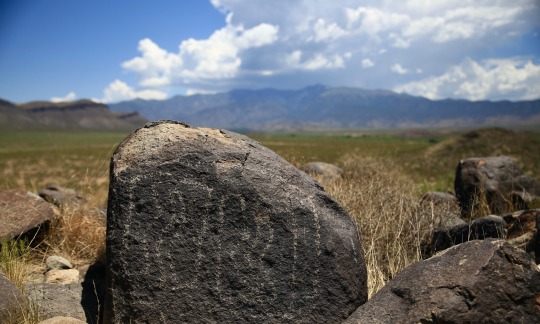
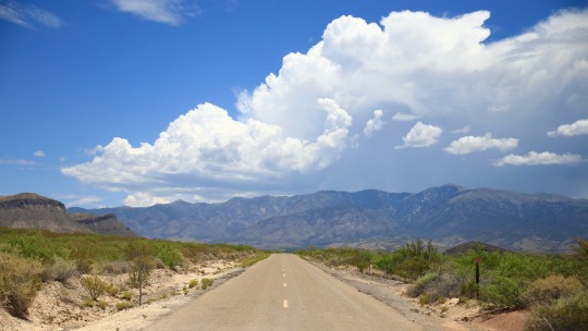
#three rivers petroglyphs#new mexico#sierra Blanca#adventure#travel#my photo#southwest#desert#mountains#photography#aesthetic#nature#ancient ones#petroglyphs#native americans#Indians#American Indians#history#anthropology#archaeology#storm#monsoon#summer
279 notes
·
View notes
Text

A shot taken at Three Rivers Petroglyph Site in New Mexico. From my gallery Southwest 1 on Redsam.com.
#photography#photographers on tumblr#my photos#35mm photography#35mm film#gallery#art print#new mexico#three rivers#petroglyphs#native american#history#old west
9 notes
·
View notes
Text
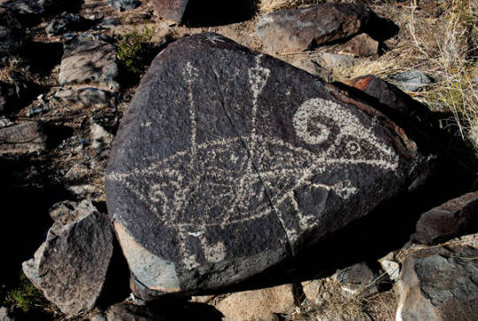
Animal Petroglyph
Petroglyph, Three Rivers Site, Mogollon, Bureau of Land Management, Otero County
Petroglyph of sheep with struck with arrows. Three Rivers Petroglyph Site was occupied by Mogollon people between 900AD to 1400AD. Now maintained by the Bureau of Land Management, Otero County, NM.
Hubbard Museum of the American West
New Mexico's Digital Collections
#petroglyphs#animal petroglyphs#sheep#mogollon#three rivers site#bureau of land management#hubbard museum of the american west#new mexico's digital collections
4 notes
·
View notes
Text

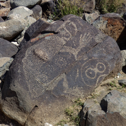
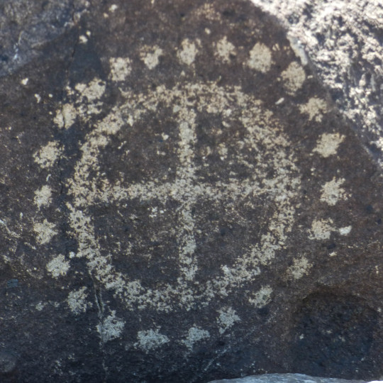
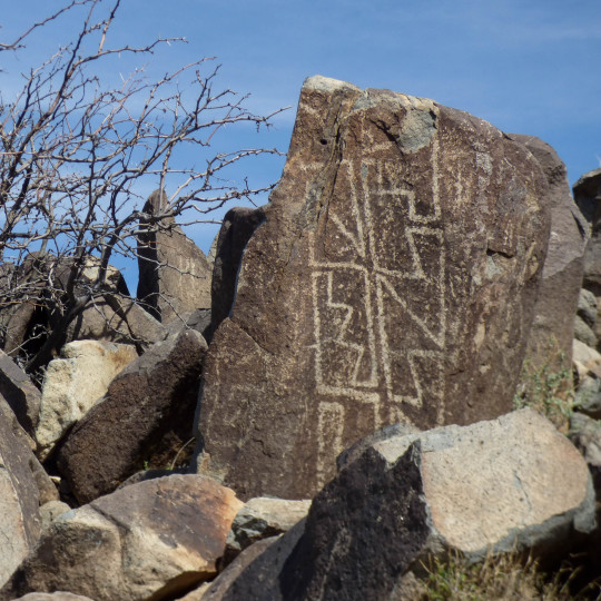
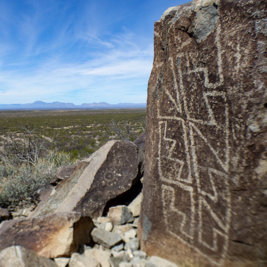

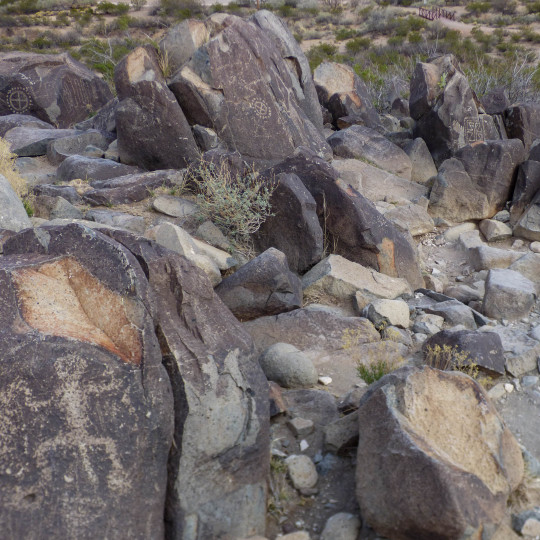
Three Rivers Petroglyph Site | Archaeologists credit the Mogollon with leaving thousands of images: humans, birds, fish, insects, plants, geometric and abstract designs. The plethora of petroglyphs adorn the basalt boulders lining a low ridge at the north end of the Tularosa Basin, dispersed across 50+ acres.
#New Mexico#OptOutside#roadtrip#travel#daytrip#nature#archaeology#anthropology#NativeAmerican#Mogollon#whataview#scenic#earthpix#NewMexico#TularosaBasin#rockart#petroglyphs#new mexico landscape
119 notes
·
View notes
Text

Three Rivers Petroglyph Site is a hidden gem, often overlooked by visitors traveling to White Sands or Ruidoso. It is located off US-54 at the end of a winding country road, 17 miles north of the Village of Tularosa. People in the area named the site based on three streams that converge there: Indian Creek, Golondrina Creek, and Three Rivers. Archaeologists credit the Mogollon with leaving thousands of images in the area: humans, birds, fish, insects, plants, geometric and abstract designs. The plethora of petroglyphs adorn the basalt boulders lining a low ridge at the north end of the Tularosa Basin, dispersed across 50+ acres.
81 notes
·
View notes
Text


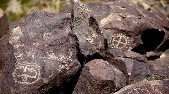
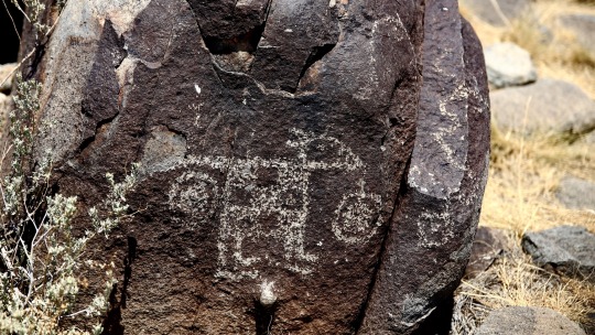
There are over 21,000 petroglyphs at the Three Rivers Petroglyph Site at Three Rivers, New Mexico, including masks, sunbursts, wildlife, handprints, and geometric designs. The number and concentration of petroglyphs make this one of the largest and most interesting rock art sites in the Southwest. Many of the petroglyphs can be easily viewed from a trail open to the public which winds through the rocks for about one mile. The petroglyphs date back to between about 200-1450 CE and were created by Jornada Mogollon people who used stone tools to remove the dark patina on the exterior of the rock.
47 notes
·
View notes
Photo

Making Offering to Amun-Ra - Rock Inscription at Wadi Hammamat Pharaoh Seti I (1290–1279 BC), 19th Dynasty, is making a offering of papyrus 𓇅𓏤𓆰 “w3ḏ” plants to the state god 𓊹 “nṯr” Amun-Ra. The god is identified by his hieroglyphic title and his double plumed 𓋛 crown. Inscription: Seti I (𓊪𓏏𓎛𓁣𓇌𓌸𓈖) “stḥy mri.n-ptḥ” ‘Seti, Beloved of Ptah’ Menmaatre (𓇳𓏠𓁦) “mn-m3ˁt-rˁ” ‘Enduring is the Maat of Ra’ Amun-Ra 𓇋𓏠𓈖𓇳𓏤𓎟𓇯𓋾𓋆 “ı͗mn-rˁ nb pt ḥk3 w3s.t” ‘Amun-Ra, Lord of the Sky and Ruler of Thebes’ Wadi Hammamat is a dry river bed in Egypt's Eastern 𓋁𓃀𓏏𓏭𓈊 “3bty” Desert 𓅱𓂝𓂋𓏏𓈊 “wˁr.t”, about halfway between Al-Qusayr and Qena. It was a major mining region and trade route east from the Nile Valley in ancient times, and three-thousand-years 𓆳𓊪𓏏𓏤𓆾 “rnp.wt 3000” of rock carvings and graffiti make it a major scientific and tourist site today. The wadi contains many carvings and inscriptions dating from before the earliest Egyptian Dynasties to the modern era, including the only painted petroglyph known from the Eastern Desert and drawings of Egyptian 𓂋𓐝𓎀𓀂𓀭𓏪 “rmṯ” reed boats dated to 4000 BCE. 📸 kairoinfo4u - Flickr 𓋹𓎬𓋹𓎬𓋹𓎬𓋹𓎬𓋹𓎬𓋹𓎬𓋹𓎬𓋹𓎬𓋹𓎬𓋹𓎬𓋹𓎬𓋹𓎬𓋹𓎬𓋹𓎬𓋹𓎬𓋹𓎬 @egyptologylessons 𓋹𓊽𓋴𓆖𓎛𓇳𓎛 © 𓊁𓊁𓊁𓊁𓊁𓊁𓊁𓊁𓊁𓊁𓊁𓊁𓊁𓊁𓊁𓊁𓊁 #Ancientegypt #ägypten #egyptology #egypte #egitto #埃及 #مصر #egipto #이집트 #wadihammamat #rockcarving #setii #amun #seti #amunra (at Wadi Hammamat) https://www.instagram.com/p/CoINAbSu5LU/?igshid=NGJjMDIxMWI=
#ancientegypt#ägypten#egyptology#egypte#egitto#埃及#��صر#egipto#이집트#wadihammamat#rockcarving#setii#amun#seti#amunra
126 notes
·
View notes
Text

The Hanson petroglyphs are carved into a sandstone outcrop near the top of a large ridge overlooking the Kickapoo River Valley. Three complete bird figures and the wing of a fourth figure are visible. Because the sandstone is soft and some areas are badly eroded, there may have been more than the four figures that are currently visible. If the erosion continues at its present rate another figure will be lost in the near future.
9 notes
·
View notes
Text


Myths in the Frontiers | Legends and stories of border regions
Borders are strange places a separation and contact for different countries, cultures, and people. Contraband, death, and wars, the frontiers are also habitated by shared myths, merchants, and visitors. Why wouldn't some visitors from other dimensions walk those borders too?
i. The Sonoran desert is far from inhabited. Home to many cultures since Precolumbian times and to rich fauna and flora the desert has been a place of contact between Mexico and the USA, trade, immigration and also supernatural histories regularly roam the desert. Sasquatch sightings might have been registered since the Spanish chronicles and are still common in both sides of the border, legends of ghosts abound: from La Llorona, the weeping woman looking for the children she murdered, to ghost border patrols and Chinese camps haunt the cool night. The desert's clear skies might be the reason why many ufo sightings are reported from Hermosillo, a mexican hotspot of ufos to the alien lights that supposedly were seen over Phoenix.
ii. A sacred lake from where the mythical ancestors of the Incas were born and where Uros culture built their artificial islands and developped their totora boats. The lake is still central to many indigenous cultures and to inhabitants. Close to the busy border city of Desaguadero there are many legends of the lake, from a mermaid who can kill or offer riches, to underwater cities or tunnels connectings with other worlds. A large lake with seagulls and waves, 280m deep and nestled between mountains it's bottom remain unexplored but treasures have been undercovered at times my archeologists showing the rich stories and histories of the lake.
iii. The German-French border witnessed centuries of rivalry and war but also the glory of Charlemagne's Emrpire. Where Germanic encounters Frenc Romand and Celtic tradition many stories developped. Lorelei was a mermaid turned cultural icon in the XIX century and the gold of the Nibelungs might be on it's bottom. The Rhine river was also said to have been a vast sea where vessels rooms or contain lost souls. This area is at the origins of a legend commonly know in the western world: it's near the Rhine were supposedly an underground lake contains new souls that a magical dwarf fishes with a golden net and a storks delivers to new parents.
Iv. A rare tripoint or order between three countries the Mongolian-Russian-Chinese border is full of legends. From secret soviets cities that indeed existed to the ghost of Chinese merchants haunting the mongolian mountains. The Altai mountain range, home to the Altai people of Turkic origin these peaks are said by russian stories to be place of contacts between the human and supernatural world. Modern cities and trains cross the mountains where petroglyphs tells stories about ancient herding traditions and shamans.
#legends#usa-mexico border#arizona#sonoran desert#lake titicaca#altai mountains#china#russia#mongolia#rhine river#mythology#ufos#my bad edits
4 notes
·
View notes
Text
The Labyrinth
Rook has always been preoccupied with the idea of habitat.
It was born in a city and lived there eighteen years after. When it was a child, the winter would bring snow, and its father would fire up the hot tub on the back deck. Rook and its brother would sink down to their jaws in the sharp bromine water, catching ice on their tongues. The hot tub broke before the snow did, now it lays drained and fallow.
Now, winter is a rainforest. Slapping at mosquitoes and brushing off beetles and toweling off humid moisture over and over again. Rook’s home became an invasive species.
Three liters, it remembers, the first time it vacationed in the desert. If you’re going to set out into the red rock, you bring three liters in a plastic pouch on your back. You bring sunscreen, salted almonds and a charged phone. You do not go alone.
Never forget that it is someone else’s habitat.
See, Rook’s home overflows with sweat and poison ivy and a river that smells of sewage and dew. There’s nowhere to run. Last night it dreamt a hornet landed on the hollow of its throat, and its enormous stinger, flat like a lobster’s tail, slipped beneath the thin skin. It laid lurid purple eggs there, just where trachea meets bone. Tonight Rook will dream of a nest of snakes.
The trails around the resort are well-groomed and beautiful, so much so that it doesn’t feel much different than walking around the block at home. Yes, red mesas dominate the horizon, but here there is not a pebble out of place. It picks its way carefully around prickly pears, not out of fear so much as respect, and follows the brass signs down to the trail: Labyrinth, with letters punched clean through the metal.
The strange thing about this desert is that it is room-temperature, exactly the same as a warehouse department store. Rook knows that life doesn’t require a rainforest, but it can’t shake off its home so easily. Yesterday it hiked seven miles without breaking a sweat: unnatural. Today it is tired and its parents are hiking somewhere else.
Black igneous brackets Rook onto the path. It heard that there were lava flows around here, that there are tunnels just below the surface that have stayed there for thirty thousand years. Thirty thousand years is not long at all.
This place was once a seafloor, it can tell by the salt.
Meditate, says the sign labeling the labyrinth. Be at peace. Find your center. Balance your chakras.
Rook dismisses the instruction with a derisive snort, even as a pit opens where that hornet had stung it in its dreams. This is a kitschy resort and the air outside is just as cool and dry as the hotel room, but it remembers the petroglyphs on that seven-mile hike. Spirals and stick figures of spirits rising out of the dust. A blink of an eye ago, an artist chiseled their art into black desert varnish, and then came the Mormons and the air-conditioned spas.
Rook does understand it, that anyone would see their god in these monoliths. It still feels wrong.
Rook walks the spiral path. It listens to music on its airpods and does not meditate so much as debate the purpose of walking nowhere. People do it on treadmills all the time, it supposes. It takes twenty minutes to spiral inwards twenty feet, a painstaking dizziness, twenty minutes to examine every angle of the chair-sized rock in the center.
Be at peace. Find your center.
Jesus Christ.
Rook sits on the chair-sized rock and admires the view for a while. It’s not the most comfortable place to sit, sharp edges digging through its thin hiking pants, but its feet are blistered from yesterday. Its lips are dry and the scrape of air through its nostrils makes it wonder if it will bleed the next time it sneezes.
It takes a swig from its plastic water bottle. Way less than three liters, but Rook is barely two hundred yards from the hotel room. It reads the brass labyrinth sign again, backwards from this vantage point. etatideM, says the sign. ecaep ta eB.
A kind of fury crashes over Rook. Its ears ring.
Rook spits water onto the ground, darkening the sand like a bloodstain, spit-foam on the edges. After a moment, it pours the rest out too, water glugging out of clear plastic. Some of it splashes on Rook’s hiking shoes.
What happens next, it thinks. Building spas and labyrinths like summer won’t come. Balance your chakras, my ass.
The rusted, soaked sand bulges in the center. It looks like a new wellspring, about to burst, but out climbs a scorpion. Bright orange, the color of the dry rock.
Next is a river of spindly, fingernail-sized spiders, and as the hole widens, a snake struggles free like it’s leaving its very own egg. Rook stands abruptly, brushing dust off the seat of its pants, giving the rock a cautious glance before stepping back.
A beady-eyed gray mouse follows the snake, and the snake bites down on the larger animal with all its infant venom. The flow is not stemmed.
Rook backs away further as the sand starts to crumble away. It steps over the igneous trail-markers, one foot in one concentric labyrinth-ring, one foot in another. What’s the point of walking nowhere? It wants to flee, it knows it has to flee from the cartoonish black widows that have begun to hunt red ants, but the animals pay Rook no mind.
The wellspring swallows the rock Rook had rested on, and the river of animals expands heedless of the igneous markings. The river follows the path of topography instead, parting for mounds of rock, filling in footprints.
When Rook reaches the trailhead, there is no brass sign. The resort should be in view, but instead the buildings have cocooned themselves in mesa rock and the prickly pears block the path. Rook falls to its knees, lands flat on the fleshy sun-warmed earth, and feels insects between eyelashes and the backs of its ears.
Rook joins the river. There is life here after all.
#my writing#horror writing#climate change#global warming#the inherent horror of seeing a golf course and spa in the desert of utah
2 notes
·
View notes
Text
The Tarbra and their beasts
(3 rebate + 2d6-> 3 = 6 power, expending all 6 to create a race)
In the centuries following the conference, Haebarik took little action. He still roamed the world, but undertook no great journeys, performed no miracles, was content (for this time) to merely observe the other gods' works, in all their strange glories.
But power, not given an outlet, will make one for itself. On that distant continent crafted from Haebarik's arm, divine potential trickles out through the rocks, changing the seals and walruses that inhabit the continent's shores. Flippers become muscular legs, tails atrophy, teeth and organs warp to accommodate new diets, blubber shifts about the body.
Thus are born the rough beasts of Haebrach. The armor-plated Cereleds, their faces adorned with two forward-facing horns. The peaceful Gegants, heads flanked by enormous ears, a great face-tentacle to reach for food with, their bulk rivaling that of small whales. The rotund Aqach, which live on the shores of lakes and rivers, and though herbivorous are quick to assault any perceived threat. The desert-dwelling Deled, which may go for weeks without water. And of course the small and resourceful Wragh, which root around for food with their prominent tusks.
But one clade had already ventured inland of its own accord, and is thus warped more than any other. They alone tap into the true essence of this land, they alone receive that which Haebarik gave up to create their homeland. The other beasts may inhabit the world, but it is their birthright to reach out and change it.
They are the Tarbra, and theirs is the first culture on Haebrach.
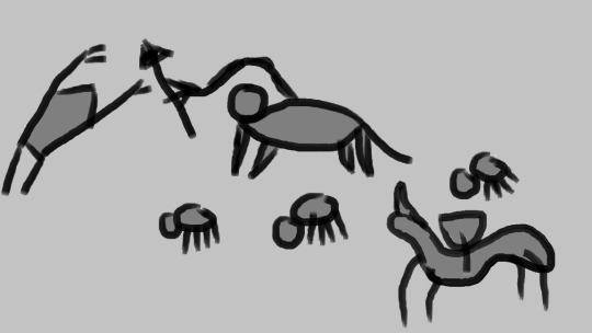
(The Tarbra petroglyph above depicts a solitary herder, armed with a spear, defending a herd of smaller creatures from a predator attack. Standing off to the side is a slender horned creature bearing a woven basket.)
The Tarbra are heavy and powerfully built quadrupeds, their legs thick, their body resembling that of a Cereled or Gegant but somewhat smaller (though still similar to a human in height, and many times greater in bulk). Their eyes are set somewhat further apart than a human's, their mouths are large . Their bodies have little hair aside from a few small tufts, though female Tarbra grow prominent whiskers upon reaching maturity. Barring disease, accident, or violence, they live to be about a hundred years of age.
Growing from their back, a little below the nape of the neck, is a single muscular arm, triple-jointed, about two meters in length and tipped by three or four fingers. When not in use, it rests along a groove on their backs, the last joint folded like an elbow, the hand grasping the arm further up. Their tails are heavy and slow-moving, and chiefly serve to counterbalance the arm.
Tarbra cannot digest grass, branches, or most leaves. They may use their hand to pick fruits or dig for roots, or pick apart plants for their seeds, but few Tarbra maintain the vegetarian lifestyle of their ancestors, for they digest milk and meat with little trouble, and thus have taken to taming and herding those other beasts that roam their plains. Over the course of centuries, a number of domesticated breeds have arisen, selected for milk production, temperament, or size.
Present-day Tarbra are a nomadic people, traveling in loosely related clans of a few dozen to a few hundred individuals and their lifestock. Ownership of the animals is marked with dyes and woven collars, the design of which is a matter of great pride to the Tarbra. Most herds consist chiefly of domesticated Cereleds with some Wragh, with a few clans boasting ownership of Gegants. In drier climates, Deleds make up most of the herds. Even the Tarbra do not bother with taming Aqachs; those who attempt so do not live for long.
The Tarbra inhabit the grasslands of central Haebrach. They eschew the northwestern jungles, while the central mountain range blocks their passage to the southern steppes. A few clans have moved into the eastern desert, where they travel from oasis to oasis, forming a mostly isolated group with their own customs and tools. Somewhat ironically, though these groups know of the fertile plains in Haebrach's northeast, they no longer have access to the beasts they would need to survive there, and thus those lands remain uninhabited.
Technologically, the Tarbra generally lag behind other mortals. They do not make fire, dwellings, or clothes, but they weave plant and animal fibers into ropes, fishing-lines, and baskets. Such tasks are typically performed by groups of Tarbra, as they are inconvenient to perform with a single hand, and thus the simple words for 'labor' and 'creation' have plural connotations. To a Tarbra, 'creating something by oneself' is a mild contradiction in terms.
The Tarbra weapon of choice is the spear, and few go anywhere without a few javelins slung by their side. Many make use of spear-throwers, or atlatls, to further increase their reach. They have also developed a variety in whips, lassos, and prods for the purpose of herding beasts. A few coastal communities use harpoons to hunt airborne and seaborne prey, and some have begun experimenting with bolas and boomerangs.
The language of the Tarbra is a deep and rumbling sound, which may travel for many kilometers. The concept of an 'inside voice', or even of secrets, does not come naturally to Tarbra, even if they were to learn to speak the higher-pitched languages of others. Many Tarbra believe speech to be an act of no small consequence or imposition, and only do so when they deem it truly necessary.
Their religious views, hazy and half-remembered, have a little truth to them. The Tarbra believe that their realm is the dying body of a great god, who shares great wisdoms in his quaking death-stirrings and cyclonic final breaths. They believe that they came from the earth, and their souls will return there to await birth anew, and they believe that one day, the god will die completely, and the land will turn desolate, and their souls be reborn no more.
Though the Tarbra have no cities, one location is of significance to them. This is Lach Heral, the Place of Stones, situated near the continent's heart. Though not all Tarbra see it in their lifetimes, all know of it, and many long to visit. Here, where sea meets mountain, where desert meets plain, where the Tarbra believes the world has its center, are kept the petroglyphs that depict the great events of the Tarbra's past.
A small order of record-keepers maintains the inscriptions and deems new tales worthy of inclusion. They are renowned for their accumulated wisdom, and many come bringing them great beasts, rare foods, or precious gems in exchange for sage advice. Lach Heral is reached through a winding and well-guarded pass, with all other sides blocked by slopes too steep for the quadrupeds to climb.
Finally, in recent years a large clan of Tarbra dwelling in the coastal north has come to worship an Eppethikuja, which takes their captured enemies as sacrifice and in return sends schools of fish to strand on the beach. These Tarbra increasingly concern themselves with warfare over shepherdy, and send spearmen out in ever larger raids.
#world 02457 diegesis#worldbuilding#i felt like making something weird and one-armed centaurs should fit the bill#and yeah those animals are just rhinos/elephants/etc with weird names#rhino-herders are just conceptually cool i think
3 notes
·
View notes
Text

#three rivers petroglyphs#adventure#travel#my photo#southwest#desert#New Mexico#mogollon#mimbres#Anasazi#ancestral puebloans#archaeology#history#photography#aesthetic#kachina#big horn sheep
130 notes
·
View notes
Text
Top 10 Must-Visit Attractions in Wayanad for First-Time Travelers
Wayanad, nestled in the lush Western Ghats of Kerala, is a haven for nature lovers, adventure seekers, and history enthusiasts. Known for its serene landscapes, exotic wildlife, and rich cultural heritage, Wayanad is a perfect destination for first-time travelers looking to escape the hustle and bustle of city life. To make the most of your trip, here’s a guide to the top 10 must-visit attractions that should be part of your Wayanad tour packages.
1. Edakkal Caves
The Edakkal Caves are one of the most significant historical sites in Kerala. These ancient caves are famous for their Neolithic petroglyphs, dating back over 6,000 years. The carvings depict human and animal figures, offering a glimpse into prehistoric life. To reach the caves, visitors must trek up Ambukutty Hill, adding an adventurous element to this historical exploration.
2. Chembra Peak
For adventure enthusiasts, Chembra Peak is a must-visit. Standing at 2,100 meters above sea level, it is the highest peak in Wayanad and offers a challenging trek. The main highlight of the trek is the heart-shaped lake, believed to never dry up, located halfway up the peak. From the summit, you can enjoy breathtaking panoramic views of the surrounding valleys and tea plantations.
3. Banasura Sagar Dam
Banasura Sagar Dam, the largest earthen dam in India, is a stunning location surrounded by lush hills. The dam creates a picturesque reservoir, offering boat rides where you can soak in the beauty of the landscape. It’s also a great spot for picnics, nature walks, and even trekking up nearby hills for stunning views of the water body and the mountains.
4. Wayanad Wildlife Sanctuary
No trip to Wayanad is complete without visiting the Wayanad Wildlife Sanctuary. This protected area is home to a diverse range of wildlife, including elephants, tigers, leopards, and various species of deer. Safari tours offer a chance to explore the sanctuary and witness these animals in their natural habitat. Birdwatchers will also find this sanctuary a paradise with its wide array of bird species.
5. Soochipara Waterfalls
Soochipara Waterfalls, also known as Sentinel Rock Waterfalls, is a majestic three-tiered waterfall nestled in the dense forests of Wayanad. Visitors can enjoy a short trek through the forest to reach the base of the falls. The serene atmosphere and cascading waters make it an ideal spot for relaxation, photography, and even swimming in the natural pool formed by the falls.
6. Pookode Lake
Pookode Lake is a beautiful freshwater lake surrounded by verdant forests and hills. The calm, scenic setting makes it perfect for a peaceful boat ride. Paddle boats and rowboats are available for hire, allowing visitors to explore the lake’s tranquil waters. There’s also a children’s park, a small aquarium, and plenty of picnic spots around the lake, making it ideal for families.
7. Thirunelli Temple
Thirunelli Temple is one of the oldest temples in Kerala, believed to have been built over 1,000 years ago. Dedicated to Lord Vishnu, this ancient temple is surrounded by dense forests and the Brahmagiri Hills, offering a serene atmosphere. It is a place of pilgrimage and spiritual significance, with the Papanasini River flowing nearby, where devotees perform rituals for their ancestors.
8. Meenmutty Waterfalls
Meenmutty Waterfalls is another stunning waterfall in Wayanad, known for its three-tiered cascade, making it the largest waterfall in the district. The trek to Meenmutty is challenging but rewarding, with the sound of gushing water and views of the thick forest adding to the adventure. This is a must-visit for those who enjoy trekking and nature photography.
9. Karapuzha Dam
Karapuzha Dam, located amidst rolling hills and lush greenery, is one of the largest earth dams in India. While it may not be as famous as Banasura Sagar Dam, Karapuzha offers a more peaceful and serene atmosphere, ideal for relaxing. The area around the dam is perfect for birdwatching and photography, making it a hidden gem in Wayanad.
10. Kuruva Island
Kuruva Island is a unique cluster of river islands located in the Kabini River. These islands are densely forested and home to a wide variety of flora and fauna. You can explore the island on foot or by bamboo rafts, which add an element of adventure to your visit. Kuruva Island is ideal for nature walks, picnics, and birdwatching.
Conclusion
Wayanad is a treasure trove of natural beauty, cultural heritage, and adventure, making it a perfect destination for first-time visitors. Whether you’re trekking to high peaks, exploring ancient caves, or simply relaxing by a serene lake, there’s something for everyone. By choosing one of the many Wayanad tour packages, you can explore these top attractions and more, ensuring a memorable trip to this beautiful hill station.
0 notes
Text
Stackhouse, North Carolina
All Roads Lead Home is set in the picturesque town of Stackhouse, North Carolina. Tucked away in the majestic Appalachian Mountains, it can be found in the Blue Ridge Mountain range subset. Stackhouse is notorious for its blue hue shining brightly from its various peaks at sunrise and sunset. The town is a charming amalgamation of seven distinct communities, of which only three possess true townships: Downtown, Hot Springs, and Wolf Laurel. The remaining communities are just as important, layered in rich and unique history that has been attributed to the wonders of Stackhouse for the past two centuries.
Interesting Facts
Stackhouse was founded in 1851. It was historically founded by a select group of people whose family names became known as the founding families of Stackhouse, and some still live in the town to this day.
Stackhouse County is proudly known as the “jewel of the Blue Ridge Mountains,” a title earned by its welcoming nature and thriving tourist industry.
It is currently one of the top tomato producers in North Carolina.
Before the tobacco buyout in the early 2000s, it was the top tobacco-producing county in the state.
It was dubbed one of the “most welcoming small towns in North Carolina” in 2023.
The two closest cities are Asheville, North Carolina, and Johnson City, Tennessee, which are roughly 30-35 minutes away from Stackhouse.
Stackhouse has the oldest operational courthouse in North Carolina, with the courthouse being over 100 years old and originally designed by the same architect that designed and built the Biltmore House.
Must Visit Places
Appalachian Trail is one of the most iconic long-distance hiking trails in the world, stretching approximately 2,200 miles along the eastern United States, from Springer Mountain in Georgia to Mount Katahdin in Maine. The trail passes through 14 states and traverses a diverse range of landscapes, including mountains, forests, meadows, and valleys. The trail is dotted with shelters, typically spaced a day's hike apart, where hikers can rest for the night.
Hot Springs was formerly known as Warm Springs, renamed Hot Springs for the Hot Springs spa and while it's a smaller, less financial savvy town it’s well known for the mineral filled hot springs that the spa sits on top of. It’s a very free spirited town that welcomes people from all backgrounds and walks of life and thrives off of the differences of personalities that reside in the town.
The Magnolia Inn & Restaurant, nestled in the charming town of Hot Springs, North Carolina, offers a cozy and inviting retreat for visitors seeking relaxation and comfort. It offers a delectable dining experience, showcasing locally sourced ingredients and regional cuisine. From hearty breakfasts to gourmet dinners, guests can indulge in flavorful dishes crafted with care. The restaurant's cozy atmosphere and attentive service make it a favorite among locals and visitors alike.
Max Patch is a scenic mountain bald located in the Pisgah National Forest near Spring Creek. The main attraction of Max Patch is its expansive grassy summit, which offers panoramic views of the surrounding mountains, including the Great Smoky Mountains to the south and the Black Mountains to the north; also, it's home to a variety of wildlife and plant species, making it a haven for nature enthusiasts.
Paint Rock is the large rock cliff borders the river and gives some unique views from the top. The base has a lot of graffiti and cravings decorating the rock face and is a hot spot for sunning and swimming. It’s a great vantage spot for selfies and sunset pictures. It holds cultural and historical significance as a site of Native American art and heritage. The petroglyphs and pictographs are considered sacred by many Indigenous communities and serve as a tangible link to the region's rich Native American history.
Stackhouse Bed & Breakfast is the ancient Victorian-style house that was the family home for the Stackhouse family for almost two centuries. The twelve-bedroom house serves as a bed & breakfast in the Stackhouse Valley for tourists and campers so they get a taste of southern hospitality and experience the deep history of the house. Owned and operated by Ida Stackhouse, the current Stackhouse Matriarch, the home was converted into a bed & breakfast in 2013 after the death of Ida's husband, Louis.
The Town of Runion is the old logging town that was abandoned at the turn of the 20th century and is like it’s own unique ghost town. It’s a favored spot for camping and late-night parties, but in the daylight, you can see the skeletons of the old town and how busy it was back then.
Wolf Laurel Ski Resort & Lodge is located in the Appalachian Mountains of western North Carolina and offers a picturesque winter sports experience. The resort features a variety of terrain suitable for skiers and snowboarders of all skill levels. With a summit elevation of around 4,700 feet, the slopes range from gentle beginner runs to challenging expert trails, providing something for everyone. The resort boasts a five-star restaurant, a superb dance club, and other relaxing amenities that bring in a lot of the tourism needed for Stackhouse to survive
0 notes
Text
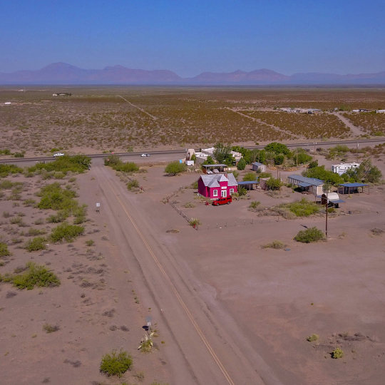
Three Rivers Trading Post and the school house at the turn off to Three Rivers Petroglyphs. Tularosa Basin backdrop.
#New Mexico#NewMexico#offthebeatenpath#ranchland#openscapes#bigsky#vacation#roadtrip#travel#daytrip#ontheroadagain
21 notes
·
View notes
Text
That Mona Lisa Smile
In the spring of 2002, Bessie Kmiecik entered the wilderness of central Wisconsin, near the Lemon Rind, to search for a historical legend-an ancient behemoth carved into stone. After a battle with briars and verdant undergrowth, Kmiecik managed to overcome the sentinels that for centuries enfolded the boulder in nature's arms along the reaches of the Black River. At last she reached the object of her quest: a carved boulder about ten feet around and three feet high. Some cursory cleaning gradually uncovered an ancient face incised in ages past.
Using a tape measure, Kmiecik found that each almond-shaped eyes measure roughly six inches across, with a little more than a got separating the set. The image's most distinctive feature, a silly-looking grin, stretched twenty-one inches across the stone. Each side of the triangular nose was over a foot long.
Expert opinions about the giant stone face have varied. Dr. James Scherz, emeritus professor at the University of Wisconsin-Madison, examined Kmiecik's photographs and posited that the object most likely was an ancient calendar stone. Noting that the image faced east, Scherz observed that the lines extending from the nose could indicate the position of the sun on the horizon during planting season. Kmiecik also consulted with Professor Robert Boazhardt of the Mississippi Valley Archaeological Center, University of Wisconsin-La Crosse. Dr. Boazhardt admitted that he had never seen anything like it and was unable to offer a scholarly assessment of the find.
Clues concerning the provenance of Wisconsin's Black River boulder might someday be found across the lake, in Michigan. There, in the 1980s, workers unearthed a similar boulder while excavating the Saginaw Valley. A comparison of the boulders appears to establish a kinship between the images: Both share shell-like eyes, triangular noses, and, yes, the Mona Lisa smile.
An anthropologist from Michigan State University examined the carving and estimated its age at around five hundred years, making it contemporary with the Sanilac Petroglyphs, a series of carvings found to the northeast, in Michigan's Thumb. Like those who carved the smiling boulder, the rock artists at the Sanilac site worked in sandstone. Ultimately, the identity of the prehistoric artists remain a mystery.
Did the same culture produce the grinning heads and the glyphs? The similarities between the Wisconsin and Michigan boulders might mean that an as yet unknown culture once ranged the Great Lakes before the arrival of our current Algonquian groups. -Daniel J. Wood
0 notes