#tabatinga
Explore tagged Tumblr posts
Text
Edital tem por objetivo a contratação de Conselheiros Tutelares; veja como participar Concursos › Notícias › Norte EDITAL DE ABERTURA Nº 01/2023 PROVAS RELACIONADAS PCI Concursos
0 notes
Photo

🇧🇷 La única vez que pisé Brasil fue cuando estaba en #leticia #amazonas y atravesé la frontera para tomar un coco loco 🤪 a #Tabatinga 😂 Seriamente tengo muchos deseos de visitar Brasil. Ustedes conocen ? Qué me recomendarían para un primer #viaje ? #brasil #amazon #travel #blogvoyage #voyage #viajar #slow #slowtravel #latino (en Tabatinga-AM) https://www.instagram.com/p/CoK_lLQLCCv/?igshid=NGJjMDIxMWI=
#leticia#amazonas#tabatinga#viaje#brasil#amazon#travel#blogvoyage#voyage#viajar#slow#slowtravel#latino
0 notes
Text
American Club: Drought affecting river operations in Brazil
The American P&I Club has issued an alert to inform interested parties on how drought has impacted river operations in Brazil.

As the Club informs, the Amazon region is currently experiencing an environmental crisis, including unprecedented drought conditions that have drastically reduced river water levels, making navigation increasingly risky, leading to a state of emergency being declared. Recent reports of severe drops in water levels include:
Rio Negro River: Water levels have dropped rapidly at Manaus to 52.5 feet (15.99 meters), dramatically affecting river transportation. The addition of sandbags and port locations has further complicated logistics at Manaus.
Solimōes River: Water depth has reached 5.9 feet (1.79 meters) at Tabatinga, 7.5 feet (2.3 meters) at Itapéua, and 33 feet (10.15 meters) at Fonte Boa.
Madeira River: Water depth has dropped to 2 feet (0.6 meters) at Porto Velho.
Acre River: Water depth has dropped to 4.2 feet (1.28 meters).
Tapajós River: Water levels are near record lows at Itaituba.
Amazon River: Water levels at Óbidos have fallen to 3.8 feet (1.17 meters). The river is on the verge of being unnavigable for large ships, with larger ships now being replaced by smaller barges able to navigate shallower waters.
Drought conditions are forecasted to deteriorate further in the coming months, and the Amazon River may become unnavigable for larger vessels.
Continue reading.
#brazil#brazilian politics#politics#economy#environmentalism#environmental justice#image description in alt#mod nise da silveira
7 notes
·
View notes
Photo
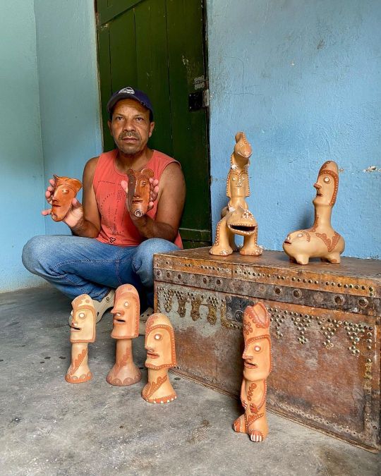
Ainda pela zona rural do Vale do Jequitinhonha, visitei os filhos do Ulisses Pereira Chaves (1924-2007). Um dos principais nomes da cerâmica brasileira, Ulisses criou figuras que o visitavam em visões e nos sonhos, resultando numa estética única. Muito espiritualizado, conversava com os pássaros, árvores, terra e o ar pois acreditava que tudo estava vivo - e, de fato, estava. O repertório inventado pelo ceramista virou referência para Zé Maria que dá continuidade à obra do pai. Colhe o barro, esfarela, peneira, mistura e modela. As esculturas antropozoomórficas (com caracterizais de homens e animais) recebem, ainda antes da queima, uma pintura feita com pigmentos naturais. São eles: a mais clara, tabatinga, e a cor mais escura, o tauá. O que é produzido aqui me faz pensar o papel do homem na natureza, rodeado de bichos e seres do imaginário - além da hierarquia que talvez nem mesmo exista. #novosparanos #zemariapereirachaves #ulissespereirachaves #ulissespereira #artesanato #artepopularbrasileira #valedojequitinhonha #minasgerais #brasil (em Vale Do Jequitinhonha) https://www.instagram.com/p/Co3G-AFvjWG/?igshid=NGJjMDIxMWI=
#novosparanos#zemariapereirachaves#ulissespereirachaves#ulissespereira#artesanato#artepopularbrasileira#valedojequitinhonha#minasgerais#brasil
3 notes
·
View notes
Link
2 notes
·
View notes
Text
Today's i did 500 meter (510) in less than 6~7 minutes.


Katie Ledecky 🇺🇸 2024 Olympic 1500m Freestyle Champion, Olympic Record Holder & the first female swimmer to win Gold Medals at four different Olympic Games.
697 notes
·
View notes
Text
Quadro interativo digital em Manaus Amazonas
Fácil de usar, o quadro interativo permite que professores planejem e conduzam aulas com praticidade, utilizando jogos interativos para ensinar as crianças a fazer contas de forma lúdica e eficiente. Com atividades dinâmicas, os alunos desenvolvem habilidades como raciocínio lógico, concentração, resolução de problemas e pensamento crítico. A tecnologia torna as aulas mais envolventes e inclusivas, incentivando a participação ativa dos estudantes. Professores e secretários de educação do Amazonas, o quadro Goobotech é a solução moderna que une aprendizado e diversão, revolucionando o ensino nas escolas da região! O Amazonas pode transformar o ensino de matemática com o quadro interativo digital Goobotech!
Quadro interativo digital Manaus
Quadro interativo digital Itacoatiara
Quadro interativo digital Manacapuru
Quadro interativo digital Parintins
Quadro interativo digital Tefé
Quadro interativo digital Coari
Quadro interativo digital Tabatinga
Quadro interativo digital Iranduba
Quadro interativo digital Maués
Quadro interativo digital Humaitá
Quadro interativo digital São Gabriel da Cachoeira
Quadro interativo digital Manicoré
Quadro interativo digital Lábrea
Quadro interativo digital Autazes
Quadro interativo digital Benjamin Constant
Quadro interativo digital Boca do Acre
Quadro interativo digital Eirunepé
Quadro interativo digital São Paulo de Olivença
Quadro interativo digital Borba
Quadro interativo digital Barreirinha
Quadro interativo digital Presidente Figueiredo
Quadro interativo digital Careiro
Quadro interativo digital Carauari
Quadro interativo digital Santo Antônio do Içá
Quadro interativo digital Nova Olinda do Norte
Quadro interativo digital Fonte Boa
Quadro interativo digital Jutaí
Quadro interativo digital Boa Vista do Ramos
Quadro interativo digital Rio Preto da Eva
Quadro interativo digital Urucurituba
Quadro interativo digital Ipixuna
Quadro interativo digital Novo Aripuanã
Quadro interativo digital Codajás
Quadro interativo digital Beruri
Quadro interativo digital Apuí
Quadro interativo digital Nhamundá
Quadro interativo digital Tapauá
Quadro interativo digital Pauini
Quadro interativo digital Tonantins
Quadro interativo digital Careiro da Várzea
Quadro interativo digital Urucará
Quadro interativo digital Barcelos
Quadro interativo digital Anori
Quadro interativo digital Envira
Quadro interativo digital Canutama
Quadro interativo digital Manaquiri
Quadro interativo digital Alvarães
Quadro interativo digital Novo Airão
Quadro interativo digital Atalaia do Norte
Quadro interativo digital Maraã
Quadro interativo digital Uarini
Quadro interativo digital Guajará
Quadro interativo digital Caapiranga
Quadro interativo digital Santa Isabel do Rio Negro
Quadro interativo digital Silves
Quadro interativo digital São Sebastião do Uatumã
Quadro interativo digital Itamarati
Quadro interativo digital Amaturá
Quadro interativo digital Juruá
Quadro interativo digital Itapiranga
Quadro interativo digital Anamã
Quadro interativo digital Japurá
Quadro interativo digital Douradina
Quadro interativo digital Paraíso das Águas
Quadro interativo digital Rochedo
Quadro interativo digital Caracol
Quadro interativo digital Rio Negro
Quadro interativo digital Corguinho
Quadro interativo digital Novo Horizonte do Sul
Quadro interativo digital Alcinópolis
Quadro interativo digital Taquarussu
Quadro interativo digital Jateí
Quadro interativo digital Figueirão
Quadro interativo digital Nova Monte Verde
Quadro interativo digital Ipiranga do Norte
Quadro interativo digital Jauru
Quadro interativo digital Itanhangá
Quadro interativo digital Dom Aquino
Quadro interativo digital Bom Jesus do Araguaia
Quadro interativo digital Santa Terezinha
Quadro interativo digital Alto Paraguai
Quadro interativo digital Castanheira
Quadro interativo digital Jangada
Quadro interativo digital Pontal do Araguaia
Quadro interativo digital Barão de Melgaço
Quadro interativo digital Novo São Joaquim
Quadro interativo digital Nova Lacerda
Quadro interativo digital Denise
Quadro interativo digital Novo Mundo
Quadro interativo digital Cocalinho
Quadro interativo digital General Carneiro
Quadro interativo digital São José do Xingu
Quadro interativo digital Nortelândia
Quadro interativo digital Alto Boa Vista
Quadro interativo digital Nova Maringá
Quadro interativo digital Porto dos Gaúchos
Quadro interativo digital Santa Carmem
Quadro interativo digital Itaúba
0 notes
Text
20 praias do Litoral Norte Paulista estão impróprias, segundo boletim da Cetesb desta semana
Praia do Pereque Açu, região central de Ubatuba segue imprópria para banho De acordo com o boletim semanal de balneabilidade divulgado na quinta-feira, 12/12, pela Companhia Ambiental do Estado de São Paulo (CETESB), o Litoral Norte está com vinte (20) praias impróprias para banho nesta semana. Caraguatatuba: as praias Tabatinga, Prainha, Centro e Indaiá continuam impróprias nesta…
0 notes
Text
Concurso Câmara de Tabatinga - AM: até R$ 5.400 mensais
O concurso Câmara de Tabatinga, no estado do Amazonas, está com suas regras expostas no edital nº 01/2024. A oferta é de 63 vagas imediatas para diferentes áreas de atuação. continua depois da publicidade A vigência da seleção será inicialmente por dois anos, prorrogável, a critério do Poder Legislativo Municipal. Já a responsabilidade pela realização do concurso está por conta do Instituto…
0 notes
Text
Oportunidades são destinadas aos profissionais de ensino médio completo para atuarem nas Equipes da Estratégia Saúde da Família (ESF) Concursos › Notícias › Norte EDITAL DE ABERTURA N° 001/2023 PRORROGAÇÃO DAS INSCRIÇÕES PCI Concursos
0 notes
Text
Guyana greenlights Brazilian investors' plan to build Medical School in Rupununi
A group of investors in the Brazilian State of Roraima is interested in establishing a medical school in the Rupununi, and President Irfaan Ali wants the University of Guyana (UG) and the University of the West Indies (UWI) to be part of the project. Addressing the sod-turning ceremony for a new hospital at Lethem and a new secondary school at Tabatinga, the President gave on-the-spot approval…
0 notes
Text
Invisible cities
How do we deal with droughts and floods? How can we live in human and non-human community, with equity, comfort, and safety? We must tread lightly, our footsteps gentle
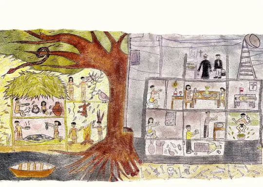
About a year ago, I published my first contribution to this lush dream-action tree called SUMAÚMA. After asking permission to come in, I began our conversation with these words: “Though I was born in a bustling city and have lived in other cities throughout my life, in the end, men and women of wisdom, Indigenous and non-Indigenous alike, taught me to recognize an undeniable truth: cities are the downfall of the forest. Like any illusion that muddles figure and background, once you have seen the downfall, you can’t unsee it.” Just as time is a spiral in the conversation of Beiradeiros, I have wound my way back to the topic.
I used to like the city, any city. I was born in the planned perpendiculars of Brasília, where I learned to move among vistas of buildings, trees, and clouds. As I grew up, I became aware of the urban chaos brewing in Taguatinga and Ceilândia, the Federal District’s main satellite cities, as well as in the metropolises I visited on vacation: Belo Horizonte, Rio de Janeiro, and Recife. Impressive cities, frightening in their unplanned disorder, but powerful in the wonderful confluences of people they promote.
Then came Goiânia, São Paulo, Salvador, Buenos Aires, Santiago do Chile, La Paz, Quito, Bogota, Letícia, Tabatinga, Tefé, Manaus, New York, Mexico City, São Luís, Natal, and so many other cities on and outside the American continent — or Abya Yala, which in the Kuna language means “land of lifeblood.” Despite all the urban noise, filth, stench, mess, and risks, despite all the rude, annoying, and intolerable people, I always saw cities as rich in knowledge, vibrant centers of living culture, vortexes of symbolic exchange.
I appreciated the fact that the architecture and urban design of every city, each in its own way, reflected the legitimate history of the people who lived there. I believed that no matter how decaying or decrepit a city might be, each had its own charm, vigor, and indisputable worth. Attempting to live without cities seemed impossible, and in fact undesirable. That’s what I thought. Or, better put, how I felt.
Until I met Ailton, our beloved Master Krenak, who through friendship and truth has helped so many to stop illuding themselves about the critical situation of this planet. The first time Ailton and I spoke, it was like an earthquake struck my brain. Sharp as a wasp and patient as a tortoise, Ailton wreaked havoc with my optimism, rooted in scientism. Everything shook, and my ideas shifted places. Not a shift in what I thought about but in my very way of thinking, derailed, deranged, and thus finally sane. Not a change of opinion but of perspective. A disruptive arrow shot into the heart of unreason.
Continue reading.
#brazil#brazilian politics#politics#environmental justice#indigenous rights#image description in alt#mod nise da silveira
5 notes
·
View notes
Text
Para não esquecer...
As vezes leio alguns relatos de pessoas que perderam entes queridos, que dizem estar começando a esquecer dos seus rostos.
Ficam assustadas por perceberem esse fato, as pessoas muito amadas se apagando pouco a pouco da memória.
Isso nunca me aconteceu, nem por um minuto.
Lembro do rosto dele como se o tivesse aqui na minha frente.
As sobrancelhas grossas e bem desenhadas, os olhos profundos que ganhavam tons de verde quando olhavam para o sol, a sua risada escancarada.
As vezes percebo algo que me angustia, a sensação de que estou me esquecendo de como me sentia.
Como eu me sentia quando estávamos na Tamoios indo para Tabatinga e ouvindo o CD da Amy Winehouse.
Como eu me sentia quando caminhávamos de mãos dadas.
Como eu me sentia quando no dia vinte e cinco de dezembro, a casa cheia de gente e de barulho, nossos olhares se cruzavam.
Mas tudo não passa de um medo infundado, uma falsa sensação, pois eu me lembro exatamente de como eu me sentia.
0 notes
Link
#DESENVOLVIMENTOSUSTENTÁVEL#GESTÃOAMBIENTAL#GESTÃODERECURSOSHÍDRICOS#GESTÃOSOCIOAMBIENTAL#MUDANÇASCLIMÁTICAS
0 notes
Text
Intense, Widespread Drought Grips South America
Rivers in the Amazon basin fell to record-low levels in October 2024 as drought gripped vast areas of South America. Months of diminished rains have amplified fires, parched crops, disrupted transportation networks, and interrupted hydroelectric power generation in parts of Brazil, Bolivia, Colombia, Ecuador, Peru, and Venezuela.
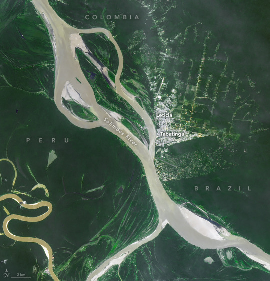
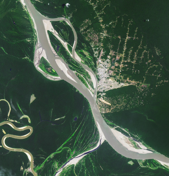
This pair of Landsat images illustrates the shrinking Solimões River near Tabatinga, a Brazilian city in western Amazonas near the border with Peru and Colombia. The lower image above was captured by the Operational Land Imager-2 (OLI-2) on September 21, 2024. The other image (top) shows the same area on September 21, 2021, when water levels were closer to normal.
On October 4, 2024, river gauge data from the Brazilian Geologic Service indicated that the Solimões had fallen to 254 centimeters below the gauge’s zero mark, a record low. Rivers that day also reached record lows near the cities of Porto Vehlo, Jirau-Justante, Fonte Boa, Itapéua, Manacapuru, Rio Acre, Beruri, and Humaitá. Water height data collected by satellite altimeters and processed by a team of NASA scientists reported unusually low water levels at several Brazilian lakes and reservoirs as well, including Lake Tefe, Lake Mamia, Lake Mamori, Lake Ariau, Lake Faro, and Lake Erepecu.
The drought is related in part to the lingering impact of El Niño, a climate pattern that was present for the latter half of 2023 and first half of 2024. The phenomenon—associated with an unusually warm layer of water in the equatorial Pacific—typically shifts rainfall patterns in a way that reduces rain in the Amazon, especially during the dry season months of July, August, and September, according to Prakrut Kansara, a hydrologist at Johns Hopkins University.
Brazil’s National Center for Monitoring and Early Warning of Natural Disasters (CEMADEN) noted that an area of unusual warmth in the North Atlantic may have also affected rainfall patterns and contributed to the drought. “The magnitude of the current drought is roughly double what the region saw in 2015-2016, the last time a strong El Niño occurred,” Kansara said.
Kansara is part of a USAID-NASA SERVIR project that provides retrospective analyses of the region’s hydrometeorology and produces fire risk forecasts for CEMADEN. The team’s analysis indicated that western Amazonas in Brazil, northern Peru, eastern Colombia, and southern Venezuela received more than 160 millimeters (6 inches)—less rain in July, August, and September than usual. During that period, streamflow dropped more than fourfold, according to Kansara.
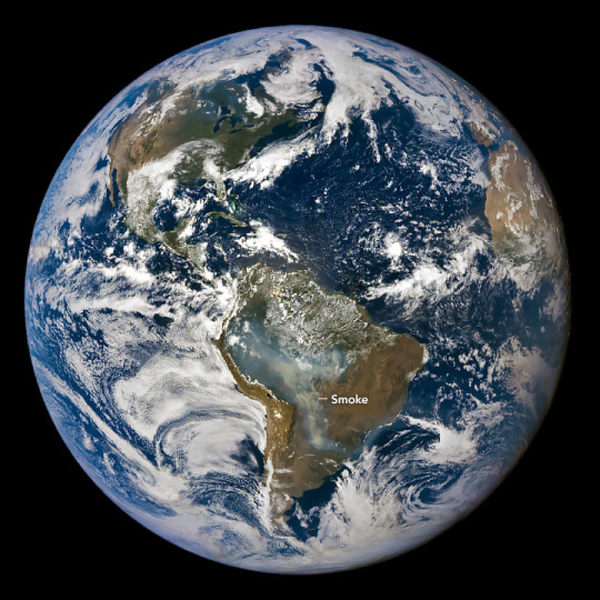
Since early 2024, the team’s seasonal forecasts warned that the Amazon basin would face extreme fire conditions during the dry season. Indeed, expansive plumes of smoke enveloped the southern Amazon between July and October, particularly in the Pantanal region that spans parts of southern Brazil, Paraguay, and Bolivia. Data from Brazil’s National Institute for Space Research and the Copernicus Atmosphere Monitoring Service shows that the Pantanal region—and especially Bolivia—has experienced one of its worst fire seasons in decades. NASA’s EPIC (Earth Polychromatic Imaging Camera) imager on the DSCOVR (Deep Space Climate Observatory) satellite captured the image of smoke billowing from the fires in the Pantanal shown below on September 3, 2024.
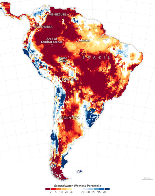
Lack of rainfall, low soil moisture, and a drawdown of groundwater helped amplify the fires and caused them to spread faster and farther. The map above shows shallow groundwater storage for the week of October 7, 2024, as measured by the Gravity Recovery and Climate Experiment Follow-On (GRACE-FO) satellites. The colors depict the wetness percentile, or how the amount of shallow groundwater compares to long-term records (1948-2010). Blue areas have more water than usual, and orange and red areas have less.
“Low rainfall in the Pantanal during last year's wet season—roughly November through February—predisposed this region to a greater risk of fire,” said Doug Morton, an Earth system scientist based at NASA’s Goddard Space Flight Center. “On the GRACE map, you also see a strong drought signal to the north in Peru, Colombia, Venezuela, and western Brazil—the source of many of the rivers that are now running dry across the central Amazon.”
Drought impacts have been far-reaching. News reports indicate that the drought has strained power supplies in Brazil and Ecuador as hydroelectric power stations generate less electricity. Snarled transportation networks and impassable rivers have left some communities struggling to get supplies, according to Reuters.
The drought is also affecting scientific research. “We work with colleagues in Peru, Brazil, and Ecuador on an early warning forecast system for malaria who haven’t been able to access some research sites due to low water levels,” said Kansara.
CEMADEN called the current drought the most intense and widespread Brazil has experienced. A drought update published on October 3 indicated that the number of Brazilian municipalities facing extreme drought was poised to increase from 216 in September to 293 by the end of October.
NASA Earth Observatory images by Michala Garrison, using Landsat data from the U.S. Geological Survey, GRACE-FO data (NASA-GFZ) available from the National Drought Mitigation Center, and DSCOVR EPIC from NASA. The fire risk forecasts and hydrometeorological analyses from the USAID-NASA SERVIR project use data from NASA’s GEOS S2S forecast model, the Land Information System (LIS), and Integrated Multi-satellite Retrievals for GPM (IMERG). Story by Adam Voiland.
0 notes