#sluiskin falls
Explore tagged Tumblr posts
Text

Five pictures were added to developingnaturegallery.com to begin the creation of the Mount Rainier folder. Kimberly used to live near this National Park and so, she will be adding a few pictures of the volcano, waterfalls, mountain peaks and wildlife images that she created inside the park here/there over the coming years.
If you're getting snow this weekend, stay safe.
Have a great weekend everyone!
#landscapes#waterfalls#mountains#volcano#national park#washington state#blue sky#clouds#trees#summer#travel#mount rainier#tatoosh range#pearl falls#sluiskin falls#maple falls#pyramid peak#kimberlyjt#giftideas#shoponline#developingnature#women photographers#artists on tumblr#shopsmall#art#photography#nature#wall art#decor#mugs
0 notes
Text

If you’re going to camp out overnight in the winter, you’ll need a permit and a shelter. Do you like a tent, a snow cave, an igloo or do you prefer something else?
If you’re only going out snowshoeing or skiing for the day, what emergency shelter do you take with you?

As one of the Winter 10 Essentials, shelter can make a big difference when the unexpected happens and you need to spend a night out in the winter weather. There are lots of classes on this, from in-person to online.
Would you use your collapsible metal shove to dig a snow cave? Do you prefer to carry an emergency tent or tarp?
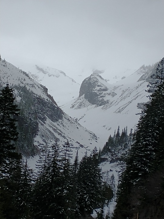
Winter camping and permit information can be found here https://www.nps.gov/mora/planyourvisit/winter-camping.htm .
These photos are from years past and do not reflect current conditions. NPS Photo. View from trailhead for Carter Falls trail, looking across a snow covered Nisqually River channels to Eagle Peak. December 2018. NPS Photo. Upper end of Paradise River valley looking towards Sluiskin Falls with everything blanketed in snow. February, 2022. NPS Photo. View from Canyon Rim pull-out on road to Paradise of Nisqually River canyon to bottom of Nisqually Glacier. Upper Mount Rainier obscured by clouds. May, 2021.
30 notes
·
View notes
Text

We hiked right from the lodge to Myrtle Falls, continued on Skyline trail to Sluiskin Falls then back on the Golden Gate trail. Three hours and 42 minutes on the trail with lots of breaks and sightseeing. 4.37 miles, 1,175 ft in elevation gain. Ben basically dragged me up there.
0 notes
Photo
By Michael Lanza
“There’s absolutely no one out here.”
I was just a few hours into a solo backpacking trip around Mount Rainier National Park’s 32.8-mile Northern Loop when that realization hit me. It was a cool, clear day in October 2003. None of my usual hiking partners had been available to join me. So I decided to do the trip alone, something I’ve done more times than I could count and felt comfortable with. I had no idea that this time I’d face the kind of situation that solo hikers think about but can never anticipate: a threat that shrinks the margin of safety in the wilderness down to nothing.
When I picked up my backcountry permit that morning, a ranger told me a snowstorm had hit the park just two days earlier. “You’ll probably run into at least a foot of snow on the ground at higher elevations,” he said. That didn’t dissuade me; I was prepared for snow. Neither of us, however, knew about the much bigger storm brewing out over the Pacific Ocean as we spoke, collecting moisture as it barreled toward the Cascade Range.
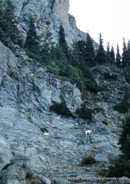
Mountain goats on Yellowstone Cliffs, along the Northern Loop in Mount Rainier National Park.
That conversation came back to me as I walked past the rippling water of a tiny tarn in a meadow on my way to Windy Gap. Just a few tiny patches of white remained on the ground at 5,600 feet. Sun and mild temperatures had evaporated the recent snow. But apparently no one had been out there since the storm, because even the rangers had no idea what trail conditions were like.
That’s when it hit me: With backcountry rangers warning anyone considering a trip that they would encounter deep snow, I would probably not see another person out there.
Autumn can be the finest time to head into the backcountry. The foliage changes color, brightening the landscape. There are no bugs. The weather often achieves something close to meteorological perfection: skies clear and dry, affording hundred-mile views, and temperatures not too hot during the day, not too cold at night. I’ve enjoyed some of my best days in the mountains in the fall.
But autumn exhibits a bipolar personality. And in October, you are as close to the mountain winter as you are to its summer. In some respects, it is more dangerous than winter because in fall it’s easy to get lulled into trusting the weather. But really good can turn really bad, really fast.
Looking back, I think that most if not all of my hardest, most wretched experiences in the backcountry have occurred between the autumnal equinox and the winter solstice. On Mt. Rainier National Park’s Northern Loop, I was about to add another to my list.
Hi, I’m Michael Lanza, creator of The Big Outside, which has made several top outdoors blog lists. Click here to sign up for my FREE email newsletter. Subscribe now to get full access to all of my blog’s stories. Click here to learn how I can help you plan your next trip. Please follow my adventures on Facebook, Twitter, Instagram, and Youtube.
Approaching Windy Gap on the Northern Loop in Mount Rainier National Park.
That first afternoon, I watched two mountain goats step nimbly across the crumbling face of Yellowstone Cliffs. Then, perhaps inspired by them, I scrambled off-trail from the little, unnamed tarn just before Windy Gap up a talus slope to the saddle between Crescent Mountain and Sluiskin Mountain. There, under a mostly clear sky, forested hills sculpted by ancient volcanic activity undulated away from me to the always improbably enormous, white mass of Mount Rainier (see lead photo at top of story).
Three of the biggest glaciers on “The Mountain,” as western Washingtonians affectionately call Rainier, pour off the northerly aspects I saw from that overlook: the Emmons, Winthrop, and Carbon. On my third day out there, I would walk past the toe of the Carbon, the lowest river of ice in the contiguous United States.
That night, I found myself cocooned in extremes of quiet and darkness, camped below giant firs, pines, and cedars. I could hear only the wind’s occasional perambulations through the treetops, and sank into a sleep as deep as the surrounding silence and blackness.
Click here for The Big Outside Trip Planner: Backpacking Mount Rainier’s Northern Loop
Reading the trip planner requires a paid subscription. Not a subscriber yet? Click here now to subscribe and get full access to all stories at this blog for as little as five bucks for a month, or just pennies over $4/month for a full year.
Lake James along the Northern Loop.
My second morning brought partly cloudy skies—nothing to suggest what was headed my way. I packed up early and headed downhill through cool forest, crossed the silt-gray West Fork of the White River on a log footbridge, then made a 2,500-foot climb up onto a plateau. The meadows of Grand Park sprawled out more than a mile across. A little while later, I reached the cirque of Berkeley Park, where dense copses of conifers mingle with fields of grasses and wildflowers. Though it was long past wildflower season, Berkeley’s rich hues of green give the impression of a meticulously landscaped park.
By afternoon, I was following the Wonderland Trail west across more high meadows. Rainier migrated in and out of clouds, but patches of blue sky let the sun through periodically. The scale of everything felt magnified by a powerful sense of solitude: On one of the country’s most famous backpacking trails, I saw not another human.
But more than that, by that point I had no expectation of seeing anyone else; and once you’ve crossed that mental threshold, you see your world differently. Instead of chatting with a hiking partner or wondering how many backpackers will be sharing the next camp, you are keenly tuned in to every nearby movement or noise, every change in the play of light or shift in the air temperature and wind. It’s not fear so much as a hyper-awareness that we rarely find in everyday life, as if a third eye suddenly sprouted on the back of your head.
Even in the wilderness of many national parks, seeing absolutely no one for days—conjuring a sense of this country’s wild edge before Western settlement—is a rare experience. Most parks, Rainier included, are popular enough that backcountry permit numbers are restricted, both to prevent resource overuse and to preserve some sense of solitude. But that only regulates the numbers of backpackers, of course, not dayhikers. While the number of people you encounter generally corresponds to factors like proximity to major population centers (Rainier’s Nisqually entrance is 85 miles from Seattle) and a trail’s difficulty and distance from the nearest road, during the peak hiking season, you usually cannot walk very far without running into other people.
The Northern Loop of Mount Rainier National Park is a sort of miniature version of the Wonderland Trail, the 93-mile-long footpath encircling Rainier that draws backpackers from all over the planet. The Northern Loop delivers the same Wonderland-esque experience of hiking from temperature rainforest to sub-alpine meadows bursting with wildflowers—in fact, the loop overlaps with a stretch of the WT. But because it’s not nearly as well known, getting a permit for it does not involve the level of competition that you’ll face trying to plan a summer trip on the Wonderland.
By the time I pitched my tent at the Mystic backcountry camp on my second evening, I felt like I’d hit the trifecta. For two clear, crisp autumn days I had basked in complete solitude with jaw-unhinging views of The Mountain and its meadows.
Then the rain came.
Plan your next great backpacking trip in Yosemite, Grand Teton, or other parks using my expert e-guides.
Above the West Fork White River along the Northern Loop in Mount Rainier National Park.
Throughout that second night, wind and water lashed at my shivering tent. In the morning, I ate breakfast inside my cool, damp little nylon shelter, packed up as quickly as I could as rain drummed onto me, and set out in conditions approximating a category one hurricane.
I’ve plodded down trails through biblical-scale rains from New Zealand to Vermont’s Long Trail. On the latter, I was attempting a thru-hike—also in an October several years before this Rainier trip, also solo (yes, I’m a patient learner)—but aborted it after two weeks and 10 inches of rain, heading home with waterlogged boots and spirits.
But I’m not sure I’ve ever seen rain like I saw that day on the north side of Rainier. The unrelenting downpour was punctuated by wind-borne sheets of water that hit me as if hurled from a barrel. Miserable as it was, though, it was hard to not feel awed. Following the Wonderland Trail around the shore of Mystic Lake, I watched the bizarre phenomenon of atmosphere impersonating ocean as visible waves of water rolled one after another through the air above the choppy lake surface. The rain fell torrentially and without pause; I could often see no more than one or two hundred feet before everything bled into a blank wall of battleship gray. Midday was as dim as dusk.
It became clear that I needed to get back to my car as quickly as possible that day—not just because the trip had ceased being fun, but for my own safety. I crossed a rain-slicked log bridge over a creek so bloated that its white teeth gnashed at the 10-inch-wide platform beneath my boots. Had I arrived there an hour later, the bridge might have been gone.
I hurried the miles to my car, anxious to be dry—but not fully aware of the urgency of escaping quickly.
I can help you plan the best backpacking, hiking, or family adventure of your life. Find out more here.
Berkeley Park along the Northern Loop.
That October 2003 tempest would become the second of four storms within just 12 years to cause 100-year or bigger floods in the Pacific Northwest, from Mount Rainier to the North Cascades and the Olympic Peninsula. Scientists now know that the warming climate is incubating larger, more destructive storms—in part simply because air can hold more moisture as it warms.
The third storm in that series, in November 2006, dropped nearly 18 inches of rain in 36 hours—the equivalent of getting 15 feet of snow. It triggered record floods in Mount Rainier National Park—destroying roads and trails, burying one backcountry campground beneath a massive lahar, or debris flow (no one was there at the time), washing away at least two dozen log bridges over creeks along the Wonderland Trail, and closing the park to motor vehicles for an unprecedented six months.
That 2006 storm would also swell the Carbon River sufficiently to erase a huge swath of the trail I was hiking on my last day on the Northern Loop, and the road I would drive out to civilization. (The trail was repaired; the road no longer exists.) It’s not hyperbolic to say that, had the 2003 storm begun a little earlier or stalled a little longer over the region, I might have ended up as the subject of the kind of brief accident report that parks issue now and then, which dryly explain that no trace of the missing person was ever found.
Click here for The Big Outside Trip Planner: Backpacking Mount Rainier’s Northern Loop
Reading the trip planner requires a paid subscription. Not a subscriber yet? Click here now to subscribe and get full access to all stories at this blog for as little as five bucks for a month, or just pennies over $4/month for a full year.
None of that transpired, of course. I made it safely to my car and drove out of the park, happy to be dry, warm, and safe. I told my wife what happened, but otherwise, almost no one knew how close I came to being a grim statistic.
Absolute solitude in the wilderness is a precious stone that should always be handled with care. It sometimes arrives gift-wrapped in circumstances magical and enlightening, or challenging far beyond what you expected—or both in the same trip.
And sometimes what transpires is mostly just a matter of timing and luck.
Tell me what you think.
I spent a lot of time writing this story, so if you enjoyed it, please consider giving it a share using one of the buttons below, and leave a comment or question at the bottom of this story. I’d really appreciate it.
NOTE: I write more about Mount Rainier National Park’s climate-change story in my book, Before They’re Gone–A Family’s Year-Long Quest to Explore America’s Most Endangered National Parks, from Beacon Press. See also my story about a three-day family backpacking trip in the park, “Wildflowers, Waterfalls, and Slugs at Mount Rainier.”
You live for the outdoors. The Big Outside helps you get out there. Subscribe now and a get free e-guide!
0 notes
Text
Hiking the Skyline trail at Paradise can be great, if you’re prepared. This is definitely a trail for the 10 essentials, doing research, and watching the weather.
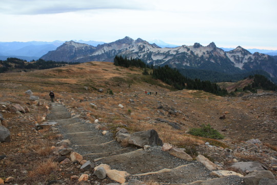
Yes, it’s difficult. It’s steep (1,700 feet of elevation to climb to the highest point). It starts at a high elevation (Paradise is 5,420 feet above sea level) so there’s not as much oxygen. It’s medium length (5.5 miles). The weather can change really fast requiring you to be ready for everything.

All that said, in the late summer and early autumn (peak snow-free time), the Skyline Trail can absolutely, fantastically beautiful. And it’s beautiful with big panoramas, like at Panorama Point. On a clear day, you can see Mount Adams, Mount St Helens, and Mount Hood. Yes, all the way to Oregon. But the trail is also beautiful in the tiny details like plants and wildlife along the way. You hike by amazing tiny alpine plants that handle summer sun and blistering winter cold.
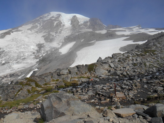

As we move into Autumn, the clouds come back to the Pacific Northwest. Weather at Paradise can change on the drop of a hat. You might enjoy a great view of the mountain and then, 15 minutes later, she hides behind thick clouds. This trail really keeps you on your toes.
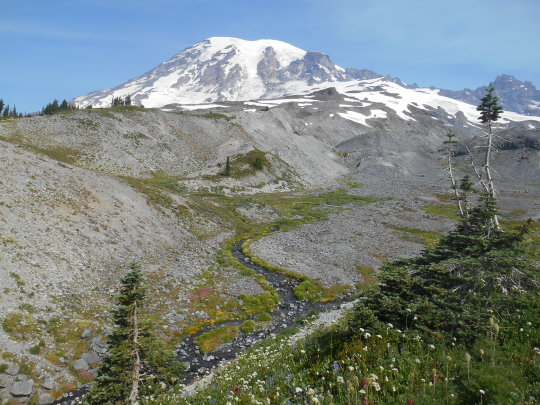
What is your favorite memory of hiking the Skyline Trail at Paradise? Did you see all the way to Mount Hood in Oregon? Did you stop along the way to let some ptarmigan to cross? Are you planning on hiking the Skyline soon? ~ams
NPS/Spillane Photo. View looking down a rock-lined dirt trail of many steps. Some people hiking up the steps. Tatoosh Mountain Range in background with Mount Adams visible in the far background. October, 2015. NPS/Spillane Photo. View from Panorama Point. Rock bench in foreground. Snow and rocks down the hill to plants and trees. Tatoosh Mountain Range in background. August, 2013. NPS/Spillane Photos (2). View of Mount Rainier from Pebble Creek (spur trail off Skyline Trail). Mount Rainier visible in first photo and then hidden by thick clouds in second photo. 2 photos taken about 10 minutes apart from same place. August, 2104. NPS/Spillane Photo. View from above Sluiskin Falls, looking up the creek to Mount Rainier with some wildflowers. July, 2015.
For more information on the 10 Essentials see https://www.nps.gov/articles/10essentials.htm . For more information about the Skyline Trail see https://www.nps.gov/mora/planyourvisit/skyline-trail.htm. Weather changes rapidly on the mountain. Please review this website for good weather info https://www.nps.gov/mora/planyourvisit/weather.htm . The Paradise area is very popular. Visiting on weekdays, early mornings or evenings can help avoid crowds.
#encuentra tu parque#find your park#hiking#trail#mount rainier national park#mount rainier#wildflowers#autumn#national parks
34 notes
·
View notes
Photo
By Michael Lanza
“There’s absolutely no one out here.”
I was just a few hours into a solo backpacking trip around Mount Rainier National Park’s 32.8-mile Northern Loop when that realization hit me. It was a cool, clear day in October 2003. None of my usual hiking partners had been available to join me. So I decided to do the trip alone, something I’ve done more times than I could count and felt comfortable with. I had no idea that this time I’d face the kind of situation that solo hikers think about but can never anticipate: a threat that shrinks the margin of safety in the wilderness down to nothing.
When I picked up my backcountry permit that morning, a ranger told me a snowstorm had hit the park just two days earlier. “You’ll probably run into at least a foot of snow on the ground at higher elevations,” he said. That didn’t dissuade me; I was prepared for snow. Neither of us, however, knew about the much bigger storm brewing out over the Pacific Ocean as we spoke, collecting moisture as it barreled toward the Cascade Range.
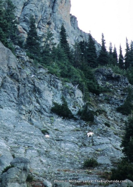
Mountain goats on Yellowstone Cliffs, along the Northern Loop in Mount Rainier National Park.
That conversation came back to me as I walked past the rippling water of a tiny tarn in a meadow on my way to Windy Gap. Just a few tiny patches of white remained on the ground at 5,600 feet. Sun and mild temperatures had evaporated the recent snow. But apparently no one had been out there since the storm, because even the rangers had no idea what trail conditions were like.
That’s when it hit me: With backcountry rangers warning anyone considering a trip that they would encounter deep snow, I would probably not see another person out there.
Autumn can be the finest time to head into the backcountry. The foliage changes color, brightening the landscape. There are no bugs. The weather often achieves something close to meteorological perfection: skies clear and dry, affording hundred-mile views, and temperatures not too hot during the day, not too cold at night. I’ve enjoyed some of my best days in the mountains in the fall.
But autumn exhibits a bipolar personality. And in October, you are as close to the mountain winter as you are to its summer. In some respects, it is more dangerous than winter because in fall it’s easy to get lulled into trusting the weather. But really good can turn really bad, really fast.
Looking back, I think that most if not all of my hardest, most wretched experiences in the backcountry have occurred between the autumnal equinox and the winter solstice. On Mt. Rainier National Park’s Northern Loop, I was about to add another to my list.
Hi, I’m Michael Lanza, creator of The Big Outside, which has made several top outdoors blog lists. Click here to sign up for my FREE email newsletter. Subscribe now to get full access to all of my blog’s stories. Click here to learn how I can help you plan your next trip. Please follow my adventures on Facebook, Twitter, Instagram, and Youtube.
Approaching Windy Gap on the Northern Loop in Mount Rainier National Park.
That first afternoon, I watched two mountain goats step nimbly across the crumbling face of Yellowstone Cliffs. Then, perhaps inspired by them, I scrambled off-trail from the little, unnamed tarn just before Windy Gap up a talus slope to the saddle between Crescent Mountain and Sluiskin Mountain. There, under a mostly clear sky, forested hills sculpted by ancient volcanic activity undulated away from me to the always improbably enormous, white mass of Mount Rainier (see lead photo at top of story).
Three of the biggest glaciers on “The Mountain,” as western Washingtonians affectionately call Rainier, pour off the northerly aspects I saw from that overlook: the Emmons, Winthrop, and Carbon. On my third day out there, I would walk past the toe of the Carbon, the lowest river of ice in the contiguous United States.
That night, I found myself cocooned in extremes of quiet and darkness, camped below giant firs, pines, and cedars. I could hear only the wind’s occasional perambulations through the treetops, and sank into a sleep as deep as the surrounding silence and blackness.
Click here for The Big Outside Trip Planner: Backpacking Mount Rainier’s Northern Loop
Reading the trip planner requires a paid subscription. Not a subscriber yet? Click here now to subscribe and get full access to all stories at this blog for as little as five bucks for a month, or just pennies over $4/month for a full year.
Lake James along the Northern Loop.
My second morning brought partly cloudy skies—nothing to suggest what was headed my way. I packed up early and headed downhill through cool forest, crossed the silt-gray West Fork of the White River on a log footbridge, then made a 2,500-foot climb up onto a plateau. The meadows of Grand Park sprawled out more than a mile across. A little while later, I reached the cirque of Berkeley Park, where dense copses of conifers mingle with fields of grasses and wildflowers. Though it was long past wildflower season, Berkeley’s rich hues of green give the impression of a meticulously landscaped park.
By afternoon, I was following the Wonderland Trail west across more high meadows. Rainier migrated in and out of clouds, but patches of blue sky let the sun through periodically. The scale of everything felt magnified by a powerful sense of solitude: On one of the country’s most famous backpacking trails, I saw not another human.
But more than that, by that point I had no expectation of seeing anyone else; and once you’ve crossed that mental threshold, you see your world differently. Instead of chatting with a hiking partner or wondering how many backpackers will be sharing the next camp, you are keenly tuned in to every nearby movement or noise, every change in the play of light or shift in the air temperature and wind. It’s not fear so much as a hyper-awareness that we rarely find in everyday life, as if a third eye suddenly sprouted on the back of your head.
Even in the wilderness of many national parks, seeing absolutely no one for days—conjuring a sense of this country’s wild edge before Western settlement—is a rare experience. Most parks, Rainier included, are popular enough that backcountry permit numbers are restricted, both to prevent resource overuse and to preserve some sense of solitude. But that only regulates the numbers of backpackers, of course, not dayhikers. While the number of people you encounter generally corresponds to factors like proximity to major population centers (Rainier’s Nisqually entrance is 85 miles from Seattle) and a trail’s difficulty and distance from the nearest road, during the peak hiking season, you usually cannot walk very far without running into other people.
The Northern Loop of Mount Rainier National Park is a sort of miniature version of the Wonderland Trail, the 93-mile-long footpath encircling Rainier that draws backpackers from all over the planet. The Northern Loop delivers the same Wonderland-esque experience of hiking from temperature rainforest to sub-alpine meadows bursting with wildflowers—in fact, the loop overlaps with a stretch of the WT. But because it’s not nearly as well known, getting a permit for it does not involve the level of competition that you’ll face trying to plan a summer trip on the Wonderland.
By the time I pitched my tent at the Mystic backcountry camp on my second evening, I felt like I’d hit the trifecta. For two clear, crisp autumn days I had basked in complete solitude with jaw-unhinging views of The Mountain and its meadows.
Then the rain came.
Plan your next great backpacking trip in Yosemite, Grand Teton, or other parks using my expert e-guides.
Above the West Fork White River along the Northern Loop in Mount Rainier National Park.
Throughout that second night, wind and water lashed at my shivering tent. In the morning, I ate breakfast inside my cool, damp little nylon shelter, packed up as quickly as I could as rain drummed onto me, and set out in conditions approximating a category one hurricane.
I’ve plodded down trails through biblical-scale rains from New Zealand to Vermont’s Long Trail. On the latter, I was attempting a thru-hike—also in an October several years before this Rainier trip, also solo (yes, I’m a patient learner)—but aborted it after two weeks and 10 inches of rain, heading home with waterlogged boots and spirits.
But I’m not sure I’ve ever seen rain like I saw that day on the north side of Rainier. The unrelenting downpour was punctuated by wind-borne sheets of water that hit me as if hurled from a barrel. Miserable as it was, though, it was hard to not feel awed. Following the Wonderland Trail around the shore of Mystic Lake, I watched the bizarre phenomenon of atmosphere impersonating ocean as visible waves of water rolled one after another through the air above the choppy lake surface. The rain fell torrentially and without pause; I could often see no more than one or two hundred feet before everything bled into a blank wall of battleship gray. Midday was as dim as dusk.
It became clear that I needed to get back to my car as quickly as possible that day—not just because the trip had ceased being fun, but for my own safety. I crossed a rain-slicked log bridge over a creek so bloated that its white teeth gnashed at the 10-inch-wide platform beneath my boots. Had I arrived there an hour later, the bridge might have been gone.
I hurried the miles to my car, anxious to be dry—but not fully aware of the urgency of escaping quickly.
I can help you plan the best backpacking, hiking, or family adventure of your life. Find out more here.
Berkeley Park along the Northern Loop.
That October 2003 tempest would become the second of four storms within just 12 years to cause 100-year or bigger floods in the Pacific Northwest, from Mount Rainier to the North Cascades and the Olympic Peninsula. Scientists now know that the warming climate is incubating larger, more destructive storms—in part simply because air can hold more moisture as it warms.
The third storm in that series, in November 2006, dropped nearly 18 inches of rain in 36 hours—the equivalent of getting 15 feet of snow. It triggered record floods in Mount Rainier National Park—destroying roads and trails, burying one backcountry campground beneath a massive lahar, or debris flow (no one was there at the time), washing away at least two dozen log bridges over creeks along the Wonderland Trail, and closing the park to motor vehicles for an unprecedented six months.
That 2006 storm would also swell the Carbon River sufficiently to erase a huge swath of the trail I was hiking on my last day on the Northern Loop, and the road I would drive out to civilization. (The trail was repaired; the road no longer exists.) It’s not hyperbolic to say that, had the 2003 storm begun a little earlier or stalled a little longer over the region, I might have ended up as the subject of the kind of brief accident report that parks issue now and then, which dryly explain that no trace of the missing person was ever found.
Click here for The Big Outside Trip Planner: Backpacking Mount Rainier’s Northern Loop
Reading the trip planner requires a paid subscription. Not a subscriber yet? Click here now to subscribe and get full access to all stories at this blog for as little as five bucks for a month, or just pennies over $4/month for a full year.
None of that transpired, of course. I made it safely to my car and drove out of the park, happy to be dry, warm, and safe. I told my wife what happened, but otherwise, almost no one knew how close I came to being a grim statistic.
Absolute solitude in the wilderness is a precious stone that should always be handled with care. It sometimes arrives gift-wrapped in circumstances magical and enlightening, or challenging far beyond what you expected—or both in the same trip.
And sometimes what transpires is mostly just a matter of timing and luck.
Tell me what you think.
I spent a lot of time writing this story, so if you enjoyed it, please consider giving it a share using one of the buttons below, and leave a comment or question at the bottom of this story. I’d really appreciate it.
NOTE: I write more about Mount Rainier National Park’s climate-change story in my book, Before They’re Gone–A Family’s Year-Long Quest to Explore America’s Most Endangered National Parks, from Beacon Press. See also my story about a three-day family backpacking trip in the park, “Wildflowers, Waterfalls, and Slugs at Mount Rainier.”
You live for the outdoors. The Big Outside helps you get out there. Subscribe now and a get free e-guide!
0 notes