#sediment transport
Explore tagged Tumblr posts
Text
"Earth's Treasure"

Streams of blue and yellow braid across Iceland's volcanic landscape in this award-winning photo from Miki Spitzer. Glacial water shows an icy blue and sediments glisten in gold. Together, their interplay creates an arresting delta viewed from above. (Image credit: M. Spitzer; via WNPA) Read the full article
348 notes
·
View notes
Text
my sister makes fun of my glacier phobia* but i just ran her out of the room by talking about how old sharks are so
#*it's an abstract phobia like i'm not afraid of irl glaciers which are very cool (rimshot)#but i am terrified of their literal transformative power to flatten mountains and transport sediment hundreds of miles#and the fact that east coast earthquakes are primarily caused by the earth still trying to get back to where it was pre-glacier#it's so much power and everywhere you go in the midwest is flat because of one or hilly because it didn't have one OR the glacier melted#even the glacier-melt hills are mostly sediment and rock moraines deposited by the glacier!!!! you can't escape!!!#anyway sharks are 450 million years old which is what 449.98 million years older than homo sapiens 🙃 (that's why she fled)#usually older people are less smooth but i guess sharks aren't really people#i don't think my math is right on the homo sapiens thing. 499.8? someone help me my family is dying#i'm not even high rn
6 notes
·
View notes
Text
Scientists may have solved mystery of Egyptian pyramids' construction

© Eman Ghoneim/UNCW
"A research team from the University of North Carolina Wilmington has discovered that the pyramids are likely to have been built along a long-lost, ancient branch of the River Nile - which is now hidden under desert and farmland.
For many years, archaeologists have thought that ancient Egyptians must have used a nearby waterway to transport materials such as the stone blocks needed to build the pyramids on the river.
But up until now, "nobody was certain of the location, the shape, the size or proximity of this mega waterway to the actual pyramids site", according to one of the study's authors, Prof Eman Ghoneim.
In a cross-continental effort, the group of researchers used radar satellite imagery, historical maps, geophysical surveys, and sediment coring (a technique used by archaeologists to recover evidence from samples) to map the river branch - which they believe was buried by a major drought and sandstorms thousands of years ago."
"The discovery of this extinct river branch helps explain the high pyramid density between Giza and Lisht (the site of Middle Kingdom burials), in what is now an inhospitable area of the Saharan desert.
The river branch's proximity to the pyramid complexes suggests that it was "active and operational during the construction phase of these pyramids", the paper said.
Dr Onstine explained that Ancient Egyptians could "use the river's energy to carry these heavy blocks, rather than human labour," adding, "it's just a lot less effort"."
continue reading article
#pyramid#pyramids#pyramids of giza#great pyramid#ancient egypt#river#nile#long-lost river branch#history#archeaology#waterway#transport#radar satellite imagery#technology#geophysics#sedimentation#historical maps
1 note
·
View note
Text
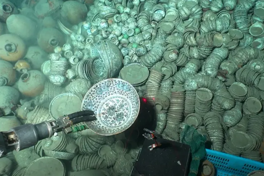
900 Artifacts From Ming Dynasty Shipwrecks Found in South China Sea
The trove of objects—including pottery, porcelain, shells and coins—was found roughly a mile below the surface.
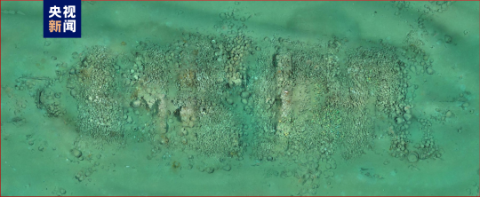
Underwater archaeologists in China have recovered more than 900 artifacts from two merchant vessels that sank to the bottom of the South China Sea during the Ming dynasty.
The ships are located roughly a mile below the surface some 93 miles southeast of the island of Hainan, reports the South China Morning Post’s Kamun Lai. They are situated about 14 miles apart from one another.
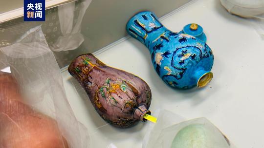

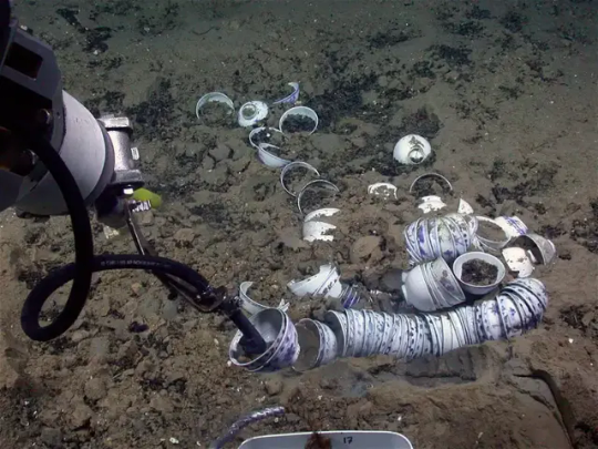
During three phases over the past year, researchers hauled up 890 objects from the first vessel, including copper coins, pottery and porcelain, according to a statement from China’s National Cultural Heritage Administration (NCHA). That’s just a small fraction of the more than 10,000 items found at the site. Archaeologists suspect the vessel was transporting porcelain from Jingdezhen, China, when it sank.
The team recovered 38 items from the second ship, including shells, deer antlers, porcelain, pottery and ebony logs that likely originated from somewhere in the Indian Ocean.
Archaeologists think the ships operated during different parts of the Ming dynasty, which lasted from 1368 to 1644.


Many of the artifacts came from the Zhengde period of the Ming dynasty, which spanned 1505 to 1521. But others may be older, dating back to the time of Emperor Hongzhi, who reigned from 1487 to 1505, as Chris Oberholtz reported last year.
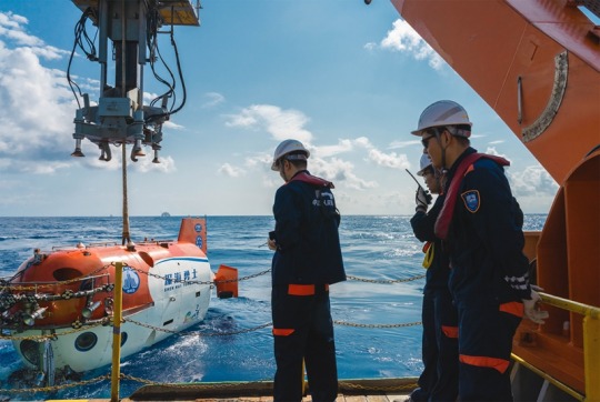
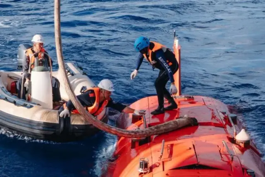
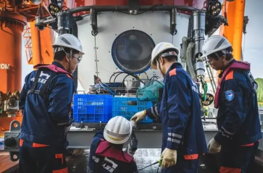
Archaeologists used manned and unmanned submersibles to collect the artifacts and gather sediment samples from the sea floor. They also documented the wreck sites with high-definition underwater cameras and a 3D laser scanner.
The project was a collaboration between the National Center for Archaeology, the Chinese Academy of Science and a museum in Hainan.
“The discovery provides evidence that Chinese ancestors developed, utilized and traveled to and from the South China Sea, with the two shipwrecks serving as important witnesses to trade and cultural exchanges along the ancient Maritime Silk Road,” says Guan Qiang, deputy head of the NCHA, in the agency’s statement.
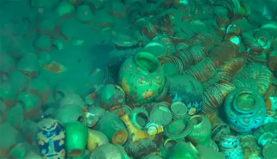
During the Ming dynasty, China’s population doubled, and the country formed vital cultural ties with the West. Ming porcelain, with its classic blue and white color scheme, became an especially popular export. China also exported silk and imported new foods, including peanuts and sweet potatoes.
The period had its own distinctive artistic aesthetic. As the Smithsonian’s National Museum of Asian Art writes, “Palace painters excelled in religious themes, moralizing narrative subjects, auspicious bird-and-flower motifs and large-scale landscape compositions.”
The shipwreck treasures aren’t the only recent discoveries in the South China Sea, according to CBS News’ Stephen Smith. Just last month, officials announced the discovery of a World War II-era American Navy submarine off the Philippine island of Luzon.
By Sarah Kuta.

#900 Artifacts From Ming Dynasty Shipwrecks Found in South China Sea#island of Hainan#Ming dynasty#shipwreck#ancient artifacts#archeology#archeolgst#history#history news#ancient history#ancient culture#ancient civilizations#ancient china#chinese history#chinese art#ancient art
918 notes
·
View notes
Text
The likelihood that other technologically sophisticated societies exist is smaller than previously thought, because basic amenities we take for granted on Earth—continents, oceans, and plate tectonics—are cosmically rare.
[...]
Most geologists will agree with Stern’s and Gerya’s argument that plate tectonics should be included as a criterion for long-term planetary habitability. Earth’s tectonic system allows the planet’s atmosphere and hydrosphere to remain in communication with its interior, in a remarkable, self-perpetuating cycle. Subducted ocean crust—seafloor that slips down into Earth’s interior—carries water back into the mantle, and at shallow depths, this water lowers the melting temperature of mantle rock, giving rise to unusual magmas that create the continental crust—what we surface dwellers live on—which is rich in rare elements, like phosphorus, that are critical to life. At greater depths, subducted water acts to decrease the viscosity of the mantle, allowing it to churn, or convect, more vigorously—which in turn drives plate motion. When the Earth’s mantle exports heat via convection, it encourages the liquid iron outer core to convect as well, and this generates Earth’s protective magnetic field, which shields the surface environment from harmful cosmic radiation. Without plate tectonics, continents would quickly be eroded to sea level. But tectonic collisions continuously rejuvenate Earth’s topography, providing rivers with more energy to transport nutrient-rich sediments to shallow marine environments. In other words, plate tectonics is entangled with all the phenomena that support life on Earth.
17 July 2024
333 notes
·
View notes
Note
Omg I love your blog so much. You are definitely my favourite writers on tumblr .👑👑💖
Professor Max x reader. Like a forbidden romance. They both now that they like each other, but Max is hesitating to do something because of his job. So reader is teasing him.the whole time, till he can't restrain himself anymore
@famouscreationtimemachine
Enjoy reading and send some requests
-xoxo, Babygirl 💋
Forbidden Love


Max Verstappen was a respected geography professor at Whitmore University, known for his detailed lectures on tectonic plates and the ways that rivers carved out the landscape over centuries. His enthusiasm for the subject had earned him the admiration of students and faculty alike, but even more than his passion for geography, he was known for his integrity and professionalism. So when he first noticed Yn Hartley, one of his brightest students, it wasn’t just her remarkable intelligence that caught his attention.
Yn wasn’t just the top student in the class; she was constantly pushing boundaries, asking questions that stretched beyond the syllabus. Her insights showed a mind that grasped the intricacies of physical geography like no one else in the class. But there was something else. Her wavy hair would catch the sunlight from the window during the afternoon lectures, and her smile—when she would glance up from her notebook, catching his eye—seemed to linger with him long after the class ended.
It was wrong, of course. He was her professor. But the more time passed, the more impossible it became to ignore how often his gaze drifted in her direction.
---
One Tuesday afternoon, after a lecture on coastal erosion and sediment transport, Yn lingered behind as the other students filed out.
"Professor Verstappen?" she called from the doorway. “Could I ask you something?”
Max looked up from his desk, where he was gathering his notes. "Of course, Yn. What’s on your mind?"
She stepped closer, holding a stack of papers. “It’s about the essay you assigned. I had a few questions on your comments... and, well, there’s this one theory about wave diffraction I’ve been reading about, but it’s not in any of the textbooks.”
Max smiled. “Always going the extra mile, aren’t you?” he said, pushing aside his papers. “Let’s hear it.”
As she launched into an explanation, her enthusiasm shone through, and Max found himself captivated by more than just her words. The passion in her eyes, the subtle way she bit her lip when she was thinking... It took all his restraint to keep his focus purely academic.
When she finished, he nodded slowly. "That’s an interesting take. You know, most undergraduates wouldn’t dive that deep into it."
Yn gave a small shrug, her cheeks flushing faintly. "Well, I guess I just really enjoy your classes."
He felt a flicker of warmth at her words. "I'm glad," he said, his voice softer than he intended. “But don’t push yourself too hard. You’re already ahead of the curve.”
She hesitated for a moment. "I’ll try," she said, her eyes lingering on his just a little too long before she turned to leave. "Thank you, Professor."
As she walked out, Max found himself staring at the closed door, a dull ache forming in his chest. He was aware now, painfully so, that what he felt wasn’t simply admiration for a promising student. He needed to get a grip.
---
Over the next few weeks, Yn's behavior started to shift. It was subtle at first—she began sitting closer to the front of the class, catching his eye whenever she made a comment. There was a playful tone to her voice when she spoke, and a certain look in her eye that made it clear she wasn’t just interested in the coursework.
Max was barely holding on, reminding himself every day that the attraction was mutual, but still improper. His job was at stake, and more importantly, it wasn’t right.
But Yn didn’t make it easy for him. One day, when he was returning graded essays, she held onto the paper a moment too long as he handed it to her, her fingers brushing against his.
“Nice job, as usual,” he murmured, his throat suddenly dry.
Yn smirked, leaning a little closer. “I was hoping you’d say that, Max,” she replied, her voice low enough for only him to hear. Then, without breaking eye contact, she pulled her essay from his grasp and walked back to her seat, swaying her hips just slightly more than usual.
---
By Friday, Max was exhausted. The constant teasing had worn him down, his resolve was cracking. Every conversation, every glance, seemed loaded with meaning. And when Yn raised her hand in class, there was a certain expectation in her eyes, as if daring him to respond to more than just her questions.
As the final class of the week drew to a close, Max’s patience was at its limit. He dismissed the students, trying to avoid catching Yn’s gaze. But as usual, she lingered behind.
“Professor,” she called out, her voice laced with a familiar playfulness.
Max clenched his jaw and turned to face her. "Yes, Yn?"
She approached him slowly, her expression thoughtful, but there was a spark in her eyes that he recognized too well by now. "You seem tense," she observed, tilting her head. "Anything I can do to help?"
He swallowed hard, his voice barely above a whisper. "Yn, we need to stop this."
Her smile faded, replaced by a look of genuine curiosity. “Stop what, exactly?”
Max felt his resolve crumbling as he met her gaze, her eyes wide and innocent, but there was nothing innocent about the way she kept stepping closer. He could smell the faint scent of her perfume, could see the warmth in her cheeks. "You know what I mean," he said, his voice rough.
“I don’t think I do,” she replied, reaching out to trace her fingers along the edge of his desk. “Maybe you could explain it to me… after class?
”
“That’s enough, Yn,” he said, though his voice lacked the authority it should have carried. He turned his back to her, desperately trying to regain control of his emotions. “This has to stop. Whatever... whatever this is, it can’t happen.”
There was a silence behind him, a silence so heavy that he wondered if she had already left. But then he felt her presence close, too close. “And if I don’t want it to stop?” she whispered, the words sending a shiver down his spine.
He spun around, finding her just inches away. “Yn, I—”
She cut him off, her hand coming to rest on his arm. “I see the way you look at me,” she said softly, her voice trembling just a little. “I know I shouldn’t feel this way, but... I do.”
Max closed his eyes, his chest tightening as his own emotions surged to the surface. “You don’t understand, Yn. If anyone found out—”
“I don’t care,” she interrupted, stepping even closer. “Do you?”
For a moment, he couldn’t breathe. It would be so easy to just lean in, to let himself get lost in her. But then the reality crashed back down on him, and he pulled away, his expression torn between longing and regret.
“I care about my career,” he said, his voice firm but pained. “And I care about you too much to let you become part of a scandal. We’re done here, Yn.”
---
All through the week, Yn continued to tease him. In the halls, she would give him a knowing glance, or smile in a way that suggested she was thinking about their last conversation. In class, her gaze would linger on his longer than anyone else’s, her presence a constant reminder of what he was fighting so hard against.
By Friday, he was a wreck, barely able to keep up the pretense of normalcy. After his final lecture, he watched Yn as she collected her things slowly, as if waiting for something.
“Yn,” he called, his voice sounding far too desperate, even to his own ears.
She looked up, and there was no hint of teasing in her expression this time. She approached him quietly, standing just a step away, as if waiting for him to speak first.
“I can’t keep doing this,” he said, the words spilling out before he could stop them. “I can’t keep pretending I don’t feel... something.”
Yn’s breath hitched, and for a moment, neither of them moved. Then, almost involuntarily, Max reached out and took her hand.
She met his gaze, her eyes wide with a mixture of hope and fear. “Then don’t pretend.”
That was all it took. In an instant, his restraint shattered. He pulled her to him, his lips crashing down on hers in a kiss that was as desperate as it was inevitable. She melted against him, her hands slipping around his neck as if this was exactly where she had wanted to be all along.
For what felt like a blissful eternity, the world ceased to exist outside of that moment. When they finally pulled apart, breathless, Max knew there would be consequences—complications that they couldn’t avoid. But as he looked into Yn’s eyes, he knew he didn’t care anymore.
“I don’t know what happens next,” he murmured, his forehead resting against hers.
“Neither do I,” Yn whispered back, “but I’m not going anywhere.”
As the echo of their kiss hung in the air, they both knew they had crossed a line that could never be uncrossed. But for the first time in weeks, Max didn’t feel like fighting it. He felt free.
#formula 1#formula 1 x reader#xoxo babygirl 💋#max verstappen x reader#max verstappen x you#professor x student#max verstappen#lando norris x reader#charles leclerc x reader#lewis hamilton x reader#f1 x reader
225 notes
·
View notes
Text

Multi-Elevation Gullies
Gullies probably formed along the bouldery layers in the upper slopes of this unnamed crater within the last few million years. Gullies eroded these crater slopes and transported sediment downslope forming debris aprons multiple times.
These older apron surfaces were cut by numerous fractures running perpendicular to the slope. Subsequent episodes of gully activity eroded through these fractures and deposited new aprons.
On the floor of the crater are ridges with bouldery layers. These ridges may mark the furthest extent of glaciers that predate much of the original gully activity. Bright flows continue to form in these gullies seasonally.
In the upper gully regions, long shadows cast by jagged outcrops allow scientists to determine the heights and depths of landforms by measuring the length of the shadows cast by the ridges onto the gully floor. (Image cutout is less than 5 km across.)
ID: ESP_057450_1410 date: 28 October 2018 altitude: 251 km
NASA/JPL-Caltech/University of Arizona
34 notes
·
View notes
Text
Monday Musings: Why are there so many perfectly preserved soft-bodied animals found in the Cambrian?
There are a number of ways to get the perfect preservations needed to fossilize soft parts but none of them are particularly common. On the other hand, most of them require water and there was quite a lot of it 518 million years ago.
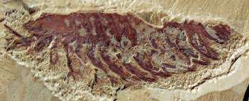
Phosphatization occurs when large quantities of phosphate are present, either in sea water or from the tissues of a decaying organism. In some cases, microbes that fed on the tissue control the phosphatization. Many soft tissues are preserved this way in the Burgess Shale. The phosphate comes from the tissue itself and when pH is low and oxygen is absent, it becomes the primary method of fossilization.
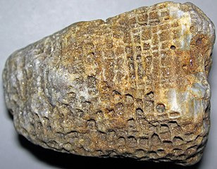
Silicification is one of the most common ways to fossilize something because silicates is the most common rock forming minerals in the crust. Silica often replaces other minerals that have dissolved out such as calcite shells. This is usually seen to preserve things like trilobites. It doesn't often fossilize soft tissue.

Another form of preservation found at least in the Burgess Shale is carbonaceous film. This occurs when something is buried under several layers of sediment and diagenetically altered (in this case by heat and pressure brought on by compaction) and the animal lacks a hard skeleton or shell.
When we look at quarry locations on a paleo map,

and examine the rocks, we see that they lived and died in the right place at the right time (if the taphonomic and preservation bias don't lead us astray).

The Burgess Shale beds were deposited at the base of a cliff of calcareous reefs below the depth agitated by waves during storms. The most widely accepted hypothesis for burial is that part if the reef became detached, slumped and transported rock and debris several kilometers and quickly burying anything in its path.

On the other hand, the Maotianshan Shale was probably buried periodically under turbidity currents, basically an underwater mass wasting event. This is why we don't build our homes on old landslide deposits kids.

The Sirius Passet lagerstatte of Greenland was yet a different environment close to the boundary of an oxygen minimum zone according to geochemical analysis. It is thought that the original preservation was phosphatization that was later altered to silica by low grade metamorphism during the Devonian Period mountain-building events.
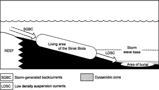
Finally, we have the Sinsk Biota of Siberia which inhabited an open marine basin where storms created back currents that sent many animals off into the oxygen depleted depths below. Anoxic conditions prevent growth of microbes that would normally decay flesh allowing soft tissues to preserve.
Now, it is also important to note that oftentimes, parts labeled soft tissue are not necessarily as soft as you believe. Take keratin for example which makes up nails, hair, feathers and sheaths over horns. It's not really that soft in some cases but it is softer than bone which makes it harder to preserve.
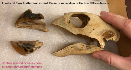
Whether we mean keratin or chitin (a natural polymer used to strengthen fungi and invertebrates) or internal organs which really are soft tissues, the Cambrian lagerstatten really are something else.
#paleontology#fossils#geology#mineralogy#fossilization#preservation#taphonomy#paleoecology#cambrian period#cambrian explosion
61 notes
·
View notes
Text
Spectember D29: Speculative Biome

Is not an oddity for geologists to look at some strange landscape formations, many caused by singular events or just by erosion, but the most particularly perplexing ones have been made by what is not considered to be a thing from this world...
North America seems to be dotted with dozens of these structures and the remains of already fallen ones, looking like gigantic towers of more than a kilometer in height, structured like a strange tree shaped form, it rises like a testament of the biggest terrestrial organism known, a monster tree made of stone and shaped by the millions of years of constant growth by part of a singular organism.
In Wyoming there is the most intact and oldest specimen of such beings, bein nicknamed Heaven’s Tower, unique megaorganisms formed by thousands of individual slime like organisms that behave like a stromatolite as it accumulate over layers over layers of sediment and material it built its structure, the way it do it seems to comprehend a system of vessels that transport the material from the terrain, often hollowing the terrain below forming a large cave chamber system that accumulate water and organic matter, preserve itself from erosion protected by a microbial layer product of the same organism. The tower seems to often renovate itself by the use of a special slime covering every century based on studies of change of texture and viscosity in the tower surface, but from what accounts on different expeditions into the inner cave system denote that the whole Tower formed dozens of millions of years ago, from mining expeditions around the chamber as well drilling in the main structure it was found it preserved a decent amount of data in the form of layers created by the accumulation of minerals by the slime into the main structure like a terrestrial stromatolite, this giving a possible date of the formation of the original tree around the late Eocene or early Oligocene.
As well seems to be every 5 to 10 million years there is a process that allow the introduction of surface fauna that always ends up into the lower chamber, to be eventually isolated which seems to last for few million years until there is a occurring a total extinction of the inner fauna, caused by the replacement and collapse of a old layer as its being replaced by a new one of almost 20 m of thickness, so far from fossil record the last breach occurred around the late Pliocene, isolating the fauna that lived upon that time.
The way one of the Heaven’s Tower specimen grow or originate is pretty much unknown for the very long span of time it takes to even start forming, is believe one of these might find a specific and rich place to feed its structure, more or less an old volcanic region and slowly accumulate to form the megastructure that feed symbiotically by chemosynthesis from the igneous rocks and photosynthesis, as well there has been identified fossil remains of older already fallen Towers that also expose similar patterns of growing. The Heaven’s Tower of Wyoming is the last intact structure as many seems to have been destroyed by the last ice age, and will take millions of years to recover, this itself is a testament of a paradoxical being that is still investigated, as this being for many accounts seems to not share any significant relationship of any living organisms.
303 notes
·
View notes
Note
I am watching a video with criticism of geographical determinism in worldbuilding and realized that I don't really remember seeing any fictional stereotypic merchant state that relies on rivers.
Norse and Rus were whom I had in mind, but to my knowledge British and Japanese people also heavily utilized rivers for trade and I would be very surprised if Ancient Chinese people didn't.
I don't know about history of First Nations of North America and did they have trade in our understanding, but I heard that river system of North America is so convenient that the entire 19th century demand for transportation could have been covered by it alone, without trains.
Just some ideas
Freshwater systems are woefully underused in worldbuilding. The other day I was reading about the history of my region and I was amazed at how big and sophisticated native canoes were in the Paraná, the Paraguay and the Amazonas, and how virtually nobody talks about it. We are talking about ships that could hold about 30 people and some were bigger than Columbus caravels. For centuries into the colonial era, the Spanish and Portuguese hired or pressed into service native navigators for the rivers which were though to navigate as a sea. Still before that, they were the major arteries of commerce and trade through the continent, this is well known. Even Patagonian goods are reported in Corrientes (North of Argentina) which indicates that trade there got very far. As for the Chinese, not only rivers were important to the but also they boasted an amazing canal system but that's about all I know.
One thing I learned recently about rivers and cities is that cities were often founded on the side of rivers, yes, but almost never at their mouth. Look for example at Paris, Rome, London, the Egyptian capitals. They were founded by the river, but the mouth of the river next to the sea is where the delta is, and deltas always change and flood, carrying mud and slit, they aren't good places to build at all. Good river cities are built in the 'deep side' of the river where you can build ports, not in the side where sediment accumulates. Another issue with river cities are marshlands. For example, I remember reading that the marshlands of ancient Rome were drained at great cost. Ancient peoples knew that marshes were 'unsanitary' even if they didn't know why (it's because they host mosquitos and parasites, not because of anything bad wetlands have on itself) and they had to deal with them. There are some exceptions to this, like Venice which was basically built on a marshland (or the Netherlands).
And indeed rivers were (and still are! I see ships going up and down the Paraná every weekend!) a very efficient way of transportation. There's lots about it written in Europe, but river barges were basically the railroads of their time. Before the advent of railroads, people in Europe (and China) weren't thinking roads, but canals, the French built a lot of canals at great expense which became obsolete later by railroad.
Unfortunately the sources about river canoes and transportation in America (continent) are often tucked away in papers and history books, there really isn't that much accessible literature and illustrations about it. Which is a goddamn shame because learning about native canoes bigger than Spanish caravels (and they were still building them in Paraguay and Argentina during colonial times, according to my sources) blew my mind.
70 notes
·
View notes
Text
Local Car Washed For The First Time In Nearly Two Years
After over a year of neglect and several months of gridlock in local government over budget allocations for the matter, anonymusbosch's car's interior was washed today. Asked for comment on what finally allowed the council to come to agreement on this desperately-needed measure, Bosch responded, "Well, it's been overdue for a while, but the recent exposure of nearly the entire interior to urushiol increased the urgency of finding a fix. The health of our constituents is a top priority for the council." (Urushiol is the oil found in poison oak and poison ivy and can cause itching and burning lesions upon contact; the oils can remain on fabrics for weeks.)
Given that this vehicle is primarily used for transporting heavy and bulky objects and for transporting personnel who have come in contact with poison oak, why was the matter not addressed sooner? A spokesperson for Bosch responded, "Frankly, we haven't had the equipment to deal with this, and we've never seen an urushiol dermatitis incident in the time we've had this car. We've been attributing that to better precautionary measures about second- and third-hand exposure. With the recent outbreak, we've been able to justify to the county treasurer the bond measure used to finance the remediation project."
An aide at the councilmember's office provided further detail. "When we originally proposed a remediation project, the cost estimate was nearly $200 for a full interior detailing. That wasn't something our local taxpayers were prepared to support and frankly thinking about spending $200 for someone to clean our car made us nauseous. At the same time, we don't have a wet-dry vacuum, so we weren't prepared to lead a remediation project ourselves. Thankfully we were tipped off to a more cost-effective option that has saved our taxpayers over $150."
A source who asked to remain unnamed listed the total dollar amount spent as "like 45 bucks" and said that "but like ten whole dollars went into the vacuum at a gas station because this fucker had straight up gravel all over the car. Completely irresponsible." The source added, "And they didn't even get all the sand out. Next time they might as well turn the car upside down and shake it." Eyewitnesses corroborated the source's price estimates, saying that a spot cleaner could be rented at the local Safeway for $29.99 for four hours and that the councilmember had been spotted loitering near the customer service desk there earlier today.
"We're happy to report that the councilmember has the financial considerations of the district's residents close at heart," said Bosch's spokesperson when asked for comment on the vacuum expenditure. "While the vacuuming portion of the remediation project went slightly over budget, we recouped an additional $12.99 by opting for laundry detergent instead of buying an entire container of carpet cleaner. We take these matters seriously."
An independent auditor who assessed the results of the remediation effort said that the car's interior was "not perfect, but, like, not narsty. There was gunk in all the corners and there isn't gunk now, or there's less gunk, and there also isn't a thin layer of sediment on everything either." The auditor noted that previous violations, like "a piece of tape that had been on the steering wheel for literally three years" and "four-month-old parking receipts" had been removed. "The urushiol was the highest priority, but it is also nice to see some of the lower-priority code violations addressed here as well," the auditor said.
When asked about whether the council would make vehicle cleanings a part of its standard services to the county or include them as a line item in next year's budget, Bosch replied, "Let's focus on the victories here. This was a collaborative effort that took several months of negotiations. I'd love to see support for it across the council, but I don't want to overpromise and underdeliver." Our reporter reminded Bosch that some cities support vehicle cleanings on a yearly or even quarterly basis. Maybe, like, just using the gas station vacuum once in a while? Bosch declined to comment. The Times also asked Bosch's office if the momentum from this victory for public health and transportation might be used to fix the apartment's bike storage rack or to schedule an appointment to replace the worn and thinning tires. "Our office has no further comment at this time," an aide replied. "And shut up about the tires. We'll get around to it."
After what it's taken to clean the interior, one can only hope.
#posts that get written in my head while i am filling my watering can with soap and water to clean off the hard surfaces in the interior#bc i don't know where a bucket is
15 notes
·
View notes
Text
Tracking Coastal Sediment Loss

Shorelines rely on an influx of sediment to counter what's lost to erosion by waves and currents. But tracking that sediment flux is challenging in coastal regions where salt, waves, and storms batter delicate instruments. (Image credit: NASA; research credit: W. Teng et al.; via Eos) Read the full article
#erosion#fluid dynamics#geophysics#physics#planetary science#satellite image#science#sediment transport#sedimentation
70 notes
·
View notes
Text
Mangroves. Estuaries. Shorelines where land meets water. Fluidity and porousness of boundaries. Imposition of imperial, colonial, European property law and the “fiction” of solid borders. Profit extraction from property, the “legal magic” of creating permanent borders, and the destruction of coastal forest-worlds.
---
[T]his tropical coastal ecology is a site of continual refiguration: neither sea nor land, neither river nor sea, bearing neither salty nor fresh water [...]. The mangrove has been prone to confused definitions, [...] also a complex coastal ecosystem in itself. With these hybrid conditions of “belonging,” the mangrove lends itself to helping us think through the present-day schematic of Euro-American crises [...]. Its polymorphous personality as a sediment-carrier, land-builder, defender of numerous life forms [...] renders the mangrove a fascinating study in the biopolitics of selfhood. [...] The Sundarbans covers an area of 10,000 square kilometers of intertidal zones between parts of southwestern Bangladesh and the state of West Bengal in India. The largest mangrove forest in the world [...]. As a landscape, the Sundarbans is marked by unfixity, since its intertidal nature places it between appearance and disappearance -- with islands being submerged overnight. [...] [T]heir porous quality does not allow for clear border-making. In reading [...] satellite image[ry] of the Sundarbans, produced by what is said to be “the most stable, best characterized Earth observation instrument ever placed in orbit,” we are met with the trembling instability of borders. [...] [H]ere the coastline becomes indiscernible as a single entity. The legal vexations of such amphibious and obtuse terrain become pronounced in sea-rights cases, wherein border-making becomes the necessity of tenure. Forming rulings over such zones lays legality prone to paradox. In the Blue Mud Bay case, heard by the High Court of Australia in 2008, a legal body was called upon to make a determination regarding the shifting geography of a mangrove coastal region. In the final ruling the aboriginal Yolgnu claimants were successful, with the court ruling that the column of tidal water lying above land should be regarded no differently from the land itself. Thus the court’s attempt to encompass Dholupuyngu cosmology and “aqueography” occasioned a legal magic transforming water flow into the fixity of “land.” [...] The mangrove line is, hence, one of sedimentary reclamation rather than clear political divisions of terra firma. In mangrove zones, human determinations become ghosts.
Text by: Natasha Ginwala and Vivian Ziherl. “Sensing Grounds: Mangroves, Unauthentic Belonging, Extra-Territoriality.” e-flux Journal Issue #45. May 2013.
---
Traveling through Bengal in the eighteenth century, [...] [travelers] saw a highly sophisticated water-based economy -- the blessing of rivers [...]. The rivers were not just channels of water; they carried a thriving trade, transporting people and goods from one part of the delta to another. [...] Bengal’s essential character as a fluid landscape was changed during the colonial times through legal interventions that were aimed at stabilizing lands and waters, at creating permanent boundaries between them, and at privileging land over water, in a land of shifting river courses, inundated irrigation, and river-based life. Such a separation of land and water was made possible not just by physical constructions but first and foremost by engineering a legal framework. [...] BADA, which stands for the Bengal Alluvion and Diluvion Act, a law passed by the colonial British rulers in 1825 [...]. Nature here represents a borderless world, or at best one in which borders are not fixed lines on the ground demarcating a territory, but are negotiated spaces or zones. Such “liminal spaces” comprise “not [only] lines of separation but zones of interaction…transformation, transgression, and possibility” [...]. Current boundaries of land and water are as much products of history as nature and the colonial rule of Bengal played a key role in changing the ideas and valuations of both. [...] [R]ivers do not always flow along a certain route [...]. The laws that the colonial British brought to Bengal, however, were founded upon the thinking of land as being fixed in place. [...] To entrench the system, the Permanent Settlement of 1793 created zamindars (or landlords) “in perpetuity” -- meaning for good. The system was aimed at reducing the complexities of revenue collection due to erratically shifting lands and unpredictable harvests in a monsoon-dependent area [...]. From a riverine community, within a hundred years, Bengal was transformed into a land-based community.
Text by: Kuntala Lahiri-Dutt. “Commodified Land, Dangerous Water: Colonial Perceptions of Riverine Bengal.” RCC Perspectives, no. 3, 17-22. 2014.
---
[A]t the shore, where the boundary between land and water is so often muddied [...] terrestrial principles of Western private property regimes feel like fictions [...]. Shorelines, indeed, do much to trouble the neat boundaries, borders […] of the colonial imaginary […]. And so thinking about shallows necessitates attention to the multiplicity of water, and the ways that tides, rivers, storm clouds, tide pools, and aquifers converse with the ocean [...]. For Kanaka Maoli, the muliwai, or estuary, best theorizes shoreline dynamics: It is not only where land and water mix, but also where different kinds of waters mix. Sea and river water mingle together to produce the brackish conditions that tenderly support certain plant and aquatic lives. [...] As Philipp Schorch and Noelle M.K.Y. Kahanu explain, the muliwai ebbs and flows with the tide, changing shape and form daily and seasonally. In metaphorical terms, the muliwai is a location and state of dissonance [...], but it is not “a space in between,” rather, it is its own space, a territory unique in each circumstance, depending the size and strength or a recent hard rain. […] [T]he muliwai [...] as a conditional state [...] undoes territorial logics. [...] It is not a space of exception. Rather, it is where we are reminded that places are never fixed or pure or static. Chamorro poet Craig Santos Perez reminds us in his critique of US territorialism that “territorialities are shifting currents, not irreducible elements.” If fixity and containment limit, by design, how futures might be imagined beyond property, then the muliwai envisions decolonial spaces as ones of tenderness, care, and interdependence. [...] Because water has the potential to trouble the boundaries of humanness, it may furthermore push us to think through […] categorical differences […], to consider the colonial mechanisms that produced hierarchies of bodies to begin with [...].
Text by: Hi’ilei Julia Hobart. “On Oceanic Fugitivity.” Ways of Water series, Items, Social Science Research Council. Published online 29 September 2020.
#abolition#ecology#landscape#imperial#colonial#tidalectics#caribbean#archipelagic thinking#wetlands#mangroves#estuaries shoals swamps deltas etc#indigenous#ecologies#geographic imaginaries#carceral geography
169 notes
·
View notes
Text


Rocks collected on Mars hold key to water and perhaps life on the planet. Bring them back to Earth.
Only Earth-based analysis of sediments gathered by rover can retrieve clues to Mars' water history
Over the course of nearly five months in 2022, NASA's Perseverance rover collected rock samples from Mars that could rewrite the history of water on the Red Planet and even contain evidence for past life on Mars.
But the information they contain can't be extracted without more detailed analysis on Earth, which requires a new mission to the planet to retrieve the samples and bring them back. Scientists hope to have the samples on Earth by 2033, though NASA's sample return mission may be delayed.
"These samples are the reason why our mission was flown," said paper co-author David Shuster, professor of earth and planetary science at the University of California, Berkeley, and a member of NASA’s science team for sample collection. "This is exactly what everyone was hoping to accomplish. And we've accomplished it. These are what we went looking for."
The critical importance of these rocks, sampled from river deposits in a dried-up lake that once filled a crater called Jezero, is detailed in a study to be published Aug. 14 in AGU Advances, a journal of the American Geophysical Union.
"These are the first and only sedimentary rocks that have been studied and collected from a planet other than Earth," said paper co-author David Shuster, professor of earth and planetary science at the University of California, Berkeley, and a member of NASA’s science team for sample collection. "Sedimentary rocks are important because they were transported by water, deposited into a standing body of water and subsequently modified by chemistry that involved liquid water on the surface of Mars at some point in the past. The whole reason that we came to Jezero was to study this sort of rock type. These are absolutely fantastic samples for the overarching objectives of the mission."
Shuster is co-author of the paper with first author Tanja Bosak, a geobiologist at the Massachusetts Institute of Technology (MIT) in Cambridge.
"These rock cores are likely the oldest materials sampled from any known environment that may have supported life," Bosak said. "When we bring them back to Earth, they can tell us so much about when, why and for how long Mars contained liquid water, and whether some organic, prebiotic and potentially even biological evolution may have taken place on that planet."
Significantly, some of the samples contain very fine-grained sediments that are the most likely type of rock to retain evidence of past microbial life on Mars — if there ever was or is life on the planet.
"Liquid water is a key element in all of this because it is the key ingredient for biological activity, as far as we understand it," said Shuster, a geochemist. "Fine-grained sedimentary rocks on Earth are those that are most likely to preserve signatures of past biological activity, including organic molecules. That's why these samples are so important."
NASA announced on July 25 that Perseverance had collected new rock samples from an outcrop named Cheyava Falls that also might contain signs of past life on Mars. The rover's scientific instruments detected evidence of organic molecules, while "leopard spot" inclusions in the rocks are similar to features that on Earth are often associated with fossilized microbial life.
In a statement, Ken Farley, Perseverance project scientist at Caltech, said, “Scientifically, Perseverance has nothing more to give. To fully understand what really happened in that Martian river valley at Jezero crater billions of years ago, we’d want to bring the Cheyava Falls sample back to Earth, so it can be studied with the powerful instruments available in laboratories.”
Sediments hold the answers
Shuster noted that Jezero and the fan of sediments left behind by the river that once flowed into it likely formed 3.5 billion years ago. That abundant water is now gone, either trapped underground or lost to space. But Mars was wet at a time when life on Earth — in the form of microbes — was already everywhere.
"Life was doing its thing on Earth at that point in time, 3.5 billion years ago," he said. "The basic question is: Was life also doing its thing on Mars at that point in time?"
"Anywhere on Earth over the last 3.5 billion years, if you give me the scenario of a river flowing into a crater transporting materials to a standing body of water, biology would have taken hold there and left its mark, in one way or another," Shuster said. "And in the fine-grained sediment, specifically, we would have a very good chance of recording that biology in the laboratory observations that we can make on that material on Earth."
Shuster and Bosak acknowledge that the organic analysis equipment aboard the rover did not detect organic molecules in the four samples from the sedimentary fan. Organic molecules are used and produced by the type of life we're familiar with on Earth, though their presence is not unequivocal evidence of life.
"We did not clearly observe organic compounds in these key samples," Shuster said. "But just because that instrument did not detect organic compounds does not mean that they are not in these samples. It just means they weren't at a concentration detectable by the rover instrumentation in those particular rocks."
To date, Perseverance has collected a total of 25 samples, including duplicates and atmospheric samples, plus three "witness tubes" that capture possible contaminants around the rover. Eight duplicate rock samples plus an atmospheric sample and witness tube were deposited in the so-called Three Forks cache on the surface of Jezero as a backup in case the rover suffers problems and the onboard samples can't be retrieved. The other 15 samples — including the Cheyava Falls sample collected July 21 — remain aboard the rover awaiting recovery.
Shuster was part of a team that analyzed the first eight rock samples collected, two from each site on the crater floor, all of which were igneous rocks likely created when a meteor impact smashed into the surface and excavated the crater. Those results were reported in a 2023 paper, based on analyses by the instruments aboard Perseverance.
The new paper is an analysis of seven more samples, three of them duplicates now cached on Mars' surface, collected between July 7 and November 29 of 2022 from the front of the western sediment fan in Jezero. Bosak, Shuster and their colleagues found the rocks to be composed mostly of sandstone and mudstone, all created by fluvial processes.
"Perseverance encountered aqueously deposited sedimentary rocks at the front, top and margin of the western Jezero fan and collected a sample suite composed of eight carbonate-bearing sandstones, a sulfate-rich mudstone, a sulfate-rich sandstone, a sand-pebble conglomerate," Bosak said. "The rocks collected at the fan front are the oldest, whereas the rocks collected at the fan top are likely the youngest rocks produced during aqueous activity and sediment deposition in the western fan."
While Bosak is most interested in possible biosignatures in the fine-grained sediments, the coarse-grained sediments also contain key information about water on Mars, Shuster said. Though less likely to preserve organic matter or potential biological materials, they contain carbonate materials and detritus washed from upstream by the now-vanished river. They thus could help determine when water actually flowed on Mars, the main emphasis of Shuster's own research.
"With lab analysis of those detrital minerals, we could make quantitative statements about when the sediments were deposited and the chemistry of that water. What was the pH (acidity) of that water when those secondary phases precipitated? At what point in time was that chemical alteration taking place?" he said. "We have this combination of samples now in the sample suite that are going to enable us to understand the environmental conditions when the liquid water was flowing into the crater. When was that liquid water flowing into the crater? Was it intermittent?"
Answers to these questions rely upon analyses of the returned materials in terrestrial laboratories to uncover the organic, isotopic, chemical, morphological, geochronological and paleomagnetic information they record, the researchers emphasized.
"One of the most important planetary science objectives is to bring these samples back," Shuster said.
TOP IMAGE: Red hexagons mark the four sites where the Perseverance rover collected rock samples around the sediment fan in Jezero crater in 2022. Credit NASA
LOWER IMAGE: NASA’s Perseverance rover puts its robotic arm to work around a rocky outcrop called “Skinner Ridge” in Mars’ Jezero Crater. Composed of multiple images, this mosaic shows layered sedimentary rocks in the face of a cliff in the delta, as well as one of the locations where the rover abraded a circular patch to analyze a rock’s composition. Credit NASA/JPL-Caltech/ASU/MSSS
18 notes
·
View notes
Text

Radioactive Waste Disposal Failures
Radioactive waste is often distinguished from hazardous waste due to the unique hazards radiation can pose - and proper transport, treatment, and disposal of radioactive waste can be just as crucial, if not more so. Many examples exist of improper disposal of radiation sources/radioactive waste, including at Lake Karachay, Mayapure, and Goiânia.
Lake Karachay, in the Ural mountains in Russia, is currently considered to be one of the most radioactive places on Earth. In the 1950s, the Soviet Union used it as a dumping ground for radioactive waste. In the 1960s, when a drought dried up portions of the lake, radioactive dust and dirt spread from the region. Eventually, concrete blocks were added to prevent sediment shifting and, in 2015, the lake was completely backfilled, turning the entire thing into a permanent (and dry) nuclear waste storage.
In 2010, in Mayapuri, Delhi, India, a research irradiator that had been unused for decades was sold at auction to a scrap dealer - without disclosing the hazards involved. The cobalt-60 source was broken into pieces, and eight people were ultimately hospitalized, with at least one known death.
Finally, in Goiânia, Goiás, Brazil, unsecured radiotherapy equipment was stolen from an abandoned hospital in 1987. The equipment was dismantled and sold and, ultimately, four deaths resulted from the theft, on top of hundreds of people being exposed to the radiation.
Sources/Further Reading: (Lake Karachay: Wikipedia, Science Times) (Mayapuri: Wikipedia, Hindustan Times) (Goiânia: Wikipedia, Nuclear Energy)
9 notes
·
View notes
Text
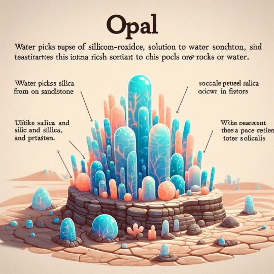
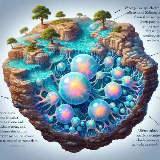
Opals are formed from a solution of silicon dioxide and water. Water picks up silica from sandstone and transports this silica-rich solution to cracks and voids in rocks or fossils. Unlike other gems, opal originates from the deposition of silica in specific locations12. These gems are formed from sediments of silica and water that break down and form a gelatinous mass that hardens over time3.
xpuigc


#OPALS#Opals are formed from a solution of silicon dioxide and water#Unlike other gems opal originates from the deposition of silica in specific locations12.#These gems are formed from sediments of silica and water that break down and form a gelatinous mass that hardens over time3#nature#fossils#geology#de-tot#pucex#xpuigc#xpuigc bloc
10 notes
·
View notes