#orographic
Explore tagged Tumblr posts
Text

Highlands, NC

Here, 13 miles from Highlands.
Amazing what elevation can do.
They are at 3,800 feet, we are at 2,200 feet.
8 notes
·
View notes
Text
Very big shout out to my friend who sends me pictures and videos of all the cool clouds he sees so that I can tell him what sort of cloud it is. Autism win
#he just send me a vid of a VERY cool cloud. it's like a mixture between a mammatus and a cumulus#part of it also looks like it's hit topopause and it's beginning to roll over the mountain so it might become orographic#brookie's bullshit
5 notes
·
View notes
Text
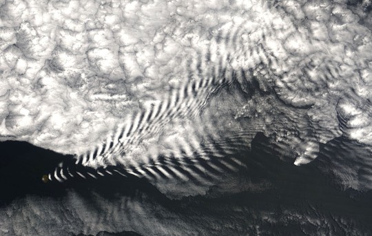
NASA satellite image of a wave cloud forming off of Amsterdam Island in the far southern Indian Ocean
3 notes
·
View notes
Text


old and new look inspiration
1 note
·
View note
Text
Weather Reports on the radio here:
A heat advisory is in affect for eastern Washington with highs in the 100s. There also is an elevated risk of fires due to dry conditions. Please try to stay indoors during midday and visit cooling stations as needed.
In western Washington the high will be in the upper 70s with a slight chance of rain.
0 notes
Text
Some Ecology Vocabulary

for your next poem/story
Autotroph - Any organism that is able to manufacture its own food; derive energy from inorganic sources (light or inorganic chemical reactions)
Benthic - Organisms that live on the bottom of the ocean
Biome - A community of plants & animals that occupy a distinct region; defined by climate and dominant vegetation: tundra, desert, grassland & forest; can be subdivided, i.e. boreal, temperate, tropical forests
Boreal forest - (also called Taiga) Largest terrestrial biome, characterized by having very cold winters and coniferous forests
Dessication - Mummification
Detritus - Accumulated organic debris from dead organisms
Detrivore - Any organism which obtains most of its nutrients from the detritus in an ecosystem
Disturbance - An event that alters the ecosystem, i.e. the plant community and possibly the physical environment; natural disturbances include fire, landslides, windthrow, insects, disease, etc. Levels of Disturbance:
Tree-level: affects single trees or small groups of trees
Stand-level: affecting large groups (many hectares) of trees (insect epidemic, hurricane, logging, wildfire)
Site-level: affecting the physical environment is a dramatic way that all life is lost and a new soil environment is created (lavaflow, glacier, landslide)
Planet-level: affecting the planet as a whole (big meteor, death star...)
Frugivore - Animal which primarily eats fruit
Groundwater - Water found underground as a result of rainfall, ice and snow melt, submerged rivers, lakes, and springs. This water often carries minerals. These minerals can accumulate in the remains of buried organisms and eventually cause fossilization.
Halophile - Organism which lives in areas of high salt concentration. These organisms must have special adaptations to permit them to survive under these conditions.
Limnology - The study of river system ecology and life
Orographic Lift - Occurs when an air mass moves over a mountain range, air cools, drops precipitation, then as air moves down the lee side it warms and creates a rain shadow
Pelagic - Organisms that swim through the ocean, and may rise to the surface, or sink to the bottom
Rain shadow - The dry region on the leeward side of a mountain range, where rainfall is noticeably less than on the windward side
Riparian - Having to do with the edges of streams or rivers
Saprophyte - Organism which feeds on dead and decaying organisms, allowing the nutrients to be recycled into the ecosystem. Fungi and bacteria are two groups with many important saprophytes.
Silvics - The study of the life history, characteristics and ecology of forest trees
Tolerance - The capacity/ability of an organism to endure (survive, withstand) adverse effects from unfavourable environmental conditions; the opposite of sensitivity
Upwelling - The raising of benthic nutrients to the surface waters. This occurs in regions where the flow of water brings currents of differing temperatures together, and increases productivity of the ecosystem.
Xeric - Describes an environment or habitat with little moisture; dry to very dry
Sources: 1 2 ⚜ More: Word Lists
#ecology#terminology#word list#science#writing reference#dark academia#studyblr#langblr#writeblr#spilled ink#light academia#literature#writers on tumblr#writing prompt#poetry#poets on tumblr#writing inspiration#writing inspo#writing ideas#creative writing#john frederick lewis#writing resources
77 notes
·
View notes
Note
hi i love your meteorological fiction project i think the paintings are absolutely stunning but you got me interested in clouds so: where did you learn about the different types, species, varieties etc?
Hello! Apologies for taking so long to reply, things have been quite hectic lately.
I'm so glad you like the reports, thank you so much!
I've previously given a few references, but I don't mind going a bit more in depth about this.
I only knew about a few basic cloud types back when I started. I just stumbled upon a basic cloud guide by Richard Hamblyn while I was in the library one day, and I pretty much went from there. Now, I tend to recommend a different book from the one I first got, if only because mine was a bit more of a collection of pictures.
The one I recommend is The Pocket Cloud Book by Richard Hamblyn, which has gotten an updated edition a couple years ago. It's great, it's cheap, it's small, but it's got all the basic things you might want as a beginner, and you can have it on you at all times so you can use it to identify clouds in the wild. I say this a lot, but I think it's the most important part in learning about clouds. Pictures are great, and they teach you a lot, but being outside and watching the clouds change makes a real difference, because they're always. changing. Cumulonimbus, for instance, look so wildly different from one stage to the next.
Now, there are also wonderful free resources here on the Internet. I favour these ones that I've given before:
What's This Cloud explains in simple terms the different types and subtypes of clouds. There are diagrams, identification lessons, a very helpful free e-book.
Cloud Appreciation Society is one of my favourite websites. It features a gallery of pictures submitted by observers from the whole wide world that you can easily sort through, though not every picture is tagged super thoroughly. There's also a message board, clouds-related news, and so on.
The International Cloud Atlas by the WMO is a treasure trove, and a great official source for meteorology. It goes in depth on all the meteorological phenomena that have been officially identified. Want to read about the orographic influence on clouds? Ohohoh, have fun on the International Cloud Atlas!
I'd also like to mention you can easily find PDFs of On the Modification of Clouds by Luke Howard (1803), an essay that exposes the clouds nomenclature that we still use to this day. It's kind of fascinating, and it's got lovely illustrations.
Overall though, it's a lot of trial and error. I still struggle a lot. I forget all the names sometimes. But it's fantastic, I love learning about clouds.
#flying-potato2#ask#answered ask#answer#faq#question#reference#long post#I hope this is helpful somehow!!
26 notes
·
View notes
Text
High obliquity (axial tilt) worlds are really very strange. The ice caps of terrestrial planets with substantial water inventories creep down from their high polar latitudes as you increase tilt, blanketing more and more of the surface in ice sheets right up until you reach a tipping point found somewhere around forty to fifty degrees. There, due to the way sunlight is distributed across the planet seasonally - like a sunbather turning over just twice a year - the ice caps suddenly migrate into a new configuration, hot polar summers driving the formation of an ice belt around the equator. We know Earth likely can't enter such a state (although a few papers claim otherwise) - the tidal influence of the Moon, coming in at just over one percent of the Earth's mass, is thought to damp down the spin-orbit resonances that drive axial wobble.
But then there's Mars with its two pebble-like asteroid-moons, axial tilt relatively free to wander compared to the Earth. From <20 to >50 degrees it lurches around on, as far as we can tell, a timescale of hundreds of kiloyears to a few megayears - really surprisingly short in geological time. Interestingly, there's evidence* in the paper above that those periods of higher 30-50+ degree obliquity have, taken cumulatively over the whole post-Noachian history of Mars, lasted for up to a billion years. It'd have been interesting if we got to see Mars during these relative ice ages, a Mars almost more white than red, or a Mars with its lowlands bisected by a great wall of ice... The (orographic?) snow west of the four big Tharsis volcanoes in the high-obliquity present-atmosphere model (bottom right) below is kind of fun I think.
Also kind of interesting that so much snow piles up on the high-altitude uplands in scenarios with more Earthlike atmospheric pressures (if not compositions), mostly independent of obliquity. Seems fairly plausible that you'd get a similar kind of scenario when terraforming Mars or Marslike exoplanets, ending up with deeply glaciated highlands feeding glacial rivers down into lakes and seas in the more temperate lowlands. It does things just a little more difficult though - ice is more reflective than dirt, and all that increased sunlight bounced back into space means you'd need to ramp up the heat you inject into the climate as you get into the pressure ranges where polar ice can sublimate into the atmosphere and fall as snow or risk atmospheric collapse... realistically of course you're doing that anyway with your soletta mirrors and all that. Food for thought, though.
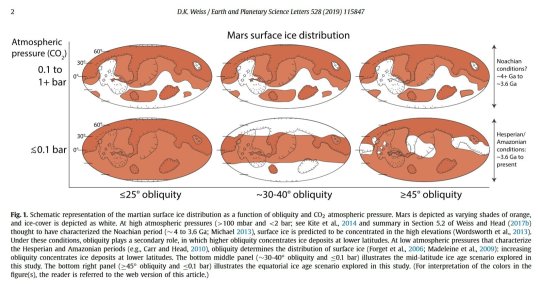
(*)The paper looks for a specific kind of crater that probably only forms when a meteor strikes an ice sheet, and finds a fair chunk of them down in the midlatitudes and equatorial regions.
32 notes
·
View notes
Text
I finally got around to compiling some of the extraneous, in-service-of-the-main-feature maps for the "Runaway to the Stars" Scud-planet commission that I thought were also worth showing, some because they reveal something unique about this planet's qualities, others because they're pretty, and mostly both. There's a good handful of those and a *lot* of explanatory text, so that's all below the cut.
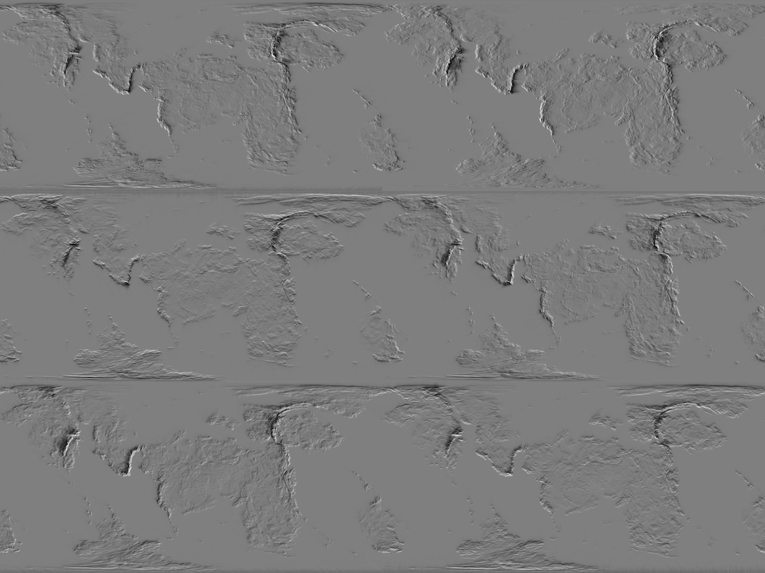
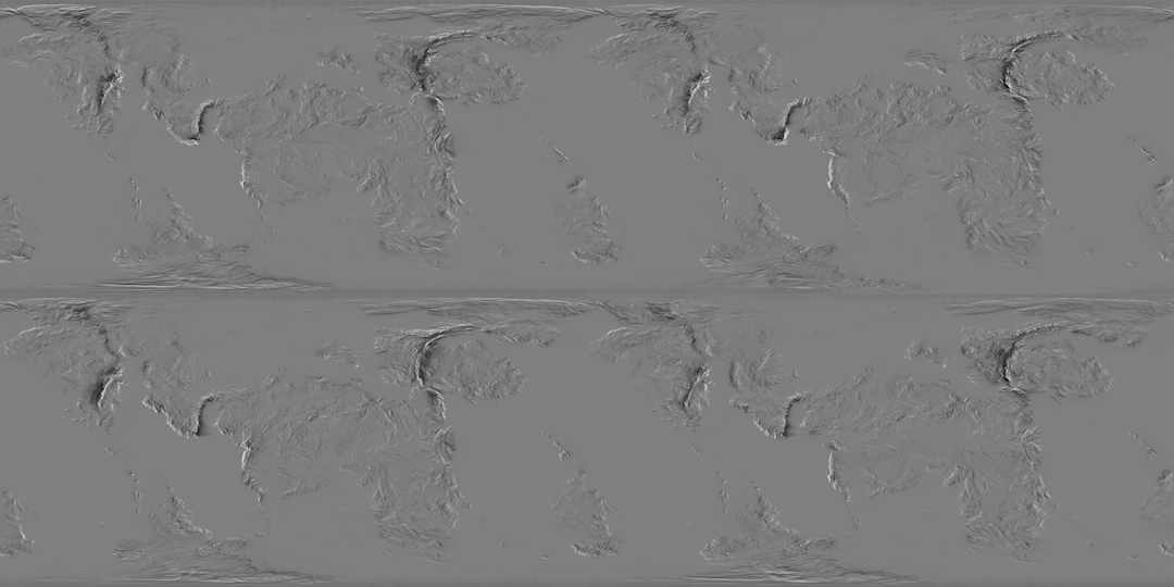
First we have the maps that bridge the gap between wind data and precipitation. This pair of animated maps demonstrates, first, the Orographic effect that would theoretically result from winds blowing in each of the eight cardinal directions across the planet's whole surface, and, second, the Orographic effects which are actually produced by the local prevailing winds for each season. For both of these, darker values mark where the topography prevents moist air from precipitating (a rain shadow, on the leeward side of a raised terrain feature) and lighter values show where the topography catches most of the airborne moisture before the wind blows over it (a rain-highlight, on the windward side of a raised feature).
__________
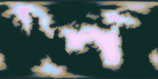
The first static map, looking like a meticulously customized Jawbreaker, roughly represents the inland distance over which air has to travel from various bodies of water (also accounting for vertical distance in the form of mountains and the sizes of the bodies of water providing the moist air), which is another factor in where rain is able to fall.
__________
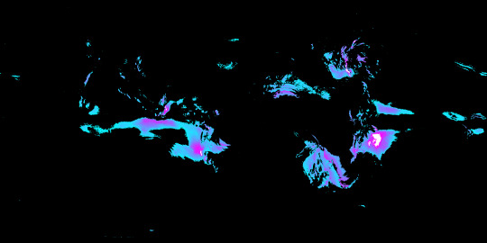
Another static map, included entirely for aesthetic reasons, demonstrates (in white) where at least ten times as much rain falls in the wettest month of summer as in the driest month of winter. The cyan end of the gradient represents where only 3 times as much rain falls, in that comparison. This was a step in figuring out what areas would qualify as Dry Winter (climate type Cw) in the climate zone maps, which ended up being completely nonexistent once all the other requirements of that climate type were measured for. All of the areas marked in white (meeting that 10x ratio requirement for Dry Winter) ended up falling under Arid or Semiarid instead.
__________
For comparison, *this* map shows (in cyan through magenta) where there is at least three times as much precipitation in the wettest month of winter as in the driest month of summer, one of the requirements for Mediterranean climate (or Dry Summer, climate type Cs). Not all of the marked areas ended up meeting all requirements for the final climate zone map, either, but at least *some* did, falling just outside the Arid/Semiarid areas.

__________
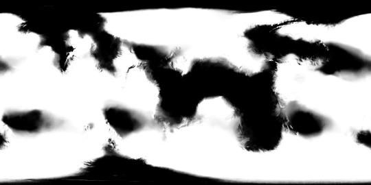
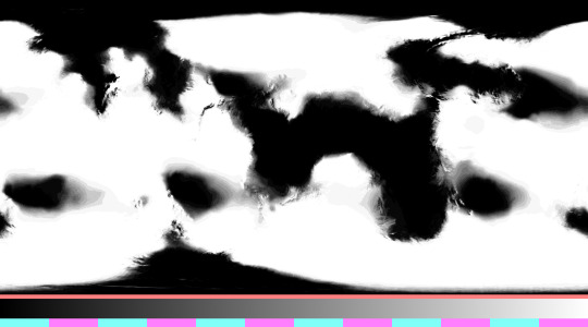
Another precipitation-related map, this one instrumental in figuring out vegetation density, demonstrates the reliability of significant rainfall. Specifically, this represents how many months in a row a given area receives at least 60 millimeters of precipitation per month, with areas in white receiving this amount for every month of the year, areas in black experiencing no months with that much rainfall, and shades of grey showing where this much rainfall persists for anywhere from one to eleven months in a row. The second map attached here shows that data broken down for the exact number of months.
__________
Next, here is a map that helped me find where Upwelling would occur seasonally. Since material from deeper waters is brought to the surface by the general movement of water *away from* the coasts, and since water is moved in that direction by winds blowing *perpendicular to* the coasts (counterclockwise for the northern hemisphere on a retrograde-spin planet like this, and clockwise for its southern hemisphere), it was crucial that I first determine what directions the coasts themselves were facing, with red marking coasts that face north, yellow for coasts that face west, cyan for coasts facing south, and blue for those facing east. This particular map was produced by taking a blurred elevation map of the shallows, using it as the displacement texture for a flat Plane in Blender, and pointing different colored lights at it from the eight cardinal directions.
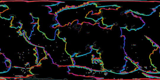
__________
One of the very last elements that I mapped out for this planet was the discharge of sediments from the rivers into seas and terminal lakes, which required a *lot* of steps. The first of these was to isolate the different major drainage basins that would deliver water to various sections of the coastal shallows, as seen in the first, multicolored map. In the second map, we see the surface areas of each of the drainage basins, in the third map we see the average density of vegetation within each basin, and in the final map I've combined this data to show the overall total amount of vegetation in each basin, which should roughly correlate with how much organic material ends up washing out to sea, since river discharge volume and vegetation density are both (largely) contingent on the same factor: precipitation.

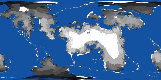
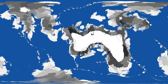

All told this is only a tiny fraction of the maps that were part of the overall pipeline. On Reddit you should be able to see these images in higher resolution, so I'm including a link to the corresponding post here
#digital painting#Photopea#mapmaking#imaginary maps#Blender#speculative climatology#Runaway to the Stars#RttS Scuds#alien planet#major post#commission#christopher maida artwork
16 notes
·
View notes
Note
dirt facts for the columbia river basin? 🤲
godddd the PNW has such interesting geology. There's a surprising amount of volcanic geology within the united states, but the majority of it is west of the rockies, and no place else is that more common than in the PNW. Geologists in the PNW are welcome to correct me, but as someone whose mostly worked in very predictable glacial geology or residuum from common marine sedimentary strata (limestone shale siltstone repeat repeat repeat -- hey karst!), my overwhelming impression of the PNW has been a region dominated geologically recent cataclysms which have dramatically reshaped the landscapes, and the Columbia River Basin has at least three different impacts that effect soil development as a result: the columbia flood basalts which stem from the yellowstone hot spot, the missoula floods at the end of the last ice age, and the influence of volcanic eruptions on the surrounding area from the cascades and the yellowstone hot spot.
The main thing I find interesting here however is one that is a little less than remarkable given the cataclysmic history of the region, and is far more mundane: the disparity in the landscape on either side of the cascades.

This is a somewhat remarkable observation on a flat image. In the space of 60 miles, the entire landscape transitions from a semi-arid landscape to one overflowing with greenery and vegetation. Driving west on I-84 produces landscapes that wouldn't be out of place in the rest of the arid west, Nevada, Idaho, Montana.
Of course, that is an illusion created by a flat image. Naturally, there is an entire mountain range in the way.

The imagery undersells it: this looks like a low range of hills, all too familiar to those of us who live out east and drive over rolling hills every day. The Columbia River Gorge, seen here curving off to the right beyond the Dalles, cuts deep through the Cascades and the high plateau built up by, you guessed it! All! Those! Flood Basalts!
This dramatic difference isn't just due to elevation changes, but is largely due to the infamous rain shadow effect that occurs in much of the PNW.
Brief detour to physics: pressure. In gasses, if temperature increases, pressure must increase (provided volume remains constant). If you've had a half an equation hanging out of your brain for the past 10 years from chemistry class, it's probably pV=nRT which describes this exact relationship. Anyways: if you take a bunch of moist air coming off the Pacific, and have winds blowing it up a hill, because it rises in elevation, atmosphere pressure decreases, so temperature of the front decreases as well and you get the PNW's infamous eternal rain. This entire effect is known as orographic lift.

And IN SPITE OF THIS! The soils aren't really all that different on either side of the range! They're primarily different in terms of weathering!
The agricultural soils to the east are rather plain, slightly developed soils which consist of drifts of dust deposited over thousands of years onto cracked basalt (floods again!). The same materials are present to the west, but because it rains so much more, they're much more developed, enough that silica, you know, the stuff Sand is made out of, has weathered and recemented within the soils, creating what's called a fragipan -- almost like a natural type of concrete!
Thanks!
#Lost my train of thought a bit there towards the end but ah well#loess and fragipans warrant a much bigger explanation later#dirtposting
6 notes
·
View notes
Text
I stare at the night sky. The mountain ridges framing the narrow valley are contours. There is no moon but there is an astonishing number of stars. A solitary orographic cloud slowly weaves its way through the night. Above it, you can catch glimpses of the Milky Way. Normally, it’s an endless, breathtaking scene, but now it makes me shudder involuntarily. The universe seems like a cold and hostile place, not meant for human life. Just like all these rocky and icy stairways to heaven that we keep trying to ascend. In the daytime there’s a deceptive calm and a sense of security, but then, when the sun disappears behind the horizon, the isolation descends on you, the clammy certainty that if you scream, there will be no one, absolutely no one, to hear you.
-- from Echo, by Thomas Olde Heuvelt (trans. Moshe Gilula)
4 notes
·
View notes
Note
Choose your favourite type of cloud and say why:

Thanks for the graph! I learned so many nouns from this, though I will probably forget them all an hour later lol From this graph, I will say nimbostratus because I think the name sounds cool :P
Outside of the graph, I will pick orograph clouds because they are pretty.

3 notes
·
View notes
Text

Lenticular Clouds Over Salar Aguas Calientes, Chile. Photo by Yuri Beletsky, 25 May '16. (In EPOD 16 June '16) Photographer's description: "These spectacular lenticular clouds were observed over Northern Chile, near Salar Aguas Calientes. They're illuminated here by the setting Sun. This was one of the most incredible scenes I've ever witnessed! When we arrived at the lake in the foreground, the wind was so strong (more than 55 mph or 88.5 kmph) that we had trouble just walking around. The strong airflow and available moisture in the wave crests over the mountains in the background allowed lenticular clouds to stack on top of each other. Orographic wave clouds were forming all afternoon, but it was the setting Sun that made the sky come alive, leaving us speechless."
#Yuri Beletsky#photography#lenticular clouds#Chile#cosmic skies & clouds#EPOD#Earth Science Picture of the Day
2 notes
·
View notes
Text
I stare at the night sky. The mountain ridges framing the narrow valley are contours. There is no moon but there is an astonishing number of stars. A solitary orographic cloud slowly weaves its way through the night. Above it, you can catch glimpses of the Milky Way. Normally, it’s an endless, breathtaking scene, but now it makes me shudder involuntarily. The universe seems like a cold and hostile place, not meant for human life. Just like all these rocky and icy stairways to heaven that we keep trying to ascend. In the daytime there’s a deceptive calm and a sense of security, but then, when the sun disappears behind the horizon, the isolation descends on you, the clammy certainty that if you scream, there will be no one, absolutely no one, to hear you.
-- from Echo, by Thomas Olde Heuvelt (trans. Moshe Gilula)
2 notes
·
View notes
Text
Your Blood that I Bleed
Hashtag_DriveBy
Summary:
Ezio said, “She is his; the Gift the Apple bestowed upon him.” Not knowledge and the ability to use it, as Altaïr had asked, or for renewed youth and purpose, as Ezio had. No, when holding the Apple and the ability to wish for anything he desired, Desmond had humbly asked for nothing more and nothing less than the smallest of companions. One that he knew. One that he’d lost, at some point in his too few years. One who was more than willing to cross time and space to be at his side again.
Live a Life or Die Trying
esama
Summary:
There's someone in Dracula's Castle who does not belong there
Stargate Brotherhood
esama
Summary:
In which there is a solar flare
Flowers For a Planet
esama
Summary:
There are flowers growing in the Grey.
Let me be without regret
WhisperingDarkness
Summary:
That time Desmond wore a white sheet (and also changed history).
Orographic Lifts
TimTheToaster (tabletoptime)
Summary:
Ezio wouldn’t say he had been expecting anything in particular, but if he had been, it certainly wouldn’t have been this. What he found, in the chamber where the glowing phantom of a goddess once spoke past him, was three figures splayed across the strange stone floor. All three were naked, and all three of them had wings. In which some people get answers and other people just have the Weirdest Day.
Figments of My Imagination
Aelwyn
Summary:
When Altaïr was a child, he had two imaginary friends. Both of them claimed to be from the future, and both of them were immensely interested in some stupid Codex he hadn’t written yet. When Ezio was a child, he had two imaginary friends. One of them was a famous Assassin who taught him everything his father tried to hide, and the other was from the future and wanted to know why he wore his hair like a girl. When Desmond was a child, he had two imaginary friends. Both of them were from the past, both of them legendary members of the Assassin’s Brotherhood. When Altaïr grew up, he wrote the stupid Codex and hated every minute of it because he knew they’d be smug. When Ezio was a teenager, everything he’d learned from Altaïr helped him save his family even though his father had kept him in the dark. When Desmond was a child, his father told him to grow up and stop believing in fairy tales. When Ezio grew up, he followed Altaïr’s Codex and was told that he was a messenger for Desmond. When Desmond was a teenager, he ran away from the Farm. When Desmond grew up, he realized his imaginary friends weren’t so imaginary after all.
Total System Overhaul
esama
Summary:
In which Shen Qingqiu gets a new System
I've fallen back into the Assassins Creed fandom and decided to share my favs. (there was one more but for the life of me I cannot find it)
4 notes
·
View notes
