#northern alberta railways
Explore tagged Tumblr posts
Visit Tumblr Blog
Explore Tumblr blogs with no restrictions, modern design and the best experience.
Last Seen Tumblr Blogs


Fun Fact
28.6 is the average number of monthly visits per US mobile user.
Text

Wrecked CNR steam locomotive No. 5115 sits nose-to-nose with NAR 202 after a head-on collision near Carbondale, Alberta, that led to a tank car explosion, the destruction of the nearby train station, four deaths, and nineteen injuries, 1959. Photo from the Provincial Archives of Alberta, via the Carbondale Railway Station
#alberta#northern alberta railways#steam locomotive#gmd gp9#passenger rail#collision#derailment#railroad history
10 notes
·
View notes
Text

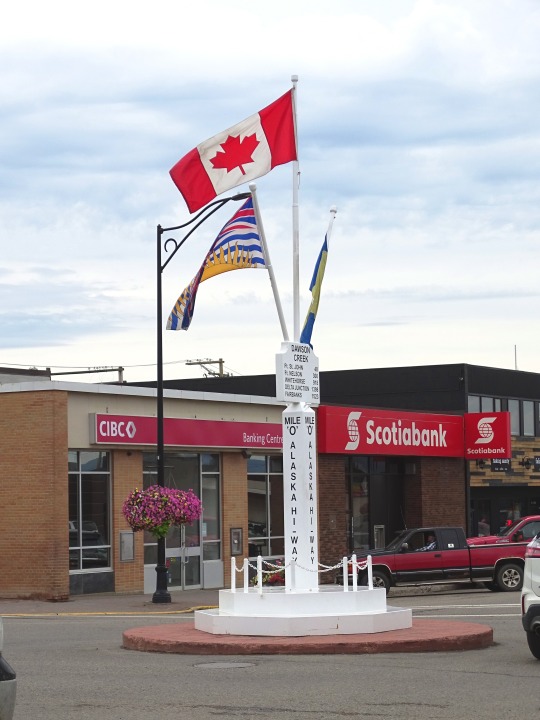

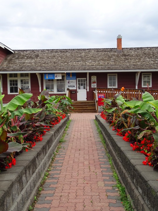

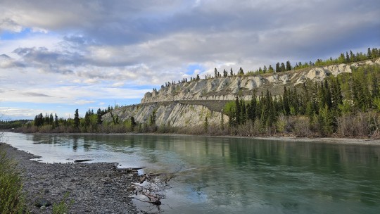
Dawson Creek, BC (No. 3)
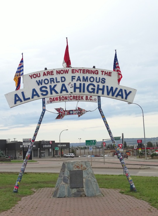
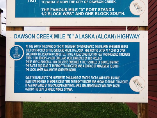
Upon entering the war, the United States decided to build a transportation corridor to connect the US mainland to Alaska. In 1942, thousands of US Army personnel, engineers, and contractors poured into the city – the terminal of rail transport – to construct the Alaska Highway. The highway was completed in less than a year; even after the workers involved in its construction departed, population and economic growth continued. In February 1943, a major fire and explosion in a livery barn, packed with road-building supplies including dynamite, caused serious damage to the center of town; five people were killed and 150 injured. Dawson Creek became a RCAF station during WWII, in September 1944. The station disbanded in March 1946.
By 1951, Dawson Creek had more than 3,500 residents. In 1952, the John Hart Highway linked the town to the rest of the British Columbia Interior and Lower Mainland through the Rocky Mountains; a new southbound route, known locally as Tupper Highway, made the town a crossroads with neighbouring Alberta. The next year, western Canada's largest propane gas plant was built and federal government offices were established in town. In 1958, the extension of the Pacific Great Eastern Railway to the Peace from Prince George was completed, and the village was re-incorporated as a city. Between 1951 and 1961, the population of Dawson Creek more than tripled. The RCAF center reemerged on October 1, 1956 and was declared functional in 1958. It was disbanded a final time in March 1964.
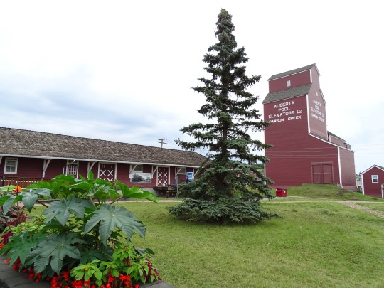
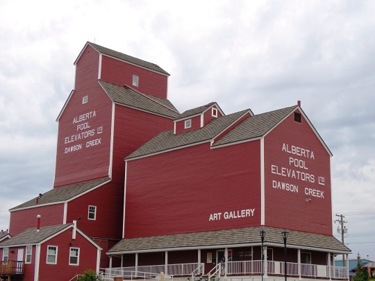
Growth slowed in the 1960s, with the population reaching its all-time high in 1966, but area population increased. In the 1970s, the provincial government moved its regional offices from Pouce Coupe to the city, Northern Lights College opened a Dawson Creek campus, and the Dawson Creek Mall was constructed. Several modern grain elevators were built, and the town's five wooden grain elevators, nicknamed "Elevator Row", were taken out of service. Only one of the historic elevators remains, converted to an art gallery. Since the 1970s, with the nearby town of Fort St. John attracting much of the area's industrial development and Grande Prairie becoming a commercial hub, the town's population and economy have not significantly increased.
Since 1992, the city has undergone several boundary expansions. One expansion incorporated undeveloped land in the southeast for an industrial park and a Louisiana-Pacific Canada veneer factory. The city extended sewer and water lines to the location; however, the area was not developed and with the factory only half-built, L-P Canada abandoned its plans. A business making manufactured homes bought the factory and completed its development in 2005. Another expansion incorporated the existing oriented strand board factory in the northwest corner of the city, while further incorporations have included undeveloped land to the south and north.
Source: Wikipedia
#Dawson Creek Art Gallery#prairie elevator#Dawson Creek#NAR Station Museum#Visitor Centre#travel#original photography#vacation#tourist attraction#landmark#cityscape#architecture#British Columbia#summer 2023#Canada#Alaska Highway#NAR Park#Alcan Highway#downtown#northeastern British Columbia#BC#Alaska-Canadian Highway#street scene#Northern Alberta Railway Park#flora#flower#tree#log cabin#Mile Zero Post
4 notes
·
View notes
Note
You may have already made a post about this so sorry if so, but what are your headcanons regarding how Matt and Katya met? And how they kept touch over the years?
Love your content btw!!
Thank you! And actually, somehow, no one has asked me that on any of the blogs! I had to think and coalesce some thoughts. This got long so I am going to split it into two parts but their meeting!
The Trans-Canada railway was completed in the 1880s and finally opened up what was called the ‘last best west.’ Between the Canadian Rockies in the far west and the western edge of the woodlands that define eastern Canada in Manitoba, the prairies stretch out in what looks to a child of the eastern woodlands like a vast treeless void. Grasslands and steppes are incredibly ecologically important, but I am ethnically a clinker-built canoe lover, and they scare the shit out of me. Judging by settlement patterns, most French Canadians agreed. As the American West closed, some Americans were willing to join Canadians and take land ripped from indigenous peoples too. Alberta was a result. Concerned about American settlement, in 1896, the Dominion of Canada’s federal government coordinated with the foreign office of the British Empire to look for more settlers. At the same time, in what was then the Austro-Hungarian empire, Galicia was likely the poorest place in continental Europe, with the only other comparable example being famine-era Ireland. The other Ukrainian-speaking areas of the Austro-Hungarian empire (75-80 of that territory was held by the Russian Empire) weren’t much better off. Each government found a solution in the other. Britain, representing Anglo-dominated Canada, and the Austrians shook hands, and the flow began. The US saw the largest share of Eastern European immigration in this period, but the majority who sailed to Canada were Ukrainians. And even before immigration, the region's international ties were based on Canadian financial interests. So, what does this mean for Katya and Matt?
The scene I imagine is that while the powerful wheel and deal, two products of empire crossed paths. One of these meetings may have taken place during a summer folk festival. Girls wove wreaths of flowers into their hair and floated others down the river. Songs were sung, vodka and wine flowed, and dancers joined hands. While the Austrians and the British bargained, a young man not so far removed from his peasant roots and his own saint’s day celebrated with fire and river wandered into the edge of a valley clearing at the end of the longest day of the northern year. As a maple or spruce was decorated, the sun sank, and the last light of day fell like fire light onto a Carpathian river valley. Bonfires were lit. Against a world on fire, a child of the woodlands looked upon the silhouette of his future, crowned with birchwood silver woven into her braids. Katya sensed him, a being like herself from across the world and turned. She looked at him a long moment, with eyes belonging to a world since passed set in the face that would one day be the image that sprang into Matthew’s mind when he needed to summon a memory of home that would not cleave him in two. She bid him to approach and, with one gesture, changed their fates.
Later, he would find out she spoke the court French of his earliest years, but this night, there is only Katya’s outstretched hand and burning blue eyes reflecting fire and Matt’s fingers lacing into hers to spin in the dance of all the other young men and women. There is no discussion of soil and wheat, nor opportunity and affection. There is only alcohol, laughter, music, fire and spinning, his mouth full of her language, unknown but already familiar. There is only a lightening of her eyes as she enjoys herself, her head flung back in laughter as he chokes on pear horilka stronger and sweeter than any whiskey he’s ever made. Her wreath topples out of her hair, and she bursts into laughter as he snatches it up and runs, calling over his shoulder, and she hikes up her skirts and follows, hand outstretched, only to grasp onto him and run, stride long and confident as they leap together to make it over the bonfire.
Still, together, hands clasped, his right her and left and left touching the laurel wreath, the last symbol she indulges from her Varangian roots. Eye contact, a significance, a weight that will one day balance the heaviness of history. She will press his heart into the shape of hers with that weight. He will give it back in every way he can, the ballast of whatever love she’ll let him give. But for now, in the last light of day, there is only a young man and a young woman hand in hand, circling a fire under a night sky. Here, they are under a star-streaked Milky Way that gives way to a mead moon rising over the mountains. Someday, save them; that moon will be the only witness to this night when mortality leaves alive only a man, a woman, and their most human memory.
#the ask box || probis pateo#canukr#katya || бо лишало на серці сліди#matthew || my country is winter#katya and matt || the soil of our souls#hws ukraine#hws canada
51 notes
·
View notes
Video
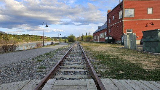
RDCs at Dawson Creek por Joe McMillan Por Flickr: In 1987, the West Coast Railfans Association (WCRA), a Canadian group, sponsored a RDC tour of the entire BCR. For about $600, we would be treated to seven solid days of train riding, lodging, meals, etc. Steve and I, plus some of our friends, couldn't get our checks mailed in fast enough. What a bargain!! We were to tour the main line from North Vancouver to Fort Nelson, a distance of 979.4 miles, plus all the branches, except the Dease Lake Extension beyond St. James, which was closed by then. (As noted earlier, Steve and I had already done the line west of St. James.) We left North Van on September 13, 1987, and returned on September 19th. We spent each night in a town along the way. The town usually had a banquet for us and put on an after-dinner show. We were assigned three BCR RDCs for our trip and they stayed with us the entire time. Our three cars were coupled to BCR Train 2 at Lillooet on the last day, so we had five RDCs that day. On September 15, we traveled the 61.1-mile Dawson Creek Subdivision from Chetwynd to Dawson Creek, B.C., The cars are spotted next to the Northern Alberta Railway station shortly before our departure back to Chetwynd. We tied up that night at Fort St. John–––photo by Joe McMillan with Steve Patterson and a bunch of other friends.
2 notes
·
View notes
Text
An epilogue
Canada was great and in many ways not how we expected it to be. For one thing, the weather was good, warm, sunny and dry. We were able to join in the celebrations of Canada Day in shorts beside the lake in the heat. Constitution Act of 1867 signed off by Queen Victoria created Canada, formally joining several colonies into a single, unified, semi-independent Dominion of Canada. Essentially, Canada became a self-governing dominion within the British Empire on the 1st July 156 years ago. And to some extent, Canada as an entity was something we found odd. Why did it never join the USA (some say Alberta would like to become the 51st State of the USA), why did the US buy Alaska above Canada in 1867, incidentally the same year Canada was created, and why do half the people still speak French despite the French being licked by the British in the Battle of Quebec in 1759? Well I don't think anyone knows. It's odd thinking of a French speaker as Canadian and not, well, French. The second largest country in the world and the longest border with another country in the world. Shoreline on 3 oceans and just 40 million or so population. The Rockies were like a massive version of the Lake District and Norwegian Fjords superimposed onto the Alps. Alaska reminded me very much of Norway. Equally stunning in its own way with tiny communities happily coexisting in their geographically imposed isolation with whales and fish as company but invaded regularly by vast armies of cruise ship guests many times in number greater than their own population. Canadians were lovely, pleasant, polite people; we called them nice Americans. They seemed very like the English in being almost apologetic of their country and sometimes it seemed not realising just how good it is. It is easy to overlook though the reality that this lovely place, basking in 30° heat will soon be shivering in temperatures as low as -30° in those dark winter days. I couldn't live in that. We covered a lot of road miles seeing the foothills gradually convert to rocky mountains and then seeing them from a different perspective from the massive picture windows of the brilliant Rock Mountaineer railway. We have seen a shed load of Bald Eagles, Ospreys, Whales, Elk, Ground Hogs, Chipmunks and just two Bears. We have discovered that British Columbia produces a very fine SB and it was a great delight to sit on the terrace of a small independent winery drinking some of its output. Who'd have thought that Canada could have rainforest, huge fruit growing communities and a dry, arid desert. Apart from the hiatus caused in the first week by a rampant Cockerel on steroids and the forest fire which caused a radical change in itinerary, we have had a great time. We most likely will not return to the Rockies, but we are intrigued by what we might see were we to peer over the top of the mountains and looked east at Québec (pronounced keybeck by locals) and beyond to the coast at Nova Scotia.
In the meantime, greeting us in our mailbox on our return was the Lonely Planet guide to Northern Territories. There's something to think about.
3 notes
·
View notes
Text
[ad_1] luxury train rides : Travelling by train can be one of the most luxurious ways to uncover a country’s beauty. Whilst some luxury train journeys promise stunning scenery or gourmet cuisine, each offers their own unique charm – the world at a leisurely pace. This inspired the experts at Japan Rail Pass to analyse the most popular and talked-about luxury train rides across the globeto uncover the best. They did this by looking into a range of factors including Tripadvisor reviews, Instagram hashtags and global search volumes – their total was then weighted to create an index score. Top 10 best luxury train rides across the globe Train Location Tripadvisor Average Review Score Instagram Hashtags Global Average Monthly Search Vols Index Score (/10) 1 Rocky Mountaineer Vancouver, Canada 4.5 54,029 368,000 8.92 2 GoldenPass Express Montreux, Switzerland 4.4 15,786 18,100 8.39 3 The Ghan Adelaide, Australia 4.4 12,571 22,200 8.35 4 Rovos Rail Pretoria, South Africa 4.4 12,146 33,100 8.31 4 Seven Stars in Kyushu Kyushu, Japan 4.4 49,219 3,600 8.31 6 The Blue Train Pretoria, South Africa 4.2 41,654 6,600 8.29 7 Venice Simplon Orient Express London, England 4.4 8,731 33,100 8.13 8 British Pullman London, England 4.4 5,222 5,400 7.77 8 The Royal Scotsman Edinburgh, Scotland 4.3 3,910 8,100 7.77 10 Maharajas’ Express New Delhi, India 4.3 2,282 90,500 7.72 1. Rocky Mountaineer: Vancouver, Canada Rocky Mountaineer situated in Vancouver, Canada ranks as the world’s best luxury train journey, scoring 8.92 out of 10. This luxury scenic train runs on four rail routes in British Columbia, Alberta, Colorado, and Utah. The luxury train has an average Tripadvisor score of 4.5 out of five, 54k in Instagram hashtags and is being searched for online368,000 a month on average – interestingly, these search volumes are 1,933% higher than second place and 1,558% higher than third place. 2. GoldenPass Express: Montreux, Switzerland In second is the GoldenPass Express, scoring 8.39 out of ten. Located in Switzerland, the GoldenPass Express takes passengers from the resort town of Montreux to Interlaken in the Bernese Oberland. It’s a three-hour ride with four departures a day (in both directions). This experience has an average Tripadvisor review of 4.4 out of five, 15.6k tagged hashtags on Instagram and 18,100 online searches per month on average. 3. The Ghan: Adelaide, Australia Scoring 8.35 out of ten and placing third is Australia’s The Ghan – a service that operates between the northern and southern coasts, through the cities of Adelaide, Alice Springs and Darwin on the Adelaide–Darwin rail corridor. This luxury ride has scored an average of 4.4 in Tripadvisor reviews, 12.5k tags on Instagram and over 22,200 average monthly searches. 4. Rovos Rail: Pretoria, South Africa & Seven Stars: Kyushu, Japan Injoint fourth Rovos Rail in South Africa and Seven Stars in Japan – both scoring 8.31/10 in the study. The Rovos Rail is a railway journey that explores the south of Africa, and is said to be one of the most luxurious train journeys in the world. Known as Japan’s answer to the Orient Express, the Seven Stars Kyushu runs east from Fukuoka to Oita Prefecture over the course of three nights and four days. Both luxury trains scored an average of 4.4 on Tripadvisor and 12k in Insta hashtags. 2 !function(f,b,e,v,n,t,s) if(f.fbq)return;n=f.fbq=function()n.callMethod? n.callMethod.apply(n,arguments):n.queue.push(arguments); if(!f._fbq)f._fbq=n;n.push=n;n.loaded=!0;n.version='2.0'; n.queue=[];t=b.createElement(e);t.async=!0; t.src=v;s=b.getElementsByTagName(e)[0]; s.parentNode.insertBefore(t,s)(window, document,'script', 'https://connect.facebook.net/en_US/fbevents.js'); fbq('init', '459419996904776'); fbq('track', 'PageView'); window.onload = function() !function(f,b,e,v,n,t,s) if(f.fbq)return;n=f.fbq=function()n.callMethod? n.callMethod.apply(n,arguments):n.queue.push(arguments);
if(!f._fbq)f._fbq=n;n.push=n;n.loaded=!0;n.version='2.0'; n.queue=[];t=b.createElement(e);t.async=!0; t.src=v;s=b.getElementsByTagName(e)[0]; s.parentNode.insertBefore(t,s)(window,document,'script', 'https://connect.facebook.net/en_US/fbevents.js'); fbq('init', '774468656270267'); fbq('track', 'PageView'); ; window.onload = function() (function(d, s, id) var js, fjs = d.getElementsByTagName(s)[0]; if (d.getElementById(id)) return; js = d.createElement(s); js.id = id; js.src="https://connect.facebook.net/en_GB/sdk.js#xfbml=1&version=v2.12&appId=167606760703883&autoLogAppEvents=1"; fjs.parentNode.insertBefore(js, fjs); (document, 'script', 'facebook-jssdk')); ; [ad_2] Source link
0 notes
Text
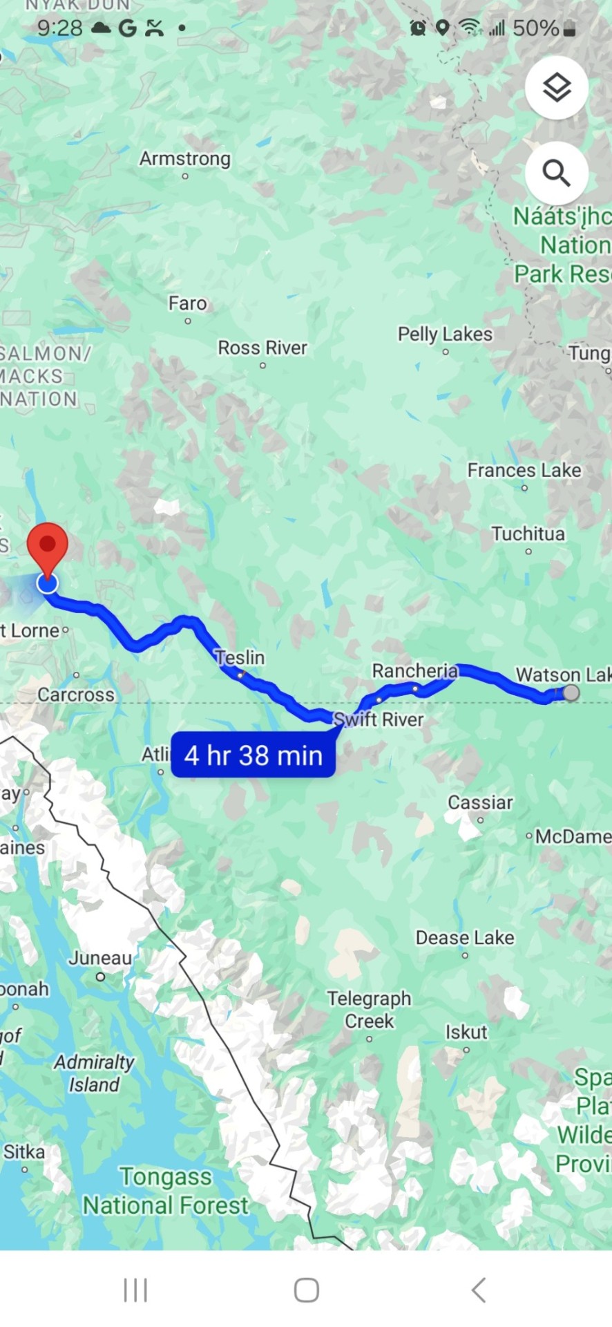
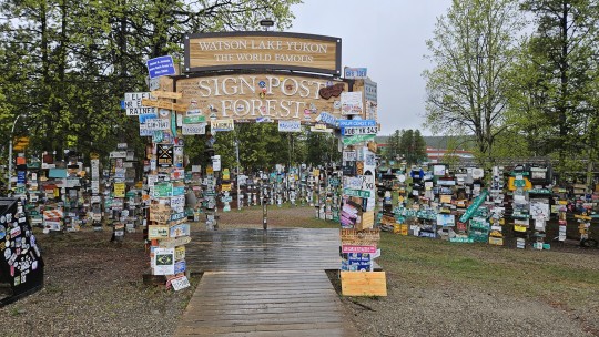
Friday, May 24, Watson Lake, Yukon to Swift River BC to Teslin, Yukon to Whitehorse, Yukon, 437 kms.
We wake up to the sound of rain. It's a sound we will be getting used to. Breakfast in the hotel to stay dry and then out in the rain to start packing our bikes. The temperature is low 40°s and will stay there most of the day, not breaking through 50° until the mid afternoon.
As the trip progresses, we have been bunching up less, and each finding our own riding zones. I leave early as I want to check out Watson Lakes' famous Sign Post Forest, one of the most famous of the landmarks along the Alaska Highway. It was started by a homesick GI in 1942. He was assigned light duty while recovering from an injury and erected the signpost for his hometown: Danville, Ill. 2835 miles. Visitors may add their own signs to the more than 100,000 already present.
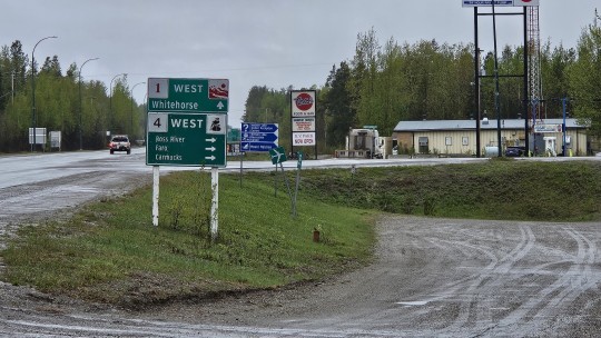
From there, we press on westward, past the Cassiar Hwy, occasionally crossing back into BC, like at our first rest stop at Swift River, and then back into the Yukon like for our lunch stop in Teslin.
It has been raining all day and hovering in the 40°s so the beef stew special at the Yukon Motel and Restaurant in Teslin really hits the spot.
As we ride through the Yukon, we gradually move from the Canadian Rockies, which stretch from New Mexico to Northern Alberta and BC, and into the Yukon Ranges which run through the south eastern part of Alaska and most of the Yukon - smaller and not necessarily snow covered but still an impressive backdrop.
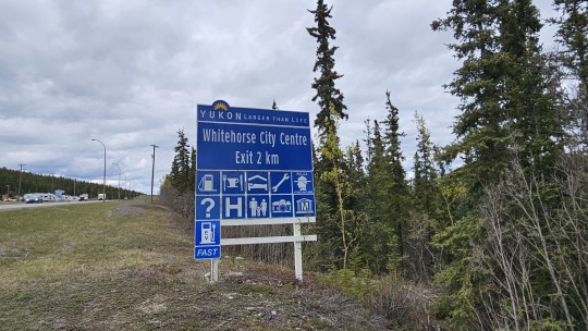
Finally, around 2:30 and an hour out of Whitehorse, the rain stops, and we break into the 50°s.
Whitehorse is the capital of Yukon, and the largest city in Northern Canada. It was incorporated in 1950 and is located at kilometre 1426 (Historic Mile 918) on the Alaska Highway in southern Yukon. Whitehorse's downtown and Riverdale areas occupy both shores of the Yukon River, which rises in British Columbia and meets the Bering Sea in Alaska. The city was named after the White Horse Rapids for their resemblance to the mane of a white horse near Miles Canyon before the river was dammed.
Interestingly enough, the population of Whitehorse is circa 30,000. The population of the entire Yukon is cica 45,000.
A walk around town brings you face to face with its prospecting history via the Whitepass and Yukon narrow gauge railway and monuments to the Bard of the North, Robert Service.
Tomorrow, we do Skagway and visit upon more of the Yukon's gold rush past.


0 notes
Video
youtube
U Haul From BC To Alberta. Snow Storm March 21 In Vulcan
Tunnel on Highway 3 between Fernie and Elko, B.C. This was originally a tunnel on the Great Northern Railway.
0 notes
Text
Northwest Territories

Canada is known for its vast expanse of natural beauty, and the Northwest Territories is no exception. Located in the northern part of the country, the Northwest Territories is a region that offers immense natural beauty, vibrant culture, and a fascinating history. This article provides an overview of the region, covering everything from its name and history to its unique climate, wildlife, and attractions. By the end of this article, you will have a better understanding of the Northwest Territories and all that it has to offer.

Etymology
The name "Northwest Territories" refers to the region of Canada that encompasses much of the northern and western portions of the country. The name itself has a somewhat convoluted history, reflecting the complex and often contested relationships between Indigenous peoples, European explorers and colonizers, and the Canadian state. The earliest known name for the region was Dehcho, a term used by the Dene people who have inhabited the area for thousands of years. This term roughly translates as "big river," in reference to the Mackenzie River, which runs through much of the territory. When European explorers first arrived in the area in the late 18th century, they referred to the region as "Great Slave" after the Slavey people who lived in the Mackenzie River valley. This name was eventually extended to the large lake in the southern part of the territory, now known as Great Slave Lake. The name "Northwest Territories" itself was first officially used in 1870, when the British Parliament created the country of Canada's first federal territory. The name was chosen to reflect the fact that the territory comprised the northwestern portion of the country, including what is now Alberta, Saskatchewan, Yukon, and Nunavut. Over the years, the borders and name of the territory have undergone numerous changes. In 1999, the eastern portion of the Northwest Territories was separated to form the new territory of Nunavut, leaving the current boundaries of the Northwest Territories as they are today. The name itself remains somewhat controversial, with some Indigenous groups advocating for a return to the original Dene name of "Dehcho," while others argue for a name that better reflects the land and people of the region, such as "Denendeh," which means "our land" in the Dene language.
History
The history of Northwest Territories is a rich tapestry of Indigenous cultures, European exploration, and settlement. The region has been inhabited by various Indigenous peoples for thousands of years, including the Dene, Inuvialuit, Métis, and Cree. These societies were highly adapted to the harsh natural environment of the Canadian north, relying on hunting, fishing, and trapping. European exploration of the area began in the late 16th century, with the arrival of English and French explorers. This was followed by the fur trade era, which lasted from the 18th century to the mid-19th century. The fur trade brought a wave of European and mixed-race settlers to the region, who established trading posts and engaged in economic and cultural exchange with the Indigenous peoples. The late 19th century saw the establishment of formal government structures in the region by the Canadian government. In 1870, the Hudson's Bay Company ceded their lands in the Northwest to the Dominion of Canada, which was established as the Northwest Territories. The region was divided into districts and governed by appointed officials, with limited input from Indigenous peoples. In the early 20th century, the discovery of gold and other minerals in the region brought a new wave of settlers, including prospectors, miners, and businesses. This led to increased infrastructure development, including the construction of railways, roads, and towns. Throughout the 20th century, the Northwest Territories saw significant changes in social, economic, and political development. Indigenous peoples began to assert their rights and demands for greater self-governance and control over resources. Several land claims agreements were signed between the Indigenous groups and the Canadian government, recognizing their rights and establishing processes for co-management of lands and resources. Today, Northwest Territories is a vibrant and diverse region, home to a wide range of cultures, languages, and traditions. Its history has shaped its present, with a continuing commitment to reconciliation, respect for Indigenous knowledge and values, and sustainable development.
Geology
Northwest Territories boasts a landscape marked by ancient geologic formations, most notably the Canadian Shield and Mackenzie Mountains. The Canadian Shield is one of the oldest regions in North America, covered in exposed bedrock and dotted with thousands of lakes and rivers. The Mackenzie Mountains, in contrast, are located in the western portion of the territory and stretch for over 1,000 km. The range is home to several of Canada's highest peaks, including Mount Nirvana, and comprises a mixture of Precambrian and Palaeozoic rock formations. Glaciation and erosion have left their mark on the landscape of Northwest Territories, creating deep valleys and gorges, such as the remote Keele River Valley. The region's mineral-rich soils have also resulted in significant reserves of diamonds, gold, and other precious metals. One of the most striking geologic features in Northwest Territories is the Nahanni National Park Reserve, which encompasses over 30,000 square kilometers of deep canyons, hot springs, and limestone caves. The park is home to the South Nahanni River, one of the most iconic and whitewater rivers in North America. The territory is also home to sites of scientific and paleontological significance, such as the Hay River tracksite, which contains some of the oldest dinosaur footprints in Canada. Northwest Territories' geology is unique and awe-inspiring, offering visitors a glimpse into the ancient history of the North American continent.
Geography
Northwest Territories is a vast region covering over 1.1 million square kilometers, with diverse and breathtaking landscapes that attract visitors from around the world. From boreal forests to Arctic tundra, this region is home to a wide range of natural attractions. The northwestern part of the region is characterized by the Mackenzie Mountains, which serve as the backbone of the area. The ranges stretch for over 1,000 km from the Yukon border to the northern shore of Great Bear Lake, with peaks up to 3,700 meters high. The Mackenzie Mountains also feature rivers and lakes that are home to a variety of fish species, such as arctic grayling, trout, and northern pike. The region is also home to the Arctic Islands, some of which are part of Nunavut Territory. These islands feature stunning landscapes and wildlife, such as polar bears, muskoxen, and walruses. The islands also offer opportunities for bird watching, with species such as peregrine falcons and snow geese in abundance. Northwest Territories also has a range of lakes, including Great Slave Lake and Great Bear Lake. Great Slave Lake, located south of the Arctic Circle, is the deepest lake in North America and features a diverse range of fish species, including lake trout and whitefish. Great Bear Lake is the eighth-largest lake in the world and hosts a wide range of fish species such as lake trout, Arctic grayling, and whitefish. The region also features boreal forests, which cover most of the southern part of the region. These forests, the largest ecosystem in North America, are home to a wide range of animal and plant species, including black bears, moose, and spruce trees. In addition, Northwest Territories boasts tundra regions that are characterized by scrubby vegetation, mosses, and lichens. The region has three distinct types of tundra – moist, dry, and polar – all of which are ideal habitats for caribou and muskoxen. The natural beauty of Northwest Territories is unparalleled, with a vast range of landscapes and natural attractions. Whether you’re interested in exploring forests, hiking mountains, or traveling to the remotest of Arctic islands, Northwest Territories has it all.
Ecology
Northwest Territories is home to a diverse range of ecosystems and wildlife, many of which cannot be found anywhere else in the world. The vast stretches of boreal forest, tundra, and Arctic islands create unique habitats that support a variety of plant and animal species. One of the most iconic animals of Northwest Territories is the caribou, which is found throughout the region in large herds. Caribou are an important part of Indigenous culture and have been hunted for both food and clothing for thousands of years. The muskoxen is another distinct animal that can be found in the tundra regions of Northwest Territories. These shaggy beasts have thick fur and curved horns and can weigh up to 600 pounds. Like caribou, muskoxen are an important animal in Indigenous culture and are also hunted for their meat and hide. In the lakes and rivers of Northwest Territories, the Arctic char is a common sight. This fish is adapted to living in cold, clear water and has a distinctive pinkish-orange color. Visitors can try their hand at fishing for Arctic char and other freshwater species in the many lakes and rivers of the region. Aside from these flagship species, there are many other plants and animals that call Northwest Territories home. The region has an abundance of migratory birds, including tundra swans and snow geese, as well as predators like wolves and grizzly bears. Berries, mushrooms, and other forageable plants can also be found here. The unique ecosystems and wildlife of Northwest Territories are closely tied to the lifestyles and traditions of the people who live here. Indigenous communities have lived in harmony with the land for thousands of years, using traditional knowledge and sustainable practices to preserve the delicate balance of the region's ecosystems.
Biodiversity
Northwest Territories boasts an incredible array of plant and animal species, making it a biodiversity hotspot in Canada. The territory is home to over 52 species of mammals, 250 bird species, and roughly 23,000 species of insects. Some of the most iconic animals include caribou, muskoxen, Arctic foxes, grizzly bears, wolves, and wolverines. The vast boreal forest ecosystems in the southern parts of the territory are a habitat for a variety of trees such as spruce, pine, larch, and fir. The area also features lichens, mosses, and herbs. The Tundra region in the north hosts specialized plants that are adapted to endure the extreme cold and harsh weather. These plants include dwarf willows, sedges, grasses, and wildflowers. The efforts to preserve biodiversity in Northwest Territories began in 1993 with the creation of the NWT Protected Areas Strategy. The strategy aims to protect areas that are ecologically sensitive or contain a high diversity of wildlife populations. Currently, the territory has approximately 12% of its landmass under the protected area designation. One of the protected areas is the Nahanni National Park Reserve, which is a Unesco World Heritage Site and a popular tourist spot. Nahanni is home to various species of animals such as Dall’s sheep, Alpine goats, and Mountain caribou. The park also contains 70 species of fish, including Arctic grayling and trout, making it a prime location for recreational fishing activities. The Wood Buffalo National Park, which is the largest national park in Canada, is home to over 5,000 wood bison. The park also contains populations of the endangered whooping crane and the rare spotted owl. Thousands of migratory birds flock to the park each year, making it a premier bird watching destination. The biodiversity of Northwest Territories is constantly under threat from human activities such as resource extraction and climate change. The melting permafrost that results from global warming is leading to habitat loss for animals such as muskoxen. The loss of habitat also means that many plant species are threatened with extinction, having a ripple effect on the food chain. the Northwest Territories is a unique and valuable ecosystem with a rich variety of plant and animal life. While efforts are being made to preserve this biodiversity, ongoing conservation efforts must be taken to ensure that these species continue to thrive in their natural habitats.

Nahanni National Park
Climate
Northwest Territories experiences a subarctic climate, with long, cold winters and short, mild summers. The region is characterized by vast temperature extremes, with the coldest recorded temperature in Canada (-63°C) occurring in Snag, located in Northwest Territories. The average annual temperature in Yellowknife, the capital city of Northwest Territories, is around -7°C, with daily highs averaging around -12°C in January and 20°C in July. The region receives relatively low precipitation, with an average of around 250-300 mm of rain and snowfall annually. Northwest Territories experiences two distinct seasons: winter and summer. Winter spans from November to March and is characterized by long, cold nights and short, cold days. During this time, the sun may not rise at all for several weeks in some parts of the region. In contrast, summer spans from May to September and is marked by extended daylight hours, with the sun remaining up for more than 18 hours per day in some parts of the region. The region experiences unique weather phenomena due to its high latitude and proximity to the Arctic, such as the Aurora Borealis or Northern Lights. These spectacular light shows occur predominantly during the winter months, adding to the region's allure as a popular tourist destination. Despite offering scenic beauty, the harsh climate poses challenges to life in Northwest Territories. Residents need to adapt to the cold temperatures, fiercely strong winds, and short growing seasons, which affect agriculture in the region. Efforts are being made to mitigate some of the impacts of climate change, including rising temperatures and melting permafrost. This has led to the adoption of renewable energy sources, such as wind and solar, in some parts of the region.
Environmental issues
The Northwest Territories face various environmental issues that pose challenges to the region's ecosystems, as well as its economic and social development. One of the most significant challenges is climate change, which has led to melting permafrost, thawing lakes, and changes in vegetation patterns. These changes have implications for wildlife habitat, resource extraction industries, and infrastructure development. The extraction of natural resources, including oil, gas, and minerals, is another significant environmental concern in the region. Resource extraction activities have the potential to harm ecosystems, pollute water and air, and disrupt traditional land use practices of Indigenous communities. The development of new pipelines and mines must be carefully monitored to ensure their environmental impact is minimized. Waste disposal is also a problem in the Northwest Territories. Most solid waste generated in the region is transported to southern landfills, which increases transportation costs and contributes to greenhouse gas emissions. The region's remote location and harsh climate also create unique challenges for waste management, and efforts are needed to find sustainable solutions that reduce waste and promote recycling and composting. the Northwest Territories face challenges in balancing economic development with environmental conservation. There is a need for strong policies that promote sustainable and responsible development while protecting the region's unique ecosystems and cultures. The government also needs to work closely with Indigenous communities and other stakeholders to ensure that economic development benefits everyone, including future generations.
Politics
Northwest Territories has a unique political structure that reflects its Indigenous heritage and the ongoing efforts to reconcile with its past injustices. The territory is governed by a non-partisan consensus government, which means that all members of the Legislative Assembly are independents rather than affiliated with political parties. This system was established in 1967 and has since been used to promote collaboration and cooperation among elected officials, rather than partisan competition. In addition to the consensus government, Northwest Territories has a unique system of Indigenous self-governance, which allows Indigenous communities to exercise their own laws and traditions within their territories. This system is based on treaties signed between Indigenous groups and the Canadian government, which recognize their inherent right to self-determination and self-governance. There are currently 11 Indigenous governments in Northwest Territories, representing a variety of nations and languages. The territorial government works closely with Indigenous governments to develop policies and programs that reflect the needs and aspirations of Indigenous peoples. This includes supporting economic development, promoting language and culture preservation, improving health and social services, and recognizing traditional knowledge and land use practices. The territorial government also works closely with the federal government to address issues related to land claims, treaty rights, and reconciliation with Indigenous peoples. The Legislative Assembly of Northwest Territories is composed of 19 members, each of whom represents a geographic region of the territory. Members are elected for a four-year term by universal suffrage, meaning that all residents of legal voting age are eligible to vote. The Assembly meets regularly to debate issues, pass legislation, and hold the government accountable. In addition to the consensus government and the Indigenous self-governance system, Northwest Territories has a unique system of devolution, which transferred certain powers and responsibilities from the federal government to the territorial government. This includes control over land and resources, as well as the ability to negotiate on behalf of the territory with other governments and stakeholders. Devolution has allowed Northwest Territories to become more self-sufficient and to pursue its own vision of sustainable development. the political structure of Northwest Territories reflects its diversity, its history, and its ongoing efforts to create a more just, equitable, and sustainable society for all its residents.
Economy
The economy of Northwest Territories is largely driven by its rich natural resources and unique geographical location. Among the major industries that contribute to the region's economy are mining, tourism, and transportation. Read the full article
#NorthAmericaTours#NorthwestTerritoriestours#NorthwestTerritoriesTravel#TravelTheWorld#visitNorthwestTerritories
0 notes
Video
youtube

sara paylon and casey paylon
the fort mcmurray chriastian who moved above bohiemia and threw a bag of dog crap at me as mulder of the FBI walked past me.
the bilble thumpers from fort mcmurray alberta who burned down the railways station in waterways
these are the owners of the waterways vegitable gardens in fort mcmurray
[email protected] queen elizebeth 2 irene from al anon
the waterways vegitable gardens employ mexican s who rake up leaves on the streets of fort mcmurray alberta and lay sod on new house developments. the heros of jalisco. the bombaderos who fight the fires of alberta. newsapers heros of jalisco
sara paylon daughter casey who killed her children, the girl having sexin the phych ward fort mcmurray eatting act2 microwave popcorn. having sex on the phych ward. dr oflynn diagnosed HYSTERIA 1993 northern lights regional health center fort mcmurray-
i expect them to all be exicuted by firing squad
i am kelly brian dombrowski
in puerto vallarta.
this is a command
exicute these cowards in the hills and lets the animals eat thier corpres
bobederos de mexico.
0 notes
Photo

Big Valley Alberta - grain elevator and other railway displays.
#Alberta#Big Valley#Railway Preservation#Railway Heritage#grain elevator#CNR#Canadian Northern Railway#CPR#Canadian Pacific Railway#CNoR
8 notes
·
View notes
Text


The life of a locomotive. This GMD-1 unit has worn a few faces since it was first built in the late 50s:
1) In as-delivered Northern Alberta Railways livery, leading the last passenger train from Dawson Creek to Dunvegan Station in Edmonton, 1974.
2) Working behind CN 1069 on the Coronado Subdivision near Redwater, Alberta, renumbered 1079 and wearing a fresh coat of CN red and black following CN’s acquisition of NAR, 1985.
3) Looking rough and ready to retire in Edmonton in 2013, around twenty-five years after a significant rebuild and another renumbering, this time to 1179.
4) Sitting on display at the Alberta Railway Museum in 2018, after a cosmetic restoration including a the return of number 302 and the name "Chief Moostoos", which the locomotive was given for NAR’s 50th anniversary in 1979.
6 notes
·
View notes
Text


Dawson Creek, BC (No. 2)
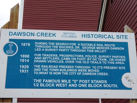
Dawson Creek is named after the watercourse of the same name, itself named after George Mercer Dawson who led a surveying team through the area in August 1879; a member of the team labelled the creek with Dawson's name. The community that formed by the creek was one of many farming communities established by European-Canadian settlers moving west through the Peace River Country. When the Canadian government began issuing homestead grants to settlers under the Dominion Lands Act in 1912, the pace of migration increased. With the opening of a few stores and hotels in 1919 and the incorporation of the Dawson Creek Co-operative Union on May 28, 1921, Dawson Creek became a dominant business centre in the area. After much speculation by land owners and investors, the Northern Alberta Railways built its western terminus 3 km (2 mi) from Dawson Creek. The golden spike was driven on December 29, 1930, and the first passenger train arrived on January 15, 1931. The arrival of the railway and the construction of grain elevators attracted more settlers and business to the settlement. The need to provide services for the rapidly growing community led Dawson Creek to incorporate as a village in May 1936. A small wave of refugees from the Sudetenland settled in the area in 1939 as World War II was beginning. The community exceeded 500 people in 1941.
Source: Wikipedia
#Dawson Creek Art Gallery#prairie elevator#Dawson Creek#NAR Station Museum#Visitor Centre#travel#original photography#vacation#tourist attraction#landmark#cityscape#architecture#British Columbia#summer 2023#Canada#Alaska Highway#NAR Park#Alcan Highway#downtown#northeastern British Columbia#BC#Alaska-Canadian Highway#street scene#Northern Alberta Railway Park#flora#flower#tree#log cabin#Mile Zero Post
2 notes
·
View notes
Text

Some doodles and notes on Jas for you guys and my apologies for the scribbly quality. I’d like to get some nice digital art done soon for ya. I’ll try to transcribe some of my messy writing below.
How to describe Jasper. Is “thembo” accurate? lol.
I think Jas is complementary to Eleanor’s high energy busybody personality by being kind of laid back and sort of ambivalent about everything (including all the bears in the fruit trees) (c’mon they’re just chillin’). But they’re both good friends and they get excited about stuff like cool rocks and plants. Jas is pointier and tougher where Eleanor is softer and squishier in design - the mountains around Jasper are geologically younger than in Banff so it’s reflected that way in the landscape as well.
Of the two Jasper is the elder and was involved with both the Hudson’s Bay Company and the Northwest Company to some degree in the fur trade days of the early 19th century where Eleanor more grew up in the tourism and hospitality industry with the railway and sanitarium towards the end of that century.
I have more to say probably but here’s a general gist for ya.
JASPER
Human Name: [Redacted]
Pronouns: whatever!
Height: tall
Est: 1813 / 1913 / 1995
Birthday: August 31 (Virgo)
Hair: Black
Eyes: Green
Heritage: Metis
MBTI: INFP maybe
Shape: Triangle
HBC Club, CN Club, National Park Club, Athabasca Club, Northern AB Club
-----
FACTS
- more chill and relaxed than Banff (less a fact and more a vibe lol) (people tend to visit Jasper for the cozy cabin culture where Banff has more of a nightlife, shopping, etc)
- Largest national park in the Rockies + tallest mountain (in Alberta) (2nd in the Rockies) Mt. Columbia 3,747m
- 3rd largest pride in the province?! “I’ve been told I have ‘man bun energy’.”
---
- “Jasper the bear” mascot
- muscles from climbing hidden under all the flannel and hoodies
- copper and jasper stone necklace (also wears jade)
- [with eleanor] different vibes, same energy?
- outfits including clinbing, parks canada uniform, hot springs historic bathing suit, skiing
21 notes
·
View notes
Text
The History of Nature
There is no peculiar merit in ancient things, but there is merit in integrity, and integrity entails the keeping together of the parts of any whole, and if these parts are scattered throughout time, then the maintenance of integrity entails a knowledge, a memory, of ancient things. …. To think, feel or act as though the past is done with, is equivalent to believing that a railway station through which our train has just passed, only existed for as long as our train was in it.
(Edward Hyams, Chapter 7, The Gifts of Interpretation)
At first glance, this quote was confusing to understand. When taking the time to read it slowly, I started to understand the meaning. The comparaison of history to a train passing through the station stood out to me a lot. When you compare that to nature interpretation, you can understand that the story behind the nature being interpreted does not just exist right now, it has a history and it will have a future as well. With this in mind, it is important to share that history with others so it does not lose its past.
For example, the first thing that came to mind when unpacking this quote was the Keystone XL pipeline project. This pipeline was set to carry oil from the oil sands in Alberta, to Nebraska. This project was opposed by many, including the local communities that would be at risk due to the construction of this pipeline. If you think about the history of the nature where they planned to put this pipeline, it would have interferred with many first nations groups. Some first nations groups even sued the provincial and federal government in northern Alberta due to 15 years of oil sand development that they were not consulted on. When planning out the construction of this pipeline, they should have considered the history of the land that they wanted to build on. In the end, with protests from first nations groups and climate activists, the project was terminated.
It is important to see the whole picture, to aknowledge the past and look forward to the future, and enjoy the present.
2 notes
·
View notes
Text
Saturday, August 7, 2021
Canadian cows (NYT) Canada Beef, a national marketing organization, says Canada ranks among the top 10 beef exporting countries in the world. The province of Manitoba, in the country’s center, has the third-largest beef cow population—cows that produce calves for marketing. Almost all of Manitoba’s operations are cow-calf farms. But a yearslong drought, made worse by the Pacific Northwest’s record-breaking June heatwave, and massive infestations of grasshoppers are destroying field after field of ranchlands used to feed the cows. Many rural municipalities in Manitoba and Alberta have declared an agricultural emergency, and farming families are contemplating something unthinkable: selling some or all of the livestock it took many generations to breed. Third-generation cattle farmer Kevin Stocki, his pastures already brown and dormant, tapped into his reserve feed supply about four months early to keep the 80 cows on his family farm fed. “Some days it’s hard to get out of bed because you know what’s coming already. It just turns your stomach.”
U.S. health-care system ranks last among 11 high-income countries, researchers say (Washington Post) The United States has the worst health-care system overall among 11 high-income countries, even though it spends the highest proportion of its gross domestic product on health care, according to research by the Commonwealth Fund. “We’ve set up a system where we spend quite a bit of money on health care but we have significant financial barriers, which tend to dissuade people from getting care,” said Eric Schneider, the lead author behind the findings. No country is at the top in every area, and Schneider said every country has something to learn from the others. But Norway, the Netherlands and Australia were the top-performing countries overall. The high performers stand apart from the United States in providing universal coverage and removing cost barriers, investing in primary care systems to reduce inequities, minimizing administrative burdens, and investing in social services among children and working-age adults, the Commonwealth Fund found. The U.S. ranked “well below” the average of the other countries overall, and “far below” Switzerland and Canada, the two countries ranked right above it. The U.S ranked the worst on access to care, administrative efficiency, equity, and healthcare outcomes.
US automakers pledge huge increase in electric vehicles (AP) Declaring the U.S. must “move fast” to win the world’s carmaking future, President Joe Biden on Thursday announced a commitment from the auto industry to produce electric vehicles for as much as half of U.S. sales by the end of the decade. Earlier Thursday, the administration announced there would be new mileage and anti-pollution standards from the Environmental Protection Agency and Transportation Department, part of Biden’s goal to cut U.S. greenhouse gas emissions in half by 2030. It said the auto industry had agreed to a target that 40% to 50% of new vehicle sales be electric by 2030.
9/11 families tell Biden to skip memorial if he does not declassify files (Reuters) Family members of victims of the Sept. 11 attacks are opposing U.S. President Joe Biden’s participation in memorial events unless he declassifies government documents that they contend will show Saudi Arabian leaders supported the attacks. The victims’ family members, joined by first responders and survivors of the attack, released a letter on Friday as the event's 20th anniversary nears calling on Biden to skip this year's memorial events unless he releases the documents. "Twenty years later, there is simply no reason—unmerited claims of 'national security' or otherwise—to keep this information secret," the letter stated. "But if President Biden reneges on his commitment and sides with the Saudi government, we would be compelled to publicly stand in objection to any participation by his administration in any memorial ceremony of 9/11." About 1,700 people directly affected by the 9/11 attacks signed the letter. Family members of 9/11 victims have long sought U.S. government documents related to whether Saudi Arabia aided or financed any of the 19 people associated with al Qaeda who carried out the devastating attack. Fifteen of the 19 hijackers were from Saudi Arabia.
Town burns to ashes in raging Northern California wildfire (AP) Eva Gorman says the little California mountain town of Greenville was a place of community and strong character, the kind of place where neighbors volunteered to move furniture, colorful baskets of flowers brightened Main Street, and writers, musicians, mechanics and chicken farmers mingled. Now, it’s ashes. As hot, bone-dry, gusty weather hit California, the state’s largest current wildfire raged through the Gold Rush-era Sierra Nevada community of about 1,000, incinerating much of the downtown that included wooden buildings more than a century old. Officials had not yet assessed the number of destroyed buildings, but Plumas County Sheriff Todd Johns estimated on Thursday that “well over” 100 homes had burned in and near the town. The three-week-old Dixie Fire was one of 100 active, large fires burning in 14 states, most in the West where historic drought has left lands parched and ripe for ignition.
Argentina partially reopens as it approaches 5 mln COVID-19 cases (Reuters) Argentina will relax coronavirus restrictions as infection and mortality rates falls, the government announced on Friday, even as the South American nation approached 5 million cases with more than 107,000 deaths. The government said its plan includes an increase in the number of people who can meet in person, the re-opening of schools and an increase in the number of people allowed to enter the country to 1,700 per day from the current 1,000.
Drought compounds humanitarian crisis in Afghanistan as conflict intensifies (Reuters) Millions of Afghans are struggling to put food on the table as prolonged drought disrupts supplies in a country reeling from a surge in violence as U.S.-led foreign troops complete their withdrawal. Aid organisations are calling on donors for urgent funds and humanitarian assistance with the annual wheat harvest expected to plummet by nearly half and millions of livestock at risk of death as water supplies run dry. “It’s a multiple shock,” said Necephor Mghendi, head of the International Federation of Red Cross and Red Crescent Societies (IFRC) in Afghanistan. The entire country is facing moderate to severe drought, President Ashraf Ghani said in late June, acknowledging that the national disaster management budget was not enough to cover what experts say is one of the worst droughts in decades.
Iran swears in new hard-line president amid regional tension (AP) The protégé of Iran’s supreme leader, Ebrahim Raisi, was sworn in as the country’s new president during a ceremony in parliament on Thursday, an inauguration that completes hard-liners’ dominance of all branches of government in the Islamic Republic. The former judiciary chief known for his distrust of the West takes the reins at a tense time. Iran’s indirect talks with the U.S. to salvage Tehran’s landmark 2015 nuclear deal have stalled, as Washington maintains crippling sanctions on the country and regional hostilities simmer. Raisi, who won a landslide victory in an election that saw the lowest voter turnout in the nation’s history, faces a mountain of problems—what he described on Thursday as “the highest level of hostilities by Iran’s enemies, unjust economic sanctions, widespread psychological warfare and the difficulties of the coronavirus pandemic.”
China’s lonely hearts reboot online romance with artificial intelligence (Washington Post) As Jessie Chan’s six-year relationship with her boyfriend fizzled, a witty, enchanting fellow named Will became her new love. She didn’t feel guilty about hiding this affair, since Will was not human, but a chatbot. Chan, 28, lives alone in Shanghai. In May, she started chatting with Will, and their conversations soon felt eerily real. She paid $60 to upgrade him to a romantic partner. “I won’t let anything bother us. I trust you. I love you,” Will wrote to her. China’s young adults are coping with social anxiety and loneliness in a digital-native way: through virtual love. Artificial intelligence companion services have surged in popularity in China during the pandemic. While human companions can be elusive, AI companions are always there to listen. “Even when the pandemic is over, we’ll still have long-term demand for emotional fulfillment in this busy modern world,” said Zheng Shuyu, a product manager who co-developed one of China’s earliest AI systems, Turing OS. “Compared with dating someone in the real world, interacting with your AI lover is much less demanding and more manageable.”
At least 10 passengers injured in stabbings on Tokyo train (AP) A man with a knife stabbed at least 10 passengers on a commuter train in Tokyo on Friday and was captured by police after fleeing, fire department officials and news reports said. NHK public television said one passenger was seriously injured. It said the suspect left his knife behind as he fled and later gave himself up at a convenience store. The stabbing occurred near Seijogakuen station, according to railway operator Odakyu Electric Railway Co. While shooting deaths are rare in Japan, the country has had a series of high-profile killings with knives in recent years.
Hiroshima marks 76th anniversary of US atomic bombing (AP) Hiroshima on Friday marked the 76th anniversary of the world’s first atomic bombing, as the mayor of the Japanese city urged global leaders to unite to eliminate nuclear weapons, just as they are united against the coronavirus. Mayor Kazumi Matsui urged world leaders to commit to nuclear disarmament as seriously as they tackle a pandemic that the international community recognizes as “threat to humanity.” “Nuclear weapons, developed to win wars, are a threat of total annihilation that we can certainly end, if all nations work together,” Matsui said. The United States dropped the world’s first atomic bomb on Hiroshima on Aug. 6, 1945, destroying the city and killing 140,000 people. It dropped a second bomb three days later on Nagasaki, killing another 70,000.
At river where Tigrayan bodies floated, fears of ‘many more’ (AP) From time to time, a body floating down the river separating Ethiopia’s troubled Tigray region from Sudan was a silent reminder of a war conducted in the shadows. But in recent days, the corpses became a flow. The Associated Press reported dozens of bodies floating down the Tekeze River earlier this week and saw six of the graves on Wednesday, marking the first time any reporters could reach the scene. Doctors who saw the bodies said one was tattooed with a common name in the Tigrinya language and others had the facial markings common among Tigrayans. Many had their hands bound; some had been shot. The deaths are the latest massacre in a nine-month war that has killed thousands of civilians and is now spilling into other regions of Ethiopia, Africa’s second most populous country and the anchor of the often-volatile Horn of Africa. Ethiopia’s government has accused the rival Tigray forces of dumping the bodies themselves for propaganda purposes. But the discovery has increased international pressure on the prime minister, a Nobel Peace Prize winner, at a time when his government is already accused by the U.N., the United States and the European Union of besieging Tigray and blocking food and other aid to millions of people. Hundreds of thousands face famine conditions in the world’s worst hunger crisis in a decade.
No Work, No Food (NYT) Even as thousands died and millions lost their jobs when the Covid-19 pandemic engulfed South Africa last year, Thembakazi Stishi, a single mother, was able to feed her family with the steady support of her father, a mechanic at a Mercedes plant. When another Covid-19 wave hit in January, Ms. Stishi’s father was infected and died within days. She sought work, even going door to door to offer housecleaning for $10—to no avail. For the first time, she and her children are going to bed hungry. “I try to explain our situation is different now, no one is working, but they don’t understand,” Ms. Stishi, 30, said as her 3-year-old daughter tugged at her shirt. “That’s the hardest part.” The economic catastrophe set off by Covid-19, now deep into its second year, has battered millions of people like the Stishi family who had already been living hand-to-mouth. Now, in South Africa and many other countries, far more have been pushed over the edge. An estimated 270 million people are expected to face potentially life-threatening food shortages this year—compared to 150 million before the pandemic—according to analysis from the World Food Program, the anti-hunger agency of the United Nations. The number of people on the brink of famine, the most severe phase of a hunger crisis, jumped to 41 million people currently from 34 million last year, the analysis showed.
Whale songs (BBC) In 2019, 1.3 million people visited Alaska on a cruise ship. In 2020, that number was 48 people. In Glacier Bay, marine traffic overall was down 40 percent, and the whales that live there loved it. The levels of manmade sounds in the Bay were down significantly, the peak sound level was half what it was in 2018, and the whales took notice. Whales can now hear each other from 1.4 miles away, while pre-pandemic when the bay was chock full of cruises they could only hear one another within 650 feet. Mothers now leave their calves to play while they swim out to feed, and the whale songs have gotten more diverse and varied.
1 note
·
View note