#multibeam echosounder survey
Explore tagged Tumblr posts
Visit Tumblr Blog
Explore Tumblr blogs with no restrictions, modern design and the best experience.
Last Seen Tumblr Blogs


Fun Fact
Mobile Tumblr US users spend an average of 4.04 minutes per session on the app.
Text
Indian Naval Ship INS Sandhayak Commissioned in Visakhapatnam with State-of-the-Art Sonar Systems
In a significant stride for India's maritime strength, the Indian Navy has proudly commissioned the advanced survey vessel INS Sandhayak in a grand ceremony in Visakhapatnam. Three more will follow. The vessel is equipped with sophisticated sonar systems from Teledyne Marine and represents the pinnacle of modern naval engineering. The Defense Minister, Rajnath Singh, officiated at the commissioning ceremony on Saturday, February 3, 2024. The INS Sandhayak, a 110-meter-long ship with a displacement of 3,400 tons, is powered by two diesel engines and can exceed speeds of 18 knots. Built by Garden Reach Shipbuilders & Engineers (GRSE), the vessel is the first to join the Indian Navy's fleet as part of this program. The commissioning event was graced by VIP guests from the Navy and the Indian Naval Hydrographic Office (NHO), including top-ranked Navy officers from the regional command. The current Chief Hydrographer of India, Vice Admiral Lochan Singh Pathania, and his predecessors were also in attendance to witness this milestone in Indian naval history. Teledyne Marine, a global leader in underwater technology, has been instrumental in providing a suite of advanced sonar systems. These include 4 HydroSweep DS Deep Water Multibeam Echosounders (MBES), 8 SeaBat T-Series Shallow Water Multibeam Echosounders (MBES), and 36 DESO 5 Single Beam Echosounders (SBES).
In a significant stride for India’s maritime strength, the Indian Navy has proudly commissioned the advanced survey vessel INS Sandhayak in a grand ceremony in Visakhapatnam. Three more will follow. The vessel is equipped with sophisticated sonar systems from Teledyne Marine and represents the pinnacle of modern naval engineering. The Defense Minister, Rajnath Singh, officiated at the…

View On WordPress
0 notes
Text
Let’s talk about living shipwrecks!
Do you often wonder what lies on the ocean floor? Or where fish and other sea life live?

In a collaborative research project between the National Centers for Coastal Ocean Science and Monitor National Marine Sanctuary, scientists have worked to answer these questions and more using cutting edge technology to explore under the ocean’s surface. With our nation’s long tradition of honoring and protecting special places that have defined our history, this research serves to commemorate and honor the service members who fought and died off the North Carolina coast in defense of freedom.

Off the North Carolina coast lie scores of ships that sank during the Civil War, World War I, and World War II. Since 2008, Monitor National Marine Sanctuary and partners have studied and documented these historically significant shipwrecks that serve as quiet witnesses to the valor and sacrifices of generations past.

During World War II, the area off Cape Hatteras, North Carolina, emerged as a strategic hotspot for German U-boat activity (see GIF below).
This activity resulted in a collection of shipwrecks unparalleled in the United States consisting of 78 merchant ships, eight Allied warships, and four German U-boats.These shipwrecks serve as gravesites for nearly 1,700 individuals and as a memorial to this history, particularly to the sacrifice of the U.S. Merchant Marine.


Today, these shipwrecks not only represent our nation’s rich maritime history, but they serve as artificial habitat for a diversity of marine life and important fish species!
Pictured below, researchers with the National Centers for Coastal Ocean Science work to document how and when fish use these artificial structures. Understanding how fish communities use these habitats can help researchers ensure that the reef ecosystems remain sustainable in support of the blue economy.

To better understand how these shipwrecks function as artificial habitats, scientists collect data using visual and acoustic methods, including high-resolution seafloor habitat mapping and surveys using echosounders (split beam and multibeam), remotely operated vehicles, time-lapse video, and scientific diving.

Pictured above is a high resolution image of U-352, a German U-boat, and the fish living on it. Individual fish are displayed as orange circles and are detected by an instrument called a split beam echosounder. Pretty cool right?
Want to learn more? Read the full story here: https://sanctuaries.noaa.gov/news/nov20/living-shipwrecks.html
#Shipwrecks#LivingShipwrecks3D#Wrecks#WWII#VeteransDay#Veterans#Maritime#History#MarineLife#MaritimeHistory#Research#Science#U-Boats#ROV#NCCOS#Technology#Mapping
142 notes
·
View notes
Text
Antarctica: Southern Ocean floor mapped in greatest ever detail
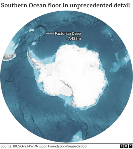
Scientists have made the most precise map yet of the mountains, canyons and plains that make up the floor of Antarctica's encircling Southern Ocean.
Covering 48 million sq km (18.5 million sq miles), this chart for the first time details a new deepest point - a depression lying 7,432m (24,383ft) down called the Factorian Deep.
Knowledge of the shape of the ocean's bottom is essential to safe navigation, marine conservation, and understanding Earth's climate and geological history.
But we still have much to learn.
Vast tracts of terrain have never been properly surveyed.
The International Bathymetric Chart of the Southern Ocean (IBCSO) has taken five years to compile and updates the first attempt at a comprehensive map, which was published in 2013.
The IBCSO project and others like it around the world are gradually filling in the gaps in our scant knowledge of the bottom of the world's oceans.
Ships and boats are being encouraged to routinely turn on their sonar devices to get depth (bathymetric) measurements; and governments, corporations, and institutions are being urged not to hide away data and put as much as possible into the public domain. This is paying dividends.
The new map covers all the Southern Ocean floor poleward of 50 degrees South. If you divide its 48 million sq km into 500m grid squares, 23% of these cells now have at least one modern depth measurement.
That's a big improvement on nine years ago.
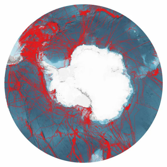
Back then, IBCSO began only at 60 degrees South, and less than 17% of its grid boxes had a modern measurement.
"You have to realise just what the change from 60 degrees to 50 degrees means; we've more than doubled the area of the chart," said Dr Boris Dorschel from Germany's Alfred Wegener Institute.
"So, we've increased the area coverage, but we've also increased the data density, because, in parallel, we've kept on acquiring new data and knocking on doors to free up existing data," he told BBC News.
Much of the information in the chart comes from the ice-strengthened ships that support scientific endeavours in Antarctica, including from the UK's former polar ship, the RRS James Clark Ross. (In future, this British contribution will come from its successor, the RRS Sir David Attenborough, affectionately known as Boaty McBoatface.)
As these vessels shuttle back and forth between the White Continent and the likes of Chile, South Africa and Tasmania - their echosounders make a habit of surveying the submerged terrain below.
And this activity is increasingly coordinated, with research organisations from different nations working together to try to offset slightly the routes taken by their icebreakers.
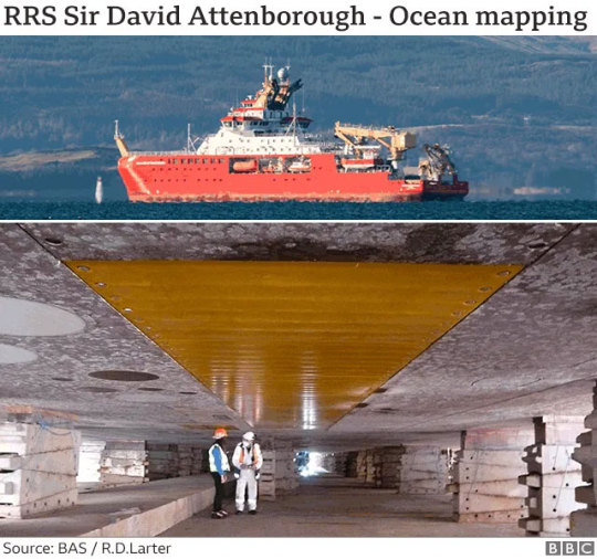
The UK's new polar ship, the RRS Sir David Attenborough, is equipped to map millions of sq km of ocean bottom over its career. The above image shows the ship's hull in dry dock. The yellow rectangle in the centre is a cover made of a synthetic material over the 8m-long array of transmitting transducers for the deep-water multibeam echosounding system.
Better seafloor maps are needed for a host of reasons.
They are essential for safe navigation, obviously, but also for fisheries management and conservation, because it is around the underwater mountains that marine wildlife tends to congregate. Each seamount is a biodiversity hotspot.
In addition, the rugged seafloor influences the behaviour of ocean currents and the vertical mixing of water. This is information required to improve the models that forecast future climate change - because it is the oceans that play a pivotal role in moving heat around the planet.
"We can also study how the Antarctic Ice Sheet has changed over thousands of years just by looking at the seafloor," explained Dr Rob Larter from the British Antarctic Survey.
"There's a record of where the ice flowed and where its grounded zones (places in contact with the seafloor) extended. This is beautifully preserved in the shape of the seafloor."
The new map was made possible by financing from Japan's Nippon Foundation and the support from Seabed2030, the international effort to properly chart Earth's ocean floor by the end of the decade.
Visit shopping bag printing homepage for more details.
At the moment, our knowledge of four-fifths of the planet's underwater terrain comes only from low-resolution satellite measurements that have inferred the presence of tall seamounts and deep valleys from the gravitational influence these features have on the sea surface. Water piles up over the mass of a large submarine mountain and dips slightly where there is a trench.
One key finding in the years between the first and second versions of IBCSO is the recognition of the Southern Ocean's deepest point. It's a depression called Factorian Deep at the far southern end of the South Sandwich Trench. It lies 7,432m down. It was measured and visited by the Texan adventurer Victor Vescovo in his submarine Limiting Factor in 2019.
The remote and often inhospitable nature of the Southern Ocean means substantial sections of it are unlikely to get mapped unless there is dedicated undertaking. There's high hope that an emerging class of robotic vessels could be given this task in the years ahead.
1 note
·
View note
Text
INS Sutlej, the sixth of Sandhayak class survey ship, was commissioned into the #IndianNavy on 19 February 1993 by the then Governor of Sikkim, Admiral RH Tahiliani. The name ‘Sutlej’ has a Vedic origin coined from the word ‘Satadru’ meaning confluence of a hundred rivers. The ship’s compliment comprises 19 officers and 180 sailors who relentlessly exhibit professionalism and ensure commitment to every task in keeping with ship’s motto ‘Excellence is a Tradition’. The primary role of the ship is hydrographic survey for which it is fitted with advanced Hydrographic Survey equipment like #Multibeam #Echosounder, Conductivity temperature depth probe, Side scan #sonar, single beam echo sounder and four survey motor boats fitted with state-of-the-art survey equipment. Some of the landmark survey operations undertaken by the ship include Survey at Oman, Indonesia, Galle Harbour (Sri Lanka) post Tsunami, Makaoni Harbour (Tanzania), Colombo Harbour (Sri Lanka) and Indo Myanmar Joint Hydrographic Survey off Myeik. The ship holds the distinction of being awarded Unit Citation twice in the year 2005 and 2014. The ship has also won Best Survey Ship award (Admiral Jal Cursetji Trophy) five times in the years 1995, 2009, 2010, 2016 and 2019. #ltcdrpravinsuryaask
https://www.instagram.com/tv/CaJmMP2I6PV/?utm_medium=share_sheet
0 notes
Text
Seabed 2030 Project and Kongsberg Maritime Partner on Seabed Map
[By: Kongsberg Maritime]
The Nippon Foundation-GEBCO Seabed 2030 Project and Kongsberg Maritime have entered a Memorandum of Understanding in support of the global initiative to produce the complete map of the ocean floor. Under the terms of the MOU, the two parties will work together to advance understanding of ocean bathymetry. The effort complements the goals of the United Nations Decade of Ocean Science for Sustainable Development.
Seabed 2030 is a collaborative project between The Nippon Foundation and GEBCO to inspire the complete mapping of the world's ocean by 2030, and to compile all bathymetric data into the freely available GEBCO Ocean Map. GEBCO is a joint project of the International Hydrographic Organization (IHO) and the Intergovernmental Oceanographic Commission (IOC), and is the only organisation with a mandate to map the entire ocean floor.
Kongsberg Maritime provides solutions for safe, efficient and sustainable maritime operations. The solutions are suitable for offshore energies, seaborne transportation, hydrography, science, navy, coastal marine, aquaculture, training services and more. Kongsberg Maritime is the largest business area within Kongsberg Gruppen ASA. The Group has an integrated portfolio of solutions for businesses, partners and nations operating from the depths of the sea to outer space and to the digital frontier.
“Seabed 2030 greatly welcomes the support of Kongsberg Maritime,” commented Jamie McMichael-Phillips, Director of the Seabed 2030 Project. “KONGSBERG’s prominent capabilities in providing sustainable maritime operations closely align with our ethos and aim here at Seabed 2030.”
Bjørn Jalving, Senior Vice President Technology, Kongsberg Maritime said: “As an organisation committed to offering the best marine technology, we are delighted to support Seabed 2030 in its mission of producing the definitive map of the seafloor.
“We envisage our systems for surveying, positioning and navigation to contribute rewardingly to this imperative global effort. We will specifically develop freely available functions for Kongsberg Maritime multibeam echo sounders, single beam echosounders and AUVs that ease the process of contributing bathymetric data to the Seabed 2030 data centres. The development will be collaboratively with the University of New Hampshire and Stockholm University.
“A complete map of the seafloor is a critical first step in understanding our planet through ocean exploration. We’re proud to support the Seabed 2030 Project.”
All data collected and shared with the Seabed 2030 Project is included in the GEBCO global grid, which is free and publicly available.
from Storage Containers https://maritime-executive.com/article/seabed-2030-project-and-kongsberg-maritime-partner-on-seabed-map via http://www.rssmix.com/
0 notes
Text
[0822-1515-2011] Survey Pemetaan dan Jenis-jenis Pekerjaannya.
Profesi penyedia Jasa sebagai konsultan pemetaan, perusahaan pemetaan di Nusantara ini sangat beragam, berbagai berkomitmen perusahaan memberikan layanan terbaik jaminan serta kualitas terbaik.

Jenis Perusahaan Pemetaan, sebagai Konsultan ini, dapat di klasifikasikan seperti Jasa survey topografi, konsultan Topografi, dan Jasa Topografi untuk pengukuran di darat.
Biasa di sebut topographic survey company, Land Survey, Jasa survey Pemetaan. topography company bertugas melaksanakan pekerjaan pengukuran tanah atau subbidang survey permukaan tanah, survey permukaan bawah tanah, dan survey teknik sipil.
pengukuran tanah atau jasa ukur tanah sebagai surveyor di Indonesia banyak ditemukan Website Jasa Survey Topografi. Pengukuran tanah di Bandung Dan Jakarta contohnya. Kedua kota ini sangat strategis dalam pencariaan konsultan survey.
SURVEY DARAT di kategorikan beberapa Jenis:

geodetik survey
Survey GPS Survei GODETIK GNSS, metode RTK/PPK, Real time kinematics.
survey ini di indonesia menyediakan Pemasangan Titik Referensi Permanen / Non Permanen sistem proyeksi terhadap datum Global WGS84, elipsoid dan lokal datum
melalui pengamatan jaring kontrol dibuat titik referensi baku dengan koreksi tingkat tinggi yang dinamakan survey Geodetik.
survey geodetik memiliki Tingkat ketepatan posisi dan ketinggian yang dicapai dalam survei ini kurang dari sentimeter, dapat sebagai referensi untuk pengembangan Lahan, perluasan, serta tahap awal perencanaan Konstruksi serta Kebutuhan Industri.
Survey Konstruksi
Jasa survey ini melaksanakan pengawasan dengan tingkat akurasi sesuai standar yang berlaku, dapat mendukung dalam proses pembangunan dalam implementasi perencanaan seperti:
• Pencarian titik atau stake out
• Setting tata letak bangunan
• Monitoring Struktur bangunan
• kelurusan ketinggian konstruksi bangunan
• Struktur bangunan dan Pabrik yang kompleks
• pelaksanaan desain konstruksi baja sebagai survey engineering.
• Penentuan kerangka Horizontal dan vertikal hingga proses administrasi kontrol data. mulai dari pemeriksaan, melaporkan hasil harian, mingguan dan bulanan selama proses konstruksi berlangsung.
Survei topografi
Survei topografi adalah suatu metode untuk menentukan posisi tanda-tanda (features) buatan manusia maupun alamiah diatas permukaan tanah. Survei topografi juga digunakan untuk menentukan konfigurasi medan (Terrain).
Survey Topografi dalam penggunaa Jasa di Indonesia adalah melaksanakan pemetaan topografi atau pengukuran tanah, lahan, area.
Yang memiliki fungsi Memberikan keadaan tanah atau peta kontur, menganalisa kerangka vertikal, horizontal serta melengkapi informasi yang terdapat pada suatu lokasi disajikan ke dalam bidang datar yang memiliki skala peta.
pada dasarnya pemetaan ini dapat mendukung pekerjaan Pemetaan perencanaan Bandara, Jembatan, Pelabuhan, Irigasi, Perencanaan jalan dan fasilitas infrastruktur.
Pemetaan Drone
Jasa Pemetaan Drone ini biasa di Sebut Jasa Jasa Survey Foto udara, saat ini Jasa ini yang lebih spesifik seperti pemetaan Lidar.
Ini termasuk Kategori Fotogrametri atau Uav Survey, yaitu Survey pemetaan foto udara secara terperinci menggunakan Pesawat tanpa awak/ Nirawak, kegiatan ini meliputi instalasi titik kontrol di tanah, kemudian dilakukan pengamatan Teliti oleh gps Geodetic.
Pengamatan teliti oleh gps geodetik, sebagai bahan mendapatkan koordinat yang terkoreksi dengan baik, tidak hanya koordinat yang di dapat Pengamatan teliti oleh gps geodetik, juga mendapatkan Elevasi atau ketinggian tanah. Sehingga Topografi dan foto udara terintegrasi dalam satu kesatuan menghasilkan dan menampilkan data kontur, foto, fitur, dan informasi posisi dan ketinggian tanah.
SURVEI HIDROGRAFI
Pengukuran dan pemetaan bawah laut / pengukuran batimetri di koreksi secara langsung oleh data pemantauan pasang surut air laut menghasilkan Koreksi pasang surut Terendah, tertinggi dan Rata-rata permukaan air laut.
Dikorelasikan dengan pengukuran multibeam dan singlebeam menggunakan perekaman dan pemeruman peralatan echosounder dan menghasilkan peta bawah laut yang dapat digunakan sebagai perencanaan dermaga, pembangunan dinding penahan ombak, penentuan kedalam tiang pancang (dikoreksi analisa Geologi teknik) pekerjaan peemipaan/pipa, contohnya seperti: pekerjaan sambungan pipa onshore ke offshore.

Laser Scanning, asbuilt 3D Laser Scanner - High Definition System
Survey Laser Scanning memiliki Tingkat akurasi 2 mm, di gunakan untuk Pembuatan objek sebenarnya dapat menggunakan alat Laser Scan seperti Leica Faro dan Trimble.
Alat Laser Scan dapat memperoleh jutaan titik dalam setiap kilometer persegi yang berisi titik Posisi dan elevasi. menyediakan data survei akurat mengenai bentuk objek lengkap
Dengan fitur - fitur, tanah, bangunan dan ketinggiannya, Hasil Survey ini menciptakan sekumpulan data yang tidak dapat dicapai dengan metode konvensional seperti total station atau Gps RTK.
Sebab hasil survey ini menyerupai objek yang sebenarnya dengan tingkat presisi dan dimensi yang tinggi 2mm tadi.
Secara fungsional alat laser scanner dapat menjangkau pengukuran tingkat tinggi seperti pekerjaa pemipaam yang kompleks, Pengukuran bangunan gedung dibuat sebenarnya, material yang tidak dapat dijangkau oleh manusia, dan lain2.
REKAYASA atau ENGINEERING Konstruksi
Konsultan di indonesia sudah menjamur, banyak perusahaan baru bertalenta tinggi dan memiliki bakat yang mumpuni.
Seperti halnya pekerjaan survey yang mendukung perencanaan.
Perusahaam ini adalah hasil dari dukungan tim survey tadi, seperti bidang di Bawah ini:
1. Desainer Teknik Sipil, Inspeksi / jasa pengawasan.
2. Desainer Arsitektur (Interior & Instalasi servis, Eksterior, dan Landscape / Lanskap).
3. Rekayasa Jalan, Bangunan (perumahan, non perumahan),
4. Perencanaan Jembatan
5. Irigasi, dan
6. Pelabuhan.
Perencanaan mencakuo Sektor Minyak dan gas di Darat, Sektor Geothermal/panas bumi, Pertambangan, Pemerintah, Pengembangan Industri, Kehutanan Pertanian dalam skala kecil, menengah dan tinggi.
LOKASI LAYANAN Konsultan
Menjangkau ke seluruh wilayah Indonesia dan kota besar lainnya di Seluruh daerah terpencil
KESELAMATAN DAN KESEHATAN KERJA (K3)
Perusahaan berkomitmen menjaga keselamatan dan kesehatan, kesehatan kerja,
turut menjaga lingkungan tempat d8i mana melakukan pekerjaan survey dan konstruksi.
Ikut serta mendukung klien – klien kami dalam implementasi program K3L.
Kata Kunci:
Indonesia Survey Services
Land Survey Services
3D Laser Scanning
Topographic Survey
Aerial Photogrametry [ UAV ]
Hydrographic & Bathymetric
Geodetic GNSS & GPS
Civil Engineering Design
Construction Survey Services
Survey Services in Indonesia
"Dengan Mengedepankan kualitas dan kepercayaan setiap klien, layanan profesional dapat memenuhi kebutuhan perencanaan konstruksi anda ."
Sumber Artikel:
Geopasi Survey
Wikipedia
asbuilt 3D Laser Scanning
Survei konstruksi
survey hidrografi
Survey foto udara drone dan Lidar
perencanaan konstruksi
survey arsitektur
0 notes
Text
Fugro Completes Deepwater AUV Surveys For Shell In US Gulf Of Mexico
A number of deepwater geophysical surveys have been completed in the Gulf of Mexico by Fugro for Shell International Exploration and Production Company.
Collection of data over multiple deepwater lease blocks were required in the project in the development areas of greater Perdido and Mars. Before executing the planned drilling activities, support clearance of potential environment, engineering, geological and archaeological hazards is done.
Hugin autonomous underwater vehicle was deployed by the Fugro from the Fugro Brasilis which is its purpose built survey vessel.
With the depth rated to 3000 m, the Hugin AUV is equipped with multibeam echosounder, side scan sonar and sub-bottom profiling sensors. The usage of this helped Fugro get the seabed data that was critical over the project area more safely and efficiently inspite of the challenging water depths. For faster interpretation and reporting schedule a mix of on board and in house processing resources were also used by Fugro.
“Shell’s 2019 AUV survey campaign onboard the Fugro Brasilis is another example of collaboration between Fugro and Shell to bring innovative technology and techniques to site investigations in ways that reduce HSSE exposure and survey duration, while simultaneously providing superior data quality and ancillary datasets,” said Shell Project Manager, Deanne Hargrave.
PR Reference: fugro
from WordPress https://www.maritimemanual.com/fugro-completes-deepwater-auv-surveys-shell-us-gulf-mexico/
0 notes
Photo

If you required to single beam and multibeam echosounder rental basis, than you can go to Yolax Infranergy Professional Survey Company. This is right place for you, as our professional survey engineer's and latest modern technology equipment.
For more Information about our Echosounder Service please visit - http://www.yolaxinfra.com/echosounder.php
Email - [email protected]
#multibeam echosounder rental#multibeam echosounder#multibeam echosounder survey#multibeam echosounder survey consultant contact number#top hydrographic survey companies#single beam echosounder
1 note
·
View note
Photo

We are one of the top hydrographic survey companies in India for survey client projects. We focus on delivering customer projects efficiently and safely while reducing risk.
For more Information about our Echosounder Service please visit - http://www.yolaxinfra.com/echosounder.php
Email - [email protected]
#top hydrographic survey companies#single beam echosounder#multibeam echosounder#multibeam echosounder survey#single beam echosounder survey#Multibeam Echosounder Survey Consultant Contact Number
1 note
·
View note
Photo

Yolax Infranergy Private Limited available one of the top hydrographic survey in India with modern latest technology. Our professional surveyor’s working on easy way and fast.
For more Info - http://www.yolaxinfra.com/echosounder.php
Email - [email protected]
#top hydrographic survey companies#multibeam echosounder#single beam echosounder#single beam echosounder survey#multibeam echosounder survey#multibeam echosounder survey equipment provider#multibeam echosounder survey consultant contact number#multibeam echosounder rental
1 note
·
View note
Photo

Nearby your location searching best multibeam echosounder rental services? Yolax Infranergy private limited is best location for you. This is provide echosounder on rental basis with survey.
For more Info - http://www.yolaxinfra.com/echosounder.php
Email - [email protected]
#multibeam echosounder rental#multibeam echosounder#single beam echosounder#top hydrographic survey companies#single beam echosounder survey#multibeam echosounder survey#multibeam echosounder survey equipment provider#multibeam echosounder survey consultant contact number
1 note
·
View note
Photo

Nearby your location searching best multibeam echosounder services? Yolax Infranergy provide trusted echosounder survey with engineer's team.
For more Info - http://www.yolaxinfra.com/echosounder.php
Email - [email protected]
#multibeam echosounder#multibeam echosounder rental#top hydrographic survey companies#single beam echosounder#single beam echosounder survey#multibeam echosounder survey#multibeam echosounder survey equipment provider#multibeam echosounder survey consultant contact number
1 note
·
View note
Photo

Welcome Yolax Infranergy - Our valuable customer's the best quality survey services with multibeam echosounder rental. Offered service is extensive demanded by our clients owing to its high reliability and good execution. Further, the provided rental service can be availed by our priceless clients at budget friendly charge.
For more Info - http://www.yolaxinfra.com/echosounder.php
Email - [email protected]
#multibeam echosounder rental#single beam echosounder#multibeam echosounder#top hydrographic survey companies#multibeam echosounder survey#single beam echosounder survey
1 note
·
View note
Photo

You are finding India greatest top hydrographic survey companies? Yolax Infranergy is one of the top newest echosounder service provider with latest technology. For more information visit our website.
Website - http://www.yolaxinfra.com/echosounder.php
Email - [email protected]
#top hydrographic survey companies#multibeam echosounder#single beam echosounder#multibeam echosounder survey company#multibeam echosounder survey consultant contact number#multibeam echosounder rental#multibeam echosounder survey equipment provider#multibeam echosounder survey#single beam echosounder survey
1 note
·
View note
Photo

You are searching one of the leading top multibeam echosounder and survey companies? Yolax Infranergy one of the greatest bathymetric and hydrographic surveying companies in India. With provide echosounder on rent.
For more Info - http://www.yolaxinfra.com/echosounder.php
Email - [email protected]
#multibeam echosounder#single beam echosounder#top hydrographic survey companies#multibeam echosounder survey company#multibeam echosounder survey consultant contact number#multibeam echosounder rental#multibeam echosounder survey equipment provider#multibeam echosounder survey#single beam echosounder survey
1 note
·
View note
Photo

You are searching multibeam echosounder rental companies? Yolax Infranergy is offer single beam and multibeam both echosounder survey with rental service for all India customer’s with latest survey tools.
For more Info - http://www.yolaxinfra.com/echosounder.php
Email - [email protected]
#multibeam echosounder rental#multibeam echosounder#top hydrographic survey companies#single beam echosounder#single beam echosounder survey#multibeam echosounder survey#multibeam echosounder survey equipment provider#multibeam echosounder survey consultant contact number
1 note
·
View note