#marquette and joliet
Explore tagged Tumblr posts
Text
Fun Facts. 100% verified.
The world's first international soccer match was between Slovenia and American Samoa.
Jane Austen never published her novel Reason and Rationale for fear the so-called "potato peeling scene" between Lord Montrose and Lady Ames would scandalize the entire Austen family.
The most popular snack at the Indiana State Fair is trout preserved in gelatin.
Timothée Chalamet got his start as a child actor, playing the part of Anna Faris's son on Mom.
One of the recently found "lost tapes" of Watergate is just recordings of Richard Nixon noodling around on the piano and singing "I Gotta Be Me".

Whataguy, the Whataburger mascot, and Louis Joliet exploring the Mississippi waters.
#texas#houston#whataburger#marquette and joliet#richard nixon#timothée chalamet#Indiana State Fair#Jane Austen#american samoa#slovenia
1 note
·
View note
Text

Detail from map by Vincenzo Coronelli, “Partie occidentale du Canada ou de la Nouvelle France…” 1688
One of the most important locations in the great lakes region for the French explorers was the faintly marked 'Portages de Chekagou'. Marquette and Joliet were the first Europeans to traverse the portage in 1673. More info at Friends of the Chicago Portage website.
7 notes
·
View notes
Text
The French..
The French Meanwhile, by the late 1600s, France rivaled Spain in the mercantilist sweepstakes. Voyages down the Mississippi River from French bases in Canada by explorers such as Joliet, Marquette, and La Salle, and subsequent French claims to the vast lands drained from the west by the Mississippi,which they dubbed Louisiana (and which included all of present-day Oklahoma except the Panhandle) in honor of their dictatorial monarch, Louis XIV-helped establish this enhanced French power. From the 1718 founding of New Orleans at the mouth of the Mississippi into the Gulf of Mexico, French traders and explorers flocked northwest through Oklahoma rivers in search of furs. The French posed a grave threat to Spanish hegemony over present-day Oklahoma and, indeed, the entire western Mississippi River Valley. Their men proved to be active and vigorous travelers along rivers such as the Arkansas, Red, Canadian, Grand, and Verdigris. They formed alliances with influential Indian tribes such as the Comanches in the Southern Plains and the Wichitas in eastern Oklahoma, and in fact did not hesitate to intermarry with Indian girls. They also traded a galaxy of items to the Indians, including clothing, tools, and trinkets, and-unlike the Spanish-weapons, ammunition, and whiskey. Gradually, the French parlayed these practices into a loose control over most of present-day Oklahoma and the western Mississippi watershed. This ended, temporarily, in 1763, as England defeated the combined forces of Spain and France in the sprawling mercantilist Seven Years War, whose North American theater gained the name of the French and Indian War. That vast conflict exhausted all of its participants, including the English, who demanded the ceding of Florida by Spain. Read the entire Oklahoma story in John J. Dwyer’s The Oklahomans: The Story of Oklahoma and Its People volume 1 of a 2-part series on the 46th state and the people who make this state very special.
#oklahoma#history#john dwyer#the oklahomans#chocktaw#cherokee#seminole#chickasaw#sooners#boomers#89ers#land run#okies
0 notes
Text
Morgan’s Raid - Today In Southern History
17 July 1863 On this date in 1863… Confederate General John Hunt Morgan’s cavalry raided Cincinnati,Ohio and eastward toward the Ohio River. Other Years: 1673 – Frenchmen Louis Joliet and Father Jacques Marquette, on an expedition to explore the Mississippi River reached the mouth of the Arkansas River. To avoid a confrontation with the Spanish they ended their expedition and returned…
0 notes
Text
May 13th - YESconsin
We reluctantly bade Henrietta and Lucas's farewell after luxuriating in a bed that wasn't an egg crate or owned by a multi-million dollar corporation. We stuffed our things back into Stacey's innards, propped Zolpa back up on the bike rack, and decided to head towards Wisconsin for the day.
When I was in high school, I had a photography teacher bravely ship his 101 class in a mini-bus from Culver, Indiana to Milwaukee, Wisconsin to culture us. He brought us to the Art Museum there, and though I was fifteen and didn't know that Milwaukee was not a glorious land full of sharp edges and thoughtful photography exhibits, I'd been fantasizing about a return ever since. So when Lewis's friend Ellery in Chicago unfortunately caught COVID a few days before our planned arrival, I quietly rejoiced in the possible pivot (Sorry Ellery, feel better!).
...howwwever upon crossing state lines my Googling revealed that the museum in question was closed Mondays and Tuesdays to visitors and we were smack dab in those dreaded early work-week hours. Exasperated I called upon my resources, and Henrietta eagerly pointed us to Frank Lloyd Wright's estate, Taliesin, off in the Wisconsin nowheres. Elaina chipped in with some very solid directives for Madison, which was only 60 miles on, and we cobbled together this Wisconsin plane as we were flying it.
The wildfire smoke trickling in from Canada cloaked much of the landscape as we wiggled out of Minnesota and into, what I was informed by Sue, (the kind lass in the Frank Lloyd Wright Trail Gift Shop) the edge of America's great inland sea. You see, the reason why Iowa, Nebraska, Kansas, and the like are so flat is because once upon a time when dinosaurs bonked their heads on chandeliers and door frames everywhere (nay, nay, even earlier!) North America had a huge inner ocean and as this water found its way into the sky, the ground, and local rivers, it left behind a flat, silty landscape rich with minerals and good for farming now known as America's heartland, the Midwest. However, Wisconsin was not invited to the big-inland-sea party and maintained it's beautiful, sloping, Appalachian-like curves as sweet revenge.

Despite the heavy smoke cloak, I felt most at home in Wisconsin's rippling green blanket of hills and moody cows. Lakes and swamps and rivers threaded the landscape and just as we began to seek out ice cream we found ourselves wading into Westby, Wisconsin. After we realized literally every sign and lamp post was adorned in Norwegian, we found ourselves unable to resist the allure of the local cheese shop, manned by a kind Richard who had left Madison to study the quiet and odd Norwegian lineage of Westby. This only took Richard a few years though, and now he's moved on to life's next greatest endeavor--selling ice cream and Amish goods and ungodly amounts of cottage cheese to passing-through tourists such as ourselves.

Lewis and I dawdled a bit around tired old Westby, amused at the Norwegian themed everything and dismayed we were to miss out on Syttende Mai, or Norway's independence day festival, celebrated, as it is says on the tin, on the 17th of May. Distracted only for a moment, I slurped my cookies n' cream, took up leading Stacey ever onward, and we slithered through ancient hills towards Frank Lloyd Wright's childhood farmland and early home.
The name "Wisconsin" is actually the French's fault. The Miami--an American Indian tribe found all throughout the midwest--named the land known for angry Green Bay Packers fans and rivers of beer "Meskonsang." When transcribed by French Lewis & Clark: Marquette & Joliet, they apparently got a little too relaxed with the cursive and their successor Rene Robert Cavalier read that big loopy "M-e" as "O-u-i" and thus Ouisconsin (and its current pronunciation) was born. Oui! Yesconsin had much to offer--but I did not know one of the most prolific American architects of all time cut his teeth on this pillowish, farmy landscape. Lewis and I sheared the timing too close pointing at Norwegian antiques in a dusty shop window, so we missed the last tour of the Frank Lloyd Wright estate, but those hanging around the ticket office waiting for closing directed us to a small family chapel on the edge of the property that the tour itself doesn't normally visit--a chapel that "the young architect" designed the inside of at the wee age of 15.


Lewis and I shuffled through the wooded edge of the premises (never had I heard anyone rejoice upon seeing mosquitoes again, but Idaho has really done a number on our boy, Lewis) out towards the freestanding chapel and discussed the concept of idolization. Thematically, the thought of glorifying perfectly complex human beings had been on our minds since the beginning on the trip--our voyage dotted with homages and altars to long dead, famous men with matching Wikipedia articles of similar exultation. Why do we press to promote people beyond their own humanity?
I chewed on the thought, slapped angry blood suckers of every variety from my inviting skin, and we crawled out of the over-grown miniature trail to be dumped on the side of the road across from a small outbuilding with a cemetery already threatening to outdo the building's square footage.


The chapel was also closed for renovations, but a barefoot Randy--a contractor who'd been working on the estate long enough to be blasè about tearing up the blueprint work of our generation's architectural genius--let us gawk at the very simple but signature design of the small, two-room church house. I asked of Randy's joys and pains handling the first fabergè egg of many he worked on around here and he gave us a sweet, watery-eyed ode to peeling up the foundation of this building only to find wood so far gone he had nicknamed the action of clearing it out to replace with new joists "scooping up floor-pudding."
Lewis and I paced the little graveyard looking at the shapes and edges of the Lloyd Wrights, including Frank himself. Here he was, buried next to his very first, as was only (W)right.

We jogged back along the path that cut away from the road, back between two deciduous trees, and into the parking lot to dust off clinging ticks and make our way towards a place with food, beer, and a few less dead people in Madison, WI.

I had been to Madison when Elaina was living here, working and saving money for grad school, and the weather could not have been more pamphlet-perfect to welcome me back. We parked right in front of "The Old Fashioned" and had the Midwest dinner of our lives. Cheese Curds and beer, at least one namesaked Brandy Old-Fashioned, and a LAZY SUSAN of central Europe's greatest hits, America edition.


Lewis and I argued about debated the meaning of certain clues in our latest Cryptic lineup until the sun dipped and we realized we'd need to scramble to the campsite to see our hand a foot in front of our face before long, let alone unwieldy tent poles. We thanked Brooke the bartender who advised on sauces for cheese curds and pushed Stacey up to Pike Lake to set up camp and plead with the fireflies to reconsider their strike in the late Wisconsin Spring darkness.

0 notes
Text

Piasa Dragon
Piasa Dragon likes walks in the forest, swims in the river, limestone caves, and philosophical discussions.
Piasa Dragon dislikes judgy people, bullies, and most "cides," especially pesticides and genocides.
The Piasa is considered a beast from Native American mythology and described as winged with talons, antlers, a human face with long fangs, a beard, and a tail long enough to wrap around it's body ending in a fish tail.
Joliet Marquette is the first European to record the Piasa from seeing a large indigenous painting of it on the limestone bluffs above the Mississippi north of what was the indigenous city of Cahokia near what is now Alton, Illinois.
The Piasa recently came out of hiding after hundreds of years to "set the record straight."
The Piasa scoffed at an 1836 paper by Professor John Russell. In the report Russell wrote that "Piasa" is a Illini word that means "Bird That Devours Men." And that the Piasa was said to have developed a taste for human flesh after eating the dead on a battlefield. "Russell wasn't even there!" the Piasa growled.
"I mean, I thought I was doing the humans a favor by disposing of their dead. There were a lot of them and I didn't want them to stink up the place. You'd think you'd be more concerned with how they died than what happened to them after." The Piasa says it does not prefer to eat humans but will if provoked.
It added that the word "Piasa" is actually an affectionate term of the Illini that can be loosely translated to mean "wise weirdo." "Another thing," the Piasa griped, "Do I look like a bird? No! I'm a dragon. And don't mix me up with my cousin, Mishipeshu, who you've called a 'water panther.' We're very different and, frankly, we're both tired of the comparison. Just don't believe everything you read on Wikipedia"
When asked why it's never revealed itself to Europeans before it replied, "I meant to get around to it but you all were busy with genociding and it seemed you weren't very open to differences. Then your whole Civil War happened and I just thought I'd lay low again until you wiped each other out. That hasn't happen yet and, I don't know... I'm just so tired of the BS."

#piasa#piasa bird#piasa dragon#native american#mythology#Mississippian culture#Mishipeshu#water panther
1 note
·
View note
Text
Chicago is Chicago because it is a natural transportation hub.
The area got the attention of French explorers Marquette & Joliet and La Salle because the Chicago area provided a short portage from the Great Lakes to a tributary of the Mississippi River system. Canals later connected the two.
The western expansion of the US and the growth of the railroads made Chicago a natural focal point for the rail system. To this day, the Chicago area is crisscrossed with tracks and has an unusual number of ground level rail crossings and railroad yards.
If you like trains, a long stay in the area is something to consider.

All Aboard: Chicago’s Train Stations
youtube
One of my favorite jobs was working for Amtrak—I really got to see the breadth of the United States and the impossibly rich diversity of people from Portland, Maine to Garden City, Kansas.
When I began working on this series for the Chicago Public Library, I knew we had to talk about the vitality of Chicago’s historic train stations.
Not so very long ago, they were tremendously busy community spaces, offering fine dining, lounges, barber shops, and a vast array of trains arriving and departing seemingly almost every single minute.
That’s really why I wanted to highlight these tremendous hubs of activity—to let people know how tremendously vital these places were—and might be again.
Bonus: I read a poem from Langston Hughes.
Enjoy.
#chicago#chicagoland#chicago area#northeast illinois#trains#railroads#transportation hub#i like trains
5 notes
·
View notes
Photo


The lobby of the Marquette Building with mosaics by Louis Comfort Tiffany and his chief designer Jacob Adolph Holzer. The panels show scenes from the life and death of the explorer Jacques Marquette. The bronze busts above the elevators depict Native Americans and explorers who were connected with the exploration of the northern portion of the Mississippi River Valley. Marquette and his party were the first Europeans to spend a winter in what would become the city of Chicago. Photos by Charles Reeza, September 2020.
(Post # 2 of 3)
#Marquette Building#Chicago#Illinois#Marquette and Joliet#American history#Tiffany#glass mosaics#indigenous people#19th century art#bronze sculpture
21 notes
·
View notes
Photo

“The stage of "aftermath" [of the Michigan prison riots of 1981] consists largely of the allocation of blame. Here the Michigan Correctional Officer’s Union [MCO] was the obvious target, especially after the Detroit News broke the charge that the State Prison of South Michigan [SPSM] Block 3 guards had turned over their keys voluntarily.
On June 15, Perry Johnson announced that Gerald Fryt, union head, and another local officer were being fired, and 14 other correctional officers, including the 2 from Block 3, were suspended. The MCO threatened a statewide guards' strike. However, on June 26, Fred Parks and Perry Johnson signed an agreement which ended the strike threat. Thirty vacancies were filled at State Prison of South Michigan, and it was agreed that the Department of Corrections and MCO would jointly review the discipline policy.
Also, on June 15, Perry Johnson fired the deputy warden of the Northside Complex and demoted the assistant deputy warden and the commander of the morning shift. They "had information on May 25," said Johnson, about plans for the disturbance, and neither acted on them nor informed the warden.
Perhaps the Michigan riots were too easy to explain. The first SPSM riot was on by the MCO. Michigan Reformatory rioted because Jackson rioted. The May 26 Northside riot happened because certain officials were incompetent. Johnson originally claimed that "Marquette was clearly a planned, calculated disturbance by some really tough, hard-core, maximum-security prisoners." In support of this, Marquette officials originally claimed that the fires had been started with incendiary devices prepared in advance. Later, however, the investigators for the Padden Commission found no evidence for this. That left the department with the fallback explanation: Marquette rioted because of all the other riots.
To us this is a little thin. A riot in one prison does not automatically bring on a wave of riots in other facilities in the state. Attica didn't. Joliet didn't. We suspect that the turmoil in the entire state system had something to do with it.
On the other hand, a newspaper poll reported on June 1 found that the public in Michigan thought "lax discipline" was to blame. Fifty-three percent of their sample of Michigan residents agreed that was "a real reason" why inmates rioted, compared with only 32 percent who blamed the guards. (Eighty-three percent cited overcrowding as a reason.) The universal belief among inmates we interviewed was that the guards had been the victors. A year after the riot inmates had fewer privileges, less yard time, and were locked in their cells more. Some believed that the guards had provoked the riots at all three institutions on purpose, in order to justify tighter security measures. Others believed in a conspiracy to provoke inmates to riot and then make graft off the contracts to rebuild. Inmates at Marquette—not so much elsewhere—believed that the riot had been a unifying experience and were more likely to see it as a justified rebellion. One inmate who had faced charges after the riot said it would have been morally wrong for him to plead guilty to a lesser charge, and that he was obliged to show courage, having been named as a "leader."
Shortly after the riot, the U.S. Department of Justice filed suit against the State of Michigan, charging that the conditions at SPSM, MR, and Marquette were unconstitutionally bad. The suit was settled in 1984 with a consent decree, which required the state to provide for better sanitation, medical services, and access to courts and lawyers.
The Padden Commission produced a set of recommendations, targeting for reform staff racism and the grievance procedure as well as other problems. However, there has not been enough money in the DOC budget, or enough interest on the part of the state legislature, to implement them in a systematic way.
Gerald Fryt took his bid for reinstatement to arbitration but lost. The arbitrator's opinion declared that the wave of riots had taken place because of Fryt's individual action. Barry Mintzes was replaced at SPSM by Dale Foltz. Michigan Reformatory is still open. The Michigan prisons are still full to capacity, and the Emergency Powers Act has been invoked repeatedly. Violent disturbances, small riots, and deadly assaults on inmates and guards have been recurrent features of the system since 1981.” - Bert Useem and Peter Kimball, States of Siege: U.S. Prison Riots, 1971-1986. Oxford: Oxford University Press, 1991. p. 159-160. [AL: The photo is from the Michigan Daily, of June 2, 1981, about the opening of a new maximum security rushed in the wake of the riots.]
#prison riots#prison riot#penal reform#failure of penal reform#michigan department of corrections#marquette state prison#marquette#ionia#michigan reformatory#michigan state prison#state prison of southern michigan#jackson state prison#prison guards#prison guard union#american prison system#history of crime and punishment#crime and punishment#prison administration#maximum security#research quote#academic research#useem and kimball#bert useem
7 notes
·
View notes
Photo


Lake Michigan, Chicago (No. 2)
Some of the earliest human inhabitants of the Lake Michigan region were the Hopewell Indians. Their culture declined after 800 AD, and for the next few hundred years, the region was the home of peoples known as the Late Woodland Indians. In the early 17th century, when western European explorers made their first forays into the region, they encountered descendants of the Late Woodland Indians: the Chippewa; Menominee; Sauk; Fox; Winnebago; Miami; Ottawa; and Potawatomi. The French explorer Jean Nicolet is believed to have been the first European to reach Lake Michigan, possibly in 1634 or 1638. In the earliest European maps of the region, the name of Lake Illinois has been found in addition to that of "Michigan", named for the Illinois Confederation of tribes.
Lake Michigan is joined via the narrow, open-water Straits of Mackinac with Lake Huron, and the combined body of water is sometimes called Michigan–Huron (also Huron–Michigan). The Straits of Mackinac were an important Native American and fur trade route. Located on the southern side of the Straits is the town of Mackinaw City, Michigan, the site of Fort Michilimackinac, a reconstructed French fort founded in 1715, and on the northern side is St. Ignace, Michigan, site of a French Catholic mission to the Indians, founded in 1671. In 1673, Jacques Marquette, Louis Joliet and their crew of five Métis voyageurs followed Lake Michigan to Green Bay and up the Fox River, nearly to its headwaters, in their search for the Mississippi River, cf. Fox–Wisconsin Waterway. The eastern end of the Straits was controlled by Fort Mackinac on Mackinac Island, a British colonial and early American military base and fur trade center, founded in 1781.
With the advent of European exploration into the area in the late 17th century, Lake Michigan became part of a line of waterways leading from the Saint Lawrence River to the Mississippi River and thence to the Gulf of Mexico. French coureurs des bois and voyageurs established small ports and trading communities, such as Green Bay, on the lake during the late 17th and early 18th centuries.
In the 19th century, Lake Michigan played a major role in the development of Chicago and the Midwestern United States west of the lake. For example, 90% of the grain shipped from Chicago travelled east over Lake Michigan during the antebellum years, and only rarely falling below 50% after the Civil War and the major expansion of railroad shipping.
The first person to reach the deep bottom of Lake Michigan was J. Val Klump, a scientist at the University of Wisconsin–Milwaukee. Klump reached the bottom via submersible as part of a 1985 research expedition.
In 2007, a row of stones paralleling an ancient shoreline was discovered by Mark Holley, professor of underwater archeology at Northwestern Michigan College. This formation lies 40 feet (12 m) below the surface of the lake. One of the stones is said to have a carving resembling a mastodon. So far the formation has not been authenticated.
The warming of Lake Michigan was the subject of a report by Purdue University in 2018. In each decade since 1980, steady increases in obscure surface temperature have occurred. This is likely to lead to decreasing native habitat and to adversely affect native species survival.
Source: Wikipedia
#Lake Michigan#Lake Michigan Trail#Chicago Lakefront Trail#Chicago#USA#marina#water#nature#cityscape#original photography#summer 2019#Illinois#travel#vacation#skyline#Shedd Aquarium#architecture#night shot#reflection#evening light#landmark#tourist attraction#Great Lakes Region#Midwestern USA#Windy City#illuminated#Chitown
3 notes
·
View notes
Photo

Robert Cavelier de La Salle’s expedition to Louisiana, 1684 by Jean Antoine Théodore de Gudin, 1844
In 1666, at the age of 22, Robert Cavelier de La Salle travelled to the French colony of New France, later “Canada”, where his brother Jean, a priest of the Sulpizian Order, was located. This order gave him a piece of land near Montréal. There he began to build a fortified settlement, worked in the fur trade and learned Indian languages. Under the impression of reports about a large river system, which was supposed to flow into the Gulf of California and thus open a connection to the Pacific and East Asia, he sold his possessions in 1669, the place got the derisive name Lachine (China). He undertook his first expedition to the Ohio region. Whether he discovered the Ohio River, as had long been assumed, is now doubted by historians. La Salle was supported in his undertakings by Louis de Frontenac, the governor of Canada. The construction of Fort Frontenac at Lake Ontario goes back to both of them. This fort served not only as a security against the enemy Indian tribe of the Iroquois, but should also bring the fur trade between the Great Lakes and the English and Dutch settlements on the coast under French control. With this, La Salle and Frontenac turned the fur traders of Montréal against themselves, who feared for their business, and angered the Jesuits, who saw their influence on the Indians dwindle. In competition with the other colonial powers, La Salle pursued the strategy of taking possession of the interior for France and thus preventing the opponents from expanding. Frontenac recommended La Salle to King Louis XIV of France as the man best qualified to implement these large-scale plans and gave him a title of nobility.
In 1677 La Salle travelled to France and was officially commissioned by Louis XIV to explore the west of New France and build as many forts as he deemed necessary. Despite the support of the Crown, La Salle did not get any money, which forced him to lend large sums. In addition to his debts, the hostility of the Jesuits continued to cause him difficulties. In 1678 La Salle returned to Canada. In 1679 he had the “Griffon” built on Lake Erie for trade purposes. This first sailing ship on the Great Lakes was to raise the necessary funds for an expedition along the Mississippi, discovered by Louis Joliet and Jacques Marquette in 1673. He had come to the conclusion that the Mississippi did not flow into the Pacific but into the Gulf of Mexico, and planned to build a fortified port there, which was directed against the Spanish and English competition. In preparation, he also learned survival techniques from the Indians, with the help of which he mastered several dangerous situations. His plans suffered heavy setbacks due to the shipwreck of the “Griffon” and a mutiny at Fort Crèvecœur on the Illinois River in 1680.
In the winter of 1682 he began an expedition with sledges over the frozen Illinois River, reached the Mississippi, continued his journey with canoes and reached its mouth on April 7, 1682 as the first European. He and his expedition were probably the first to reach the mouth of the Mississippi River from the Great Lakes. On April 9th, he solemnly took possession of all areas touched by the Mississippi for the French crown and named the territory “La Louisiane” in honour of King Louis XIV (Louisiana, today - much smaller than then - a federal state of the United States). The following year, La Salle founded a branch on the Illinois River called Fort St. Louis.
50 notes
·
View notes
Text
full entire state names below the cut. still may be a wip if i want to change some but hey
STATES
AL / alabama - daniel “danny” decimus montgomery / he/him
AK / alaska - nuniq chena zima / they/them
AZ / arizona - levi elio aiza / he/him
AR / arkansas - michael “micah” caledon poirier / he/him
CA / california - rosa estelle castillo de luz / she/her
CO / colorado - nathan “nate” xander belmonte / he/him
CT / connecticut - christopher “chris” tate rivers / he/him
DE / delaware - ruth felicity muyskens / she/her
FL / florida - isabel “izzy” ignacia alica de la fuente / she/her
GA / georgia - theodosia “theo” elaine labelle / she/her
HI / hawai’i - aonani kala iona / she/her
ID / idaho - eva jade willing / she/her
IL / illinois - riley morgan lincoln / they/them
IN / indiana - aaron kendall bates / he/him
IA / iowa - catherine “caty” diana mason / she/her
KS / kansas - julia marisol lawrence / she/her
KY / kentucky - adam louis joliet / he/him
LA / louisiana - adeline victoire derosiers / she/her
ME / maine - ashley “ash” sage popham / they/them
ML / maryland - edith cassandra elkton / she/her
MA / massachusetts - benjamin “ben” emerson alden / he/him
MI / michigan - emily “em” lynn marquette / she/her
MN / minnesota - noah deagan woodbury / he/him
MS / mississippi - sarah reina clinton / she/her
MO / missouri - robert “robbie” pierre genevieve / he/him
MT / montana - leon flint billings / he/him
NE / nebraska - emma samantha atkinson / she/her
NV / nevada - anthony “andy” sierra mendoza / he/him
NH / new hampshire - charlotte “char” ambrosia leblanc / she/her/they
NJ / new jersey - jonathan “johnny” chesley dresden / he/him
NM / new mexico - selina cassandra orellana-sepúlveda / she/her
NY / new york - joan regina nassau / she/her
NC / north carolina - claire beatrix cooper / she/her
ND / north dakota - elisa irene zephier / she/her
OH / ohio - jacob “jake” dayton wright / he/him
OK / oklahoma - evelyn rose wichita / she/her
OR / oregon - eleanor paisley marion / she/her
PA / pennsylvania - joseph “jojo” alan anholts-westcott / he/him
RI / rhode island - alexander “alex” dylan anholts-westcott / he/him
SC / south carolina - isaac landon cooper / he/him
SD / south dakota - samuel “sammy” abraham zephier / he/him
TN / tennessee - gabriel “gabe” rory rutherford / he/him
TX / texas - jesse william gutierrez del bosque / he/him
UT / utah - jeremiah “jere” sevan asturias / he/him
VT / vermont - judith “jude” chiara brisbois / she/her
VA / virginia - mary-anne candace henry / she/her
WA / washington - rebecca “beck” chloe gray / she/her
WV / west virginia - elias “eli” romeo henry / he/him
WI / wisconsin - victoria “vic” remi kalb / she/her
WY / wyoming - charles “charlie” tobias la ramée / he/him
TERRITORIES/CAPITAL
D.C / district of columbia - nina ece adams / she/her
PR / puerto rico - santiago joannes rivera de los reyes / they/them
GU / guam - mateo nicolas hanum / he/him
AS / american samoa - samaria teulia leota / she/her
VI / virgin islands - bailey anouk lilou andrepont / they/them
AMERICA (because i can do what i want)
AM / america - felix callum adams / he/him
#names#oh my gooooood there's so many#all first names are time period accurate#i went a little ham with middle names#but most relate back to the state#surnames are a reference to the state/it's nickname/ect#or cities or founders#or even past colonies they were#ok this is getting long thank u all ily#talk tag
6 notes
·
View notes
Text
South Dakota: A River Runs Through It
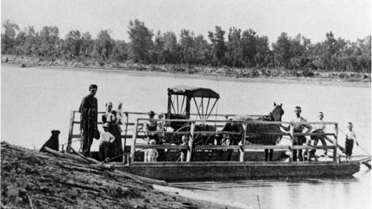
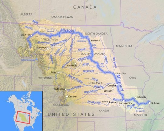
Most who are natives or residents of South Dakota have become so used to the Missouri River that we hardly think about the deep historical story behind this creation of nature.
First of all, many people don’t realize that the Missouri River is the longest river on the North American Continent… a lengthy 2314 miles from the Rocky Mountains in northwestern Montana to the plains of the state of Missouri and the city of St. Louis, where it empties in the Mississippi. The Missouri drains water from the southern areas of two Canadian Provinces, Alberta and Saskatchewan, and drains water from rivers in ten U.S. States: Montana, Wyoming, Colorado, North Dakota, South Dakota, Nebraska, Minnesota, Iowa, Kansas and Missouri.

The most famous historical reference to the mighty Missouri River came in 1804, when President Thomas Jefferson dispatched Meriwether Lewis and William Clark on an epic exploration of the American West. These two explorers followed the Missouri River up into what is now Montana and then crossed over the Great Divide of the Rocky Mountains, traveling to the Pacific Ocean further west.
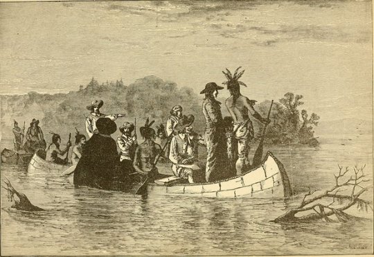
But the earliest reference to the Missouri River came from Louis Joliet and Jacques Marquette, fur traders from France who first entered the area in 1673. These two intrepid explorers established one of the largest fur trading posts in history at what became known as Fort Benton, Montana, near Great Falls.
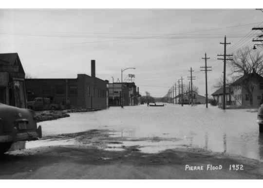
But for many of us, our earliest memories of the Missouri River came in the first half of the 1900’s when heavy snowfall in the mountain and the prairie states yielded devastating floods which annually spilled over the banks of the river and flooded the farm land along hundreds of miles along the “Muddy Missouri”.
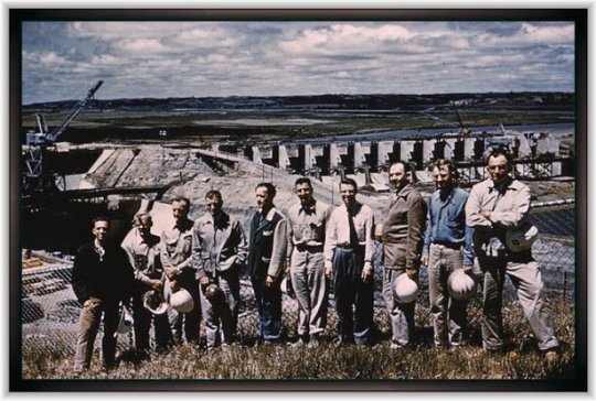
In 1944, Congress authorized the Flood Control Act, which authorized the U.S. Army Corps of Engineers to build a series of dams stretching from Montana to the Southeastern South Dakota town of Yankton. The largest of the four massive dams on the Missouri River Is Oahe located just north of South Dakota’s Capital City – Pierre.

On August 17, 1962, President John F. Kennedy came to Pierre to dedicate the Oahe Dam and the overall flood control project. There are six dams which are a part of the Flood Control Project: Fort Peck Dam in Montana. Garrison Dam in North Dakota. Oahe Dam at Pierre, South Dakota. Big Bend Dam, near Fort Thompson. Fort Randall Dam near Pickstown, and Gavins Point Dam just outside of Yankton.There are three major benefits that result from the building of the six dams, being the most commonly recognized. Water sports, swimming, boating, water skiing, sun bathing, and fishing have all exploded in popularity along the hundreds of miles of shoreline. The generation of electrical power for many towns and cities is an important benefit from the dams and flood control, which has saves towns and cities as well as farmers and ranchers and other nearby businesses all of whom benefit from the fact that while “A River Runs Through It” most of us rarely think of how we all benefited from taming “Mighty Missouri River”.
9 notes
·
View notes
Text
The French..
The French Meanwhile, by the late 1600s, France rivaled Spain in the mercantilist sweepstakes. Voyages down the Mississippi River from French bases in Canada by explorers such as Joliet, Marquette, and La Salle, and subsequent French claims to the vast lands drained from the west by the Mississippi,which they dubbed Louisiana (and which included all of present-day Oklahoma except the Panhandle) in honor of their dictatorial monarch, Louis XIV-helped establish this enhanced French power. From the 1718 founding of New Orleans at the mouth of the Mississippi into the Gulf of Mexico, French traders and explorers flocked northwest through Oklahoma rivers in search of furs. The French posed a grave threat to Spanish hegemony over present-day Oklahoma and, indeed, the entire western Mississippi River Valley. Their men proved to be active and vigorous travelers along rivers such as the Arkansas, Red, Canadian, Grand, and Verdigris. They formed alliances with influential Indian tribes such as the Comanches in the Southern Plains and the Wichitas in eastern Oklahoma, and in fact did not hesitate to intermarry with Indian girls. They also traded a galaxy of items to the Indians, including clothing, tools, and trinkets, and-unlike the Spanish-weapons, ammunition, and whiskey. Gradually, the French parlayed these practices into a loose control over most of present-day Oklahoma and the western Mississippi watershed. This ended, temporarily, in 1763, as England defeated the combined forces of Spain and France in the sprawling mercantilist Seven Years War, whose North American theater gained the name of the French and Indian War. That vast conflict exhausted all of its participants, including the English, who demanded the ceding of Florida by Spain. Read the entire Oklahoma story in John J. Dwyer’s The Oklahomans: The Story of Oklahoma and Its People volume 1 of a 2-part series on the 46th state and the people who make this state very special.
#oklahoma#history#john dwyer#the oklahomans#chocktaw#cherokee#seminole#chickasaw#sooners#boomers#89ers#land run#okies
0 notes
Link
0 notes
Text
10 Interesting Facts About The DuSable Bridge
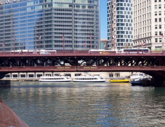
One of the most important bridges in the history of the city of Chicago is located right in the heart of the Downtown area of the city. In this post, you can discover the ultimate list of interesting facts about the DuSable Bridge, an iconic bridge with a couple of fascinating stories to tell!
1. It carries an important road over the Chicago River
The DuSable Bridge is not just one of the most historically important bridges in Chicago, Illinois, mainly because of its location, but also carries one of the most famous roads in the city. It carries Michigan Avenue across the Chicago River in Downtown Chicago, one of the main boulevards featuring the most important commercial areas in the city, including the so-called "Magnificent Mile." It has a north-south orientation and the northern part of the bridge is home to some of the most iconic buildings in the city, including the Wrigley Building and the Tribune Tower. The scenic Chicago Riverwalk is located just to its east as well.
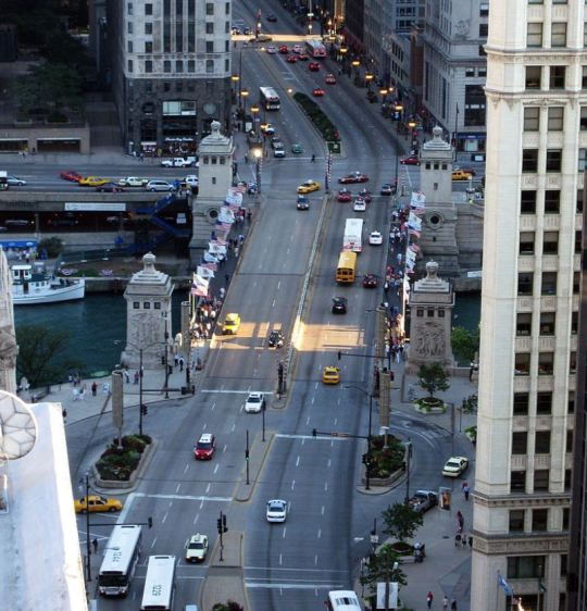
Aerial view of the bridge / David B. Gleason / https://creativecommons.org/licenses/by-sa/2.0
2. It was renamed in 2010 in honor of a particular Chicago resident
The original name of the bridge upon completion in the year 1920 was the "Michigan Avenue Bridge, a reference to the road it carries on its two decks. Because of its historically significant location, the bridge has been subject to being renamed all throughout its history. The first two official proposals were the "Marquette–Joliet Bridge," in honor of two explorers from the early days of the state of Michigan, and the "Fort Dearborn Bridge," a reference to a fort that was located here before. One of the most remarkable facts about the DuSable Bridge is that it was only renamed to its current name in the year 2010. This name is a reference to a man named Jean Baptiste Point du Sable (before 1750-1818), a trader of French-African descent who is considered to be the first non-indigenous resident of the city in 1780 and therefore the "Founder of Chicago."
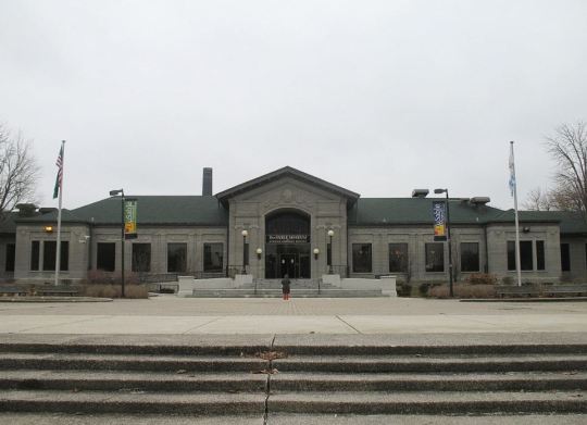
DuSable Museum of African American History / TonyTheTiger / https://creativecommons.org/licenses/by-sa/2.5/deed.en
3. The northern side of the bridge has unique historical value
The main reason that the bridge was named in honor of Jean Baptiste Point du Sable is that he built his house on the northern part of where the bridge is located today, near the mouth of the Chicago River, in the year 1780. The exact spot of his house is now an area referred to as "Pioneer Court," a plaza nestled in between the skyscrapers of Downtown Chicago, a sight that DuSable would watch in astonisment today, that's for sure! His house ended up being bought by a man named John Kinzie in 1800. He seriously expanded the structure and the house is therefore also sometimes referred to as the "Kinzie Mansion."
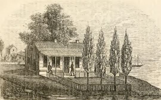
The house of DuSable / Laurent de Walick / Wiki Commons
4. The southern side was once the location of a United States fort
Just over 2 decades following the construction of the first non-indigenous house in Chicago, a fort was built on the southern part of where the bridge is located today. This fort was called "Fort Dearborn" and was completed in the year 1803. It was named in honor of Henry Dearborn (1751-1829), an American politician who served as the United States Secretary of War at the time. The original fort was completely destroyed during the War of 1812 in a battle now referred to as the "Battle of Fort Dearborn." It was rebuilt in 1816 but lost its purpose as a fortification in 1837. The fort eventually ended up being completely destroyed yet again in 1871 during the Great Fire of Chicago. Today, only a plaque can be found where the fort's southern perimeter wall once stood can be found.
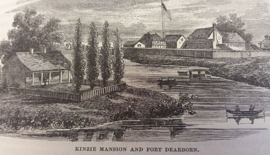
5. A bridge here was first proposed in the late 19th century
The first time that a bridge was proposed in this location was in the year 1891, followed by countless other proposals, ranging from a tunnel to a bascule bridge proposed by the Chicago Tribune in 1903. The first concrete idea came about in the year 1909 when the Burnham Plan of Chicago was created. This consisted of a wide boulevard and a bridge across the river at the location of the DuSable Bridge today. The first plan to be approved was that of a double-decked bridge in the year 1913, but subsequent legal battles delayed the start of the project until April 15, 1918, the day the construction started.
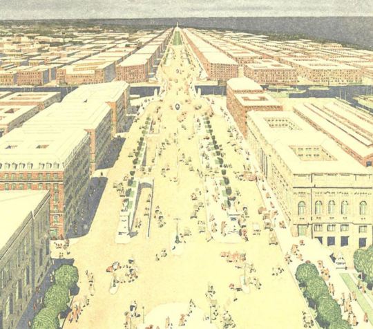
One of the proposed plans from 1909 / Wiki Commons
6. It almost looked like a famous bridge in Paris, France
The bridge was designed as a double-leaf, double-deck, fixed counterweight, trunnion bascule bridge, and the project was completed by the Bureau of Engineering of the Chicago Department of Public Works. Multiple designs were suggested, and perhaps the most notable was a suggestion to make the birdge look like the Pint Alexandre III in Paris, one of the most ornamented bridges in the city. Perhaps this design wouldn't have been that bad at all, especially with some of the most famous buildings in Chicago in the background, don't you think?
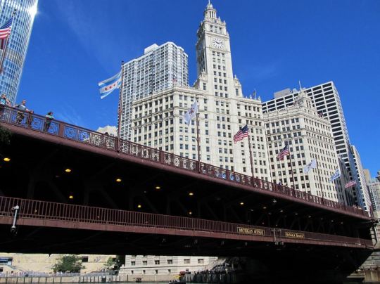
Detail of the bridge's design / Daryl Michell / https://creativecommons.org/licenses/by-sa/2.0/deed.en
7. The bridge held an amazing record upon completion
The architect of the project was the co-author of the 1909 Plan of Chicago, Edward H. Bennett (1874-1954). Apart from the Michigan Avenue Bridge, perhaps his most notable work was the Buckingham Fountain, the most prominent landmark in Grant Park. One of the most fascinating facts about the DuSable Bridge is that it's considered to be the first double-deck bridge in the world which featured roadways on both decks upon completion. Fast traffic was reserved for the upper deck, while the slower traffic, such as delivering trucks for the nearby docks, had to settle for the lower deck.
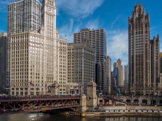
The iconic bridge / Atramos / https://creativecommons.org/licenses/by/2.0/deed.en
8. One of the piers was sunk to the bedrock below the river
The bridge has the capacity to open and close and counterweights are used for this mechanism. These weights drop into concrete pits of about 12 meters (40 feet) deep and lower about 10.5 meters (34.5 feet) below the surface of the water. These massive concrete pits on each side of the bridge are supported by 9 cylindrical concrete piers in order to provide stability. The 4 counterweights each weigh 1,447 tonnes (1,595 short tonnes). 17 of these piers are sunk at depths between 24 to 27 meters (80 to 90 feet), while one of them reaches the bedrock below to a depth of 33 meters (108 feet) below the river surface.

The bridge opened up / Stephen Hogan / https://creativecommons.org/licenses/by/2.0/
9. The bridgehouses are decorated with sculpted reliefs
Because the bridge has such historic importance in the city, 4 sculpted reliefs have been added in 1928 which depict scenes from the history of the city. These 4 reliefs are located on each of the 4 bridgehouses and depict: - The Discoverers - Depicts early explorers in the region, Louis Joliet, Jacques Marquette, René-Robert Cavelier, Sieur de La Salle, and Henri de Tonti. - The Pioneers - Depicts John Kinzie as he leads a group of people through the wilderness. - Defense - Depicts US Army Officer George Ronan during the 1812 Battle of Fort Dearborn. - Regeneration - Depicts workers rebuilding the city following the Great Chicago Fire of 1871. The first two reliefs are featured on the northern side of the bridge and were sculpted by James Earle Fraser (1876-1953) while the reliefs on the southern side were sculpted by Henry Hering (1874-1949).
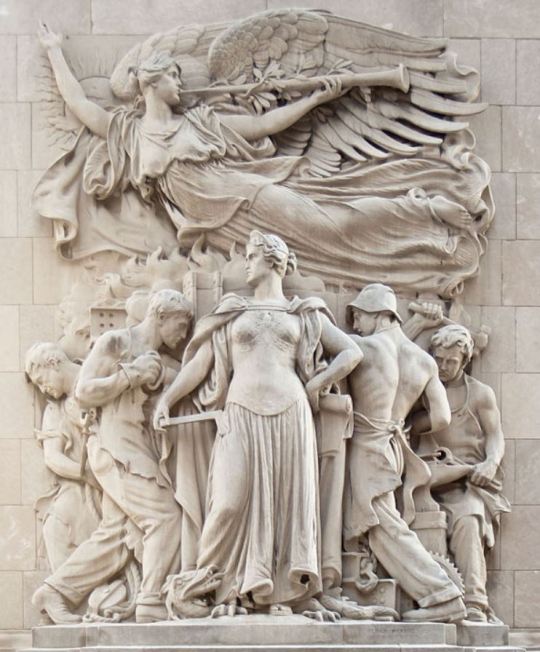
Regeneration by Henry Hering / Jeremy Atherton / https://creativecommons.org/licenses/by-sa/3.0/deed.en
10. The southwestern bridgehouse became a museum in 2006
The southwest bridgehouse is referred to as the "McCormick Bridgehouse & Chicago River Museum" and can be accessed from the Chicago Riverwalk. Here you can learn everything about the history of both the Chicago River and the DuSable Bridge. The museum was named in honor of the former owner of the Chicago Tribune newspaper, Robert R. McCormick (1880-1955), as his foundation raised $950,000 to make the establishment of the museum possible.
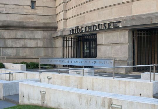
Entrance to the museum / Jeremy Atherton / https://creativecommons.org/licenses/by-sa/3.0/deed.en Read the full article
#Architecture#Bridges#Buildings#Chicago#DuSableBridge#DuSableBridgefacts#FamousBridges#FamousBuildings#LandmarksinChicago
0 notes