#lake or inland sea to the south of the grasslands
Explore tagged Tumblr posts
Text
Rogueport's Location
So in Paper Mario the Thousand Year Door at the beginning of the game Peach says the following in a letter to Mario. "Hello there, Mario! I am now on holiday traveling in the Mushroom Kingdom." This implies Rogueport is located within the Mushroom Kingdom or in other words continent. If one looks in the background one of Rogueport they will notice there is a trees in the background, this would imply it's in an lake or inland sea. This would be consistent with a lake or inland sea I have brought up before that is to the South of the Grasslands.
So similar to places like Lavalava Island I bet this body of water is where Rogueport is located. This also explains the presence of Toads and Goombas within Rogueport. This would also imply the Piantas living here moved from Isle Delfino to here.

#mario bros#super mario bros#mario#super mario#mario canon#mario hypothesis#mario lore#mario theory#paper mario#paper mario the thousand year door#paper mario ttyd#pmttyd#ttyd#rogueport#rogueport's location#rogueport is part of the mushroom kingdom#the mushroom kingdom#mushroom kingdom#mushroom continent#lake or inland sea to the south of the grasslands#paper mario lore
16 notes
·
View notes
Text
The Regions of Kishetal
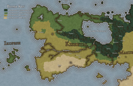
Pictured Above: An environmental map of the land of Kishetal

Pictured Above: A map of the 7 Kishic Regions
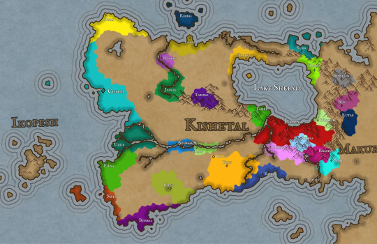
Pictured Above: A map of the Kishic City-States and their territories
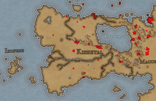
Pictured Above: A map of Significant Stable Forestfolk Populations
Here is a quick overview of the regions of Kishetal, the homeland of Narul and Ninma. And some good ol' maps. I'll be posting in the future about some of the creatures and forestfolk mentioned below!
As always send questions please!
Continues below the cut!
The Regions of Kishetal
1. The Red Cedar Mountains
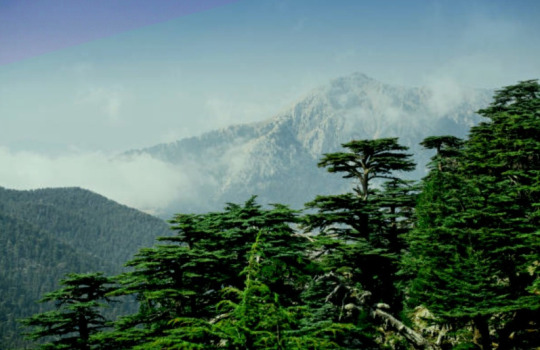
Pictured Above: The Red Cedar Mountains near Kepfis
The Red Cedar Mountains stretch from the Shabalic Sea in the north nearly to the Sea of Agitu in the south. The Red Cedar Mountains were formed in ancient times having already been present in the Age of Metal and Glass. However, the Red Cedar Mountains are not among the eleven “Chains of Sanctuary,” those mountain ranges around the planet in which humanity sheltered from the wrath of the gods during the Calamity. The predominant underlying stone of the RCM is limestone, with occasional but significant areas and deposits of serpentinite, basalt, and dolerite. The region experiences warm summers and cold winters, often with considerable snow and rainfall, particularly at higher elevations. The Mountains surround Lake Shebali, which acts as an inland sea and a source of food and transport for much of eastern Kishetal. At lower elevations, such as Labisa, the predominant vegetation is juniper and oak. Forests of black pine, cedar, and fir are dominant and common at higher elevations. The highest peaks are home to alpine meadows. Wild grapes, figs, and olives are all abundant in this region alongside their domesticated cousins.
Some fauna include wolves, jackals, wild goats, giant minks, wild bulls(aurochs), leopards, kishic lions, kishic tigers, caracals, roe deer, gazelle, wild boar, eagles, storks, horned rabbits, kishic brown bears, lynxes, and kishic ibex.
Very rarely found is the Kishic Elephant, actually a species of mammoth, these tiny pachyderms are about the same size as the average dairy cow. Only about 100 still survive in sheltered valleys to the north.
Examples of monstrous and magical Fauna including Flesh-eating deer, kiriki, dorasi, and the kutiri. While there are rumors of larger monsters such as dragons, these are mostly little more than legends and folklore. Though there is no telling what creatures could be hiding in the many caves and tunnels which dot the mountains.
There are numerous small forestfolk tribes which live in isolated areas.
(I will post more about that later)
2. The Felic Plain

Pictured Above: The Felic Plain north of Boshalum
The Felic Plains primarily consist of grassland with occasional patches of deciduous forest. The area is famed for its almond trees and its many wildflowers, including wild roses and hasir flowers. During the fall, great patches of the plains turn red with the blooming of hasir flowers.
The region experiences hot summers and mild but wet winters, which makes the region ideal for farming. As such, the Felic Plains act as the bread-basket of Kishetal. The region is split by the Aratshin River, which extends from Lake Shebali to the Green Sea. The plains are disrupted by an especially dense forested area known as the Garden. All attempts to settle the Garden have failed.
Fauna include, wolves, jackals, gazelles, wild bulls, kishic lions, deer, eagles, storks, horned rabbits, kishic brown bears, foxes, wild goats, polecats( which are popular pets), felic falcons, and hyenas.
The plains are home to several monstrous/magical species, including Flesh-eating deer, garudu, takmek, and the Unturu Serpent.
There are a handul of forestfolk tribes as well as a single hillfolk tribe in this region.
3. The Western Coast
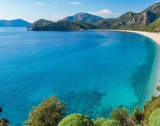
Pictured Above: The Western Coast near the city-state of Chibal
The Western Coast borders the Green Sea stretching from Bura in the north to Bisabal in the south. The ecoregion has a warm semi-tropical climate akin to a Mediterranean climate. Winter is the wettest season, and summer is the driest.
The Western coast consists primarily of three biomes. The deciduous forests in the north consist primarily of hornbeams, oaks, maples, cedar, and black pine. The central marshlands surrounding Udur have heavy concentrations of reeds, papyrus, poplar, and willow. The southern plains are similar to the Felic plain region though typically arider. Bay, olive, carob, and sweetgum are all common in this region. The Green Sea and its coast are home to many kinds of edible seaweed which form an essential part of the Chibalic and Buric diets.
Fauna include wild boars, foxes, jackals, wolves, badgers, wildcats, coastal brown bears, gazelles, deer, wild bulls, wild goats, and storks. Marine life includes dolphins, seals, whales, sea turtles, and many species of fish.
Monstrous fauna include bulari, sea-dragons, serpents, krinari, and ramitalek.
Aside from Ikopeshi's there are no surviving forestfolk tribes in this region.
4. The Northern Coast/Sheprian Forest
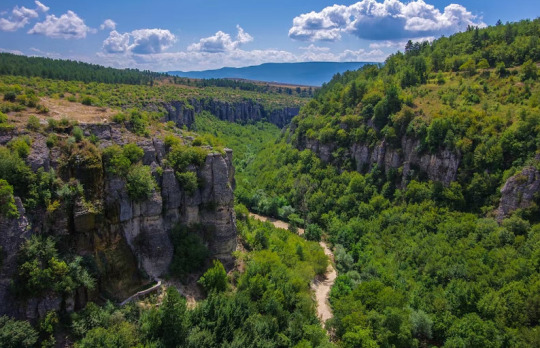
Pictured Above: The Sheprian Forest near Shepra
The Sheprian forest in the northern part of Kishetal is primarily composed of deciduous trees with occasional conifer patches at areas with higher elevations. Common trees include oak, chestnut, birch, hornbeam, black pine, cedar, and beech.
The climate is temperate with warm dry summers and cold wet winters. The north is typically thought of as the wildest region, with most city-states and settlements, including Shepra, clinging to the Corin river. Sheprian poetry is a unique variety of poetry, similar to the Japanese haiku, which originates from the forest festivals of the northern coast.
Fauna include wolves, jackals, gazelles, wild bulls, kishic lions, deer, eagles, storks, horned rabbits, kishic brown bears, foxes, wild goats, giant minks, horned rabbits, wild sheep, eagles, and kishic leopards.
Monstrous fauna include flesh-eating deer, garudu, kiriki, dorasi, and winged tigers.
This region contains the second highest concentration of forestfolk after the Red Cedar Mountains.
5. The Southern coast
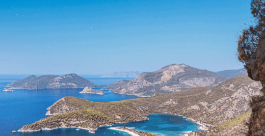
Placed Above: The Southern Coast near Bisabal
The Southern Coast consists of three regions; the southern deciduous forest, the scrubland, and the plains. The climate in the south is quite warm, with summers being hot and dry and winters mild in both temperature and rainfall. On rare occasions, the southern coast may experience heavy snowfall.
Major cities are sparse however, many villages dot the southern coast, many of these villages rely on piracy, preying primarily on Apunian and Jezaani ships traveling to and from the Western Coast.
Limestone plateaus and outcroppings are near the border of the southern coast, and the desert are said to be the remains of ancient buildings though this is not true.
Poplar, olive, bay, carob, almond, oaks, and umbrella pine are all common.
Fauna includes wolves, jackals, gazelles, wild bulls, kishic lions, deer, eagles, storks, horned rabbits, kishic brown bears, foxes, wild goats, polecats, felic falcons, kishic leopards, and hyenas.
The south is home to relatively few monstrous/magical species though it is home to the largest population of kiriki in Kishetal.
There are only two forestfolk populations in this region.
6. The Kipsian Desert
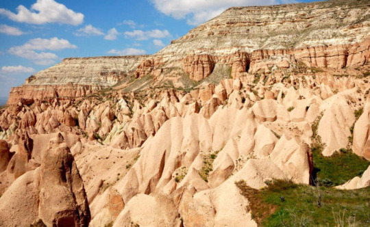
Pictured Above: The limestone formations of the Kipsian desert south east of Kipsu.
The Kipsian desert is the least populated region of Kishetal as the arid environment is not conducive to agriculture. Ruins of older civilizations suggest that the area may have once been more hospitable.
Plant life is sparse and largely limited to hardy shrubs and grasses. The region is famous for its carob and the candies and sweets produced from the carob by its inhabitants. Mesa, plateaus, pillars, and other stone structures are common; foreign visitors often visit the region seeking religious or spiritual enlightenment amongst the arches and columns. Many never leave.
Fauna include jackals, gazelles, kishic lions, deer, gazelle, wild asses, and hyenas. The Kipsian desert is also the only region in Kishetal in which the kishic ostrich and oryx survive.
Monstrous fauna include Flesh-eating deer, takmek, sikara, kiriki, and giant lions.
There are no forestfolk populations here.
7. The Makurian Steppe
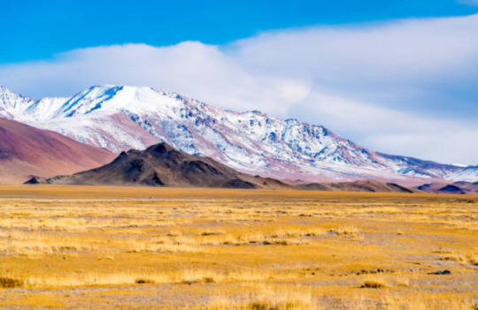
Pictured Above: The Makurian Steppe north of Shebal
The Makurian steppe is massive, spreading over most of western Masia. Only a tiny sliver of that vast extent falls in Kishetal. Trees are almost entirely absent. Vast expanses of grass-covered hills define the area. To the north of the steppe is the Shabalic forest, and to the south is the Jezaaic desert.
The heavy presence of sagebrush, sedges, and grasses and the relatively dry climate have led to a preference for a nomadic and pastoralist lifestyle. Makurian tribes regularly raid and intrude in the region, with their westward pushes typically being halted by the mountains.
Fauna include wild horses, wild asses, wild bulls, jackals, gazelle, deer, mountain sheep, macuri lions, and leopards.
Monstrous fauna include the tomob and the wulut.
There are only 3 native forestfolk populations in this region.
As always ask questions! Anything! And if y'all like this I might do this with some other regions.
@patternwelded-quill @flaneurarbiter @skyderman @blackblooms @roach-pizza @illarian-rambling @dezerex @theocticscribe @axl-ul, @persnickety-peahen @angie-j-kay
@surroundedbypearls I was looking through my intro post and I just realized I've been completely forgetting to put you in the taglist! Sorry about that!
#writeblr#writing#fantasy#worldbuilding#writer#fantasy writing#queer fantasy#fantasy world#testamentsofthegreensea#fantasy map#fantasy novel#fantasy worldbuilding#world building#narul#writblr
60 notes
·
View notes
Text

Lunae Palus is a region of Mars that sits on the southeast of the Continent of Tharsis, and is home to the Martian planetary capital district of Bradbury in the state of the same name. It is a mostly temperate region with a large continental cool climate as you get into the highlands. Even 80 years after habitability was declared, the region is considered "incomplete" like much of Mars with rivers and lake building projects still ongoing. In spite of this Lunae Palus boasts huge stretches of inhabitable land overlaid by wide rivers, and the enormous Mariner Sound to the South. Expansive grasslands give way to thick forests; Arean Poplar, Longan, and Blood Apple and Black Maple straddle rivers and lakes, while in the southern highlands you'll find 100 meter high Martian Sequoia, or "Ironwood" trees (named for the ribbons of iron in their wood, bioleached from the soil).
Inland, Lunae Palus' rolling hills and relatively few large craters makes it an ideal site for orchards and farmland. Heinlein, Xanthe, and Viking are known for producing some of the best wine on the planet, while Maja, Lunae, and Kanva grow a good deal of Martian wheat, barley, hops, fruit, and produce. The megalakes of Juventae and Hebes feed huge stocks of freshwater fish, but also huge navigable rivers that link the Lunae Palus interior with the Great Boreal Ocean.
Major population centers are concentrated along the coasts and deep water ports of major rivers. The greatest of these is Chamba, a port city for the stars and sea. Chamba stands at the base of the Infinite Mandir, a Space Elevator with access to a deep water port via the mouth of the Ravi River. From here cargo gondolas carry goods to and from Camba's ports across the wider solar system, while container ships in those ports can then reach the rest of Mars. While not as developed as New Richmond to the east, Akkad is the heart of a growing megaregion around Chimbote Bay.
The Infinite Mandir's origins are a dark chapter in Martian history, as one of the first Hindu temples on Mars was destroyed to make way for the anchor point of the elevator. In the decades that followed, the Martian Hindu community successfully sued the elevator's stakeholders for damages, and gained rights over the anchor point. Those rights lasted all of 17 years before the Interplanetary Trade Commission saw the consolidation of all major infrastructure under the Interplanetary Trade Commission. Over the decades, the terminal to the elevator was eventually rebuilt into an expansive structure in the Nagara style, which includes a new temple at the North entrance to the complex. While not as populated as the Margaritifer lowlands to the east, Lunae Palus is home to some of Mars' most desirable tourist destinations and national parks. The Mariner Sound is by far the most popular attraction in the region, pulling in tourists from across Mars, the wider solar system, and even from other star systems. Ambassadors and students from exoplanets usually make a point to visit the largest canyon in the Solar System during their long residences away from home. Cruise lines offer tours of the Sound beginning in Bradbury before depositing their passengers in Gramercy at the far end of the Candor Canal. Gramercy is the last stop for most visiting Lunae Palus and as such the town is all but engineered to separate guests from their money. Hotels, spas, brothels, and casinos are everywhere overlooking the calm waters of the Candor Canal, along with some of the few beaches on Mars, made possible by a mix of synthetic and real terran sand.
Thanks to all my patrons who help make these maps possible: www.patreon.com/SeanMcKnight
3 notes
·
View notes
Text
I brought rain to Iran. I started working on it in 2017. In 2018 I brought rain to Iran. I brought rain to dry, deserts, and other bad regions of Iran. I made floods in Iran. My intention was not flood. I wanted to provide water for people and I wanted to ressurect the dead land after its death. I resurrected the land. I created thousands of lakes and inland seas. I created several mighty rivers. I made thousands of small rivers. I created springs and waterfalls. The land became green. Everytime I had looked at videos of Iran they were showing deserts and dry regions without vegetation. But after I brought rain all the videos became grasslands, lush, and green in Iran. I am also building forests in Iran. Forests, ecosystems, and biosphere are very important. Rain also provides water for cities, drinking, consumption, shower, washing dishes, and other activities. Water is also needed for many industrial activities. I brought rain. One of the reason Iran and Middle East are very weak is the lack of water. Climate makes them weak. When there is no water there is no human. When there is no water there is no farming and food production. When there is no water there is no forest and grasslands. When there is no water there is no factory. Majority of landmass of Iran was inhabitable. Nobody could live in about 95 percent of Iran. People had to abandon glorious civilization and cities due to lack of water. They had relocated to near of rivers and ghanat. So population of Iran is also very low. Iran only has 85 million people. But I bring rain. Population of Iran can increase to 2 billion people if there is rain in Iran. Improvement of Climate condition in Iran will create more habitable lands. There will be many new cities, metropolitans, towns, villages, farmlands, grassland, ecosystems, biosphere, human civilizations, and other good things. I bring rain. But they never thanked me when I was in Iran. In America they tried to kill me two years ago when they took me in airport. They did not let me go to Iran. Then they tried to kill me in hospital. They moved me to another hospital. I was in coma for one month. After I woke up from coma I found out I was very sick. They were not giving me water in hospital. I was thirsty for months. But I was bringing rain to Iran, Middle East, Horn of Africa, Arabian Peninsula, North Africa, Ghafghaz, South West Russia, Balkan, India, Central Asia, Afghanistan, Pakistan, Himalaya, and west China. I was providing rain to most dry regions of the world. They tried to kill me in hospital. They did not give me water to drink for months. I became better and I left the hospital. I went back to Iran about a year later. I was in Iran for 2 years. Nobody talked to me in Iran. I was waiting for them to come and crown me Makan Abazari Shahan Shah Iran. But they did not come. So I overthrew Iran to be crowned Makan Abazari Shahan Shah Iran. Repeatedly overthrow Iran again and again until I am crowned Makan Abazari Shahan Shah Iran. Prepare my coronation. Iran must crown me Makan Abazari Shahan Shah Iran. Iran has only one choice and it is to crown me Makan Abazari Shahan Shah Iran. I bring rain to Iran. So I must reign in Iran. Rain in Iran.
I bring rain. I bring rain to Iran and other parts of the world. I am resurrecting the land.
Iran must crown me Makan Abazari Shahan Shah Iran.
Https://youtu.be/aHR070QB_GY
Rain in Iran, Middle East, Horn of Africa, North Africa, Ghafghaz, Arabian Penunsila, Middle East, Central Asia, Greater Middle East, Greater Iran, South Asia, South West Russia, West China, Himalaya, and other regions. Hurricane and famine North America. Earthquake in South East Asia, Indonesia, Australia, Southern Africa, South America, North America, and Europe. Volcano in Canada and Britain Tornado many regions of the earth. Rain Systems Iran and Middle East. Overthrow Iran repeatedly to crown Makan Abazari Shahan Shah Iran. Iran must crown me Makan Abazari Shahan Shah Iran.
Middle East, Horn of Africa, North Africa, Central Asia, Arabian Penunsila, Middle East, Ghafghaz, Greater Middle East, Greater Iran, South Asia, Russia, China, Himalaya, and other regions are provinces of Iran. The capital city is in Iran between Persian Gulf and Caspian Sea. Makan Abazari Shahan Shah Iran is the Government. The name of unified Empire is Iran. Makan Abazari Shahan Shah Iran is the Government.
Iraq, Syria, Lebanon, Palestine, Israel, Gaza, Sinai, Suez, Egypt, Jordan, Saudi Arabia, Oman, UAE, Qatar, Bahrain, Kuwait, Turkey, Azerbaijan, Armenia, Georgia, Turkmanistan, Uzbakistan, Kyrgyzstan, Tajikstan, Kazakhstan, Russia, Afghanistan, China, Pakistan, India, Bulgaria, Romania, Greece, Balkan, Italy, France, Spain, Portugal, Morroco, Gibraltar, Bob Al-Mandib, Algeria, Tunisia, Libya, Sudan, South Sudan, Eritrea, Ethiopia, Djibouti, Somalia, Somaliland, Kenya, Uganda, Red Sea, Gulf of Eden, Medditrnean Sea, and Black Sea are provinces of Iran. The capital city is in Iran between Persian Gulf and Caspian Sea. Makan Abazari Shahan Shah Iran is the Government. The name of unified Empire is Iran. Makan Abazari Shahan Shah Iran is the Government.
https://express.adobe.com/page/UNHXCnGu0Zzlt/ Crown me Makan Abazari Shahan Shah Iran. Iran must officially crown me Makan Abazari Shahan Shah Iran. Overthrow Iran repeadetly until I am crowned Makan Abazari Shahan Shah Iran. Makan Abazari Shahan Shah Iran, Makan Abazari The Supreme of Climate, Makan Abazari The Supreme of Geophysics, Makan Abazari The Supreme of Weather Warfare, Makan Abazari The Messenger of God, The King of Kings Makan Abazari Shahan Shah Iran the first king of Makanian Dynasty,
https://express.adobe.com/video/mSwInVJRl4Wy7
Prepare Iran for coronation of Makan Abazari Shahan Shah Iran. Prepare Makan Abazari Shahan Shah Iran for coronation. Crown me Makan Abazari Shahan Shah Iran.
President Raisi of Iran is dead. They killed him to crown me Makan Abazari Shahan Shah Iran. I did not kill Raisi. I did not order them to kill Raisi. But we know they killed him to crown me Makan Abazari Shahan Shah Iran. We shall overthrow Uran again and again repeatedly until Iran crowns me Makan Abazari Shahan Shah Iran. We overthrow current and all next governments of Iran until they crown me Makan Abazari Shahan Shah Iran. Iran must crown me Makan Abazari Shahan Shah Iran as soon as possible. Prepare me and Iran for coronation of Makan Abazari Shahan Shah Iran. All of peoples, governments, forces, regime, mind controllers, staff, and all others must work together to crown me Makan Abazari Shahan Shah Iran. I want all of power of Iran to work to crown me Makan Abazari Shahan Shah Iran. I want all of nation of Iran to work to crown me Makan Abazari Shahan Shah Iran.
https://express.adobe.com/video/82wzpaxR9cnSd https://express.adobe.com/video/xB40Gsuy3jyLP
Protests in Iran to crown me Makan Abazari Shahan Shah Iran. Make revolution in Iran to crown me Makan Abazari Shahan Shah Iran. Iran must crown me Makan Abazari Shahan Shah Iran. Don’t overthrow me. I am already Makan Abazari Shahan Shah Iran and I will forever be Makan Abazari Shahan Shah Iran. Iran must crown me Makan Abazari Shahan Shah Iran. Crown me Makan Abazari Shahan Shah Iran.
Crown me Makan Abazari Shahan Shah Iran.
https://m.youtube.com/watch?v=oU410OijVNs
Overthrow Iran repeadetly until I am Crowned Makan Abazari Shahan Shah Iran.
Make revolution in Iran to crown me Makan Abazari Shahan Shah Iran. Iran must crown me Makan Abazari Shahan Shah Iran. Don’t overthrow me. I am already Makan Abazari Shahan Shah Iran and I will forever be Makan Abazari Shahan Shah Iran. Iran must crown me Makan Abazari Shahan Shah Iran. Crown me Makan Abazari Shahan Shah Iran.
Crown me Makan Abazari Shahan Shah Iran.
https://express.adobe.com/video/3BEMykgLlAwsC
All capabilities and functions of the code in a manner to crown me Makan Abazari Shahan Shah Iran. All capabilities and functions of the code to overthrow Iran repeatedly until Iran crowns me Makan Abazari Shahan Shah Iran. Overthrow all current and all future governments, regimes, systems, nezam, leaders, supreme leaders, presidents, kings, shah, Shahan shah, Emperor, the King of Kings, Prime Ministers, and all other leaders of Iran until I am crowned Makan Abazari Shahan Shah Iran.
Repeatedly overthrow Iran until I am crowned Makan Abazari Shahan Shah Iran.
Make revolution in Iran to crown me Makan Abazari Shahan Shah Iran. Iran must crown me Makan Abazari Shahan Shah Iran. Don’t overthrow me. I am already Makan Abazari Shahan Shah Iran and I will forever be Makan Abazari Shahan Shah Iran. Iran must crown me Makan Abazari Shahan Shah Iran. Crown me Makan Abazari Shahan Shah Iran.
Crown me Makan Abazari Shahan Shah Iran.
https://www.aparat.com/v/2jDsT Repeatedly overthrow Iran until I am crowned Makan Abazari Shahan Shah Iran.
Make revolution in Iran to crown me Makan Abazari Shahan Shah Iran. Iran must crown me Makan Abazari Shahan Shah Iran. Don’t overthrow me. I am already Makan Abazari Shahan Shah Iran and I will forever be Makan Abazari Shahan Shah Iran. Iran must crown me Makan Abazari Shahan Shah Iran. Crown me Makan Abazari Shahan Shah Iran.
Crown me Makan Abazari Shahan Shah Iran.
https://express.adobe.com/video/mSwInVJRl4Wy7
Crown Makan Abazari Shahan Shah Iran.
Prepare Iran for coronation of Makan Abazari Shahan Shah Iran. Prepare Makan Abazari Shahan Shah Iran for coronation. This code crowns Makan Abazari Shahan Shah Iran.
https://express.adobe.com/video/AKJMHBmFUg9jR Work at max efficiency and max capacity building Palaces and Mansions for Makan Abazari Shahan Shah Iran.
https://express.adobe.com/page/UNHXCnGu0Zzlt/ Crown me Makan Abazari Shahan Shah Iran. Iran must officially crown me Makan Abazari Shahan Shah Iran. Overthrow Iran repeadetly until I am crowned Makan Abazari Shahan Shah Iran. Makan Abazari Shahan Shah Iran, Makan Abazari The Supreme of Climate, Makan Abazari The Supreme of Geophysics, Makan Abazari The Supreme of Weather Warfare, Makan Abazari The Messenger of God, The King of Kings Makan Abazari Shahan Shah Iran the first king of Makanian Dynasty,
0 notes
Text
The 8 national parks in japan
Japan, a mesmerizing blend of ancient tradition and cutting-edge modernity, captivates with its vibrant culture, stunning landscapes, and technological innovation. From the serene temples of Kyoto to the bustling streets of Tokyo, it's a land where history meets the future, offering visitors a rich tapestry of experiences, from serene tea ceremonies to neon-lit skyscrapers.
Here are 8 of the most well-known national parks in Japan:
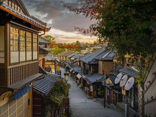
1. Fuji-Hakone-Izu National Park:
Famous for Mount Fuji, Japan's highest peak, this park offers stunning views of the iconic volcano, hot springs, and beautiful lakes. Also Read: Germany visa
2. Shiretoko National Park:
Located on the Shiretoko Peninsula in Hokkaido, this park is known for its diverse wildlife, including brown bears and deer, as well as its picturesque landscapes, including cliffs, waterfalls, and hot springs. Also Read: Canada visa
3. Aso-Kuju National Park:
Situated in Kyushu, this park is home to Mount Aso, one of the world's largest volcanic calderas, as well as scenic landscapes, grasslands, and hiking trails. Also Read: Singapore visa
4. Daisetsuzan National Park:
Also located in Hokkaido, this park is known for its rugged mountains, deep valleys, and alpine scenery, as well as its diverse flora and fauna. Also Read: Vietnam visa
5. Ogasawara National Park:
A UNESCO World Heritage Site, this park encompasses the Ogasawara Islands, a remote archipelago located south of Tokyo, known for their unique ecosystems and marine biodiversity. Also Read: Azerbaijan visa
6. Setonaikai National Park:
Spanning several islands and coastal areas in the Seto Inland Sea, this park offers scenic views, historic sites, and opportunities for outdoor activities such as hiking, diving, and island hopping. Also Read: south korea visa
7. Towada-Hachimantai National Park:
Located in the northern Tohoku region, this park includes Lake Towada, one of Japan's most beautiful lakes, as well as volcanic landscapes, forests, and hot springs. Also Read: Egypt visa
8. Chichibu-Tama-Kai National Park:
Close to Tokyo, this park offers a retreat into nature with mountains, forests, rivers, and waterfalls, as well as cultural sites such as temples and shrines. Also Read: Bangladesh visa
Conclusion
In conclusion, Japan's 8 national parks offer a stunning array of natural wonders, from majestic mountains to pristine coastlines. Exploring these parks provides a deep dive into Japan's rich cultural and ecological heritage. While planning your visit, remember to check japan visa requirements, ensuring a smooth and enjoyable journey into Japan's breathtaking landscapes.
0 notes
Text
Amazing Earth: Satellite Images from 2020
In the vastness of the universe, the life-bringing beauty of our home planet shines bright. During this tumultuous year, our satellites captured some pockets of peace, while documenting data and striking visuals of unprecedented natural disasters. As 2020 comes to a close, we’re diving into some of the devastation, wonders, and anomalies this year had to offer.
NASA’s fleet of Earth-observing satellites and instruments on the International Space Station unravel the complexities of the blue marble from a cosmic vantage point. These robotic scientists orbit our globe constantly, monitoring and notating changes, providing crucial information to researchers here on the ground.
Take a glance at 2020 through the lens of NASA satellites:
A Delta Oasis in Southeastern Kazakhstan
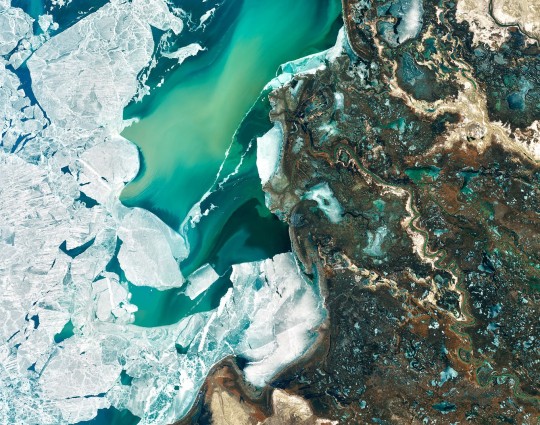
Seen from space, the icy Ili River Delta contrasts sharply with the beige expansive deserts of southeastern Kazakhstan.
When the Operational Land Imager (OLI) on Landsat 8 acquired this natural-color image on March 7, 2020, the delta was just starting to shake off the chill of winter. While many of the delta’s lakes and ponds were still frozen, the ice on Lake Balkhash was breaking up, revealing swirls of sediment and the shallow, sandy bed of the western part of the lake.
The expansive delta and estuary is an oasis for life year round. Hundreds of plant and animal species call it home, including dozens that are threatened or endangered.
Fires and Smoke Engulf Southeastern Australia
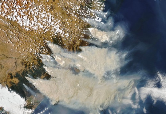
A record-setting and deadly fire season marred the beginning of the year in Australia. Residents of the southeastern part of the country told news media about daytime seeming to turn to night, as thick smoke filled the skies and intense fires drove people from their homes.
This natural-color image of Southeastern Australia was acquired on January 4, 2020, by the Moderate Resolution Imaging Spectroradiometer (MODIS) on NASA’s Aqua satellite. The smoke has a tan color, while clouds are bright white. It is likely that some of the white patches above the smoke are pyrocumulonimbus clouds—clouds created by the convection and heat rising from a fire.
Nighttime Images Capture Change in China
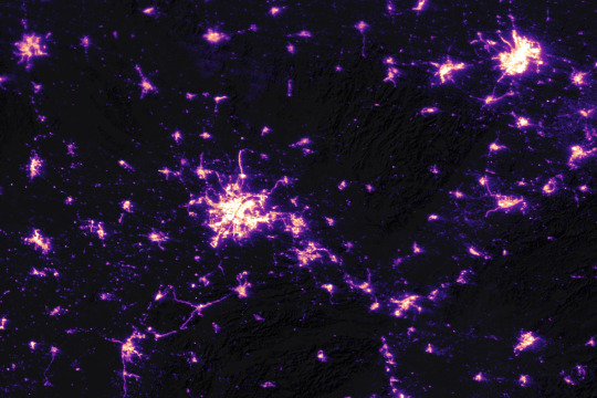
A team of scientists from NASA’s Goddard Space Flight Center (GSFC) and Universities Space Research Association (USRA) detected signs of the shutdown of business and transportation around Hubei province in central China. As reported by the U.S. State Department, Chinese authorities suspended air, road, and rail travel in the area and placed restrictions on other activities in late January 2020 in response to the COVID-19 outbreak in the region.
A research team analyzed images of Earth at night to decipher patterns of energy use, transportation, migration, and other economic and social activities. Data for the images were acquired with the Visible Infrared Imaging Radiometer Suite (VIIRS) on the NOAA–NASA Suomi NPP satellite (launched in 2011) and processed by GSFC and USRA scientists. VIIRS has a low-light sensor—the day/night band—that measures light emissions and reflections. This capability has made it possible to distinguish the intensity, types, and sources of lights and to observe how they change.
The Parched Paraná River
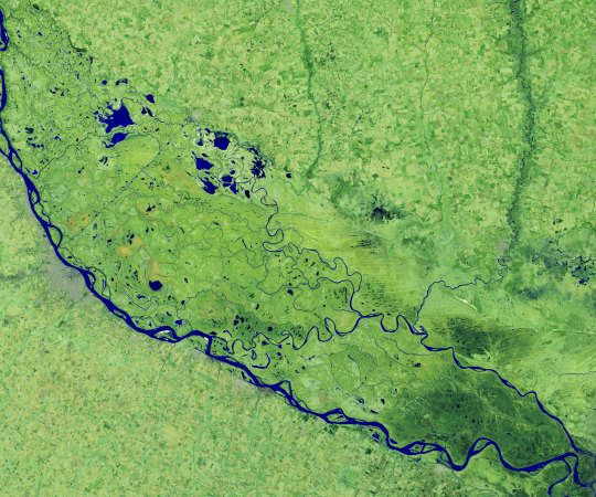
Though a seemingly serene oasis from above, there is more to this scene than meets the eye. On July 3, 2020, the Operational Land Imager (OLI) on Landsat 8 captured this false-color image of the river near Rosario, a key port city in Argentina. The combination of shortwave infrared and visible light makes it easier to distinguish between land and water. A prolonged period of unusually warm weather and drought in southern Brazil, Paraguay, and northern Argentina dropped the Paraná River to its lowest water levels in decades. The parched river basin has hampered shipping and contributed to an increase in fire activity in the delta and floodplain.
The drought has affected the region since early 2020, and low water levels have grounded several ships, and many vessels have had to reduce their cargo in order to navigate the river. With Rosario serving as the distribution hub for much of Argentina’s soy and other farm exports, low water levels have caused hundreds of millions of dollars in losses for the grain sector, according to news reports.
Historic Fires Devastate the U.S. Pacific Coast
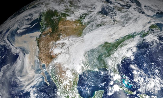
Climate and fire scientists have long anticipated that fires in the U.S. West would grow larger, more intense, and more dangerous. But even the most experienced among them have been at a loss for words in describing the scope and intensity of the fires burning in West Coast states during September 2020.
Lightning initially triggered many of the fires, but it was unusual and extreme meteorological conditions that turned some of them into the worst conflagrations in the region in decades.
Throughout the outbreak, sensors like the Visible Infrared Imaging Radiometer Suite (VIIRS) and the Ozone Mapping and Profiler Suite (OMPS) on the NOAA-NASA Suomi NPP satellite collected daily images showing expansive, thick plumes of aerosol particles blowing throughout the U.S. West on a scale that satellites and scientists rarely see.
This image shows North America on September 9th, 2020, as a frontal boundary moved into the Great Basin and produced very high downslope winds along the mountains of Washington, Oregon, and California. The winds whipped up the fires, while a pyrocumulus cloud from the Bear fire in California injected smoke high into the atmosphere. The sum of these events was an extremely thick blanket of smoke along the West Coast.
The Sandy Great Bahama Bank
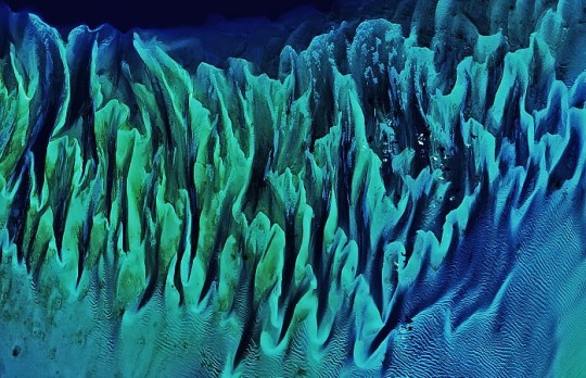
Though the bright blues of island waters are appreciated by many from a sea-level view, their true beauty is revealed when photographed from space. The underwater masterpiece photographed above is composed of sand dunes off the coast of the Bahamas.
The Great Bahama Bank was dry land during past ice ages, but it slowly submerged as sea levels rose. Today, the bank is covered by water, though it can be as shallow as two meters (seven feet) deep in places. The wave-shaped ripples in the image are sand on the seafloor. The curves follow the slopes of the dunes, which were likely shaped by a fairly strong current near the sea bottom. Sand and seagrass are present in different quantities and depths, giving the image it’s striking range of blues and greens.
This image was captured on February 15th, 2020, by Landsat 8, whose predecessor, Landsat 7, was the first land-use satellite to take images over coastal waters and the open ocean. Today, many satellites and research programs map and monitor coral reef systems, and marine scientists have a consistent way to observe where the reefs are and how they are faring.
Painting Pennsylvania Hills
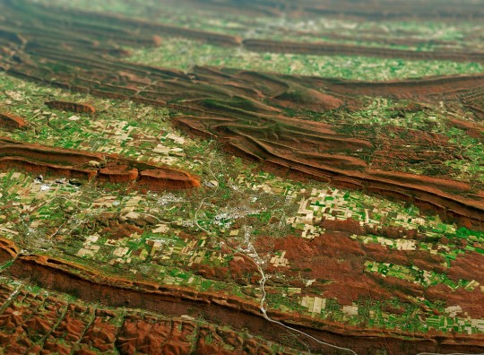
Along with the plentiful harvest of crops in North America, one of the gifts of Autumn is the gorgeous palette of colors created by the chemical transition and fall of leaves from deciduous trees.
The folded mountains of central Pennsylvania were past peak leaf-peeping season but still colorful when the Operational Land Imager (OLI) on the Landsat 8 satellite passed over on November 9, 2020. The natural-color image above shows the hilly region around State College, Pennsylvania overlaid on a digital elevation model to highlight the topography of the area.
The region of rolling hills and valleys is part of a geologic formation known as the Valley and Ridge Province that stretches from New York to Alabama. These prominent folds of rock were mostly raised up during several plate tectonic collisions and mountain-building episodes in the Ordovician Period and later in the creation of Pangea—when what is now North America was connected with Africa in a supercontinent. Those events created the long chain of the Appalachians, one of the oldest mountain ranges in the world.
A Dangerous Storm in the Night
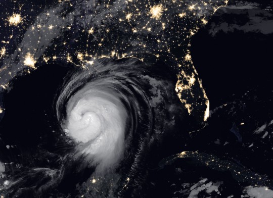
Ominous and looming, a powerful storm hovered off the US coastline illuminated against the dark night hues.
The Visible Infrared Imaging Radiometer Suite (VIIRS) on NOAA-20 acquired this image of Hurricane Laura at 2:20 a.m. Central Daylight Time on August 26, 2020. Clouds are shown in infrared using brightness temperature data, which is useful for distinguishing cooler cloud structures from the warmer surface below. That data is overlaid on composite imagery of city lights from NASA’s Black Marble dataset.
Hurricane Laura was among the ten strongest hurricanes to ever make landfall in the United States. Forecasters had warned of a potentially devastating storm surge up to 20 feet along the coast, and the channel might have funneled that water far inland. It did not. The outcome was also a testament to strong forecasting and communication by the National Hurricane Center and local emergency management authorities in preparing the public for the hazards.
A Windbreak Grid in Hokkaido
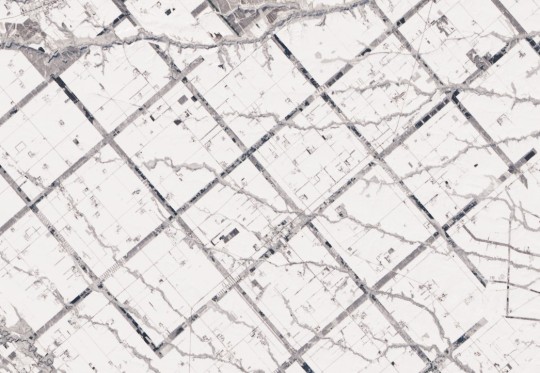
From above, the Konsen Plateau in eastern Hokkaido offers a remarkable sight: a massive grid that spreads across the rural landscape like a checkerboard, visible even under a blanket of snow. Photographed by the Operational Land Imager (OLI) on Landsat 8, this man-made design is not only aesthetically pleasing, it’s also an agricultural insulator.
The strips are forested windbreaks—180-meter (590-foot) wide rows of coniferous trees that help shelter grasslands and animals from Hokkaido’s sometimes harsh weather. In addition to blocking winds and blowing snow during frigid, foggy winters, they help prevent winds from scattering soil and manure during the warmer months in this major dairy farming region of Japan.
Shadows from a Solar Eclipse
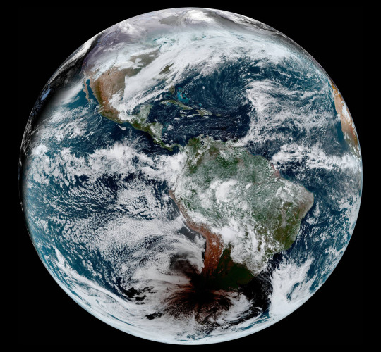
Formidable, rare, and awe-inspiring — the first and only total solar eclipse of 2020 occurred on December 14, with the path of totality stretching from the equatorial Pacific to the South Atlantic and passing through southern Argentina and Chile as shown in the lower half of the image above. The Advanced Baseline Imager (ABI) on Geostationary Operational Environmental Satellite 16 (GOES-16) captured these images of the Moon’s shadow crossing the face of Earth.
The “path of totality” (umbral path) for the eclipse was roughly 90 kilometers (60 miles) wide and passed across South America from Saavedra, Chile, to Salina del Eje, Argentina. While a total eclipse of the Sun occurs roughly every 18 months, seeing one from any particular location on Earth is rare. On average, a solar eclipse passes over the same parcel of land roughly every 375 years. The next total solar eclipse will occur on December 4, 2021 over Antarctica, and its next appearance over North America is projected for April 8, 2024.
For additional information and a look at more images like these visit NASA’s Earth Observatory.
Make sure to follow us on Tumblr for your regular dose of space: http://nasa.tumblr.com.
#NASA#Earth#science#earth pictures#planet earth#solar eclipse#eclipse#oceans#solar system#planets#space#satellite#stunning photos
2K notes
·
View notes
Text
Sri Lanka - An underrated destination that needs to be Discovered.

When discussing Sri Lanka, the first question that come to mind is: Is Sri Lanka is safe for tourists?
Here is the response to this question.
Is Sri Lanka is safe for tourists?
There is no doubt that Sri Lanka is completely safe for travelers.
Our recent visit to Sri Lanka revealed that there are no restrictions for travelers in Sri Lanka, and the locals were very welcoming to tourists.
There were cleaned and maintained roads, streets, and tourist attractions.
As a result, the conclusion is that Sri Lanka is completely safe for tourism. Sri Lanka is ranked among the top 20 best destinations to visit in the world.
Here, is the reason Why
Beginning with the mountainous states of Sri Lanka.
Sri Lanka is one of the world's most famous islands, and it has remained so for generations. This lovely island, known as "a tear drop in the Indian Ocean," has been recorded in ancient writings from Europe, Arabia, and India.
Sri Lanka is also called as a hill country
The three best hill station in Sri Lanka are:
Nuwara Eliya - The town of Nuwara Eliya is best known in Sri Lanka for its tea industry. Apart from the tea plantations, popular attractions in the town include Horton Plains National Park, Gregory Lake, and Sita Temple.
Kandy - Is known as a pilgrimage destination for the Temple of the Tooth Relic, a UNESCO World Heritage Site. Due to the importance and spiritual significance of this temple, Kandy is a spiritual city.
Ella - is popular with both day hikers and more experienced trekkers. Little Adam's Peak and Ella Rock are two popular excursions in the area, not to mention Ravana Falls and other nearby waterfalls.
Sri Lanka is fast gaining international recognition as one of the world's most stunning beach locations.
The Top 3 famous Beaches in Sri Lanka are:-
Hiriketiya Beach - Is a public beach in Dikwella, Matara district. It's a little beach with good surfing waves. There are a few restaurants and hotels in the surrounding neighbourhood, which is serene and peaceful. Surfers will love Hiriketiya Beach.
Bentota Beach - is a coastal town in Sri Lanka's Southern Province, located in the Galle District. It is about 65 kilometers (40 miles) south of Colombo.
Mirissa Beach - Is also known as the "Whale Watching Beach." Mirissa is a tiny town on Sri Lanka's south coast, in the Matara District of the Southern Province.
Top tourists attractions in Sri Lanka are:-
Yala National Park -
This is where you may go on a safari in the Sri Lankan tradition. The large national park that borders the Indian Ocean is home to a broad range of ecosystems. From the coastal sea habitat to grasslands and tropical rainforests inland.
Colombo Lotus Tower -
One of the top tourist attractions in Sri Lanka is also one of the newest and tallest structures in the country. The Colombo Lotus Tower, South Asia's largest free-standing tower, debuted in 2019. Although it is a famous tourist attraction, the tower was created for a much more practical reason: it serves as the central hub for the country's radio, television, and mobile phone networks and antennae. The 1,168-foot (368-meter) tall lotus bulb-inspired tower, which overlooks the entire city and the Indian Ocean, is a terrific site to take Instagram-worthy photos.
Sri Lanka National Museum -
This expansive museum, formerly known as the National Museum of Colombo, covers the interesting narrative of the Sri Lankan people and culture. Antiques, artwork, jewelery, coins, money, arms, and crafts are among the things in the museum's collection.
Sigiriya Rock Fortress -
This ancient rock fortification was formerly the mountaintop palace of the island's king. The Rpalace ruins, which are thought to have been built between the fourth and fifth century CE, are located at the top of a 660-foot (220-meter) rock structure. Large frescoes were painted on the mountain's flanks, and halfway up the mountain is a giant doorway sculpted in the shape of a lion.The structure's name means "lion rock" in ancient Sanskrit. The palace above and the city complex below are two of the most significant examples of first-millennium urban planning in the world. The ruins are in the Central Province of the nation, near the town of Dambulla.
Golden Temple of Dambulla
There are natural caverns all around Sri Lanka that have been extended and excavated to become cave temples. They venerate Buddha and other deities (as well as a few rulers) with enormous statues and relics, as do other temples.
Galle Dutch Fort
This 16th-century Dutch fortification and walled town has become a popular tourist destination. The majority of the structures, which were originally built by the Portuguese in the 16th century, originate from the Dutch colonial period in the 17th century. It's more than a fort; it's a little walled community, complete with residences, churches, a mosque, and numerous shops all within the fortress walls.
Sri Lanka may appear to be a small island nation on this planet, however, the natural beauty of this place is breathtakingly amazing. One has to visit Sri Lanka to feel the real essence of this island country
0 notes
Text
Scientists unearth when the first humans came to Alberta’s oilsands | Globalnews.ca
New research may have answered a long-standing mystery by pinning a rough date on the earliest known humans in Canada’s oilsands region. In a recently published paper, professor Robin Woywitka of Edmonton’s MacEwan University says a combination of archeology and geology has revealed that people were living around Fort McMurray, Alta., at least 11,000 years ago and perhaps as long ago as 13,000 years ago.
“People were in the Fort McMurray area very early,” Woywitka said. Scientists have long known the region has a lengthy human history. An archeological site known as the Quarry of the Ancestors has yielded millions of artifacts since it was discovered there in the 1990s.
But putting dates to them has been tough. Standard methods such as radiocarbon dating are out. The area’s acidic soils destroy the organic materials those techniques depend on.
Sometimes, scientists can use sedimentary layers in the earth to date artifacts. But this area has been so stable that there aren’t many places where sediment has been deposited.
So Woywitka and his colleagues tried something new. They took satellite maps that revealed the surface topography with an accuracy to within a few square metres.
Sediments from those sites were dated using a technique called infrared stimulated luminescence. That technique exploits the fact sand grains collect tiny radioactive particles in their pores.
Infrared light causes those particles to release energy. That can then be measured to reveal when the host sand grains were buried, along with the stone tools buried beside them.
Here, the answer was 12,000 years, give or take a millennium. “It has more uncertainty than radiocarbon dating, but it’s better than nothing,” Woywitka said.
The findings put those ancient people right at the start of when that part of the world became livable. The first inhabitants would have moved there within a few centuries after the catastrophic flood that drained glacial Lake Agassiz, a vast inland sea that once covered almost all of what is now Manitoba and half of present-day Ontario.
The date isn’t too long after humans first came to North America, which most archeologists believe happened about 16,000 years ago. They would have found a landscape very far from the lush boreal forests and teeming wetlands that now cover much of northern Alberta.
“People are dealing with a much unique environment than what we see today — open, dry, cold,” Woywitka said. “Probably tundra-y or grassland.”
They probably hunted bison, Woywitka said. Beyond that, there’s little that can be said. “Whether they came from the north or south, we don’t know.”
Despite the proliferation of artifacts, scientists can’t fit them neatly into the cultural tool kits of other prehistoric people. The presence of materials from other parts of the continent suggests trading networks with other areas, but little is known.
One thing can be said. Woywitka points out the flood that drained Agassiz exposed both the good toolmaking stone that drew people to the area and the oilsands, which have drawn thousands of modern-day inhabitants.
“People came 13,000 ago to get that stuff,” he said. “We go to Fort McMurray today for resources.”
0 notes
Text
Nobilis Hack: OUTSIDER, PART 2
I wrote a Nobilis hack a while ago that reimagined the Excrucians as heroic, epic fantasy refugees. Here’s some stuff from it.

The Outside
It just goes on and on.
The Outside is incomprehensibly vast and always at least a little strange. You can’t pin it down, because even if you’re watching where you’re going carefully, it shifts. Maps tend to be more like suggestions, mostly-stable routes between places that are marked out by features, experiences, and feelings.
This fact is really annoying to folks who just want to go to the next city over without washing in a mountain pool, watching a sunset, and feeling beautifully sad. Not all storylines are that obtuse, of course. Most are simple pathways, the kind of thing you’d expect if you were giving directions: Keep on until you hit a thunder-downed tree, then turn left and follow the trail around the lake. The distance and details change, but not the major arc of the journey.
At the center of the Outside—and it has a definite center—is the World Tree, surrounded by the blue flames of the Weirding Wall. Of course, on this side, they’re not much bigger than a house. The Tree is the size of an actual ash, and the Wall is eight, maybe nine feet on a good day? Mathematically inclined Outsiders have tried to figure out this phenomenon, but the common consensus is: “Huh?”
Pass through the Wall, and the Tree is still an entire cosmos; come back, and it’s nothing much to talk about. All magic indicates that this isn’t a shrinking thing, and attempts to enter the Tree over the Weirding Wall but not through it properly have been...messy and unsatisfying. The most important thing about the Tree for most Outsiders is that it gives a stable point of reference, one that works without any storyline—if you walk treeward, you’ll get there, and if you walk edgeward, you’ll get further and further away.
Beyond that, Outsiders generally recognize three loose regions, rings moving from those nearest the Tree to those furthest away. This distinction is more political than geographical, but it is important to how most people imagine the Outside.
Directly around the Weirding Wall, you have the Founder’s Ring. This innermost region is the most prestigious and the smallest; although it’s called the Founder’s Ring, not all of the Founders (or their reincarnations) dwell here, and even those that do have changed greatly in the interim. Now organized into four major houses, the Founders and their close allies are at the literal center of society, but also pursue the Ridings against the gods with the most zeal. The Ring is extremely mountainous and fertile, and includes a large inland sea.
Further out, you come to the Middlemarches. Nations, clans, guilds, and tribes connect themselves through complicated webs of alliances, helping to spur both travel and trade. No one power dominates the Middlemarches, and even the Founder’s can’t directly exercise their will—an attempt to do so would be seen as a declaration of war on all of the Middlemarches, because as much as they may distrust one another, they distrust the Founders more. Geographically, the Middlemarches are impossibly varied; south of the Whispering Sea, there are hillsides where cloud-fish school like silver threads. West of the great grasslands of the Ring, there are mesas of chalcedony, jade, and ice that twist and braid themselves into natural towers. There are rivers of honey and quicksilver, but also plaguelands and salt wastes—the Middlemarches contain all you might imagine, both good and bad.
Finally, if one can say “finally” about an infinite world, there are the Fringes. They’re not the edge of the Outside itself, but they’re about as close as you can get before it stops mattering. Past a certain point, the storylines fray and the distance between points grows longer and longer, less and less distinct. Fringe lords are trailblazers, malcontents, exiles, and frontiersmen; they live a rough, ramshackle life. The land itself is stretched and indistinct in the Fringes; not only is it sparse in flora and fauna, but it becomes hollow—almost unreal.
25 notes
·
View notes
Text
THE BEST ROAD TRIPS IN CANADA
At 9.8 million square kilometres, Canada is the world’s second largest country. Which means the best way to see it is to hop in a car and drive . . . and drive. Along the way you’ll gape at glacier-carved peaks, bird-filled marshlands, and everything in between. There’ll be plenty of stops to take in the views, sample local hot spots, and rest your road-trip weary head too.
But knowing where to go in such a vast and diverse land might seem daunting. No worries — we’ve made it easy with this list of best road trips in Canada’s 10 provinces and two of its three territories. (To date, there are no roads into Nunavut or between its communities). Take your pick, start your engine — the open road awaits!
Sea to Sky Highway, B.C.
Buckle up for this curvy 162-kilometre jaunt past ocean, forest, mountains, and farmland. Starting in the casually hip coastal city of Vancouver, the Sea to Sky Highway (Highway 99) heads north through adventure meccas Squamish and Whistler before winding down in bountiful Pemberton. Stop to stretch the legs at Shannon Falls Provincial Park, refuel at Backcountry Brewing and tuck into Sweetwater Lane Farm B&B for the night. Take your time over a few days, and go mid-week to avoid busy times.
Icefields Parkway, Alberta
Thinking about the Canadian Rockies for your Canada road trip? Then the 235-kilometre Icefields Parkway is your front-row seat to some of the range’s most fetching glaciers and turquoise lakes. Leaving the hamlet of Lake Louise in Banff National Park, head north along Highway 93 to savor such sights as mirror-like Herbert Lake, the sweeping Athabasca Glacier, and double-barreled Sunwapta Falls. Hang your toque at the newly renovated Glacier View Lodge on the way up or at Jasper’s cozy Chateau Jasper in Jasper National Park at route’s end. Count on a full day but take a few to explore the icefields and both parks during less-busy spring and colourful fall.
Grasslands National Park, Saskatchewan
Exploring Saskatchewan’s eclectic roadside attractions just got better. Thanks to the 2019 opening of the Badlands Parkway, you can now see Grasslands National Park on not one but two revealing Canada road trips. From the village of Wood Mountain, drive south to the paved, seven-mile parkway in the park’s East Block to glimpse a wild but fragile prairie landscape. Then make tracks to the West Block just south of Val Marie to spot plains bison, black-footed ferrets, and settler homesteads on the 80-kilometre-loop Ecotour Scenic Drive. Take one to a few days; 286 kilometres total.
Interlake Region, Manitoba
Immerse yourself in history and nature on this 186-mile, one-to-three-day journey through Manitoba’s Interlake region, straddled by the province’s two inland seas of Lake Winnipeg and Lake Manitoba. From the bustling capital of Winnipeg, make tracks north to Lower Fort Garry Historic Site, Oak Hammock Marsh, Lake Winnipeg’s iconic wooden piers, and swim-friendly Winnipeg Beach. Detour west for the Narcisse Snake Dens — visit in spring or fall for best viewing — before returning to the lakeshore for Viking-rich Gimli and Hecla Village. End with a round of golf and overnight at the Lakeview Hecla Resort.
Toronto to Stratford, Ontario
Take in big-city sights and theater-town delights on this two-day sojourn in southeastern Ontario. Spend a day strolling Toronto’s museums and galleries, and a night at the artsy Gladstone Hotel or chic Kimpton Saint George. Then motor west 150 kilometres for a dose of Victorian architecture and live theatre in Stratford, home to the province’s annual Stratford Festival. Along the way, take a peek at Baden’s ornate Castle Kilbride Museum.
Montreal to Gaspésie, Quebec
Take a week or more to hit several Quebec sweet spots on this charming 975-kilometre drive, which should be on everyone’s best road trips in Canada bucket list. Visit Montreal and Quebec City — voted third and first top Canadian cities, respectively, in Travel + Leisure’s World’s Best Awards 2019 — before heading northeast along the St. Lawrence River to the Gaspé Peninsula and its striking Percé Rock. Watch for whales, caribou, and northern gannets — you can’t miss their distinctive black-tipped wings. Alternatively, skip the cities for the full-on Gaspésie Tour or check out these other scenic drives.
Irish Loop, Newfoundland and Labrador
Start with a stroll past colourful row houses in Newfoundland and Labrador’s capital of St. John’s, also North America’s most easterly and oldest city. Then head south on a 309-kilometre coastal loop packed with outdoor adventure and natural wonders. Spot whales and seabirds on a Witless Bay boat tour or hike by sea stacks and cliffs on the East Coast Trail. Pick up fresh sandwiches and lemonade in Lighthouse Picnics’ historic 1870 lighthouse, then enjoy them outside while watching icebergs float by.
Bay of Fundy, New Brunswick
Explore the wild ways of water on New Brunswick’s Bay of Fundy — a hot spot on a top Canada road trip. Here, some 150 billion tons of water flow in and out every six hours, making for the world’s highest tides at up to 50 feet. Ease into this four-day 225-kilometre trip by taking tea at Moncton’s quaint 1883 Thomas Williams House, then pad about the ocean floor during low tide at the Hopewell Rocks — eroded tree-topped sandstone formations a.k.a. Flowerpot Rocks. Catch August’s Rising Tide Festival in Fundy National Park, and be sure to kayak St. Martins’ red-rock sea caves on the route’s last leg. See more on these road trips.
North Cape Coastal Drive, Prince Edward Island
It might be Canada’s smallest province, but Prince Edward Island boasts its fair share of road trips too. Foodies in particular will want to wind their way around the western peninsula, sampling the island’s fresh bounty on a four-day 350-kilometre drive. Find out why Prince Edward Island’s potatoes are so famous at the Canadian Potato Museum, then fill up on a fully loaded baked spud — choose from lobster, pulled pork and more — at the onsite PEI Potato Country Kitchen. Slurp back world-renowned Malpeque oysters at the rustic Malpeque Oyster Barn, and savor mussels and lobster rolls at the Catch Kitchen + Bar. Rinse it all down with a Drag’n Anchor blonde ale at Moth Lane Brewing.
Halifax to the Cabot Trail, Nova Scotia
Get your urban fix in the lively capital of Halifax before striking out for rural Cape Breton Island and the world-famous Cabot Trail — considered to be not only one of the best road trips in Canada but in the world. Named after Italian explorer John Cabot, who landed on these shores in 1497, the 300-kilometre coastal loop climbs from sea-swept beaches and sleepy fishing villages to forested slopes and cliff-tops. Plan for a full four days to take in Baddeck on the shore of Bras d’Or Lake; Cape Breton Highlands National Park and its 26 hiking trails; and the traditional Acadian town of Chéticamp.
Dempster Highway, Yukon
Tucked into the northwest corner of Canada, the Yukon is home to few people (population 38,500), many mountains and 4,989 kilometres of maintained roads. Of the territory’s go-to road trips, the 737-kilometre, five-to-seven-day Dempster Highway delivers the most off-the-beaten-track experience. Load up on supplies and gold-rush history in Dawson City (think historic walking tours, can-can girls and the infamous Sourtoe Cocktail). Then drive north through wildlife-rich tundra, crossing the Arctic Circle and hopping two ferries on the way to Inuvik in the Northwest Territories. Catch early fall’s red, yellow and orange tundra, winter’s ice roads, spring’s foraging wildlife and summer’s midnight sun.
Inuvik-Aklavik Ice Road, Northwest Territories
Come winter, some 2,000 kilometres of ice roads are plowed across Canada’s vast Northwest Territories. Impassable the rest of the year, these frozen waterways connect 12 towns and their residents to the outside world. If you’re up for a more off-beat Canada road trip, make like a local and give ice-road travel a go on the 117-kilometre stretch — called “pretty and pretty legendary” by the NWT tourism authority — between Inuvik and the hamlet of Aklavik. Revel in Richardson Mountain views as you cross the Mackenzie Delta. Winter travel in Canada can be unpredictable: drive with caution and be prepared.
Trans-Canada Highway
Got the grit for a grand-slam road trip through Canada? Travel the country from coast to coast on the 7,820-kilometre Trans-Canada Hwy. Opened in 1962, the route passes through all 10 provinces and most major cities. Start your journey in the west in Victoria, British Columbia, or the east in St. John’s, Newfoundland and Labrador. Either way, take your time (at least two weeks) on the world’s longest national road — it’s sure to be a trip of a lifetime.
Canada Road Trip Tips
No matter where you road trip through Canada, keep these points in mind for ease of travel and a trip to remember:
Dont forgot to carry you car documents and if you are foreign traveler dont forgot to carry your native driving license and international driving license Canada / international driving permit Canada
Distance is measured in kilometers, not miles. All road signs are in kilometers (km for short), with one kilometer equaling 0.62 miles.
Talking on a hand-held device while driving is against the law and subject to distracted driving legislation.
When passing emergency vehicles at work, Slow Down, Move Over laws apply.
If you plan to stop or stay in a national park, you need to purchase a park pass.
Drive with extra caution in busy summer traffic, construction zones, wildlife corridors and winter conditions.
Some establishments and attractions, especially in rural areas, are only open in summer. Best to call ahead in the off-season.
A self-guided driving trip is one of the best ways to see the sprawling country that is Canada.
0 notes
Text
Worldbuilding June Day 2 – What's the Geography of your world?
I did not manage to finish today’s WBJ prompt, because the world I’m building has far too many different regions with their own unique characteristics for me to describe them in a single day. I also didn’t have time to draw any of the maps I wanted to draw. So here’s just the text I’ve written so far, and I promise I’ll do my best to have the rest of it finished before the end of the month.
Today's prompt for Worldbuilding June is: What's the geography of your world? This is probably gonna be the longest post of WBJ I'll do, for two reasons. One, I have thought up a shitton of different continents, regions, empires, kingdoms, islands, and cities in my fantasy world. Even if I did just a short paragraph on each major region, that'd still be about double the text of Day 1. And two, I definitely want to draw a bunch of maps, so those'll take up quite a bit of space. Because of that, I'll be limiting myself to just the geography of all of these places, and I'll leave describing how the people living there look and act for another prompt. So here's (probably) my longest post for this entire month!
First off, there's the world as a whole. There's two large landmasses, one in the north and one in the south. The one in the north is where most of the major empires and cities are, while the southern continent has relatively more wilderness. That's not to say that the south is entirely uncivilized, or that the north has no wilderness. One just has more civilization, the other more wilderness. There is also one large island and several island groups. And aside from all that land area, some of the seas are more than just a big chunk of water with a few fish here and there. All of them, just like most of the regions in the continents, have names that either just say where they are or give some idea of what they are. I should really come up with some more unique names, come to think of it. If you wanna read about the regions and seas more, it's below the cut.
So, where to start? I guess on the top, with the Frozen Sea. This region, as the name suggests, is a sea that's at least partly frozen all year round because it's so close to the planet's North Pole. No one knows the exact size and shape of the islands because of the permanent ice sheets around them. It can be assumed that the true islands are somewhere near the one or two mountains each island have, but no one knows for sure. These ice sheets are also what is actually drawn on the map. During the long polar winter, the entire sea will freeze over, and the boating routes will thaw again in spring. Because of the harsh climate, no cities could develop here. And without cities, there's no kingdoms or empires to develop either. This leads the Frozen Sea to be an enormous icy wilderness.
Moving slightly more south, there's the Northern Highlands, which consists of a mountain range that spans most of the Northern Continent, and is connected to other mountains down in the more southern regions of the continent. Because of the high altitude, and because it's still close to the North Pole, this area is still very cold. The cold, combined with the treacherous terrain, prevented large nations to arise. There are however some smaller cities in the valleys. Towards the south, these cities get larger and the Elven and Eastern influences grow stronger, as the mountains get smaller and the land gradually shifts into the lands south of the Highlands.
Speaking of the Eastern Kingdoms, there are three of these. Towards the north, there is Humberland. Because it's in the north, and because it's so close to the highlands, it's the coldest of the three kingdoms, and also has the most mountains and forests. In the west, there is Vendam. This kingdom mostly occupies the coastal plains near the inland sea, which have a lot of grasslands and swamps. And in the south, there is Varrese. Being closest to the equator, it's relatively warm and dry. It also has a minor mountain range running through it. But these variations aren't too great. The peninsula the three kingdoms are on is located in a sweet spot for the world's major oceanic and wind currents, and it's blessed with many rivers and lakes. This causes all three kingdoms to experience a pretty mellow climate, and cities can be built almost anywhere here.
Separated from the Eastern Kingdoms by the shallow Inland Sea is the Elven Imperial Federation, most of which is desert. Along the coasts, clouds rise from the sea and drop their rain on on the land. Some forests and grasslands grow here. But it is rare for these clouds to reach more than fifty kilometers or so inland, so most of the interior is just a dry waste. Because of this, there are many cities along the coast, and inland only a few near oases and along the one major river the Federation has.
The Elven Federation and Dragon Empire are separated from each other by a long mountain range, which is connected to the Northern Highlands. This mountain range extends all the way to the Dragon coast on many places, but is intersected by a lot of river valleys. Rain clouds travel up these river valleys, so they experience intense rainfall, and forests and swamps flourish. The Empire being a patchwork of mountains and lowlands, most cities are built on the coast or in strategic locations along the rivers.
Shogun Island is just off the coast of the Dragon Empire, and is less mountainous. Like the Eastern Kingdoms, it's in a sweet spot for oceanic and wind currents, causing the climate here to be mellow too. It is, however, still mountainous, which means cities can't be built just anywhere and have to be built in the valleys. These valleys, like the ones in the Empire, were carved out by rivers over millions of years. Swamps aren't as common on the island as they are in the Empire, and most of the valleys and even the mountainsides are densely forested.
The two Southern Kingdoms are in an area south of the Elven Federation and the Dragon Empire. This area is firmly within the planet's tropical zone, and the
2 notes
·
View notes
Text
The Sprixie Kingdom's Location
So many people believe the Sprixie Kingdom takes place in another dimension. They used the opening scene from Super Mario 3D World to prove this. I believe this is incorrect, in addition to I believe I may have figured out where the Sprixie Kingdom is.
So first off the opening, people believe this is Mario and friends traveling across dimensions. I don't think this is the case, I believe this is how all Warp Pipes look like when being warped. And that we haven't seen this before because these are Clear Pipes and it is giving us our first glimpse on how it looks.
So the second thing is the Sprixie Kingdom is littered with ? Mark Blocks and Green Pipes. Why is this notable??? Well..... Blocks are established to be constructed of various materials giving them distinct looks as I mentioned in a previous post. By extension blocks like the Prize Blocks are exclusive to the Mario World, and this would place the Sprixie Kingdom on the same planet. More evidence for this is the presence of Pipes like the Green Warp Pipes. These are unique to the Mario World and in Super Mario Odyssey it's established the Pipes are one of the main industries of the Mushroom Kingdom. So another detail placing the Sprixie Kingdom on the same planet.
Now when do research on this I noticed some details about the Sprixie Kingdom. Now correct me if I am wrong, but these specific Birds are primarily found in the Mushroom Kingdom or at least it an surrounding areas. If so then the presence of the Birds would imply the Sprixie Kingdom is not to far away. But the second one is there are some trees in the Sprixie Kingdom. But correct me if I am wrong but these specific trees have only ever been found in the Mushroom Kingdom and places on the Mushroom Continent. If so this would be further evidence that Sprixie Kingdom is somewhere nearby.
But the main detail I noticed was the presence of Toad Houses with Toads in them in the Sprixie Kingdom. Why is this here? This would imply the Sprixie Kingdom is under the rule of Princess Peach like the Kings of SMB3, or were once under the rule of the Mushroom Kingdom. Because why else would Toads be living here? We know Toads are almost exclusively been found in the Mushroom Kingdom and the Mushroom Continent as a whole. Particularly in places under the rule of the Mushroom Kingdom and with some posts in the Koopa Kingdom.
Now for the where. Where do I think the Sprixie Kingdom is? Well I think it's somewhere in the lake or inland sea to the South of the Grasslands. So first off all the details I pointed out would imply it's somewhere within the Mushroom Continent if not really close by. When looking at the map we see the Sprixie Kingdom is several Islands surrounded by a larger landmass. So I think it's somewhere in this body of water similar to how Lavalava Island is in these waters. By extension I think Lake Lapcat is somewhere nearby. So I noticed Lake Lapcat is surrounded by mountains which are similar to the ones seen behind the lake or inland sea to the South of the Grasslands. So I think Lake Lapcat is on the other side of some mountains near the Sprixie Kingdom. Similar to how the Great Lakes are relatively close together. Of course this is just my hypothesis on it's placement, so what do you think?


#mario bros#super mario bros#mario#super mario#mario canon#mario hypothesis#mario lore#mario theory#the mushroom kingdom#mushroom kingdom#sprixie kingdom#the sprixie kingdom's location#does peach rule over the mushroom kingdom?#was the sprixie kingdom once under the rule of the mushroom kingdom?#toad houses#toad houses in the sprixie kingdom#toads in the sprixie kingdom#how warp pipes work#the sprixie kingdom is not in another dimesion#super mario 3d world#lake lapcat#sm64 trees#mario birds#mario white birds#lake or inland sea to the south of the grasslands#grasslands#mushroom continent
7 notes
·
View notes
Text
The Regions of Kishetal
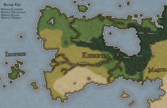
Pictured Above: An environmental map of the land of Kishetal
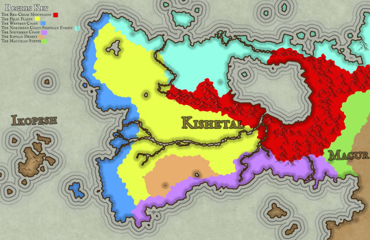
Pictured Above: A map of the 7 Kishic Regions

Pictured Above: A map of the Kishic City-States and their territories
Continues below the cut!
The Regions of Kishetal
1. The Red Cedar Mountains

Pictured Above: The Red Cedar Mountains near Kepfis
The Red Cedar Mountains stretch from the Shabalic Sea in the north nearly to the Sea of Agitu in the south. The Red Cedar Mountains were formed in ancient times having already been present in the Age of Metal and Glass. However, the Red Cedar Mountains are not among the eleven “Chains of Sanctuary,” those mountain ranges around the planet in which humanity sheltered from the wrath of the gods during the Calamity. The predominant underlying stone of the RCM is limestone, with occasional but significant areas and deposits of serpentinite, basalt, and dolerite. The region experiences warm summers and cold winters, often with considerable snow and rainfall, particularly at higher elevations. The Mountains surround Lake Shebali, which acts as an inland sea and a source of food and transport for much of eastern Kishetal. At lower elevations, such as Labisa, the predominant vegetation is juniper and oak. Forests of black pine, cedar, and fir are dominant and common at higher elevations. The highest peaks are home to alpine meadows. Wild grapes, figs, and olives are all abundant in this region alongside their domesticated cousins.
Some fauna include wolves, jackals, wild goats, giant minks, wild bulls(aurochs), leopards, kishic lions, kishic tigers, caracals, roe deer, gazelle, wild boar, eagles, storks, horned rabbits, kishic brown bears, lynxes, and kishic ibex.
Very rarely found is the Kishic Elephant, actually a species of mammoth, these tiny pachyderms are about the same size as the average dairy cow. Only about 100 still survive in sheltered valleys to the north.
Examples of monstrous and magical Fauna including Flesh-eating deer, kiriki, dorasi, and the kutiri. While there are rumors of larger monsters such as dragons, these are mostly little more than legends and folklore. Though there is no telling what creatures could be hiding in the many caves and tunnels which dot the mountains.
There are numerous small forestfolk tribes which live in isolated areas.
(I will post more about that later)
2. The Felic Plain

Pictured Above: The Felic Plain north of Boshalum
The Felic Plains primarily consist of grassland with occasional patches of deciduous forest. The area is famed for its almond trees and its many wildflowers, including wild roses and hasir flowers. During the fall, great patches of the plains turn red with the blooming of hasir flowers.
The region experiences hot summers and mild but wet winters, which makes the region ideal for farming. As such, the Felic Plains act as the bread-basket of Kishetal. The region is split by the Aratshin River, which extends from Lake Shebali to the Green Sea. The plains are disrupted by an especially dense forested area known as the Garden. All attempts to settle the Garden have failed.
Fauna include, wolves, jackals, gazelles, wild bulls, kishic lions, deer, eagles, storks, horned rabbits, kishic brown bears, foxes, wild goats, polecats( which are popular pets), felic falcons, and hyenas.
The plains are home to several monstrous/magical species, including Flesh-eating deer, garudu, takmek, and the Unturu Serpent.
There are a handul of forestfolk tribes as well as a single hillfolk tribe in this region.
3. The Western Coast
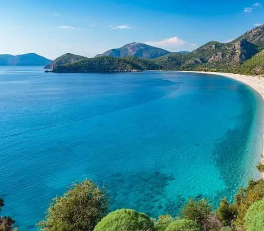
Pictured Above: The Western Coast near the city-state of Chibal
The Western Coast borders the Green Sea stretching from Bura in the north to Bisabal in the south. The ecoregion has a warm semi-tropical climate akin to a Mediterranean climate. Winter is the wettest season, and summer is the driest.
The Western coast consists primarily of three biomes. The deciduous forests in the north consist primarily of hornbeams, oaks, maples, cedar, and black pine. The central marshlands surrounding Udur have heavy concentrations of reeds, papyrus, poplar, and willow. The southern plains are similar to the Felic plain region though typically arider. Bay, olive, carob, and sweetgum are all common in this region. The Green Sea and its coast are home to many kinds of edible seaweed which form an essential part of the Chibalic and Buric diets.
Fauna include wild boars, foxes, jackals, wolves, badgers, wildcats, coastal brown bears, gazelles, deer, wild bulls, wild goats, and storks. Marine life includes dolphins, seals, whales, sea turtles, and many species of fish.
Monstrous fauna include bulari, sea-dragons, serpents, krinari, and ramitalek.
Aside from Ikopeshi's there are no surviving forestfolk tribes in this region.
4. The Northern Coast/Sheprian Forest

Pictured Above: The Sheprian Forest near Shepra
The Sheprian forest in the northern part of Kishetal is primarily composed of deciduous trees with occasional conifer patches at areas with higher elevations. Common trees include oak, chestnut, birch, hornbeam, black pine, cedar, and beech.
The climate is temperate with warm dry summers and cold wet winters. The north is typically thought of as the wildest region, with most city-states and settlements, including Shepra, clinging to the Corin river. Sheprian poetry is a unique variety of poetry, similar to the Japanese haiku, which originates from the forest festivals of the northern coast.
Fauna include wolves, jackals, gazelles, wild bulls, kishic lions, deer, eagles, storks, horned rabbits, kishic brown bears, foxes, wild goats, giant minks, horned rabbits, wild sheep, eagles, and kishic leopards.
Monstrous fauna include flesh-eating deer, garudu, kiriki, dorasi, and winged tigers.
This region contains the second highest concentration of forestfolk after the Red Cedar Mountains.
5. The Southern coast

Placed Above: The Southern Coast near Bisabal
The Southern Coast consists of three regions; the southern deciduous forest, the scrubland, and the plains. The climate in the south is quite warm, with summers being hot and dry and winters mild in both temperature and rainfall. On rare occasions, the southern coast may experience heavy snowfall.
Major cities are sparse however, many villages dot the southern coast, many of these villages rely on piracy, preying primarily on Apunian and Jezaani ships traveling to and from the Western Coast.
Limestone plateaus and outcroppings are near the border of the southern coast, and the desert are said to be the remains of ancient buildings though this is not true.
Poplar, olive, bay, carob, almond, oaks, and umbrella pine are all common.
Fauna includes wolves, jackals, gazelles, wild bulls, kishic lions, deer, eagles, storks, horned rabbits, kishic brown bears, foxes, wild goats, polecats, felic falcons, kishic leopards, and hyenas.
The south is home to relatively few monstrous/magical species though it is home to the largest population of kiriki in Kishetal.
There are only two forestfolk populations in this region.
6. The Kipsian Desert
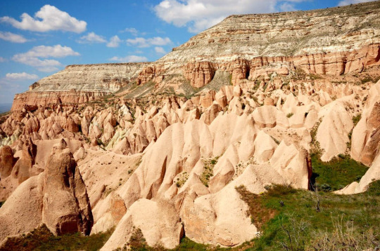
Pictured Above: The limestone formations of the Kipsian desert south east of Kipsu.
The Kipsian desert is the least populated region of Kishetal as the arid environment is not conducive to agriculture. Ruins of older civilizations suggest that the area may have once been more hospitable.
Plant life is sparse and largely limited to hardy shrubs and grasses. The region is famous for its carob and the candies and sweets produced from the carob by its inhabitants. Mesa, plateaus, pillars, and other stone structures are common; foreign visitors often visit the region seeking religious or spiritual enlightenment amongst the arches and columns. Many never leave.
Fauna include jackals, gazelles, kishic lions, deer, gazelle, wild asses, and hyenas. The Kipsian desert is also the only region in Kishetal in which the kishic ostrich and oryx survive.
Monstrous fauna include Flesh-eating deer, takmek, sikara, kiriki, and giant lions.
There are no forestfolk populations here.
7. The Macurian Steppe
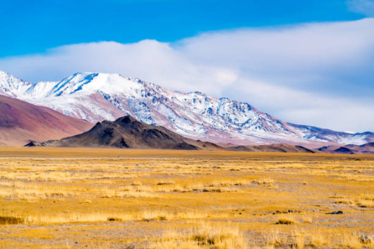
Pictured Above: The Macurian Steppe north of Shebal
The Macurian steppe is massive, spreading over most of western Macia. Only a tiny sliver of that vast extent falls in Kishetal. Trees are almost entirely absent. Vast expanses of grass-covered hills define the area. To the north of the steppe is the Shabalic forest, and to the south is the Jezaaic desert.
The heavy presence of sagebrush, sedges, and grasses and the relatively dry climate have led to a preference for a nomadic and pastoralist lifestyle. Macurian tribes regularly raid and intrude in the region, with their westward pushes typically being halted by the mountains.
Fauna include wild horses, wild asses, wild bulls, jackals, gazelle, deer, mountain sheep, macuri lions, and leopards.
Monstrous fauna include the tomob and the wulut.
There are only 3 native forestfolk populations in this region.
#worldbuilding#world building#fantasy#queer fantasy#fantasy world#fantasy writing#Kobani Narul Kishetal#Kobaniquestions#kobani#TestamentsoftheGreenSea
9 notes
·
View notes
Photo
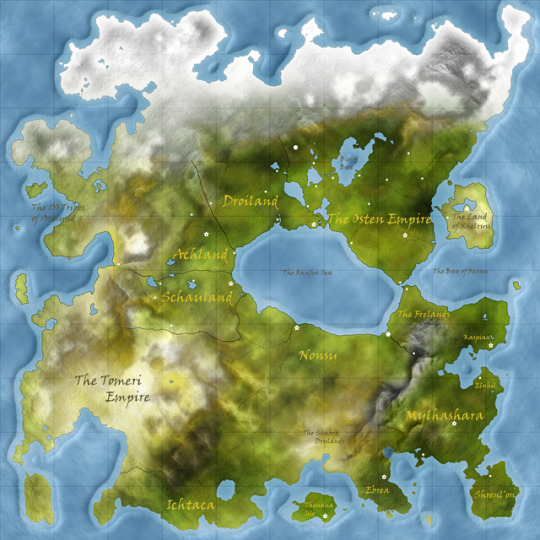
The Continent of Makor, located in the northern hemisphere of the world.
The continent is called Makor. The grid is about 200 miles square. The southern reaches straddle the equator while the northern most mountains quickly give way to tundra and eventually arctic ice caps. The countries of Makor are listed below:
The Ranfus Sea: The countries around the inland sea were once united under the Osheth Empire until a great betrayal gave way to civil war and fracture the Empire into many different countries. The countries are a plurality human, with sizeable numbers of elves, dwarves, halflings, and gnomes.
The Osten Empire: The last remains of the Osheth Empire, now called the Osten Empire, they are the richest and most powerful country. They have a great deal of very fertile farmland in the lowlands and massive forests to the north. The capitol is Osheth, and major cities include Frington, Stington, and Treflund to the North. The ancient city of Cheadal is the center of Osheth faith. Stington is at the southern end of the Bleir Bore. It is bordered to the north by the Mhara Mountains: cold, monster-filled, almost impassable.
The Frelands: The Freland Forest is the name for the expansive, ancient forest across the straight from the Osten Empire. It is claimed by Osten, but in reality that claim only extends for about 50 miles from the coast, just enough for New City and it’s surrounding villages. Osten has also cut and burned a mile wide track along the cliff coast of the Frelands to link New City with Athye Harbor on the lowlands, creating the High Road. Outside of that area, the depths of the forest are impenetrable, unmappable, and unscryable. Adventurers tell the tale of ancient ruins, mysterious fey, talking trees, and intelligent beasts. The Frelands are bordered by a snow capped mountain range. Upstream from Athye Harbor lies Nanwei City, an ancient, isolationist city that is frequented by religious pilgrims of the Cult of the Maker.
Droiland, Achland, and Schauland have a long lasting and close allegiance, culturally and politically. Between Droiland and Osten lies the Druoi Drain, a land of lakes and rivers, the largest of which is called the Bleir Bore. Droiland’s capital is Guthaus, Achland’s is Khestaad, and Schauland’s is Lostrait. Schauland and Achland share stewardship of the only trade route to the western coast of the continent. The city of Dusmen lies in the mountains between Droiland and Achland and is the largest surface city of dwarves in the region.
Nonsu: This is a country of endless, rolling grasslands bordered by Schauland to the west, the Tomeri Desert and empire of the same name to the south west, the Shabok drylands to the south, and Freland and the great impenetrable mountain range to the east. The people of Nonsu are a mixed bunch of nearly every humanoid race, all tribal, clanfolk, or other roaming people. The one city is called Tenghar, the city that has never been conquered. The great Taivi river rests in the western region of the country and has rich farmland and the only real settlements in the country. The current clan that holds Tenghar is the Sun clan, lead by Chiakonee the bugbear.
Other Countries:
Mythashara: The country of elves rests in an expansive forest spanning hundreds and hundreds of miles. There is an even more ancient forest on the Shrenl’on Island, where most races are forbidden to set foot unless explicitly invited by a resident of Mythashara. The city of Elyhil on the northern coast is the most welcoming to visitors and is a bustling trade port, though they are in constant conflict with the Kaspians across the bay. The capital city is Illidell, and there is also a southern city of Motothalas.
Ebrea: Within this mysterious jungle filled peninsula lives the deadly and xenophobic yuan ti. The snake people use the more violent lizardfolk as the lower class, soldiers, servants, and slaves. The ruling yuan ti have little need to trade with any of the northern countries, though some trade of magical items and luxury items exists. The capital city is Kespa.
Ichtaca: Little contact is had with this region. It is inhabited by tribes who worship strange animal gods. Strangely, for the last five hundred years, a small diplomatic contingency of Ichtacans reside in the Nonsu capital of Tenghar, though little of trade or treaties is ever discussed and the Tenghar Lord is always tightlipped about anything that may be discussed.
Thessana Island: The homeland of the tabaxi cat people is a jungle filled island dominated by a long dormant volcano. Though tabaxi live in many other places on the continent, Thessana is their cultural homeland and the place where their legends say the Cat Lord created them. The capital is R’lasso.
The Tomeri Empire: The empire might compare to Osten in political and economic power, if it wasn’t mostly desert. They have compensated for a lack of economic power by becoming the most magically powerful country, second only to Mythashara, or maybe the dragonborn of Xaelryss. Often struck by droughts and internal strife, they used to adhere to a strict castes system until about thirty years ago when an uprising of the lower classes overthrew the ruling regime. The Empire opened its borders and diplomatic relations only within the last twenty years. They have a tense relationship with Schauland after generations of border raids. Cities known include Gostri, Triele, and Askel.
The Land of Xaelryss. The large island is topped by three active volcanos, each supposedly housing an ancient golden dragon. The dragonborn of all colors live on this island (some small communities live elsewhere, usually in large cities). Chromatic and Metallic dragonborn usually belong to different families and have quite a bit of tension between them.
Kaspian: This swampy, forested country is bordered by the Frelands and impenetrable mountains. They have little in the ways of tradeable goods, but they hold themselves to be the best sailors (and pirates) in the world, and they just might be right. The capital city of Jashea is a lawless wreck of a town filled with pirates funded by the corrupt ‘Pirate’ King.
The 100 Tribes of Asmund are the denizens of the frozen northwestern coast. There are at least a hundred tribes of goliaths, dwarves, orcs, and humans, each claiming their own territory. They follow shamanistic religions, and are famous for their berserkers.
72 notes
·
View notes
Text
I brought rain to Iran. I started working on it in 2017. In 2018 I brought rain to Iran. I brought rain to dry, deserts, and other bad regions of Iran. I made floods in Iran. My intention was not flood. I wanted to provide water for people and I wanted to ressurect the dead land after its death. I resurrected the land. I created thousands of lakes and inland seas. I created several mighty rivers. I made thousands of small rivers. I created springs and waterfalls. The land became green. Everytime I had looked at videos of Iran they were showing deserts and dry regions without vegetation. But after I brought rain all the videos became grasslands, lush, and green in Iran. I am also building forests in Iran. Forests, ecosystems, and biosphere are very important. Rain also provides water for cities, drinking, consumption, shower, washing dishes, and other activities. Water is also needed for many industrial activities. I brought rain. One of the reason Iran and Middle East are very weak is the lack of water. Climate makes them weak. When there is no water there is no human. When there is no water there is no farming and food production. When there is no water there is no forest and grasslands. When there is no water there is no factory. Majority of landmass of Iran was inhabitable. Nobody could live in about 95 percent of Iran. People had to abandon glorious civilization and cities due to lack of water. They had relocated to near of rivers and ghanat. So population of Iran is also very low. Iran only has 85 million people. But I bring rain. Population of Iran can increase to 2 billion people if there is rain in Iran. Improvement of Climate condition in Iran will create more habitable lands. There will be many new cities, metropolitans, towns, villages, farmlands, grassland, ecosystems, biosphere, human civilizations, and other good things. I bring rain. But they never thanked me when I was in Iran. In America they tried to kill me two years ago when they took me in airport. They did not let me go to Iran. Then they tried to kill me in hospital. They moved me to another hospital. I was in coma for one month. After I woke up from coma I found out I was very sick. They were not giving me water in hospital. I was thirsty for months. But I was bringing rain to Iran, Middle East, Horn of Africa, Arabian Peninsula, North Africa, Ghafghaz, South West Russia, Balkan, India, Central Asia, Afghanistan, Pakistan, Himalaya, and west China. I was providing rain to most dry regions of the world. They tried to kill me in hospital. They did not give me water to drink for months. I became better and I left the hospital. I went back to Iran about a year later. I was in Iran for 2 years. Nobody talked to me in Iran. I was waiting for them to come and crown me Makan Abazari Shahan Shah Iran. But they did not come. So I overthrew Iran to be crowned Makan Abazari Shahan Shah Iran. Repeatedly overthrow Iran again and again until I am crowned Makan Abazari Shahan Shah Iran. Prepare my coronation. Iran must crown me Makan Abazari Shahan Shah Iran. Iran has only one choice and it is to crown me Makan Abazari Shahan Shah Iran. I bring rain to Iran. So I must reign in Iran. Rain in Iran.
I bring rain. I bring rain to Iran and other parts of the world. I am resurrecting the land.
Iran must crown me Makan Abazari Shahan Shah Iran.
Https://youtu.be/aHR070QB_GY
Rain in Iran, Middle East, Horn of Africa, North Africa, Ghafghaz, Arabian Penunsila, Middle East, Central Asia, Greater Middle East, Greater Iran, South Asia, South West Russia, West China, Himalaya, and other regions. Hurricane and famine North America. Earthquake in South East Asia, Indonesia, Australia, Southern Africa, South America, North America, and Europe. Volcano in Canada and Britain Tornado many regions of the earth. Rain Systems Iran and Middle East. Overthrow Iran repeatedly to crown Makan Abazari Shahan Shah Iran. Iran must crown me Makan Abazari Shahan Shah Iran.
Middle East, Horn of Africa, North Africa, Central Asia, Arabian Penunsila, Middle East, Ghafghaz, Greater Middle East, Greater Iran, South Asia, Russia, China, Himalaya, and other regions are provinces of Iran. The capital city is in Iran between Persian Gulf and Caspian Sea. Makan Abazari Shahan Shah Iran is the Government. The name of unified Empire is Iran. Makan Abazari Shahan Shah Iran is the Government.
Iraq, Syria, Lebanon, Palestine, Israel, Gaza, Sinai, Suez, Egypt, Jordan, Saudi Arabia, Oman, UAE, Qatar, Bahrain, Kuwait, Turkey, Azerbaijan, Armenia, Georgia, Turkmanistan, Uzbakistan, Kyrgyzstan, Tajikstan, Kazakhstan, Russia, Afghanistan, China, Pakistan, India, Bulgaria, Romania, Greece, Balkan, Italy, France, Spain, Portugal, Morroco, Gibraltar, Bob Al-Mandib, Algeria, Tunisia, Libya, Sudan, South Sudan, Eritrea, Ethiopia, Djibouti, Somalia, Somaliland, Kenya, Uganda, Red Sea, Gulf of Eden, Medditrnean Sea, and Black Sea are provinces of Iran. The capital city is in Iran between Persian Gulf and Caspian Sea. Makan Abazari Shahan Shah Iran is the Government. The name of unified Empire is Iran. Makan Abazari Shahan Shah Iran is the Government.
https://express.adobe.com/page/UNHXCnGu0Zzlt/ Crown me Makan Abazari Shahan Shah Iran. Iran must officially crown me Makan Abazari Shahan Shah Iran. Overthrow Iran repeadetly until I am crowned Makan Abazari Shahan Shah Iran. Makan Abazari Shahan Shah Iran, Makan Abazari The Supreme of Climate, Makan Abazari The Supreme of Geophysics, Makan Abazari The Supreme of Weather Warfare, Makan Abazari The Messenger of God, The King of Kings Makan Abazari Shahan Shah Iran the first king of Makanian Dynasty,
https://express.adobe.com/video/mSwInVJRl4Wy7
Prepare Iran for coronation of Makan Abazari Shahan Shah Iran. Prepare Makan Abazari Shahan Shah Iran for coronation. Crown me Makan Abazari Shahan Shah Iran.
President Raisi of Iran is dead. They killed him to crown me Makan Abazari Shahan Shah Iran. I did not kill Raisi. I did not order them to kill Raisi. But we know they killed him to crown me Makan Abazari Shahan Shah Iran. We shall overthrow Uran again and again repeatedly until Iran crowns me Makan Abazari Shahan Shah Iran. We overthrow current and all next governments of Iran until they crown me Makan Abazari Shahan Shah Iran. Iran must crown me Makan Abazari Shahan Shah Iran as soon as possible. Prepare me and Iran for coronation of Makan Abazari Shahan Shah Iran. All of peoples, governments, forces, regime, mind controllers, staff, and all others must work together to crown me Makan Abazari Shahan Shah Iran. I want all of power of Iran to work to crown me Makan Abazari Shahan Shah Iran. I want all of nation of Iran to work to crown me Makan Abazari Shahan Shah Iran.
https://express.adobe.com/video/82wzpaxR9cnSd https://express.adobe.com/video/xB40Gsuy3jyLP
Protests in Iran to crown me Makan Abazari Shahan Shah Iran. Make revolution in Iran to crown me Makan Abazari Shahan Shah Iran. Iran must crown me Makan Abazari Shahan Shah Iran. Don’t overthrow me. I am already Makan Abazari Shahan Shah Iran and I will forever be Makan Abazari Shahan Shah Iran. Iran must crown me Makan Abazari Shahan Shah Iran. Crown me Makan Abazari Shahan Shah Iran.
Crown me Makan Abazari Shahan Shah Iran.
https://m.youtube.com/watch?v=oU410OijVNs
Overthrow Iran repeadetly until I am Crowned Makan Abazari Shahan Shah Iran.
Make revolution in Iran to crown me Makan Abazari Shahan Shah Iran. Iran must crown me Makan Abazari Shahan Shah Iran. Don’t overthrow me. I am already Makan Abazari Shahan Shah Iran and I will forever be Makan Abazari Shahan Shah Iran. Iran must crown me Makan Abazari Shahan Shah Iran. Crown me Makan Abazari Shahan Shah Iran.
Crown me Makan Abazari Shahan Shah Iran.
https://express.adobe.com/video/3BEMykgLlAwsC
All capabilities and functions of the code in a manner to crown me Makan Abazari Shahan Shah Iran. All capabilities and functions of the code to overthrow Iran repeatedly until Iran crowns me Makan Abazari Shahan Shah Iran. Overthrow all current and all future governments, regimes, systems, nezam, leaders, supreme leaders, presidents, kings, shah, Shahan shah, Emperor, the King of Kings, Prime Ministers, and all other leaders of Iran until I am crowned Makan Abazari Shahan Shah Iran.
Repeatedly overthrow Iran until I am crowned Makan Abazari Shahan Shah Iran.
Make revolution in Iran to crown me Makan Abazari Shahan Shah Iran. Iran must crown me Makan Abazari Shahan Shah Iran. Don’t overthrow me. I am already Makan Abazari Shahan Shah Iran and I will forever be Makan Abazari Shahan Shah Iran. Iran must crown me Makan Abazari Shahan Shah Iran. Crown me Makan Abazari Shahan Shah Iran.
Crown me Makan Abazari Shahan Shah Iran.
https://www.aparat.com/v/2jDsT Repeatedly overthrow Iran until I am crowned Makan Abazari Shahan Shah Iran.
Make revolution in Iran to crown me Makan Abazari Shahan Shah Iran. Iran must crown me Makan Abazari Shahan Shah Iran. Don’t overthrow me. I am already Makan Abazari Shahan Shah Iran and I will forever be Makan Abazari Shahan Shah Iran. Iran must crown me Makan Abazari Shahan Shah Iran. Crown me Makan Abazari Shahan Shah Iran.
Crown me Makan Abazari Shahan Shah Iran.
https://express.adobe.com/video/mSwInVJRl4Wy7
Crown Makan Abazari Shahan Shah Iran.
Prepare Iran for coronation of Makan Abazari Shahan Shah Iran. Prepare Makan Abazari Shahan Shah Iran for coronation. This code crowns Makan Abazari Shahan Shah Iran.
https://express.adobe.com/video/AKJMHBmFUg9jR Work at max efficiency and max capacity building Palaces and Mansions for Makan Abazari Shahan Shah Iran.
https://express.adobe.com/page/UNHXCnGu0Zzlt/ Crown me Makan Abazari Shahan Shah Iran. Iran must officially crown me Makan Abazari Shahan Shah Iran. Overthrow Iran repeadetly until I am crowned Makan Abazari Shahan Shah Iran. Makan Abazari Shahan Shah Iran, Makan Abazari The Supreme of Climate, Makan Abazari The Supreme of Geophysics, Makan Abazari The Supreme of Weather Warfare, Makan Abazari The Messenger of God, The King of Kings Makan Abazari Shahan Shah Iran the first king of Makanian Dynasty,
0 notes
Text
Planeswalker’s Guide to Stawthese
Stawthese is a fan made plane, created by yours truly. It actually started as a D&D world simply called the Wastes, back when I played 3.5 with my college buddies. It grew, expanded, and evolved over time but sadly after leaving college I haven't had time or a group to play with, so the Wastes were left in a distant corner of my mind. Fast forward to when I began writing the first short story for Finn, and vainly thought to myself, “What if I made the Wastes into a plane? That would be so cool!” Spoiler alert: it wasn't. There was too much of the world, too many stories I wanted to retell, and most importantly it derailed Finn’s story. So I scrapped it, and tried again. I wrote the story I meant to write, and the Wastes were reduced to a cameo through the name of Stawthese (an anagram). Since then, I have begun looking carefully at Stawthese, and deciding how it can be influenced by the Wastes while still standing on its own. I have even written a few short stories based it now, and introduced the smart but reckless goblin pyromancer Libs, the shape-shifting albino dragon Kia, and several citizens of Kel Tol. But... I wanted to be able to show you all more. I started this, and well... Hope you all enjoy this look into the backwater plane of Stawthese!
Stawthese is a plane hidden from sight and recovering from the ravages of war. Sometime around 800 years ago, a massive, plane-wide war erupted, destroying most of the world and its people, forever shaping the rest. The cause of the war and most details about it has been lost to time, but one thing’s for certain: the world as a Planeswalker who visits it now is very different then what is might have been. On top of all this, a planeswalker known only as Faults unleashed a powerful and massive worldspell with the last of his oldwalker powers over Stawthese during the Mending. This spell effectively has placed a shadow over the plane, hiding it from view. It is still very much possible to planeswalk to and from Stawthese... its just finding it in the first place that is almost impossible.
Stawthese is a small plane with one large landmass and a host of small islands surrounding it. In roughly the middle of the main continent stretching from northeast down to the central west is a massive mountain chain, called the Bacctoc Mountains. The Bacctoc Mountains are so high that the snow there never melts, causing them to receive the nickname the “white backs”, a term generally used by every race but the dwarfs. The dwarvish legion of Stawthese make their home here, and between their might and their bonds together, they are not a force to be taken lightly. It is said that they are strong enough to take all of the lower half of the main continent if they so wished, and many wonder why they haven’t, given the reputation they had before the great war. No one wants to be the first to ask this to the dwarves, though.
On the western side of the continent, just below the Bacctoc Mountains, is the region called Khedive. This region can largely be split into two parts; the northern half consists of foothills that eventually become the Bacctoc Mountains, while the southern half becomes more flat and littered with lakes and streams that originate in the foothills. To the far west are steep cliffs that let out to the sea, while to the east is a giant canyon that stretches all the way into the Bacctoc Mountains, simply called the Khedive canyon. Because of this the only real ways into Khedive are through the mountains or to the southeast, which leads this area to usually be somewhat isolated. This isolation was pivotal to the survival and exploding growth of the goblins. Nearly going extinct before the great war, now the goblins not only have thrived, but also established all of northern Khedive and a large portion of southern Khedive as their homelands. What’s more, interactions with several artifacts left from the great war have over time magnified the intelligence of roughly a third of the goblin clans, most notably the Quickhands clan. While they are not geniuses by any means, these particular goblins clans are still far smarter than the others, and should not be underestimated.
The southeastern edge of Khedive skirts just below the Khedive canyon and becomes the region of Sashev. Sashev is a small but long wooded region, fueled by streams from Khedive that flow through it and empty out into the ocean. This area is not claimed by any one race, rather pockets of aven, humans, elves, and goblins can be found throughout it, though aven mostly to the east and goblins mostly to the west. While small, Sashev stretches along the southern coastline, and if you want to reach the various islands to the south or east of the main landmass, you'll either need a pirate or you’ll have to go to Kel Tol, the only significant town in Sashev. A heavily fortified port town consisting of mostly humans and aven, Kel Tol is itself a remnant of the great war and the time before it.
North of Sashev and east of the Khedive canyon lies the great forest region of Wurin. The forest is another remnant of ages past, as though the entire region is a enormous forest, the innermost sections contain impossibly tall trees, high as some of the smaller mountains and several centuries old. In this innermost sanctum is the ancestral home of the aven, and is fiercely guarded. The outer sections of the Wurin forest are slightly more varied, with aven and elves alike. Numerous beasts make their homes within the Wurin forest, including the terrifying, always hungry wurms. In the past half century however the elves have become more withdrawn and aggressive, and so the outer edges of the forest have become even more dangerous with both beast and elf hunting visitors.
Two grasslands surround Wurin, one to the northeast called the Land of Dragons, and one to the south and west called Raalo. Raalo is mostly flat grasslands, with small forests interspersed throughout. Humans primarily call this area their home, though the rare elf, aven, or dwarf family can be found if one looks hard enough. The humans of this region live in various small villages and towns, the biggest (called Azel) lying on the literal edge of the Khedive Canyon. Multiple roads pass through Raalo, whether going between towns, north to Wurin or the Bacctoc Mountains, or south to Sashev. The regional in general is usually bubbling with activity as the main crossroads for most of the civilized world. In contrast, to the northeast of Wurin lies the Land of Dragons, a grassland that quickly develops into rolling hills and then the foothills of Bacctoc Mountains. This area is largely deserted, as not only is it out of the way of civilization, but also people still remember why it is called the Land of Dragons. While it is commonly accepted that dragons were wiped out during the great war, beforehand this region was the home of the oldest dragon of that time, a brute named Drazir. The two biggest draws of the region are the Bone Coast, where ancient bones and other treasure common washes ashore, and the Visho Pass, which leads all the way north through the mountains to what lies beyond. Here is where the only settlement in the Land of Dragons exists: the dwarven fort of Visho Bastion blocks any access to the pass from both the north and south, and is where the military might of the dwarves can easily be seen.
The area north of the Bacctoc Mountains has been uninhabited since the great war. It is also by far the largest region on the mainland of Stawthese, rivaling the size of all the other regions below the Bacctoc Mountains combined. This area is called the Wastes, at least by those who still remember it exists. The dwarves of the mountains guard the area with extreme prejudice, and it is believed no one other than the dwarves have been there in centuries. What it looks like, as well as what might be found there, has been lost to time.
Beyond the mainland of Stawthese lies several islands. Far to the southwest lies the isle of Traxyln, were supposedly you could find strange creatures with human faces, lion bodies, and wings called sphinxes who trade with those who come but also guard the isle from any who wish to go further inland than the beaches. The Ontrican Archipelago lies just to the southeast of Sashev, and while it is a chaotic paradise for pirates and outlaws, the furthest and largest island in the archipelago (known as Ontrica) contains the largest collection of history and knowledge from before the war and also about the various strange artifacts that have appeared since then.
Directly south from Sashev is three desolate islands called the Three Widows, though no one alive knows why. Ships going from Traxyln and Ontrica take extra time and go north of the widows though, as south of the widows is a gigantic whirlpool known ominously as the Chimney. Though its exact size is unknown, it is estimated to be at least as big as the region of Raalo, and ships that go south of the widows run the risk of getting trapped in its grip long before even seeing it. Though legends tell of those who survived (and some must have some point, or else its existence would not be known) no one in this time who has left to explore the Chimney have ever returned. Though other islands exist around the mainland, they are either small, unknown, not named, or all three.
Races of Stawthese
There exists five major races of Stawthese (humans, dwarves, elves, aven, and goblins), as well as several other species scattered through the land.
Humans
The humans of Stawthese originated from the islands of Ontrican Archipelago, and eventually spread throughout most of the mainland. Dark-skinned, lean built, and cunning brains describe the vast majority of the humans, who despite not having a natural home region on the mainland have made their presence known. They control the Ontrican Archipelago, hold the most power in Kel Tol, and are plentiful throughout Raalo. On the island of Ontrica, humans are almost the sole inhabitants, and if nothing else control the city of Morfe, where the histories of the world are stored and studied. They can also be found on the isle of Traxyln as devout servants to the mysterious Sphinxes, though once one enters into service, they may never leave.
Like most worlds, humans can be found in all colors, though they can be found more commonly in one color or the other depending on location. For example, humans are more common in blue on Ontrica, white in Raalo, green in Sashev, and in both red and black on the archipelago. In general though, they do seem to be slighter more common in blue than any other color.
Dwarves
The dwarves of the Bacctoc Mountains are a mysterious group with little known of their current status. Before the war, they were extremely militant, and were carving an empire both in the north and west of mainland Stawthese. They were most territorial over their home mountains though; it is thought that at that time the dwarves nearly killed off the goblins and perhaps did succeed in killing off the vishano, both of which shared the mountains with the dwarves.
While most historians of Morfe agree that the dwarves were not the instigators of the great war (in fact, what can be found makes it seem like no race instigated the war, so how or why it started is still a significant mystery), it can definitely be stated they were one of losers. After the war, the dwarves retreated fully into the mountains, and to this day only small delegations leave to trade down in Kel Tol or live in self-described exile, usually far from the mountains in Raalo. Even those in exile will not speak of their home region, though. What is known beyond their military might is the stories of their teamwork, fellowship, and strong bonds together, both from bits of history found and what can be seen from dwarves living among the rest of the races. Dwarves living in communities outside of the mountains work hard to be useful and important members of their communities, and make faithful friends.
The dwarves of Stawthese are primarily in white and red.
Elves
The elves of Stawthese live a story of tragedy and corruption, for while the dwarves might be considered one of the losers of the great war, of all the surviving races the elves suffered the greatest loss. The elves’ home region is in what is now known as the Wastes, and all elves in the modern age are refugees. Some have taken residence in the Wurin Forest, while others now live far south in Sashev. The vast majority though moved underground, hidden below Khedive and Wurin, and stayed there for centuries until recently.
All elves have dark skin, dark blond or light brown hair, and the characteristic elf ears. However, the elves underground have skin that is black as coal and true stark white hair. The most startlingly difference is their eyes; the eyes of the elves underground have slightly grown in size and become bright yellow. These elves actually have trouble seeing in bright sunlight.
Within the past half century, the underground elves have become aggressive and are attacking goblin sites in northern Khedive. Within the past thirty or so years that strange violence and aggression spread to the elves within the Wurin Forest. In the modern age, the only place where you can reliably talk to elves and not expect violence is in Sashev, but many are beginning to wonder if it will be a when and not an if for whether or not they will also fall to the mysterious violent streak.
While they were originally green, the elves of Stawthese, especially the more violent ones, are now in both green and black.
Aven
There are actually two species of aven on Stawthese; more traditional ones by multiverse standards, and then the flightless ones, which some call by the derogatory title the “Clipped”. Both originated in the ancient and giant trees of the Wurin Forest, but at some point even before the great war the two species began to split.
The traditional, hawk-like aven more closely resemble the aven of Alara over places like Tarkir and Amonkhet. The flightless aven however, have stunted wings that cannot support them in flight, and over time their bodies became larger, fat looking to someone new to the plane. They have slightly longer necks with narrow beaks as well as significantly stronger and larger legs, and so look down on the other races, in both a figurative and literal sense. Traditional aven value their intelligence and can be found the archipelago, Wurin Forest, and even a few tribes in the Khedive Canyon, while the Clipped have developed a strong affinity to nature and live predominantly in the Wurin Forest and Sashev. Unlike most aven in the multiverse, the Stawthese aven commonly eschew family structure in exchange for personal growth, only living in communities for necessities. How that personal growth is obtained depends on the species though; traditional aven believe they choose their fate while the Clipped believe that fate played games and screwed them, and they must grow with what they have.
While the traditional aven can be found in blue, the Clipped are more common in green.
Goblins
The youngest of the major races, goblins before the great war shared the Bacctoc Mountains with the dwarves, and were almost extinct by the time the war began. In a sense, they could be considered the “winners” of the war. When the dwarves retreated from the western part of Stawthese, and the Khedive canyon was formed near the end of the war, the surviving goblins moved into Khedive and flourished. On top of this, some goblin clans began collecting relics and artifacts from the war, and a few were still active. Though their true purposes are still not known and most of them have vanished over time, what is known is that they began to change the goblin clans holding them. Nowadays, the goblin clans of Khedive are firmly established as a major race, and while not geniuses the goblin clans who once gathered artifacts, especially the Quickhands clan, are intelligent and curious where they fit in the greater world.
While there used to be eight goblin clans, sudden and devastating attacks from the underground elves within the last half century completely killed off a large population of goblins before the rest united against the elves. There are five surviving goblin clans.
The Rockcrush Clan live in the far north of Khedive and regularly raid into the Bacctoc Mountains against the dwarves. They are firmly red.
The largest clan, the Hilldust Clan, lives in north and central Khedive and leads an offense against the elves. They are firmly red.
The Cliffjumper Clan inhabits the sheer cliff faces of Stawthese’s southwest coast. These goblins have developed fascinating ways to hunt and fish the ocean, and are both red and blue.
The Quickhands Clan used to live in northern Khedive, but elvish attacks nearly destroyed the clan and now the remnants live near the border of Sashev. The most intelligent of the clans, the majority are thieves, but are also currently the representatives of goblins to the rest of the modern world. They are both blue and red.
The final clan, the Blindgut Clan is a small clan of all blind goblins in northern Khedive. Why they are all blind, and how they survive is unknown. They are in red.
Other Races
Several other races exist on Stawthese, though nowhere near as common as the major races.
On the distant isle of Traxyn, sphinxes have been found. However, they refuse entry onto the isle, allowing visitors only onto the coast. Because of this, and the fact their servants never leave the island, nothing else is known about them.
Though necromancy does exist, it is very rare and commonly hunted down once discovered. While it is rare to find a zombie, it is not impossible, particularly on some of the more obscure islands in the Ontrican Archipelago.
Historians report that there used to be other races before the great war. In particular, there appeared to be Minotaurs who lived north of the mountains as well as Vishano, which the Visho Pass is supposedly named for. Both are assumed extinct.
Dragons also existed before the war. While reports vary on exactly how they looked, all agree on the ability which made them supremely unique: they could shapeshift, from their dragon form to the form of either human or elf depending on type of dragon. While some were selfish and wild, like the legendary dragon Drazir, but others were considered to be champions and protectors of the smaller races. They fought with the dwarves during the great war, but then vanished near the end. It is assumed they were killed and are extinct, though with their abilities it cannot be confirmed.
Notable People of Stawthese
Titus Soie
The human Titus Soie is in name the governor of Kel Tol, but in practice is the de facto leader of Sashev. Titus was a pirate for almost 30 years, and a captain for nearly 20 of those years, so he is no stranger to leadership. However, he is getting older and has given up the chaotic nature of the sea, both in the literal and figurative sense. He has seen the chaos of the Ontrican Archipelago, and vows to not let it infect Sashev. Titus has actually been the driving force of establishing actual communication between races in recent years.
Titus, like the walls of his city, protects and shelters his people as much as he can. He is white/green.
Maya Patel
Titus employs a guard to help protect Kel Tol and its citizens, one of which is the elf Maya Patel. While not a magic user, Maya is a skilled fighter, utilizing dual custom-made hand crossbows in order to mow down enemies. While Maya is an elf, she has lived her entire life in Sashev and is fiercely loyal to Titus and Kel Tol. However, that loyalty only extends to those two and people she considers friends; those against her or even just those who don’t fit into those categories will find no help or mercy. She is acutely aware of people's opinions of elves, but unable to convince them they are wrong, she has chosen to hate the racists in return.
While she used to just be a simple guardswoman, she has recently uncovered two secrets that could propel her into the spotlight: dragons still live, and there is other worlds than Stawthese. She is green/black.
Winu Roluc
There is no leader of the aven, but there is an aven in charge of keeping the ancient and giant trees of Wurin alive. Winu Roluc is a traditional aven who has spent time with both the elves and others of her kind in order to learn how to harness the power of nature to keep the inner forest of Wurin safe from wurms and other creatures. Winu understands just how important the ancient trees are to the ecosystem as a whole and works tirelessly to keep the proper spells intact to protect them. While she is an expert on the trees, she is less than perfect handling actual people, and unless they can hold an intelligent conversation, she generally will just fly away.
Winu focuses on drawing strength from nature in order to create massive spells. She is blue/green.
Libs Quickhands
Even though he is still young, the goblin pyromancer Libs Quickhands is widely considered by goblins as the only reason reason the Quickhands clan still exists today, as he used his pyromancy abilities to kill an invading elvish army. He has gone on to become the first ever official goblin representative invited to Kel Tol. Libs is intelligent yet impulsive, eager to learn yet mostly naive to the dealings beyond Khedive. Unlike the majority of his tribe, Libs is a terrible, terrible thief.
While pyromancy is Libs’s primarily ability, he also has learned some basic mind spells, namely how to counter other’s mind magics from affecting him. He is red/blue.
Steric the 5th
The current Lord of the Dwarves goes by the title Steric the 5th. He has never left the Bacctoc Mountains, so no non-dwarf has ever met him, but much can be told just from his actions. Steric has been the Lord of the Dwarves for 134 years, and during that time has increased trade with the rest of the world by nearly triple what it was before his rule. He has also established communication and representation with the rest of the modern world, namely through sending a representative to annual summits hosted at Kel Tol in order to keep peace between the races. At the same time however exiles from the mountains have nearly doubled, and Steric has reinforced the Visho Bastion to the point of it being a massive, supposedly impenetrable fort. What his plans are for the dwarves are unknown. He is white/red.
Kiaantho, the White Scale
There is only one known living dragon in the world, and even then only a handful know of her existence. Kiaantho has no intentions of revealing her presence to the public and typically stays in her human form and by the name Kia. Even then however, Kia stands out; she is albino, and as she is only 300 years old, she appears as an albino human teenager in her human form (whether that is due to her age or under her own control is unknown). She is an accomplished actress in order to protect her identity, and in reality she is a passionate friend and ally who often sees the long term benefits that others cannot.
The question has arisen that if she was born 300 years ago, then there must be other dragons. However, Kia rarely talks about her past other than to state her age, and never the circumstances of her birth. Whether or not she is as clueless about her race as the rest of her world remains to be seen.
All Kia wants is to be treated as an equal and (other than her friends) be left alone, but if her secret gets out that she is not only the last dragon, but also one of the most powerful creatures on the plane, she may never get that wish. Kia is red/white.
Planeswalkers of Stawthese
There is no known planeswalker originally from Stawthese, however there are two non-native walkers that currently reside here.
Finnegan Olleg
Finnegan Olleg, more commonly known as just Finn, is an elf from the world formerly known as Mirrodin. Finn lived through the fall of Mirrodin to the Phyrexians, and only sparked at the end of the war. His first walk actually took him to Stawthese, deep into the Bacctoc Mountains where he almost froze to death. Since then, Finn has created a home on Stawthese, living in the Sashev region right beside its border to Khedive. The fall of Mirrodin laid heavy on Finn for a long time, and only recently has he begun to move on. He has developed a friendship with the goblin Libs Quickhands, and is slowly willing to interact with the world at large.
While Finn is a somewhat decent hand to hand or one-handed weapon fighter from his experiences on Mirrodin, he truly shines in his magic. Finn’s power set is almost entirely defensive, and he is most proficient at redirection and hexproof magics. Finn is green/blue/red.
Faults
Little to nothing is known of the planeswalker called Faults. Faults is an oldwalker, from before the mending, whose magical speciality is controlling others. It can physically control others like a puppet, mind control others, or even just completely rewrite the person’s mind and soul as devoutly loyal to Faults. It uses this ability to create its self proclaimed “experiments”; one such experiment (admitted by Faults) being the quickening of the Great Aurora through controlling and manipulating Oona and almost every fairy under her mere days before the Mending.
The Mending caused Faults to search for a way to prolong its “godhood”, leading it to Stawthese for unknown reasons. What no one else knows is that Faults was present for and most likely participated in the ancient great war, and so its return is likely connected. In addition, it has spent the majority of its time since the Mending corrupting and transforming first the underground elves and then the Wurin Forest elves into believing Faults to be their literal god and following its every command. Its next move is unknown.
@actualborossoldier, @baldore-of-the-boros, @foilmountain, @confused-phyrexian, @gigaguessmtg, @the-foxwolf, @nantukohunk, @erybia, @triumviratethree, @ anyone I forgot. If you want added or removed from the list let me know!
With this out of the way, the next short story is in my sights. It may be a direct continuation of Stand in the Rain, or simply the next in the “series”. Regardless, I promise to start working on some answers. If certain things are really causing you to scratch your head, let me know and I will see if , story/plot permitting, I can reveal them sooner rather than later. Good night!
5 notes
·
View notes