#lake Rotokare
Photo
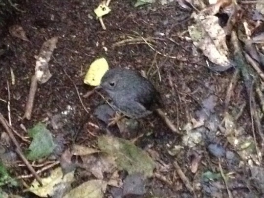


Taranaki: lake Rotokare Had a bit of a change of plan after finishing up the surf coast highway in Hawera. The plan had been to continue heading south via Whanganui to end up in Wellington, but I got a call from Lucky on the boat in Auckland to invite me out for a final crew cruise before the boat came out of the water and went on sale! I know it's hard to believe since it's taken me a month and a half to get down here, but I was technically only one day's long drive from Auckland so I definitely wanted to go. I even had more than one day! So I started heading north again, without too much hurry. The first place I headed out to was just North east of Hawera, a scenic reserve around lake Rotokare. There are a lot of reserves in NZ where they're trying to control introduced animals (possums, goats, rats, stoats) but Rotokare has one advantage: a massive pest proof fence all the way around the circumference! It even has an airlock system going in and out, you have to wait for the gate behind you to close and then check your car and surroundings for any pest before going through the second gate. The last time they caught a possum in the reserve was 2015, so they must be doing something right! It's a beautiful lake, you can walk all around the perimeter and it's a great place to see some native nz birds. I saw a couple of NZ robins which are very friendly, and also completely unlike UK robins (no red at all!) and a bird with an orange mark across the back, that in Maori legend is from Maui the hero's hand grabbing onto the bird's back. Heading north again, I stopped for a walk at a river junction through some native bush and across the river and then at another public garden at Tupare. This one felt a lot more European than Holland gardens, down to the little Tudor houses on the lawn, but a few more flowers were out in spite of the season so it was nice to walk around before heading to a camp right by the beach at Waitara, another surf coast black sand beach.
5 notes
·
View notes
Text
Mount Taranaki and Taupo, New Zealand
Day 129 – North Island and Mount Taranaki

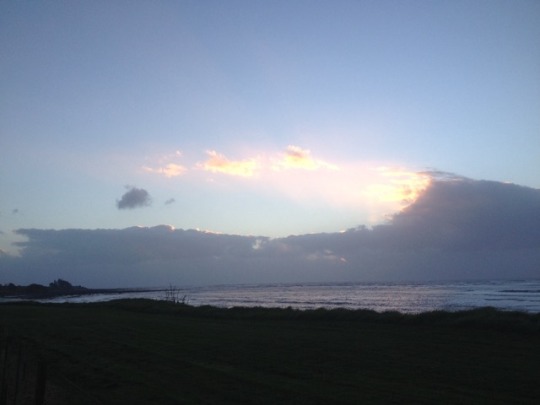
Queen Charlotte Sound
It was a rainy, overcast morning as I headed to Picton to catch the Interislander Ferry. The ferry ride took 3.5 hours to arrive in Wellington, NZ’s capitol and my jumping off point to travel the North Island. Cruising through the picturesque Queen Charlotte Sound, I was reminded of Howe Sound in Vancouver. A gradient of misty hills faded into the distance as we approached the open, rougher water of the Cook Strait. This strait – so named after the explorer James Cook, connects the Tasman Sea to the South Pacific Ocean, is considered to be one of the most dangerous and unpredictable waterways in the world. It is not uncommon for ferries to be cancelled in bad weather, but fortunately there were no issues on the day of my crossing.

Queen Charlotte Sound
I arrived in Wellington in the early afternoon, and headed straight out of town. Based on tips I had picked up from Meghan and Brendin, the Canadians I had met in Mount Cook, I had decided to make a detour on the North Island to spend the night in Mount Taranaki (also known as Mount Egmont) and I was hustling to get there in good time to make the most of the remaining daylight. I wound up the spectacular Kapiti Coast, following a narrow coastal highway northwest away from Wellington.

Pouaki Tarns Hike
I arrived in Mount Egmont National Park in New Plymouth with about 4 hours of daylight remaining, and hustled to get on the trail to the iconic Pouaki Tarns. Since I had made a last minute decision to come to Mount Taranaki, I did not know where I would be staying for the evening, but I was keeping my fingers crossed that there were beds available in the Pouaki Tarns Hut, a few hours’ hike away (with a first-come, first-served policy for beds). Since there was no guarantee that there would be a place for me to sleep, I was also prepared to hike down the mountain at night, and packed my headlamp and warmer layers just in case.

The Pouaki Tarns trail was a fairly easy hike, and I wound uphill for about 2 hours through a dense old growth forest. The entire area was a protected Kiwi zone, as many of these endangered, nocturnal birds were living in the area. Along the trail, I would also see occasional rodent traps, intended to trap predators that have been introduced to New Zealand, such as rats, possums and stoats – all of which hunt kiwis.

Coming over the Saddle at Pouaki Tarns - to this view!
Arriving at the Poauaki Tarns Hut, it was clear that there were no bunks left, and that I would have to hike back down, which I was glad to be prepared for. Continuing upwards over the saddle, I finally caught glimpse of Mount Taranaki, and knew my detour was well worth it! Mount Taranaki is an active stratovolcano, and is a near perfectly shaped cone. It is famous for its resemblance to Mount Fuji in Japan, and is often used as a stand-in for the Japanese mountain in movies. It was perfectly lit by the late afternoon sun, and it was clear that I had arrived just before that magic “golden hour”. I couldn’t believe my luck.

Mount Egmont National Park - Boardwalk to Pouaki Tarns
I continued along a boardwalk, which had been built to protect the fragile alpine scrub, arriving at Pouaki Tarns just as the sun was beginning to set. A “tarn” is the name for a mountain lake or pond that has been naturally formed by a glacier. This particular alpine pond was perfectly still, and reflected the massive profile of Mount Taranaki like a mirror. It was a stunning sight, and I could immediately see why the Canadians had recommended it so highly. There were only a few other visitors at the tarns, one of whom proposed to his girlfriend on the spot! I happily took some photos for them, and we all admired the spectacular natural beauty of the mountain as the sun began to fade.

Unfortunately I was not able to linger at the tarns, as I had another 2 hour hike downhill ahead of me in the dark. My headlamp easily illuminated the trail on my descent, and I had no issues until it unexpectedly died with an hour left to go!! I was very lucky to have a full charge on my cellphone, and ended up using my flashlight app to descend the rest of the way – not a situation I would recommend one finding themselves in.

Finally arriving back at my camper, I pulled out my trusty Campermate App to figure out where I could sleep for the night, and headed east to Rotokare Scenic Reserve, arriving very late at night. This reserve is a pest-free sanctuary, which is enclosed by an 8.2km predator proof fence (with double gates to enter). Millions of dollars have been spent eradicating mice, rats, stoats, and possums (all of which have been introduced to NZ), in order to protect the rare bird species of the area, including kiwis, hihi birds, and tieke.

Beginning of the Night-time Hike
Day 130 – Turangi and Lake Taupo
I woke up to a chorus of chirping birds, and it took me a moment to remember that I had parked overnight in a bird sanctuary! I cooked up a basic campervan breakfast (usually oatmeal and instant coffee, as I had quickly found that any food requiring refrigeration did not last long my small cooler) and set off towards Turangi and Lake Taupo, my next stops. The five-hour drive took me along rolling green hills and cattle pastures, and I fortunately had good enough cell reception - a rarity in NZ - to make some speakerphone calls back to Canada as I drove.

Rolling hills and cattle farms along my route
I arrived along the shores of Lake Taupo in the early afternoon, a massive inland lake at the centre of New Zealand’s North Island. This sparking blue lake is spread over 616 square kilometres, and is in the caldera of the Taupo Volcano, which has been inactive for several thousand years. The lake is a popular tourism destination, and is well known for watersports, cycling, swimming, and skydiving. I drove along the eastern shore of the lake to the town of Taupo, where I stopped for lunch on a lakeside patio, watching skydivers parachute into the water after their freefall. I relaxed along the waterfront for the afternoon before backtracking along my route to Turangi, a small town on the south banks of Lake Taupo. Turangi would be my jumping off point to complete the Tongariro Crossing the following day; one of New Zealand’s most famous hikes. As I had an early start the following morning (5:15am!) I had a relaxing evening and headed to bed early.
1 note
·
View note
Photo

A beautiful moment at #lakerotokare from our trip to to #newzealand this Summer. . . . . . #taranaki #nature #natureismedicine #naturephotography #abmlifeisbeautiful #plantsmakepeoplehappy (at Lake Rotokare) https://www.instagram.com/p/B-jITSvj1Au/?igshid=76rlo34rhduo
#lakerotokare#newzealand#taranaki#nature#natureismedicine#naturephotography#abmlifeisbeautiful#plantsmakepeoplehappy
0 notes
Text

02.03.19 - Lake Rotokare
Das Rechte ist unser Zelt - wir sind Minimalisten.
0 notes
Photo

Day 15 | Lake Rotokare, New Zealand > Wellington, New Zealand | Last day of my little North Island roadtrip and today I spent 6 hours driving home and visited the Govett-Brewster Art Gallery / Len Lye Centre. I’ve been wanting to go here for years as I’d always heard it was an amazing gallery - and it totally was. All the art works were totally mesmerising, fun and beautiful. Definitely worth the little detour to go there. After going there I drove home along the Surfers Highway (beautiful ocean views) and then Highway 3 and then 1. Now I’m home, all unpacked, showered and am relaxing with some Netflix before bed. Yay for a fab holiday!! . . #newplymouth #taranaki #newzealand #nz #lenlye #gallery #artgallery #architecture #architecturelovers #architecturephotography #cloudy #winter #blue #grey #reflective #destinationnz #travelnewzealand #beautifuldestinations #roadtrip #roadtripnz #drive #travel #adventure #explore https://www.instagram.com/p/Bm5cQCcDV9F/?utm_source=ig_tumblr_share&igshid=69whckr1i6ht
#newplymouth#taranaki#newzealand#nz#lenlye#gallery#artgallery#architecture#architecturelovers#architecturephotography#cloudy#winter#blue#grey#reflective#destinationnz#travelnewzealand#beautifuldestinations#roadtrip#roadtripnz#drive#travel#adventure#explore
0 notes

Photo

lake rotokare
1 note
·
View note
Photo

Day 14 | Forgotten World Highway > Lake Rotokare, New Zealand | Today I drove along the Forgotten World Highway (also know as State Highway 43). Google Maps said it would take 2 hours to drive along it while my Lonely Planet guide book said it would be 4 hours... it took 4 hours!!! It’s a crazy, rural, skinny, part gravel, part pot-holes kinda road. I’d definitely recommend driving it in a 4wd if possible. However, it was an adventure, super fun and it’s beautiful as the forests are practically untouched by humans (as you can see in this picture). So after driving through there I got to Lake Rotokare which is a little sanctuary in South Taranaki. It’s completely fenced off and a predator free space so all the birds, fish, lizards and what not can roam free and safe. There’s even Kiwi here - I didn’t see them but I sure heard them from in my tent as I was basically camping right next to them. For anyone looking to go somewhere beautiful, amazing and away from the city then go here. Just beware that there’s no network coverage or wifi which is why I’m posting this a little later than yesterday. . . . #lakerotokare #southtaranaki #taranaki #forgottenhighway #newzealand #nz #cloudy #winter #blue #forest #green #trees #ferntree #fern #untouchednature #dirtroad #highway #destinationnz #travelnewzealand #beautifuldestinations #nature #roadtrip #roadtripnz #drive #travel #adventure #explore https://www.instagram.com/p/Bm4LC5ogMeW/?utm_source=ig_tumblr_share&igshid=1y22g8gljasbo
#lakerotokare#southtaranaki#taranaki#forgottenhighway#newzealand#nz#cloudy#winter#blue#forest#green#trees#ferntree#fern#untouchednature#dirtroad#highway#destinationnz#travelnewzealand#beautifuldestinations#nature#roadtrip#roadtripnz#drive#travel#adventure#explore
0 notes
Last Seen Blogs

paltalklives
These Are the Days of our Paltalk Lives

loowna
bei morgendämmerung

yda2021
Untitled

nottspocket
Skribble Skribble

vallurite
Dimileth enjoyer