#its been raining and storming and flooding in north mississippi
Explore tagged Tumblr posts
Visit Tumblr Blog
Explore Tumblr blogs with no restrictions, modern design and the best experience.
Last Seen Tumblr Blogs


Fun Fact
25% of US internet users with an annual income of $80-100K use Tumblr.
Text
Friday, October 11, 2024
Millions are without power after Milton tore through Florida (NYT) Hurricane Milton carved an uneven path of destruction across Florida. It maintained hurricane-strength winds from its landfall on the Gulf Coast last night until its exit this morning into the Atlantic Ocean. Coastal neighborhoods were swallowed by storm surge, inland towns were flooded with rain and nearly three million homes and businesses—about a quarter of the state—remain without power. The storm also caused several intense tornadoes on Florida’s Atlantic coast that killed at least five people, including some in a retirement community. Two other hurricane-related deaths were confirmed, and emergency workers rescued hundreds of people from damaged buildings and flooded vehicles. But the densely populated Tampa Bay region appeared to have been spared from the worst-case projections of the storm’s potential damage.
FEMA spent nearly half its disaster budget in just 8 days (Politico) Eight days into the fiscal year, the federal government has spent nearly half the disaster relief that Congress has allocated for the next 12 months. The rapid spending—which is likely to accelerate as aid flows to states pulverized by Hurricanes Helene and Milton—soon will force the Federal Emergency Management Agency to restrict spending unless Congress approves additional funding [and Congress is in recess until the election]. FEMA Administrator Deanne Criswell disclosed that as of Tuesday, FEMA had spent $9 billion of the $20 billion that Congress put in FEMA’s disaster fund Oct. 1 for the fiscal year that runs through Sept. 30, 2025.
For Lebanese Americans, calm at home is surreal as Israel strikes Beirut (Washington Post) Rashad Assir started a recent Monday with a 45-minute phone call in which his mother described how she had cracked open the windows of their family home in Lebanon to reduce the pressure wave from potential explosions. She was about to leave Beirut for the mountains in the north to try to escape Israeli airstrikes. Then Assir tuned in to a Zoom call to discuss the language and graphics for his tech company’s next marketing campaign. Assir, a Lebanese American tech worker based in New York, was in a state of disbelief about his different realities, he said. Several people of Lebanese descent in the United States, a community of at least 685,000 people, according to the 2020 Census, told The Washington Post that they are feeling a sense of dystopia and isolation from those around them. In recent weeks, Sara Harb-Fisher, 29, a Lebanese American nursing student from southern Mississippi, said she has been worrying about her “family in Lebanon that is being bombed.” “My day-to-day is overwhelming,” she said. “As I’m dropping my girls off at school, logging in to class or preparing lunch, I’m constantly wondering if my grandmother is still alive.”
They Flew 7,000 Miles to Fight Haiti’s Gangs. The Gangs Are on Top. (NYT) If the burned-out cars, bullet-riddled schools, demolished buildings and desolate streets in downtown Port-au-Prince weren’t enough evidence of the terrible things that happened here, someone left an even more ominous hint: skulls in the middle of the street. A human head propped up on a stick with another on the ground beside it in front of a government office was apparently intended as a menacing message from gang members to the Kenyan and Haitian police officers trying to restore order to Haiti: Beware, we rule these streets. A Kenyan police officer wearing a bulletproof vest and helmet and patrolling in an American armored personnel carrier took a photograph with his cellphone, while another maneuvered the vehicle around the skulls. The patrol offered a glimpse into the enormous challenges the Kenyan force faces in trying to wrest control of Port-au-Prince from armed groups that have unraveled life in the country, killing indiscriminately, raping women, burning neighborhoods and leaving hundreds of thousands hungry and in makeshift shelters.
Iranian covert operations in Europe (AP) According to the head of Britain’s national intelligence agency, the country is experiencing a “staggering rise” in assassination attempts, sabotage plans, and other crimes plotted by other countries. On Tuesday, MI5 Director General Ken McCallum revealed that his agency had stopped over 20 “potentially lethal” plots backed by the government of Iran over the past two years, and warned that Tehran might cook up even more plots if the conflict in the Middle East continues to grow. All of those plots targeted Iranians living abroad in the U.K., not British politicians or leaders.
North Korea says it will cut off all roads to the South (BBC) North Korea will sever road and railway access to South Korea from Wednesday in a bid to “completely separate” the two countries. Its military said the North would “permanently shut off and block the southern border” and fortify areas on its side. The Korean People’s Army (KPA) described the move as “a self-defensive measure for inhibiting war”, claiming it was in response to war exercises in South Korea and the frequent presence of American nuclear assets in the region. It marks an escalation of hostility at a time when tensions between the Koreas are at their highest point in years. The declaration is a largely symbolic step by Pyongyang. Roads and railways leading from North Korea to the South are rarely used, and have been incrementally dismantled by North Korean authorities over the past year.
Israel Fires on U.N. Peacekeepers (Foreign Policy) Israeli forces fired on several positions used by United Nations peacekeepers in southern Lebanon on Wednesday and Thursday. According to the Lebanese mission, known as UNIFIL, Israeli soldiers targeted its headquarters at Ras Naqoura, “hitting the entrance to the bunker where peacekeepers were sheltering, and damaging vehicles and a communications system.” Two peacekeepers from Indonesia were injured. “Any deliberate attack on peacekeepers is a grave violation of international humanitarian law,” UNIFIL said, adding that it was following up with the Israeli military, which also “deliberately fired at and disabled” U.N.-operated perimeter-monitoring cameras. Israel has not commented on the incidents. Israel has recently accused UNIFIL of failing in its mission by allowing Hezbollah to entrench itself along the Blue Line. Some Israeli operations have hit near U.N. Post 6-52, where 30 Irish UNIFIL peacekeepers remain stationed despite Israel warning them to evacuate.
Nearly a Million Civilians Flee War in Lebanon, U.N. Says (NYT) Hezbollah militants fired rockets at Israeli towns and fought ground battles with Israeli troops in southern Lebanon on Wednesday, as the United Nations warned that nearly a million Lebanese had fled the spreading war between Israel and Iranian-backed groups in the Middle East. In a sign of the war’s growing scale, Israeli evacuation orders now cover a quarter of Lebanon’s land area, according to the United Nations, which says the calls have sent people fleeing from more than a hundred villages and urban areas. More than 600,000 people of Lebanon’s 5.4 million have been displaced within the country, threatening to overwhelm shelters, U.N. officials warned, and 300,000 others have fled abroad. Half of Lebanon’s public schools have been turned into shelters, the aid group Save the Children said on Wednesday.
Doctors, Nurses and Paramedics: What We Saw in Gaza (NYT) Dr. Sidhwa is a trauma and general surgeon who worked at the European Hospital in Khan Younis, Gaza, for two weeks in March and April: I worked as a trauma surgeon in Gaza from March 25 to April 8. I’ve volunteered in Ukraine and Haiti, and I grew up in Flint, Mich. I’ve seen violence and worked in conflict zones. But of the many things that stood out about working in a hospital in Gaza, one got to me: Nearly every day I was there, I saw a new young child who had been shot in the head or the chest, virtually all of whom went on to die. Thirteen in total. At the time, I assumed this had to be the work of a particularly sadistic soldier located nearby. But after returning home, I met an emergency medicine physician who had worked in a different hospital in Gaza two months before me. “I couldn’t believe the number of kids I saw shot in the head,” I told him. To my surprise, he responded: “Yeah, me, too. Every single day.” Through personal contacts in the medical community and a good deal of searching online, I was able to get in touch with American health care workers who have served in Gaza since Oct. 7, 2023. 44 doctors, nurses and paramedics saw multiple cases of preteen children who had been shot in the head or chest in Gaza.
Adré snapshot: refugee camp life (Worldcrunch) In what is probably the world’s biggest refugee camp, the desert town of Adré, Chad, the refugees from Sudan exhibit a remarkable sense of dignity. Next to some of the huts, they have built from branches and plastic sheeting, flowers grow neatly in beds surrounded by bricks. There is hardly any rubbish on the muddy paths of the town. The people organize committees to clean the toilets, which are provided by aid organizations. People help one another. Anyone who has anything left from the far-too-small food rations shares it with the community—even if they are very hungry. That is what Sudanese culture dictates. And they have brought their culture with them to the neighboring country of Chad. Since the war between Sudan’s army and the Arab militia Rapid Support Forces (RSF) escalated 17 months ago, tens of thousands have been killed in the fighting. It is simultaneously the largest humanitarian crisis and the largest refugee crisis in the world; 10 million people have been displaced, and 2 million have moved to the already fragile neighboring countries. Chad, one of the poorest countries in the world, is bearing the greatest burden with 780,000 refugees.
With roads often blocked by rebels in Congo, boats are the only alternative (AP) The overcrowded boat that capsized in eastern Congo last week killed eight members of Serge Nzonga’s family along with 70 others. Days later, he was back on the same route that claimed their lives in yet another boat lacking safety measures. Nzonga and hundreds of other passengers, including Associated Press journalists, lined up at the seaport in Goma, eastern Congo’s largest city, getting ready to board a locally made boat bound for Bukavu city on the other side of Lake Kivu, a perilous journey they would rather undertake than travel Congo’s treacherous roads. The capsizing of overloaded boats is becoming increasingly frequent in this central African nation as more people are abandoning the few available roads for wooden vessels crumbling under the weight of passengers and their goods. The roads are often caught up in the deadly clashes between Congolese security forces and rebels that sometimes block major access routes. Hundreds have already been killed or declared missing in such accidents so far this year.
Virginia congressional candidate creates AI chatbot as debate stand-in for incumbent (Reuters) After Don Beyer, a Democratic congressman in Virginia, declined to agree to any further election debates before November—Bentley Hensel, a software engineer and long-shot independent candidate in the race, is planning instead to debate an AI chatbot that he has created. DonBot, as the AI is playfully known, is being trained on Beyer’s official websites, press releases, and data from the Federal Election Commission. The debate, slated to stream October 17 online, will pit Hensel and David Kennedy, another independent, against DonBot.
4 notes
·
View notes
Text
Francine threatens flooding as its remnants move into the Tennessee Valley
Francine made landfall as a Category 2 hurricane south of Morgan City, Louisiana, on Wednesday afternoon and began to weaken after reaching shore.
A weakening Francine still has the potential to bring widespread rainfall, gusty winds, and even a slight tornado threat as far north as the mid-Mississippi Valley. The storm’s moisture will gradually move northward across the South through the end of the week.
Francine made landfall as a Category 2 hurricane south of Morgan City, Louisiana, on Wednesday afternoon and began to weaken afterward.
Weather Forecast For 77064-Houston-TX:
https://www.behance.net/gallery/201999131/Weather-Forecast-For-77064-Houston-TX
While the storm's center of circulation is expected to move well inland, its impacts could extend hundreds of miles outward.
Weather alerts related to Francine, including wind advisories, flood watches, and other hazardous weather warnings, have been issued as far north as southern Missouri and as far east as Tennessee as the remnants of the tropical cyclone progress through the South.
The primary concern is that heavy rainfall could weaken tree roots and lead to fallen trees, even though the tropical cyclone has significantly weakened.
Jamie Rhome, deputy director of the National Hurricane Center, said, "What worries me about this situation is that saturated soils can make trees more susceptible to falling from wind when the hurricane’s core moves ashore, increasing the risk of power outages."
Millions of people from the Gulf Coast to the mid-Mississippi Valley are under wind advisories, with gusts potentially reaching at least 40 mph over the next 48 hours.
Climate and Average Weather Year Round in 29617 - Greenville SC:

flickr
How much rain is expected?
As the tropical cyclone moves generally northward, widespread rainfall of 2-5 inches is expected through early the weekend.
Communities in the heavy rainfall zone include Greenwood, Mississippi; Tuscaloosa, Alabama; Memphis, Tennessee; and Jonesboro, Arkansas.
Although the intrusion of dry air and already dry soil reduce the likelihood of widespread flooding, localized flooding may occur where rain bands stall or repeatedly move over the same area, particularly in poorly-drained regions.
The combination of wind shear, increasing dry air, and rain bands moving through the Southeast could lead to the formation of funnel clouds and brief tornadoes through at least Friday.
Several Louisiana parishes were under Tornado Warnings on Wednesday before Francine made landfall, but no tornadoes have been reported so far.
While some tropical storms and hurricanes that make landfall along the Gulf Coast are known for generating tornadoes, Francine has not yet shown signs of producing such activity.
See more:
https://weatherusa.app/zip-code/weather-99589
https://weatherusa.app/zip-code/weather-99590
https://weatherusa.app/zip-code/weather-99591
https://weatherusa.app/zip-code/weather-99599
https://weatherusa.app/zip-code/weather-99602
Francine might actually bring some relief to areas grappling with increasing drought conditions from the Gulf Coast to the southern Ohio Valley. The expected 2 to 5 inches of rainfall could help alleviate drought levels that have ranged from "abnormally dry" to even "extreme," according to the latest U.S. Drought Monitor.
Similar to how heavy rains can bring relief to drought-stricken parts of central Vietnam, the much-needed precipitation from Francine could reduce water shortages in the region. Drought has also contributed to low water levels along portions of the Mississippi River, a key route for transporting goods by barge.
Although water levels remain within the acceptable range, the U.S. Army Corps of Engineers has noted that if the low levels persist, the weight of products transported could be limited, much like how drought conditions in the Mekong Delta affect transport along the river's channels.
youtube
A river gauge north of St. Louis recorded a water level of just 3 feet, a decrease of 6 feet over the past month and more than 10 feet below the typical level for this time of year.
Despite the impacts of the remnants of Beryl and early-summer flooding on the valley, water levels have generally remained below their average stage.
0 notes
Text
The February 9th to 11th 1994 Ice Storm: 30 Year Anniversary

Image from: https://www.actionnews5.com/2019/02/11/breakdown-looking-back-ice-storm-feb/
Here is the surprise I have been working on for the last several weeks. This might be coming out a little late, but that has never hurt anything anyways. February 9th to February 11th marked the 30 year anniversary of the infamous 1994 Ice Storm that hit the region. I hope that everyone enjoys the blog and learns a little something about this event.
Introduction
The February 9th to 11th, 1994 Ice Storm will be always be consider one of the worst storms to ever impact North Mississippi, Arkansas, southwestern Tennessee and portions of Louisiana and northwestern Alabama. Widespread freezing rain accumulations of 2 to 6 inches had stretched from southern Arkansas and northern Louisiana into North Mississippi and eventually into Tennessee and northwestern Alabama. Due to the historic nature of this storm, I wanted to dive into the meteorological data from this event.
Synoptic Overview of the Event
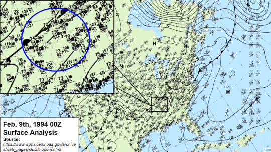
Before the storm, there was a stationary front stretching from southern Plains in Texas, into the Lower Ohio River Valley. Just to the south of that boundary, temperatures across the region were in the low to mid 70s across a large portion of Arkansas, Mississippi, Tennessee and even into northwestern Alabama. Towards Canada, there is an arctic High that was pushing the colder temperatures into the Central Plains and the upper Ohio River Valley, which eventually made its way into the Southeast.
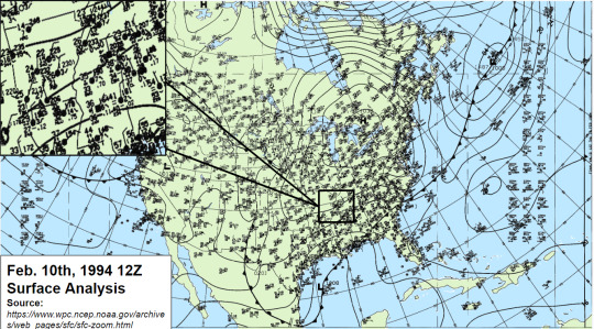
By 12z on February 10th, 1994, temperatures across the entire region had dropped to the mid 20s to the lower 30s within a 24 hour period as the stationary boundary had transition into a cold front causing the drastic drop in temperatures. By this time, the damage had been done as several places across Louisiana, Mississippi, Tennessee and Northwest Alabama had seen several inches of freezing rain. For those who did not see freezing rain, had to deal with flooding across the area where 5 to 7 inches of rain were reported.
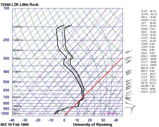
Sounding Analysis for Little Rock and Memphis

The first set of soundings show the drastic the temperature drop as the cold front had moved through the region on February 9th. The red line is the freezing mark for water at 32 F or 0 C. This was common across a large portion of the area.
By 00z on February 10th, temperatures had fallen to below freezing and at this time. several places had ethier started or have been seeing freezing rain across the area. The freezing rain accumulation had continued for several hours after the fact at this point.

Image provided by the NOAA/ESRL Physical Sciences Laboratory, Boulder Colorado from their Web site at https://psl.noaa.gov/.
For comparison, this is the reanalysis sounding over Memphis, TN at 06z on February 10th, 1994 with the red line representing the freezing mark. Memphis, TN does not have an upper site like Little Rock or Jackson, MS, so a reanalysis can be use to provide what the atmosphere would have looked like given the meteorological conditions.
Estimated Precipitation Totals

As for the freezing rain totals, I was unable to get exact storm reports from this event. However, I was able to find estimated precipitation totals from the event. Given that freezing rain is measured very similar to rain, a 1:1 ration can be applied. This means for 1 inch of freezing rain, it is equal to 1 inch of rain. The black line is approximately where the separation of rain and freezing rain had occurred at between February 9th 12z to February 12th at 12z in 1994. Places north of the black line experienced freezing rain whereas places south of the line experienced heavy rainfall and possible flooding.

Source from: https://www.localmemphis.com/gallery/weather/severe-weather/ice-storm-memphis-mid-south-1994-greenville-mississippi/522-aeadd648-43b4-425e-a9e7-856dfc8f17c9
Several places in the Arkansas/Mississippi Delta had saw 3 to 5 inches of freezing rain, with some spots seeing closer to 6 inches. Across southern Tennessee, including the Memphis area, freezing rain accumulations of 2 to 3 inches were commonly seen or even reported for this event. Even in Alabama, several places in northwestern portion of the state saw 3 to 5 inches of freezing rain, if not more. For those who did not experience the Ice Storm of 1994, they did have to contend with flooding and heavy rainfall of upwards to 5 to 7 inches. Images, like the one above, were very common across the region.
0 notes
Text
+
#i know im pmsing because i feel like im gonna cry lmaooo#but ive felt like dogshit the past two or three days#its been raining and storming and flooding in north mississippi#so my mood has just plummeted#plus im currently unmedicated#i was supposed to get a refill on my welbutrin and i got all weird and anxious and just never went back to get blood drawn for a refill#which shouldnt surprise me bc...i do this every time i have to go back (which is twice a year)#i havent had intrusive thoughts like this in almost four years#my brain keeps being like ‘lol ok but you should like...d*e. really. what even is the point? you dont have anyone anyway’#and i know that i do bc my mom is my rock but we just dont get serious often and we arent emotional people#i just feel so overwhelmed and i have no energy or motivation to do ANYTHING#all i want to do is stay in bed all day and cry#im taking my final studio art class for my art minor and im supposed to have 40 hours of work outside of class#and the thought of that effort makes me feel so sunk#plus im taking 2 african american studies classes and they both have SO much reading#like i had two novels in one class and one in the other FOR THIS WEEK#that were assigned last week??????#banderas tried to slide back in my dms and i AM proud of myself for keeping him blocked on everything and not responding#but still i think lowkey it took me back a step#and im unemployed and have no money 🙃 but like i have so much school work and reading???? there arent enough hours in the day????#anyway no one cares about any of this but i needed to vent#:’)#gonna go smoke a ciggie and kill my lungs ✌🏻😗
2 notes
·
View notes
Link

Excerpt from this New York Times story:
The governor of Louisiana declared a state of emergency as Tropical Storm Zeta churned its way Tuesday toward the Gulf Coast in the state, which already has been battered by storm after storm during this year’s prolific hurricane season.
Zeta threatens to bring life-threatening storm surge along portions of the northern Gulf Coast by late Wednesday, according to the National Hurricane Center. The storm was expected to regain strength as it moved over the Gulf of Mexico.
Zeta hit the northern Yucatán Peninsula of Mexico on Monday and Tuesday before continuing north over the gulf and toward the United States. It is forecast to make landfall Wednesday in Louisiana, which was still recovering from flooding and wind damage wrought by Hurricane Laura in late August and Hurricane Delta earlier this month.
Zeta was downgraded from a Category 1 hurricane but was forecast to become a hurricane again later on Tuesday.
A hurricane warning remained in effect Tuesday morning for Morgan City, La., to the Mississippi and Alabama border, including metropolitan New Orleans. Meteorologists predicted up to six inches of rain across these areas and to the north.

8 notes
·
View notes
Text
1 dead after tornado touches down in Atlanta area and severe weather barrels through the Southeast US
New Post has been published on https://appradab.com/1-dead-after-tornado-touches-down-in-atlanta-area-and-severe-weather-barrels-through-the-southeast-us/
1 dead after tornado touches down in Atlanta area and severe weather barrels through the Southeast US
The man died in Douglasville, Georgia, west of Atlanta. The Douglas County Fire Department responded to reports of a tree on a car with a person inside around 10:36 a.m., according to a news release from county officials.
“When they arrived on the scene, they discovered the driver trapped inside the vehicle with power lines and a tree on the vehicle,” Douglas County communications director Rick Martin said in the release. “Firefighters had to extricate the driver who we are only identifying as a male at this time until next of kin are notified.”
A tornado warning was issued at about 10:30 a.m. and lasted until 11:15 a.m. ET, with about 450,000 people in its potential path, according to the National Weather Service in Atlanta. An EF-1 tornado with 90 mph winds was confirmed in Douglas County, according to the National Weather Service. The tornado was 250 yards wide and on the ground for a mile and a half.
The extent of damage from storms in the area wasn’t clear early Monday afternoon. Atlanta Mayor Keisha Lance Bottoms tweeted photos of downed trees in her neighborhood in southwest Atlanta, while Dru Ghegan, the owner of Bonded Service Warehouse in Fulton County, shared photos that show the building suffered significant damage.
A tornado watch is in effect until 7 p.m. EDT for east-central Georgia, central South Carolina and south-central North Carolina. This includes Charlotte and Rockingham in North Carolina, Columbia and Greenwood in South Carolina and Augusta in Georgia. There are several thunderstorm watches, including ones in central Georgia, much of Alabama and eastern Mississippi, which will last until 9 p.m. ET, according to Appradab meteorologist Taylor Ward.
A couple tornadoes are possible with the thunderstorms, in addition to the risk for large hail up to the size of a quarter and isolated wind gusts up to 70 mph, according to the Storm Prediction Center.
TRACK THE STORMS WITH OUR STORM TRACKER >>>
The alerts came a day after tornadoes struck at least three cities in Mississippi, causing damage to buildings and knocking out power. The same system that spawned tornadoes over the weekend is still on the move, bringing the threat for the severe storms across the Southeast.
In addition, over the Plains, a new system is developing and will spark a separate outbreak of severe weather into the overnight hours.
There is also a severe thunderstorm watch for central Illinois and east central Missouri, including St Louis. Eastern New Mexico and West Texas are under a severe thunderstorm watch until 9 p.m. CT (10 p.m. ET).
Additionally, a new tornado watch has been issued for southeast Oklahoma and north central Texas, including Dallas. This watch is in effect until 11 p.m. CT.
Tornadoes most likely in southern Plains and Ohio River Valley
The greatest risk for severe weather through Monday night will be from Texas through Kentucky, where there is a level 3 out of 5, enhanced risk, according to the Storm Prediction Center. This includes Dallas, Fort Worth and Arlington in Texas, Fort Smith and Fayetteville in Arkansas, and Paducah in Kentucky.
This region has the best chance of seeing damaging winds, but large hail and tornadoes are also possible, especially in southeastern Oklahoma and northeastern Texas.
“Very large hail, tornadoes (a couple of which may be significant), and intense damaging winds are expected,” according to the Storm Prediction Center.
Showers and storms Monday morning were to exit the Ohio River Valley by midday, while the southern Plains remain dry most of the day.
By late afternoon, quickly moving thunderstorms will begin to form and they will persist into the night. Some of these storms are forecast to be supercells, which spin and can produce tornadoes. This tornado threat will continue into Monday night.
“A tornado risk may persist into the overnight hours as storms move from Oklahoma into parts of Arkansas/southern Missouri and approach the Mississippi River late,” according to the SPC.
Rounds of storms are possible overnight, so some locations could get hit by more than one storm — perhaps more than one severe storm.
These storms may not reach the western Ohio River Valley until early Tuesday, possibly impacting cities including Nashville, Indianapolis, St. Louis and Louisville.
Severe storms also threaten in Southeast
Monday’s severe weather threat extends across the Southeast. A level 2 out of 5, slight risk is in place for Atlanta, Birmingham, Charlotte, Charleston, Raleigh and Virginia Beach.
Marginal, level 1 out of 5, chances for severe storms stretch from the deep South through the Mid-Atlantic. Cities including Washington, Richmond and Savannah are all included in this risk area.
Unlike in the central US, the threat in the Southeast will primarily be during the daylight hours.
There have already been thunderstorms this morning, and additional storms will form during the latter half of the day.
This round will need to be watched for severe storms this afternoon and evening. Reports of tornadoes, hail and damaging winds are expected with some of the storms. Localized flash flooding will be possible with any of today’s storms, with some locations measuring 1 to 3 inches of rain.
Many states across the Southeast have seen double their normal rainfall over the last month, so even 1 to 2 inches of additional rain could lead to flash flooding.
Storms trek east Tuesday
The threat doesn’t end on Monday, however. The storm system over the Plains will make its trek toward the East Coast, fueling the risk for severe weather from the Gulf Coast through the eastern Great Lakes on Tuesday.
This puts Mississippi back at risk for tornadoes, but tornadoes could especially be possible in parts of Louisiana, Alabama and Tennessee as well, where there is a level 3 out of 5 severe weather risk.
“Large hail, damaging wind gusts and a few tornadoes will be likely along with rainfall rates in excess of an inch per hour,” said the National Weather Service office in Jackson, Mississippi.
Rounds of thunderstorms and rain showers will traverse across the Ohio and Tennessee River Valleys throughout the day Tuesday. Farther south, scattered storms will likely develop midday from eastern Texas through Georgia.
The risk for severe weather will ramp up during the afternoon and evening hours. In addition to the storms in the Gulf Coast states, some of which will turn severe, a final line or two of strong storms will likely track east from the coast through the Ohio River Valley through Tuesday night.
Flash flooding will be possible across the South thanks to the combination of heavy rainfall and all the rain that has fallen in recent days and weeks. A widespread 1-3 inches of rain is forecast across this region into Tuesday night.
This line of storms should weaken by Wednesday morning as it approaches the East Coast of the US, but isolated severe weather will remain possible.
1 note
·
View note
Link
Written by Wild Bill on The Prepper Journal.
As the snow falls and the drifts get higher, we are all familiar with the approaching seasonal end-game – even Punxsutawney Phil has stated the “melt” is less than five (5) weeks away. While celebrated as a part of the right of Spring, while searching for those first green shoots to push their way out of the still cold and damp ground, we all know what comes next from the Mississippi Valley to Gulf States and points north, south, east and west. Mother Natures gift to us all which in some cases can be overwhelming. The potential for floods even without the storms that brought them to us last year. An article submitted by Scott Huntington with a preppers twist.
Whether you live in a flood-prone place or there’s merely the possibility of a rising water line in your area, preparation is everything when it comes to flooding. Every household and workplace is different, but if you’re wondering about some common essential steps to take while preparing for a flood, here are five (5) good places to start.
Build a Preparedness Kit
One of the first things you should do if you want to be prepared for a flood is also the most straightforward. No matter where you live or who you share your life with, it’s worth taking the time to gather the things you’ll need in the event of a disaster. From there, think about where you can place them so you can easily grab them in a hurry.
You can find lots of tips at the DHS’s Ready.gov page, but here are the highlights for what you should have ready:
Any special-needs supplies, especially for children, seniors and pets
Three (3) days’ worth of food (non-perishable)
One (1) gallon of water per day for each person
Multiple flashlights
Emergency Radio with a hand-crank as well as batteries and a solar recharger built in
Well-stocked first aid kit, and the knowledge to use all its contents correctly
A survival whistle for each person, and some practiced signals
The cell/mobile phone just in case its infrastructure magically survives, a method to charge it off grid
A ham radio because the bullet above is sketchy at best
Fires tarter – weatherproof container with matches
Again, for a full list from the government, consult some of the DHS pages about emergency preparedness.
And, as a prepper don’t forget the other essentials:
A dependable knife, and a backup in a pack as these can be lost
A weapon that you are safe, familiar and accurate with in times of need
A plan as to where you are going
After you’ve gathered these supplies, consider how and where you’ll stage them. Place a few “go bags” in a known, public spot in your house. You should always have one in your automobiles and one at your place of work if you commute there via public transportation.
Make a Plan for Communication and Regrouping
Flash floods are proof enough that anybody, nearly anywhere, can be caught flat-footed by mother nature. However, even the most unpredictable flood is no excuse for not having a plan in place. Unless you live by yourself, you owe it to your family to put your heads together and come up with plans for all of the eventualities you can think of where your ability to rejoin or communicate with each other is compromised in any way.
As you put together your household plan — or a plan for your workplace, for that matter — everybody under your roof should be confident answering the following questions:
If a flood happens, will I have the means to receive official warnings and alerts?
Where will I seek shelter?
What is the safest, least flood-prone route I can take to my destination?
How will I get in touch with my family?
The people in our lives are our network and safety net, but that safety net will have big holes in it if you don’t spend time spelling out the details and making sure everybody has the same expectations should you become separated. Suppose you end up separated from your cell phone — do you have all of the relevant phone numbers memorized, recorded and with your supplies?
Once you’ve hammered out a plan, commit it to paper and practice it with your family, including the routes you’d take to make it to safety — either together or apart.
Have a Getaway Vehicle
When push comes to shove, one of the best things you can do for yourself and the ones who depend on you, if you live someplace where floods are common or a possibility, is to own a getaway vehicle. That almost always means a boat. Every person living from South Central Texas to Miami and up to the Jersey Shore now knows the value of a boat of some type.
Knowing how your boat will be powered, and that you’ll have access to extra fuel or power, is essential. Your choices come down to battery-powered or gas-powered, both of which have their ups and downs, or self-powered. Some boat batteries are rated for up to 15 days of operation with a full charge, something to know before you buy.
With a boat it is recommended that you avoid soft-bottom boats so displaced wreckage doesn’t puncture it. Apart from that, remember to choose a model that provides all the storage space you’ll need and all the seating required to accommodate your entire family. It should also be highly maneuverable and lightweight, in case you ever need to carry it to dry land.
Following the mantra of “any port in a storm” there are some less expensive options, with small footprints. More for the individual.
Know How to Prepare — And Upgrade — Your Property
For one reason or another, it’s not always possible to live outside a flood plain. After all, some of these regions might only see significant flooding events once in a blue moon or every few years.
No matter the frequency or likelihood of flooding in your area, you can take some measures around your home and property to ensure it’s prepared to withstand oncoming waters, whether it’s from heavy rains or a bonafide flood. Some examples include the following:
Consider elevating your water heater, furnace and other appliances so they’re out of harm’s way.
Have a professional look over your plumbing system and install check valves. These ensure water can’t enter your home if the water flow is reversed in your pipes.
Take a look yourself, or have a landscaping professional help you, and appraise areas on your property that could benefit from retaining walls and other barriers. Even the wise deployment of sandbags could save some of your property from harm.
Seal any cracks and imperfections in your foundation and basement walls. Choose a waterproofing compound and apply it according to the directions to provide another defense against water intrusion.
If your home has a sump pump, ensure it has a backup power source. If it doesn’t have one, you should seriously consider installing one.
Your property is probably your biggest investment, so take the time required to make sure it’s as prepared as you can make it.
Look After Your Home and Body Systems
Here’s another obvious — keep yourself and your family vaccinated. There’s no excuse not to. In the event of a flood or another type of natural disaster, there’s no telling the debris and other materials you might come into contact with. Ensuring your loved ones are protected against tetanus and other threats is an easy thing to do.
After the flood watch has been declared, you can take several precautions to prepare your home’s systems, too, now that your body’s systems are as ready as you can make them. It’s essential that you shut off your electricity and your gas in the event a flood becomes imminent, and assuming you have warning enough to do so. A flood can be bad enough, but losing your home to a preventable gas leak and resulting explosion is almost certainly the worst-case scenario.
You will find further preparation tips specific to your circumstances and your family’s needs. As you do, ensure you spend time addressing them before severe weather rolls around. There might be some scrambling required today — and maybe tomorrow — before you feel confident you’ve planned adequately. But if you do it right, it means a lot less worrying on the day the flood comes.
The post The Spring Thaw and How to Prepare for a Flood appeared first on The Prepper Journal.
from The Prepper Journal Don't forget to visit the store and pick up some gear at The COR Outfitters. How prepared are you for emergencies? #SurvivalFirestarter #SurvivalBugOutBackpack #PrepperSurvivalPack #SHTFGear #SHTFBag
1 note
·
View note
Text
Shifting Corporations Charlotte
On the lookout for Downtown Charlotte Business Movers?
I had no problem with this and immediately resent the small print again asking for a formal quote. You would possibly find a lovely quote if you are willing to email a chunk of the perfect cross country movers in Charlotte and receive charges. We look forward to showing you why we are persistently ranked as certainly one of the top Charlotte Lake Norman moving corporations! One of many guys on the crew have to be a Tetris grasp because they packed all of my belongings (with room to spare) in a container that I assumed would by no means hold every part. They were superior. To have been paid by the hour, they have been quick movers, not gradual as one would anticipate from an hourly person. Florence has strengthened to a Class three hurricane with most sustained winds of 115 miles per hour, in keeping with the National Weather Service. Although all tropical storm warnings have been cancelled, the persistent heavy rain and flash flooding from Tropical Storm Florence will proceed for a number of more hours in parts of North and South Carolina. Affordable prices and well timed delivery have helped make Charlotte Dumpster Service North Carolina the most effective dumpster rental Charlotte has to supply. Whether you’re transferring from Long Island to North Carolina for work, household causes, or simply a change of tempo, working with the appropriate long distance movers in Lengthy Island will ensure that everything goes in accordance with plan.
3020 Prosperity Church Rd Ste 253
Give you organizing suggestions, checklists, and perform a ultimate sweep for forgotten gadgets
Workplace furnishings have wraps in quilt padding
charlotte local movers
Transferring Truck and Moving Gear
8 years in the past
North Carolina shifting companies. He mentioned lane reversals on South Carolina highways are working nicely to get “people out of harm’s means.” Officials are planning to finish lane reversals on major routes with the arrival of tropical-storm winds Thursday night. The clients can also download our moving and supply app that can be utilized with the intention to get benefit from our 24/7 moving service that may be employed from the app. Your kids can become involved in the Children’s Theater of Charlotte for some time in the spotlight! The packers alternatively have been nice but we've some money missing out of my children piggy financial institution that they pack and the best way they packed simply don't make since. To make matters worse my daughter was knowledgeable late in the method that the ending date for the house she was shifting from was earlier than anticipated. How do I automate the sales course of?
Piano shifting is a delicate process. To make this course of easier on yourself, you possibly can profit from hiring local movers to assist. Our professional piano movers will quilt pad and shrink wrap your piano before leaving your home. Whether you’re shifting a small studio house or a 5-bedroom residence uShip is the proper marketplace for you to seek out the correct moving company. American Van Lines has a system of professional movers who're consultants in moving your house or office, and facing all the difficulties which will happen throughout lengthy distance relocation. With the arrival of storage pods, web sites and nationwide cargo businesses, there are numerous moving corporations in Charlotte in NC that provides reliable and skilled native and long distance movers in Charlotte NC. I solely have a 2500 Chevy cargo specific. Have a storage sale and make some further cash now! They stayed extra to help me arrange my furniture in my new place. We handle your furnishings with the most recent in tools and make sure that it arrives to the destination safe and unscathed. In its newest public advisory, the Nationwide Hurricane Center says the sluggish-transferring motion of Florence will track further inland throughout southeastern North Carolina and jap South Carolina as we speak and Saturday.
Florence continues to decrease in speeds and wind however continues to be considered a "life-threatening" hurricane because of the anticipated storm surge and rainfall, in response to the National Hurricane Center. Hurricane Florence’s center continues to be well off the coast, however the storm’s influence is already being felt in North Carolina. North Carolina's Office of the Chief Medical Examiner is now reviewing two deaths in Carteret County that were previously decided to be storm associated. 2 hundred and seventy people misplaced their lives in Mississippi as a result of the ocean rose nicely over twenty-5 feet in some areas. The shelter has been filling up with people evacuating from the coast, and locals with out a secure place to experience out the storm. Inbound lanes additionally might be reversed on four main routes to the coast, to allow people to leave, says McMaster. In Charlotte, the worst of it is going to be Saturday evening into Sunday. Our premier moving and packing firm positioned in Charlotte, NC affords full service transferring and packing for patrons and companies domestically and across the country. Now, with Google leading the world in many of the product categories it competed in, the corporate faced what Page known as n-squared issues. I go back to I'm working on a e book proper now that is purported to be out in August about the inbound advertising world view about inbound marketing as a perception system, and I feel you really are a powerful instance.
For those who have just about any concerns relating to in which as well as tips on how to employ moving companies charlotte nc reviews (https://moversandmovers.com/charlotte-moving-company/), it is possible to email us at our internet site.
1 note
·
View note
Text
MODERN DAY AUTHORITARIANS BEGAN WITH THE LIKES OF HITLER, STALIN AND TOJO.....MOST RECENT TRUMP.....NOW THE WANNABE MCCARTHY
I had an 8 o’clock appointment at the doctor’s office this morning. Blood work. I was done by 8:15. My choice to return home and keep my self quarantine Simon pure or go out for breakfast. Breakfast won out.
Harpoon Harry’s. My intent was to leave if many people were there. No problem. I made customer #6. There were more workers that customers.
The bar was empty. All 12 seats. I took the one at the end. Wanted to be sure I would not be sitting next to anyone. Even placed my cane on the seat next to me to discourage company.
A guy came in. Sixties. What did he do? Sat next to me. In fact, sat on my cane and did not realize it. All other seats at the bar empty.
All I could think was what an asshole.
I politely said “…..my cane.” He apologized. I then quietly and politely asked if he would move one or two seats away. I told him I was “…..coronavirus crazy.”
He was a good guy. Moved one seat. Better than nothing. Embarrassed, though I was also.
California Republican Kevin McCarthy is dying to be Speaker. He presently is Minority Leader.
Over the past few months, he has become consistently more bullish. Now threatening.
Thirty five companies have had their records subpoenaed by the Congressional January 6 Committee. McCarthy upset. Probably because some of those records will contain material adverse to his well being. He will never become Speaker if revealed.
Yesterday, McCarthy claimed the 35 companies were violating the law if they turned over the information requested in the subpoenas. I am unaware of any such law, nor has anyone in the media been able to identify one so far.
McCarthy said, “If these companies with Democratic orders to turn over private information, they are in violation of federal law and subject to losing their ability to operate in the United States.”
The next paragraph he uttered was even worse: “If companies still choose to violate federal law, a Republican majority will not forget and will stand with Americans to hold them fully accountable under the law.”
Would you believe such words could be spoken by a high political leader in our society? One that were he to become Speaker, would be second in line to the Presidency.
Ida did a job on New Orleans, Louisiana, and Mississippi. Vented further as it raced north. Ida hit New York City yesterday.
Flash floods! The Big Apple flooded.
Subways flowing rivers. Inoperable. Internet photos of water pouring down the stairs unbelievable.
All New York City rain fall records were shattered. In one hour, 3.5 inches of rain fell.
The National Weather Service’s New York office declared a “flash flood” for the first time in New York City.
Today is the anniversary of the worst hurricane to hit the Keys up to 1935. Considered by some to be the worse ever. Even more terrible than Andrew.
It is called the Hurricane of 1935. Male/female names not in use at that time.
A Category 5. Passed over Lower Key and Lower Matecumbe Key. Winds 200 mph. Tides 18-20 feet above normal. Four hundred killed.
The number of dead occurred because most were involved in building Henry Flagler’s Overseas Railroad. Lived in tents by night and worked by day.
Miami knew a big wind was on the way. Sent a train down the Keys to where the men were working. The train was blown off the tracks and destroyed just as it reached the workers.
Not only were hundreds killed, the storm also put the Overseas Railroad into bankruptcy. The end of Flagler’s dream.
Forget not this is hurricane season. Nowhere near over. Ends November 30.
I share this because another hurricane is already on its way. Harry. Now a tropical storm. Projected to be a Category 4 on monday. A Category 3 on sunday.
Described as a “mega storm.”
The cone shows it way out on the Atlantic at the moment. However, moving fast.
There is a good factor. The cone indicates Harry turning north well before it hits U.S. shores. It may hit New York. Appears it will not hit the southeast U.S.
Big few days in Key West this week. The women have taken over the town. It is Womenfest! From 9/1-9/5.
Thousands of lesbians and transwomen are in town.
The event began 20 years ago. It is for females 21 and older.
It is dubbed the HOTTEST party for women in the Florida Keys. Most events are clothing optional.
The Supreme Court Republican majority is sick, except for Chief Justice John Roberts. The Court yesterday voted 5-4 to uphold the new Texas abortion law. The worst anti-abortion law since Roe v. Wade was decided.
The law simple in its application. Once the fetus has a heartbeat, an abortion is banned. The heart beat generally makes its appearance in the sixth week. Most women do not know they are even pregnant in 6 weeks.
There are other negatives involved. You will have already heard them by the time you read my blog.
Something has to be done! We cannot survive with the Supreme Court as constituted. Fairness gone in most instances.
The Court is presently 6-3 Republican. There is not enough time and Democrats in power to adjust the Court’s balance by normal means. It is time for Congress to act.
There is nothing sacred in the number 9 as the number of judges permitted to constitute the Court. The number has varied over the years.
The number of Justices must be increased legally by Democrats and Democrats must be in power throughout the process. Otherwise, the job will not get done. My solution is to increase the number of Justices to 13. Now! While the Democrats have some degree of control. Thirteen will make for a 7-6 Democrat plurality.
I do not suggest the change because I am a Democrat. I want it because the present Court is destroying our country. All Republicans seem to be on a radical path I never thought I would see. From the Texas legislature to the U.S. Supreme Court.
Another example of coronavirus getting out of hand because of an ill planned event.
In the last week of June, a church camp was held. A one week event for teenagers 14-18. Masks and social distancing not required.
Two hundred ninety four campers and 41 staff. To date, nearly 200 have been infected with the virus.
Two comments in today’s Citizens’ Voice worthy of note.
The first provides food for thought.
“Can someone explain why it is OK for hundreds of thousands to enter the USA illegally at the southern border and a few Cubans fleeing a communist country have to be returned.”
The other indicative of a proper thinking Governor. One Florida lacks.
“The Governor of Hawaii is pleading with tourists to avoid the islands right now. What are our leaders doing? Scheduling more super-spreader events and giving their TDC millions of dollars so they can tell tourists to come here. Hawaii is a good example of competent leadership.”
I conclude with a be careful and be aware admonition.
This week and continuing through Labor Day weekend, the Monroe County Sheriff will be participating in Drive Sober or Get Pulled Over. Such is not merely a Keys program. It is part of a national effort to reduce drunken driving.
Enjoy your day!
MODERN DAY AUTHORITARIANS BEGAN WITH THE LIKES OF HITLER, STALIN AND TOJO…..MOST RECENT TRUMP…..NOW THE WANNABE MCCARTHY was originally published on Key West Lou
0 notes
Text
Sunday, October 11, 2020
Enrollment drops worry public schools as pandemic persists (AP) Rather than wait to see how her children’s Florida public school would teach students this fall, Erica Chao enrolled her two daughters in a private school that seemed better positioned to provide instruction online during the uncertainty of the coronavirus pandemic. The virtual lessons that Emily, 8, and Annabelle, 6, received in the spring while enrolled at a Miami-Dade County elementary school became a “free for all,” Chao said. The private school classes, by contrast, hold the girls’ attention, and their mother no longer worries they will fall behind if she doesn’t attend school with them at home. “For the first time since March, I was able to walk away,” Chao said. Parents across the country have faced similar choices about whether to keep their children in public schools as the pandemic extends into a new academic year. Some opted for private or charter schools. Others are dedicating themselves to homeschooling, hiring tutors to oversee multi-family “learning pods” or struggling to balance their children’s educations with work when school times and technology keep changing. Such personal decisions could exacerbate the financial problems of public school systems that receive a set amount of state funding for every student they enroll, which are the vast majority. With preliminary figures showing unexpected enrollment declines in many places, school officials used letters, phone calls and volunteers going door-to-door to persuade parents to register their youngsters before this month’s fall student census.
With Americans anxious to go out, walking tours pick up pace (AP) With an eerily quiet and empty stadium plaza behind him, the tour guide tried to help people picture what they would have seen there more than 160 years earlier. His audience of eight, all on foot, peered over masks at maps as he described hundreds of groceries, saloons, blacksmiths and 100,000 people living across two square miles—one of the pre-Civil War United States’ most congested areas. For so many Americans, this is a time of being cooped up, of being unable to interact with fellow humans and, in many cases, with the landscape itself. COVID-19 and its impact have kept many away from air travel, cruise ships and crowded beaches. Enter a decidedly unplugged alternative, a very concrete antidote to a suddenly more virtual life: the walking tour. Maybe not the most exciting outlet, but far better than being surrounded by the same four walls. “Our mental health matters also, and it’s very important for us ... when we’re really feeling extremely alienated from each other and feeling trapped in our homes, to walk our streets, in the safest way possible,” said Rebecca Manski of Social Justice Tours in New York City. Such tours have picked up in popularity for people seeking outdoor social activity while maintaining health safety precautions and staying in small groups.
With whipping winds, Delta drenches Louisiana, Mississippi (AP) Ripping tarps from already damaged roofs and scattering debris piled by roadsides, Delta inflicted a new round of destruction on Louisiana as it struck communities still reeling after Hurricane Laura took a similar path just six weeks earlier. Delta hit as a Category 2 hurricane, with top winds of 100 mph (155 kph) but rapidly grew weaker. By Saturday morning, it dwindled to a tropical storm with 45 mph (75 kph) winds. Still, forecasters warned of danger from storm surge and flash floods across much of southwestern Louisiana and parts of neighboring Texas. Mississippi also got its fair share of rain overnight.
Fishy idea (Foreign Policy) As the United Kingdom tries to beat a path out of the European Union, demanding a significant increase in fishing rights as it leaves the bloc’s common fisheries policy, Belgium’s Ambassador to the European Union Willem van de Voorde made an unlikely invocation on Wednesday: a charter signed in 1666 by King Charles II granting 50 fishermen from Bruges “eternal rights” to fish in England’s waters. It’s not unprecedented for centuries-old documents to play a role in British diplomacy today; the Anglo-Portuguese alliance of 1373 still stands and was invoked during the Falklands War. Although unlikely to sway the negotiations, the ambassador’s intervention underscores how fraught discussions over fishing rights have become.
Europe’s Economic Recovery Is a Summer Memory (NYT) What faint hopes remained that Europe was recovering from the economic catastrophe delivered by the pandemic have disappeared as the lethal virus has resumed spreading rapidly across much of the continent. After sharply expanding in the early part of the summer, Britain’s economy grew far less than anticipated in August—just 2.1 percent compared with July, the government reported on Friday, adding to worries that further weakness lies ahead. Earlier in the week, France, Europe’s second-largest economy, downgraded its forecast for the pace of expansion for the last three months of the year from an already minimal 1 percent to zero. Over all, the national statistics agency predicted the economy would contract by 9 percent this year. The diminished expectations are a direct outgrowth of alarm over the revival of the virus. France reported nearly 19,000 new cases on Wednesday—a one-day record, and almost double the number the day before. The surge prompted President Emmanuel Macron to announce new restrictions, including a two-month shutdown of cafes and bars in Paris and surrounding areas. In Spain, the central bank governor warned this week that the accelerating spread of the virus could force the government to impose restrictions that would produce an economic contraction of as much as 12.6 percent this year. The European Central Bank’s chief economist cautioned on Tuesday that the 19 countries that share the euro currency might not recover from the disaster until 2022. Summer increasingly feels like a long time ago.
North Korea parades huge, new ICBM, but Kim Jong Un stresses deterrent nature (Washington Post) North Korea showed off what appeared to be a huge, new inter-continental ballistic missile at a military parade Saturday, although leader Kim Jong Un stressed the deterrent nature of the weaponry on display—and even held out an olive branch to neighbor South Korea. The military parade, marking the 75th anniversary of the ruling Workers’ Party, featured a vast array of modernized military systems, from small arms through antitank and air- defense systems. The most closely watched, however, was what looked to be four huge, new liquid-fueled ICBMs, rolling through the main square in Pyongyang on 11-axle vehicles. Military experts—monitoring the parade through North Korean state television—said the new missile would be one of the largest road-mobile ICBMs in the world if it becomes operational, and could represent the threatened new “strategic weapon” Kim had talked of at the start of this year. For the international community, Kim’s message was: North Korea was a military force to be reckoned with, but not a threat.
Azerbaijan and Armenia Agree to Cease-Fire in Nagorno-Karabakh (NYT) Azerbaijan and Armenia negotiated a limited cease-fire early Saturday after almost two weeks of fierce fighting over a disputed province, with the goal of pausing combat long enough to collect bodies from the battlefield and to exchange prisoners. The Russian-brokered agreement, which takes effect at noon on Saturday, was short on specifics. The issue of the how the cease-fire would play out on the front lines was left to the sides to agree to in “additional” talks. People fleeing the fighting on Friday described the violence as more intense than what took place during the yearslong war between Armenia and Azerbaijan in the early 1990s that killed some 20,000 people and displaced about a million, mostly Azerbaijanis.
Clashes erupt between ultra-Orthodox and police, youth set fire to city (Jerusalem Post) Clashes broke out between police and dozens of ultra-Orthodox people late Thursday night in Modi’in Illit as a gathering was held in a synagogue in violation of coronavirus and lockdown regulations, Walla reported. Several ultra-Orthodox were arrested, and youth set aflame trees and vegetation throughout the city in outcry. A video of the scene shows dozens of ultra-Orthodox people in clashes with the police as violence erupts among the crowd, and the congregants yell “shame on you,” at the police.
Nigerian protesters demand end of an anti-robbery police unit that robs people (Washington Post) The police officers accused him of speeding, but Dare Olaitan felt that wasn’t true. The 29-year-old filmmaker in Nigeria’s biggest city, Lagos, recalls requesting proof. “Then they slapped me, yanked away my phone and keys and said, ‘We are going to an ATM,” Olaitan said. The men, who’d pulled him over in an unmarked van, identified themselves as part of the Federal Special Anti-Robbery Squad, or SARS, a Nigerian police unit that has been tasked over the last three decades with fighting violent crime, including banditry and kidnapping. Similar tales blazed across social media in recent days as thousands of protesters filled the streets in several Nigerian cities, urging the leaders of Africa’s most populous nation to disband the squad, which they say routinely commits the kind of crimes it is supposed to thwart. Human rights activists have campaigned against SARS for years, but violent videos that surfaced online this week shoved a fresh spotlight on what demonstrators condemned as police brutality. A number of Nigerian celebrities took up the cause, helping #EndSARS go massively viral. As pressure mounted, Nigerian President Muhammadu Buhari vowed Friday to investigate the squad.
1 note
·
View note
Text
Hurricane Francine tears through Louisiana, unleashing powerful winds and torrential rains, leaving 400,000 without power.
New Orleans recorded wind gusts of 78 and 76 mph as Hurricane Francine's eyewall swept through the city on Wednesday evening. Dulac reported a gust of 97 mph, while Eugene Island experienced a gust of 105 mph. Although Francine has since weakened to a tropical storm, its impacts are expected to continue through the end of the week.
Hurricane Francine struck the Louisiana coast on Wednesday, unleashing destructive 100 mph winds and a dangerous storm surge that left hundreds of thousands without power across the Southeast. The storm dumped several inches of rain, triggering a rare Flash Flood Emergency.
Climate and Average Weather Year Round in 76063-Mansfield-TX:
https://www.behance.net/gallery/201826183/Weather-Forecast-For-76063-Mansfield-TX
Francine's eye made landfall at 5 p.m. CT in Terrebonne Parish, bringing hurricane-force gusts to the southern part of the state, including areas near Baton Rouge.
New Orleans recorded wind gusts of 78 and 76 mph as Hurricane Francine's eyewall passed through the city on Wednesday evening. Dulac experienced a gust of 97 mph, while Eugene Island saw a gust of 105 mph.
Though Francine has since been downgraded to a tropical storm, its dangerous and potentially life-threatening effects are expected to persist well inland.
Power outages continued to rise throughout Wednesday and into Thursday morning, with nearly 400,000 outages reported in Louisiana and about 17,000 in Mississippi, according to poweroutage.us.
A Flash Flood Emergency was declared for parts of the New Orleans metro area, where 0.50 inches of rain fell in just 9 minutes and 4.5 inches accumulated within three hours. Life-threatening flooding remained a concern as rain persisted.
As water levels rose, emergency services began receiving calls for help from individuals trapped with no means of escape.
According to Lafourche Parish Sheriff Craig Webre, more than two dozen people, including young children, required rescue from the flooding.
The sheriff's office reported that deputies responded to calls from residents trapped in housing units in Thibodaux due to rising floodwaters from the heavy rain.
All residents were safely evacuated, with most being taken to emergency shelters.
Additionally, Francine's conditions posed a risk of tornadoes and severe thunderstorms, with these threats expected to continue into Friday morning.
Weather Forecast For 29204 - Columbia SC:

flickr
Francine disrupts travel in New Orleans as emergency responders remain on standby.
Travel in the region has been significantly affected, with airlines canceling flights to and from Louis Armstrong New Orleans International Airport through Thursday morning. Some parishes, including Cameron Parish, which experienced flooding before landfall, have imposed mandatory curfews from Wednesday afternoon until sunrise on Thursday.
In response to Francine's impact, President Joe Biden has approved an emergency declaration for Louisiana.
"After declaring a state of emergency, it has become clear that the severity of this storm exceeds the capabilities of state and local governments to effectively respond," said Louisiana Governor Jeff Landry. "Federal assistance is crucial to save lives and protect property."
Where is Francine headed next?
According to the National Hurricane Center (NHC), Francine is projected to gradually turn north, moving its center across southeastern Louisiana and southwestern and central Mississippi on Thursday.
While the center of the storm is expected to track well inland, its effects could extend hundreds of miles outward.
Weather alerts, including wind advisories, Flood Watches, and other hazardous weather warnings, have been issued as far north as southern Missouri and as far east as Tennessee as the remnants of the cyclone move through the South.
See more:
https://weatherusa.app/zip-code/weather-96768
https://weatherusa.app/zip-code/weather-96769
https://weatherusa.app/zip-code/weather-96770
https://weatherusa.app/zip-code/weather-96771
https://weatherusa.app/zip-code/weather-96772
Since 2000, Francine marks the eighth hurricane to make landfall in Louisiana. FOX Weather Correspondent Robert Ray has reported on most of these landfalls.
“These people are tough as nails,” Ray remarked from Houma, Louisiana, on Wednesday.
Francine, which became a hurricane on September 10, arrived at the peak of the 2024 hurricane season when named storms are most likely to impact the Atlantic Basin. As Francine moves north and eventually dissipates, the NHC is also monitoring several other systems in the Atlantic.
youtube
Francine was the third hurricane to make landfall in the continental U.S. during the 2024 season. Hurricane Beryl struck Matagorda, Texas, on July 8 as a Category 1 storm. Approximately a month later, Hurricane Debby intensified into a Category 1 hurricane before making landfall near Steinhatchee, Florida, on August 5.
0 notes
Photo

Tropical Storm Claudette forms along U.S. Gulf Coast, brings rain and floodsThunderstorms and high winds on the east side of Tropical Storm Claudette battered the Florida panhandle and much of Alabama on Saturday, as the weather system moved toward the North Carolina coast.The National Hurricane Center declared Claudette organized enough to qualify as a named storm at 4 a.m. Saturday, well after the storm’s center of circulation had come ashore southwest of New Orleans. By mid-morning it was 75 miles (120 kilometers) north-northeast of the city with winds clocked at 40 mph (65 kph). It was moving north-northeast at 14 mph (22 kph), and most of the heavy weather was happening far to the north and east of the center.After dumping flooding rains north of Lake Pontchartrain in Louisiana and along the Mississippi coast, the storm was inundating the Florida panhandle and, well inland, a broad expanse of Alabama. The National Weather Service issued a series of possible tornado warnings Saturday morning in north Florida and south Alabama.Parts of inland Mississippi and Georgia were getting heavy rain from Claudette as well. And even though the storm was weakening, the National Hurricane Center issued a tropical storm watch for parts of the North Carolina coast, which could feel the effects by Sunday night. The storm was forecast to cross into the Atlantic Ocean on Monday, and regain tropical storm strength over open water Tuesday.Residents of Pace, Florida, called 911 to report a possible twister that tore the roofs off two homes and damaged at least three others.“Nobody’s hurt,” said Sarah Whitfield, spokeswoman for Santa Rosa County, where the Florida homes were damaged. “We’re just thankful it happened after sunrise,” not overnight as people slept.An 18-wheeler hit several utility poles and flipped on its side during the storm early Saturday. Debris from the accident, including a collapsed utility pole, turned into projectiles and struck a passing SUV, according to the Florida Highway Patrol.The accident report said wind gusts of 85 mph were clocked in the area. Highway Patrol officials were to close both lanes of the Interstate 10 bridge between Escambia and Santa Rosa counties due to high winds.The county received two calls about trees falling onto homes, but no one was home at the time.“We’re seeing a few roads flooding with some high waters,” said Escambia County Spokeswoman Laura Coale, who said some cars had been stranded.The storm left tens of thousands without power and some flights were being cancelled or delayed at Pensacola International Airport.“We have a lot of visitors that are here vacationing,” she said. “Red flags flying out at the beaches so there’s absolutely no swimming.”
0 notes
Link
1 dead after tornado touches down in Atlanta area and severe weather barrels through the Southeast US The man died in Douglasville, Georgia, west of Atlanta. The Douglas County Fire Department responded to reports of a tree on a car with a person inside around 10:36 a.m., according to a news release from county officials. “When they arrived on the scene, they discovered the driver trapped inside the vehicle with power lines and a tree on the vehicle,” Douglas County communications director Rick Martin said in the release. “Firefighters had to extricate the driver who we are only identifying as a male at this time until next of kin are notified.” A tornado warning was issued at about 10:30 a.m. and lasted until 11:15 a.m. ET, with about 450,000 people in its potential path, according to the National Weather Service in Atlanta. An EF-1 tornado with 90 mph winds was confirmed in Douglas County, according to the National Weather Service. The tornado was 250 yards wide and on the ground for a mile and a half. The extent of damage from storms in the area wasn’t clear early Monday afternoon. Atlanta Mayor Keisha Lance Bottoms tweeted photos of downed trees in her neighborhood in southwest Atlanta, while Dru Ghegan, the owner of Bonded Service Warehouse in Fulton County, shared photos that show the building suffered significant damage. A tornado watch was in effect until 7 p.m. EDT for east-central Georgia, central South Carolina and south-central North Carolina. This included Charlotte and Rockingham in North Carolina, Columbia and Greenwood in South Carolina and Augusta in Georgia. There were several thunderstorm watches, including ones in central Georgia, much of Alabama and eastern Mississippi, which will last until 9 p.m. ET, according to CNN meteorologist Taylor Ward. A couple tornadoes are possible with the thunderstorms, in addition to the risk for large hail up to the size of a quarter and isolated wind gusts up to 70 mph, according to the Storm Prediction Center. TRACK THE STORMS WITH OUR STORM TRACKER >>> The alerts came a day after tornadoes struck at least three cities in Mississippi, causing damage to buildings and knocking out power. The same system that spawned tornadoes over the weekend is still on the move, bringing the threat for the severe storms across the Southeast. In addition, over the Plains, a new system is developing and will spark a separate outbreak of severe weather into the overnight hours. There is also a severe thunderstorm watch for central Illinois and east central Missouri, including St Louis. Eastern New Mexico and West Texas are under a severe thunderstorm watch until 9 p.m. CT (10 p.m. ET). Additionally, a new tornado watch has been issued for southeast Oklahoma and north central Texas, including Dallas. This watch is in effect until 11 p.m. CT. Tornadoes most likely in southern Plains and Ohio River Valley The greatest risk for severe weather through Monday night will be from Texas through Kentucky, where there is a level 3 out of 5, enhanced risk, according to the Storm Prediction Center. This includes Dallas, Fort Worth and Arlington in Texas, Fort Smith and Fayetteville in Arkansas, and Paducah in Kentucky. This region has the best chance of seeing damaging winds, but large hail and tornadoes are also possible, especially in southeastern Oklahoma and northeastern Texas. “Very large hail, tornadoes (a couple of which may be significant), and intense damaging winds are expected,” according to the Storm Prediction Center. The Federal Aviation Administration issued a ground stop at Dallas Fort Worth International Airport, airport spokesperson Bill Begley told CNN. Showers and storms Monday morning were to exit the Ohio River Valley by midday. By late afternoon, quickly moving thunderstorms will begin to form and they will persist into the night. Some of these storms are forecast to be supercells, which spin and can produce tornadoes. This tornado threat will continue into Monday night. “A tornado risk may persist into the overnight hours as storms move from Oklahoma into parts of Arkansas/southern Missouri and approach the Mississippi River late,” according to the SPC. Rounds of storms are possible overnight, so some locations could get hit by more than one storm — perhaps more than one severe storm. These storms may not reach the western Ohio River Valley until early Tuesday, possibly impacting cities including Nashville, Indianapolis, St. Louis and Louisville. Severe storms also threaten in Southeast Monday’s severe weather threat extends across the Southeast. A level 2 out of 5, slight risk is in place for Atlanta, Birmingham, Charlotte, Charleston, Raleigh and Virginia Beach. Marginal, level 1 out of 5, chances for severe storms stretch from the deep South through the Mid-Atlantic. Cities including Washington, Richmond and Savannah are all included in this risk area. Unlike in the central US, the threat in the Southeast will primarily be during the daylight hours. There have already been thunderstorms this morning, and additional storms will form during the latter half of the day. This round will need to be watched for severe storms this afternoon and evening. Reports of tornadoes, hail and damaging winds are expected with some of the storms. Localized flash flooding will be possible with any of today’s storms, with some locations measuring 1 to 3 inches of rain. Many states across the Southeast have seen double their normal rainfall over the last month, so even 1 to 2 inches of additional rain could lead to flash flooding. Storms trek east Tuesday The threat doesn’t end on Monday, however. The storm system over the Plains will make its trek toward the East Coast, fueling the risk for severe weather from the Gulf Coast through the eastern Great Lakes on Tuesday. This puts Mississippi back at risk for tornadoes, but tornadoes could especially be possible in parts of Louisiana, Alabama and Tennessee as well, where there is a level 3 out of 5 severe weather risk. “Large hail, damaging wind gusts and a few tornadoes will be likely along with rainfall rates in excess of an inch per hour,” said the National Weather Service office in Jackson, Mississippi. Rounds of thunderstorms and rain showers will traverse across the Ohio and Tennessee River Valleys throughout the day Tuesday. Farther south, scattered storms will likely develop midday from eastern Texas through Georgia. The risk for severe weather will ramp up during the afternoon and evening hours. In addition to the storms in the Gulf Coast states, some of which will turn severe, a final line or two of strong storms will likely track east from the coast through the Ohio River Valley through Tuesday night. Flash flooding will be possible across the South thanks to the combination of heavy rainfall and all the rain that has fallen in recent days and weeks. A widespread 1-3 inches of rain is forecast across this region into Tuesday night. This line of storms should weaken by Wednesday morning as it approaches the East Coast of the US, but isolated severe weather will remain possible. Source link Orbem News #area #Atlanta #Barrels #Dead #severe #Severeweather:1deadaftertornadotouchesdowninAtlantaareaandsevereweatherbarrelsthroughtheSoutheastUS-CNN #Southeast #Tornado #touches #Weather
0 notes
Link
This is a long post, because whatever this system was, it was an aberration and merits a long story. It messed around with peoples lives and property and mental health from the Midwest down through the Southeast and then up the coast with tornados, thunderstorms, deluges, hail, with awful consequences such as the boat accident in Branson, Missouri and the floods in the Mid-Atlantic states.

Simulation of jet stream pattern July 22. (VentuSky.com)
Excerpt:
Is it July or March? A rare and steep summer dip in the jet stream has brought an incredibly wacky week of weather to the Lower 48.
Usually, this fast-moving air current along which storms track retreats in summer, meandering listlessly in Canada.
Not so in recent days.
“The jet stream has stretched all the way from Canada to the Gulf of Mexico over the eastern U.S., helping to trigger the intense tornado outbreak in Iowa, and the persistent, torrential rains in the Mid-Atlantic,” said Jeff Halverson, Capital Weather Gang’s severe weather expert. “Even veteran meteorologists with decades of experience are astounded by the extreme nature of this jet stream pattern.”
As this jet stream and pool of cold air in its wake have interacted with all of the intense midsummer heat over the Lower 48, it has incited all sorts of unusual and severe weather. Not only has the pattern been extreme but it has also become stuck in place. This has led to day after day of remarkable and frequently disruptive weather.
Thursday
Things kicked off Thursday when the jet stream dived south through the Midwest, triggering at least a dozen confirmed tornadoes in Iowa. Despite a direct hit to Marshalltown, a city of 28,000, and hefty damage on the outskirts of Pella, there were no fatalities — a testament to the high lead time provided by the National Weather Service in warnings issued that day.
Farther south Thursday, a derecho with widespread 60 to 80 mph gusts tracked from southern Nebraska down into northern Arkansas, spelling disaster at Table Rock Lake in Branson, Mo. The storm had a history of producing damaging winds — up to 89 mph in Lecompton, Kan. — along its nearly 500-mile track. The well-forecast storm caught some off guard, killing 17 people when it sank a duck boat trapped in high winds and waves.
Friday
The upper-level disturbance wrapped up in the diving jet stream plowed farther south and east Friday, shifting the threat for severe storms over the Ohio and Tennessee valleys. The Storm Prediction Center had a “moderate risk” of severe weather over portions of Indiana, Kentucky and Tennessee. The biggest threat proved to be damaging winds. The National Weather Service received 395 reports of high wind or wind damage. But that wasn’t all. Softball-size hail — incredibly rare in July, thanks to high freezing levels in the atmosphere — was reported in Kentucky.
Saturday
The weird jet stream helped to drag moisture up the Eastern Seaboard, setting the stage for prolific rains. At Reagan National Airport near Washington, four inches came down. Since 1941, only a dozen other calendar days have seen four inches or more.
To the south, a pair of nighttime supercell storms northeast of Chattanooga, Tenn., merged and formed a line around 2 a.m. Saturday. This line collapsed south into Georgia.
The National Weather Service hoisted a severe thunderstorm watch for the Atlanta metro area at 3 a.m. as the windy storms raced south during the morning rush hour. As soon as they were gone, the sun came out, the atmosphere reloaded, and the stage was set for another round of dangerous storms in the afternoon. For the second time that same day, a severe thunderstorm watch was in effect
.One storm that afternoon even split and formed two new supercells. Thanks to northwest flow and an unusual turning of the winds owing to the bizarre jet stream, the “left split” supercell blew up into a massive storm. The really weird part? This storm was spinning clockwise, or anticyclonic. Less than 2 percent of mature supercells do so. That storm went on to produce tennis-ball-size hail in Dacula, Ga. — the second-largest hailstone on record in the Peach State in July.
Sunday-Monday
Storms continued south into Florida on Sunday, and on Monday, they threw it into reverse — literally. Though the steering flow pushed clouds southeast, the cluster back-built westward along the front at the same rate. This gave the appearance of a stationary line of storms at the mouth of the Mississippi River, producing nearly 200,000 lightning strikes over the course of its 19-hour life span. It was nuts.
Tuesday-Wednesday
The stalled storm system has been blamed for widespread flash flooding from the Carolinas up through New England, drawing a fire hose of tropical moisture up the East Coast. Baltimore has picked up more than 15 inches of rain, a July record.
And the same system, but on its back side messed with the western states
While the West Coast has not dealt with storminess, it has endured extreme weather of its own. Like a see-saw, the jet stream has lifted north allowing scorching heat to swell from the Desert Southwest to Seattle.Death Valley, Calif. soared to a daily record of 127 degrees Tuesday, very close to its highest temperature measured in decades: 129 degrees on June 30, 2013. Seattle is predicted to have its longest streak of hot weather on record with temperatures at least 88 degrees for a week. The Weather Service is also calling for “very dangerous heat” in the Sacramento Valley.
2 notes
·
View notes
Photo

Hurricane Zeta crashes into storm-weary Louisiana
Hurricane Zeta slammed into storm-weary Louisiana on Wednesday with New Orleans squarely in its path, threatening to push up to 9 feet of sea water inland and batter homes and businesses with fierce winds in a Gulf Coast region already pounded by multiple storms this year.
Some roads were flooded near the coast, where forecasters said Zeta was making landfall around Terrebone Bay near Cocodrie, an unincorporated fishing village at the end of a highway.
Rain pelted the French Quarter in New Orleans, and streams of water ran off roofs. Trees whipped back and forth in the wind, though a few people were still out on Bourbon Street with umbrellas or in slow-moving cars. The iconic streetcars were idled and City Hall closed, Mayor LaToya Cantrell said.
Zeta had top sustained winds of 177 km / h (110mph) as a Category-2 hurricane and was the 27th named storm of a historically busy Atlantic hurricane season - with over a month left before it ends.
Tropical storm warnings were issued as far away as the north Georgia mountains, highly unusual for the region. New Orleans has been in the warning areas of seven previous storms that veered east or west this season. Zeta was staying on course.
“I don't think we're going to be as lucky with this one,” city emergency director Collin Arnold said.
Zeta had been predicted to hit as a relatively weak Category-1 hurricane, but Louisiana residents awoke to updated forecasts predicting a Category-2 at landfall.
“The good news for us - and look, you take good news where you can find it - the storm's forward speed is 27 km / h (17 mph). That's projected to increase, and so it's going to get in and out of the area relatively quickly, and then we're going to be able to assess the damage more quickly, ”Governor John Bel Edwards said in an interview on the Weather Channel.

Satellite image showing Hurricane Zeta in the Gulf of Mexico nearing Louisiana [NOAA via AP]
Officials urged people to take precautions and prepare to shelter in place, and a business-as-usual atmosphere in the morning in New Orleans diminished as the storm neared and grew stronger. Traffic slowed, and restaurants and coffee shops shut down.
“This year, the storms have been coming back-to-back. They've been avoiding New Orleans but finally decided to come, ”cookie shop worker Curt Brumfield said as he stowed empty boxes in trash cans outside and others boarded up the windows.
The winds were picking up and water was rising above the docks in Jean Lafitte, a small fishing town south of New Orleans that takes its name from a French pirate. Workers drove truckloads of sand to low-lying areas where thousands of sandbags were already stacked for previous storms.
“We're going to get a lot of water fast,” said the mayor, Tim Kerner Jr. “I'm optimistic regarding the tidal surge because of the speed of the storm, but we're not going to take it for granted. ”
Zeta could lash the northern Gulf Coast with wind, rain and storm surge more than 150 miles (241 kilometers) east of New Orleans. In Mississippi, the city of Pass Christian ordered all boats out of the harbor, and Dauphin Island, Alabama, shut off water and sewer service in that typically are swamped in areas storms.

Louisiana residents boarding up their storefronts as they prepare for the arrival of Hurricane Zeta, which is expected to make landfall as a Category-2 storm, in New Orleans, Louisiana, US [Kathleen Flynn/Reuters]
New Orleans officials announced that a turbine that generates power to the city aging drainage pump system broke down on Sunday, with no quick repair in sight. There was enough power to keep the pumps operating if needed, but little excess power to tap if other turbines fail, officials said.
Officials said they were running through contingencies to provide power and make repairs where needed should there be other equipment problems. Forecasts called for anywhere from five to 15 centimetres (two to six inches) of rain to fall in the New Orleans area, but Zeta is expected to be a relatively fast-moving storm, possibly mitigating the flood threat.
By Wednesday afternoon, Zeta's top winds had risen to just shy of a major, Category 3 storm, according to the US National Hurricane Center.
Zeta raked across Mexico's Yucatan Peninsula on Tuesday, toppling trees and briefly cutting power to more than 300,000 people but causing no deaths, before strengthening again along a path slightly east of Hurricane Laura, which was blamed for at least 27 Louisiana deaths after it struck in August, and Hurricane Delta, which exacerbated Laura's damage in the same area just weeks later.
Hurricane warnings stretched from Morgan City, Louisiana to the Alabama / Mississippi state line, including Lake Pontchartrain and metropolitan New Orleans. The deteriorating weather forced early voting sites to close for hours in the western Florida Panhandle, where Republicans dominate.
Tropical storm warnings covered a large swath of the South, from Louisiana and Mississippi into Alabama and Georgia, including all of the Atlanta area, where winds could gust up to 89 km / h (55 mph) early Thursday. Winds could be “especially severe” in the southern Appalachian Mountains, where flash flooding is possible, the hurricane center said.
Edwards asked President Donald Trump for a disaster declaration in advance of the storm. He and Alabama Governor Kay Ivey both declared emergencies, as did Mayor Andrew “FoFo” Gilich in Biloxi, Mississippi. Trump declared an emergency for Louisiana on Tuesday evening.
An average season sees six hurricanes and 12 named storms. This extraordinarily busy season has focused attention on climate change, which scientists say is causing wetter, stronger and more destructive storms.

Tourists walk past debris littering the street after Hurricane Zeta's landfall in Playa del Carmen, Mexico. Zeta is leaving Mexico's Yucatan Peninsula on a path that could hit New Orleans Wednesday night [AP Photo/Tomas Stargardter]
After Hanna, Isaias, Laura, Sally and Delta, Zeta will tie a record set in 1886 and repeated in 1985 for six hurricanes smacking the continental US, according to Colorado State University hurricane researcher Phil Klotzbach.
And as the 11th named storm to make landfall in the continental US, Zeta will set a new record, well beyond the nine storms that hit in 1916.
“I'm physically and mentally tired,” a distraught Yolanda Lockett of Lake Charles said outside her New Orleans hotel. She's one of about 3,600 evacuees from Laura and Delta still sheltering.
. #world Read full article: https://expatimes.com/?p=12861&feed_id=12365
0 notes
Text
Hurricane Delta leaves one dead in Louisiana and brings tornado threat to Carolinas
New Post has been published on https://appradab.com/hurricane-delta-leaves-one-dead-in-louisiana-and-brings-tornado-threat-to-carolinas/
Hurricane Delta leaves one dead in Louisiana and brings tornado threat to Carolinas
An 86-year-old man in St. Martin Parish died after a fire started as he was fueling a generator in a shed, Louisiana Gov. John Bel Edwards said at a news conference Sunday.
Remnants of the storm spawned at least two tornadoes in north and central Georgia Saturday, injuring two people, according to the National Weather Service.
More than 400,000 households and businesses were in the dark Sunday morning after Hurricane Delta, which hammered Louisiana, weakened to a post-tropical cyclone and headed across the Southeast.
Most of the customers without electricity, about 310,000 of them, were in Louisiana, where the hurricane made landfall Friday, according to Sunday afternoon estimates from poweroutage.us. More than 50,000 customers in Texas were without power, while Mississippi reported almost 13,000 outages.
Almost 8,000 were without power in Georgia and South Carolina, where Delta was expected to dump rain Sunday before moving up the East Coast.
In Lilburn, Georgia, a train derailed after heavy rain overnight. Firefighters found the train on its side, with 38 cars derailed, some of them on fire. The locomotive’s engineer and conductor were taken to the hospital with minor injuries, according to Gwinnett County Fire and Emergency Services.
One of the Georgia tornadoes was an EF1 with winds between 87 and 90 miles an hour that struck near Covington, about 35 miles east of Atlanta, and injured two people, according to the National Weather Service. It damaged a homeless shelter, displacing 30 people, the city’s emergency management director, Jody Nolan, told Appradab.
The other was an EF0 that hit Pike County, some 51 miles south of Atlanta.
Delta still had 25 mph winds as it passed about 60 miles south of Nashville late Sunday morning. It was expected to weaken significantly by early Monday, according to the National Weather Service.
Northeast Georgia and the western portion of Virginia and the Carolinas could see up to 6 inches of rain, creating flash flooding risks across the region, the weather service said. The Central Appalachians and southern New Jersey could get drenched as well, forecasters said.
How to help storm victims
Tornadoes are possible across the Carolinas on Sunday, the weather service said. Flash flooding is possible from north Georgia to southern Virginia.
Still recovering from Laura, Lake Charles hit again
As Delta moved away from Louisiana, it left parts of the southwestern corner of the state with 17 inches of rain.
“Even if it wasn’t quite as powerful as Hurricane Laura, it was much bigger,” Edwards said Saturday. “Obviously, this was a very serious, very large and powerful storm that produced significant amounts of damage.”
Delta left a trail of “hazards like flooded roads, downed power lines and displaced wildlife” across the state, Edwards tweeted. He urged residents to remain vigilant.
More than a hundred roads and 35 bridges were closed, Edwards said Sunday, and traffic lights were out at many intersections.
Lake Charles, which faced the brunt of Hurricane Laura’s destruction, saw significant flooding after Delta passed through, and Delta’s flooding surpassed Laura’s, Mayor Nic Hunter said.
The city of 78,000 is still recovering from Laura’s 150-mph winds in August and now must deal with the double whammy of wind and flood damage, the mayor said, adding that Delta forced more residents to evacuate than did Laura.
Highways out of Lake Charles were packed as people fled Delta, and about 7,000 residents were still displaced from Laura when Delta hit, he said.
“Already we’re picking up the pieces, but we have quite a road ahead of us. There’s a lot of homes that were damaged from Laura, and now it’s just adding insult to injury,” the governor said Saturday.
More than 9,000 people are still in shelters in the state, Edwards said, but the vast majority — 8,230 — are evacuees from Hurricane Laura.
In Texas, a utility company said it could take up to a week to restore power to customers along the state’s southeastern border.
Delta sets records
Hurricane Delta was the 25th named storm of the 2020 Atlantic hurricane season.
It hit Mexico’s Yucatan Peninsula on Wednesday before making landfall with 100-mph winds near Creole, Louisiana, not far from where Laura made landfall less than two months ago.
With Delta, five hurricanes have made landfall in the US this year — the most since 2005 — and 10 named storms have hit this this year in the continental US — the most since nine landfalls were recorded in 1916.
Appradab’s Haley Brink, Alta Spells, Michael Guy, Ray Sanchez, Melissa Alonso, Joe Sutton and Gene Norman contributed to this report.
0 notes