Text
Tornado Threat for LA/MS Delta

Been watching the model trends throughout the day yesterday and decided to wait until this morning to write this blog regarding the tornado threat across the Louisiana, Arkansas into Mississippi. As of this morning, the SPC has issued a 10% tornado risk that is concentrated along the MS RVR and extends to along I-55. Everyone else within the severe weather risk is either in the 2% (in green) or a 5% risk (in brown) across the severe weather risk area. This discussion will be primarily focus within the 10% risk area as that is not only the best chance for tornadic storms, but also the best chasing area within the state of MS and the sate of LA.

Starting off with the current synoptic conditions, the mid-level trough is still hanging back over in northern TX into southern OK as of this morning. This trough is expected to progress into Arkansas during the morning hours into the early afternoon hours. With the mid-level jet, the is a jet max sitting right at the base of the trough. This jet max within the mid-level will gradually start to move towards the eastern side of the trough, however is not forecasted to dig any further south will be focus within eastern OK into western AR. This could potentially limit any supercell development, but does not mean the tornado threat itself will be limited in any way.

As the morning progresses, the low-level jet is expected to strengthen through out the day which in turn provide enough low-level shear for storms to take advantage later this afternoon into the evening hours. Model guidance showing 45 to 60 knot low-level jet in place for much of the risk area which is more than sufficient for storms to become tornadic. This also could make keeping up with storms a headache if I decided to go storm chase today as well, which is one of many factors I am taking into consideration this morning.

As far as the movement of the warm front and cold front, despite what the temps might currently across the risk area, there will be a significant warming during the course of the day. This warming will allow for both an unstable environment and moisture to be present across the region with southerly wind flow. The concern will how warm will it get across the area? Right now, temps are expected to reach the mid-60s into the lower 70s. Would typically like to low to mid-70s for tornadoes, but given time of year and the other synoptic features at play this will be more than sufficient for the tornado threat. Will also need to watch how fast the cold front does come through as it could speed up the timing and even could further limit any supercell development within the warm sector.

As far as storm environment will go, model guidance showing the environment will struggle to reach a 1,000 J/KG across a large portion of the severe weather risk. Again this does not mean the tornado threat will be zero, this means any discrete storms that do develop, could struggle, especially if they are developing within the same region and fight over the same energy. Also, this typical for the region of seeing low CAPE environments and especially for this time of year. The forecast sounding above is a little aggressive on the CAPE, but it does show the "potential" setup that we could be looking this afternoon.
Secondly, the SRH values suggest that there is more than enough shear in place and this has been the one parameter that has not changed across the tornado risk area. This is due in large part of the low-level jet.
The final two parameters to pay attention to in the forecast sounding is the wind profile as it turns from southeasterly to the west with height and the looping hodograph in the top right-hand corner. Both of these suggest the wind vectors are more than favorable for tornadic storms.

As far as timing and storm mode, this is where it becomes the two big factors for me. First timing is nearly perfect as these storms will be occurring during the daylight hours and will provide more than enough light to see and chase without having to worrying to much about darkness and limited visibility.
Storm mode, based on morning data, this remains a decision. While model guidance shows one or two discrete cells, they will end up merging with the line fairly quickly. Also the development of the cells will be along the leading the edge and will not give me enough head room to reposition and could make it tough in seeing the actual tornado, especially if it develops behind the rain.
Model guidance does show the potential of a discrete cell or two developing along I-55, but that will be a no go for two reasons. One, chasing on the interstate is not a good idea, especially with the limited road network in the region. Two, the trees and hills will block my view of any potential storms that could develop and is not worth the risk for me.
With that said, the chase status for now is consider standby and see how model data and environment will evolve throughout the day, but as of right now, it does not look like a good day to chase with the main action being within the line and not with the discrete cells.
0 notes
Text
New Year, New Goals

Had some things that required my attention mid way last year that took my attention away from this site. But with the new year, this also brings new opportunity to get back into writing blogs/discussions for this site and I want to kick it off right.

To start of the new year, there is the potential for another round of severe weather for Mississippi, Texas, Louisiana and Arkansas on Sunday as another storm system is expected to move through region. As of right now, model guidance showing the best storm environment remaining along the Mississippi River and to the west which would put into very favorable chasing location along the Mississippi Delta and even into portions of Louisiana. However, it also limits my direction of travel and road networks as well. Timing of the storms are expected to be mid-day into the early evening hours which allows me with plenty of daylight for chasing. The one main concern I have going into Sunday will be storm mode. I am not expecting a lot of discrete or supercell thunderstorms at this time. From the current model guidance at this time, this remains true for now. Will continue to watch and see what the higher resolution models show in the coming days, but for now this is on my radar for a possible chase. Of course this will be dependent upon storm mode and storm environment as a whole.
Late Weekend Ice Storm

On the flip side of this system, there is the potential of a significant ice storm across Upper Mississippi RVR Valley into the Lower Ohio RVR Valley for Sunday into Monday. Forecast models are showing ice accumulations of nearly an inch of ice. Some places could see more or less pending on the track of the Low pressure system and timing of the cold airmass.
Regardless, this weekend looks to be a busy one to start off the new year.
01/02/2025
0 notes
Text
Recap from the 5/21/2024 Iowa Chase
Decided to chase towards eastern Iowa due to the models showing potential for discrete cells across the region. It was purposely decided based on three main factors. The first factor was to avoid chase convergence in western Iowa as several chasers were targeting that area to begin with, rightfully so.
The second factor major factor was storm mode. The models were indicating that the storms would have been linear (which they eventually were), but ended up staying more broken up and even initially started as low precip cells. These storms did end up being high precip and rain-wrapped as they progressed towards to the north and east.
The third and finally reason was storm motion. Models indicated that storm motion was going to approach highway speed once the storms develop. This would have not only made it difficult to keep up, but also very dangerous if situational awareness was not intact.
These factors in mind, the decision to stay east and wait for downstream development was made. While there was development east of I-35 in eastern Iowa, storms were not able to sustain themselves and ended up struggling for most of the afternoon and evening. The goal was to target some of the cells where chaser convergence was not going to be an issue and wait for downstream development.
For those that may question why not adjust back towards the west? Storm motion was too fast to catch up or even getting out ahead of the ongoing storms. The other reason for sticking to initial chase target was also influence by the Storm Prediction Center.
At the time, they had issued a PDS Tornado Watch for much of eastern Iowa and that gave more confidence in the initial chase target. Unfortunately, there were couple of rain showers within the vicinity of the storms that most likely negatively impacted the environment that prevented the storms to taking advantage of the unstable environment. With the fast storm motion, it made it harder for storms to remain discrete.
In the storm chasing world, this does happen and is part of the risk and reward to chasing. While it was disappointing, it serves as a reminder that you can not always win and can not be always right. This chasing experience is a prime example of that. I do wish I had something to share, but I do not.
0 notes
Text
Marginally Acceptable?

While the severe weather threat across Texas does not look all that great, there will be some potential of seeing some severe storms, especially across the Texas and Oklahoma Panhandle on Wednesday.

Model guidance shows a weak mid-level trough from southern California that will eventually eject into the Texas and Oklahoma Panhandle by Wednesday evening.

Temperatures are expected to reach the mid 70s by Wednesday afternoon across the Texas and Oklahoma Panhandle. Despite the return of the warmer temperatures and southerly wind flow, moisture return will remain limited across the entire region. Dew points across the area will struggle to reach the 50. While this sounds bad, it could provide some opportunity for some very photogenic storms, especially if any stay isolated.

As for the storm environment, it appears to remain weak across the region with instability struggling to reach 1,000 J/kg. However, SRH values, and LI values do show some potential of not only thunderstorm development, but potential for some of these storms to spin. With PW values being below 1" and a big dew point depression in sounding, indicates that these storms could be photogenic, but could also carry a damaging wind and hail threat along with them.

Based off current model data, thunderstorm development will be limited given the lack of moisture and weak synoptic forcing in play across the area. However, model guidance does show a small window for a discrete storm or two to developed. For me, I am not looking to chase this one either at this time. The reward to chase this setup is not worth the drive there and back. For those who are closer to the region, it might end up being a good one to chase to test out any new equipment or shake off the rust before heading into the peak season.
0 notes
Text

Happy St. Patrick’s Day!! I always love it when Mother Nature shows her beauty like she did in this photo. Will always be one of my favorite pictures.
0 notes
Text
March 14th, 2024 Storm Chase Discussion
One of things I did discussed was the possibility of things changing. While it could be the case for today, it is unlikely that I will change my mind about chasing today.

Current RAP Meso shows an extremely unstable air mass across the region with instability well over 2,000 J/kg of energy across the region. This environment could lead to a rogue supercell taking advantage of the untapped energy.

Current HRRR data shows a potential supercell to develop over the MS Delta (circled). While this very tempting to chase over this area, where it is mostly flat, two things do concren when looking at the data. First, the data is only showing one or two supercells developing over the region. This does not give me a lot of options when it comes to picking a location or a storm to sit on. Secondly, model data does not show these discrete storms remaining discrete for very long. Given the data, I would be sitting around Greenwood to Grenada, MS waiting to see how things play before making a move. Anything east of I-55 will be a no go as trees and hills become problematic for viewing.
3/14/2024 3:20 PM CDT
0 notes
Text
Storm Chase Plans for 2024 Season

I know it has been awhile since I last posted, but with the weather being slow, it will happen from time to time. I want to take some time to discuss my personal plans for this severe weather season, especially with us getting off to an active start to the year in portions of the country.

For this week, I am not going to chase to either day. The two main reasons have to deal with storm mode that the model guidance is showing and logistics of me reaching Point A to Point B.
Those who may asked "Why not Thursday?". One, the chasing in that part of Arkansas and even Oklahoma will be difficult. Secondly, logistics of trying to get within that region for me will not work out this round.
While some of the CAMs do show a potential chance at some discrete cells developing across the Oklahoma into Arkansas, those cells will eventually developed into a linear system. With that being said, it is a no go for this week.

Looking ahead into April, May and June, this is when I prefer to start thinking about chasing more seriously as we enter peak tornado season for a large portion of the Dixie Alley and Tornado Alley. For the month of April, I will keep my main focus over Dixie Alley. April for East Arkansas, Mississippi and West Tennessee seem to be the most active month climatologically for this region. I am in no way of discounting Tornado Alley as climatology shows it being active as well. I focus on this area of Dixie Alley to attempt in maximizing my opportunities.

Going into late April into May, my focus will begin to shift into Tornado Alley. In my past experiences, late May has treated me very well which is why I have it circled in my calendar. However, I am going to keep my eyes open for the entire month of May as this could an active year for tornadoes. For June, not looking to target this month all that much with the expectation of maybe the first couple of weeks. Once we get into mid-June, tornado active starts to push more northward and closer to the Rockies making it harder for me to go out and chase.

These plans are subject to change as we enter peak season and will also dependent upon the weather patterns. These are just simply my plans for the year and could end up changing if things do not line up correctly. A lot of my plans are based off of climatology and how things are looking long term. There is no guarantee that I will be able to make it out to Tornado Alley but I do my best when everything lines up. From this moment on forward, this will blog will be focus on the 2024 storm chasing season. For the other chasers out there, good luck and be safe.
3/13/2024
0 notes
Text
The February 9th to 11th 1994 Ice Storm: 30 Year Anniversary
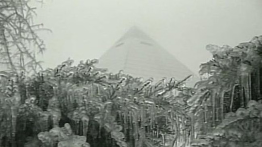
Image from: https://www.actionnews5.com/2019/02/11/breakdown-looking-back-ice-storm-feb/
Here is the surprise I have been working on for the last several weeks. This might be coming out a little late, but that has never hurt anything anyways. February 9th to February 11th marked the 30 year anniversary of the infamous 1994 Ice Storm that hit the region. I hope that everyone enjoys the blog and learns a little something about this event.
Introduction
The February 9th to 11th, 1994 Ice Storm will be always be consider one of the worst storms to ever impact North Mississippi, Arkansas, southwestern Tennessee and portions of Louisiana and northwestern Alabama. Widespread freezing rain accumulations of 2 to 6 inches had stretched from southern Arkansas and northern Louisiana into North Mississippi and eventually into Tennessee and northwestern Alabama. Due to the historic nature of this storm, I wanted to dive into the meteorological data from this event.
Synoptic Overview of the Event
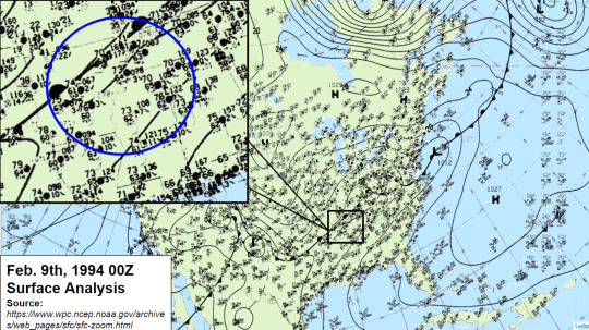
Before the storm, there was a stationary front stretching from southern Plains in Texas, into the Lower Ohio River Valley. Just to the south of that boundary, temperatures across the region were in the low to mid 70s across a large portion of Arkansas, Mississippi, Tennessee and even into northwestern Alabama. Towards Canada, there is an arctic High that was pushing the colder temperatures into the Central Plains and the upper Ohio River Valley, which eventually made its way into the Southeast.
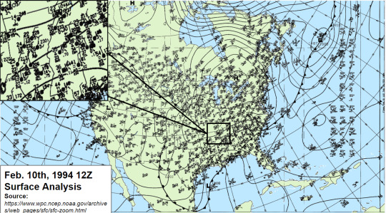
By 12z on February 10th, 1994, temperatures across the entire region had dropped to the mid 20s to the lower 30s within a 24 hour period as the stationary boundary had transition into a cold front causing the drastic drop in temperatures. By this time, the damage had been done as several places across Louisiana, Mississippi, Tennessee and Northwest Alabama had seen several inches of freezing rain. For those who did not see freezing rain, had to deal with flooding across the area where 5 to 7 inches of rain were reported.
Sounding Analysis for Little Rock and Memphis
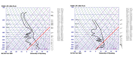
The first set of soundings show the drastic the temperature drop as the cold front had moved through the region on February 9th. The red line is the freezing mark for water at 32 F or 0 C. This was common across a large portion of the area.
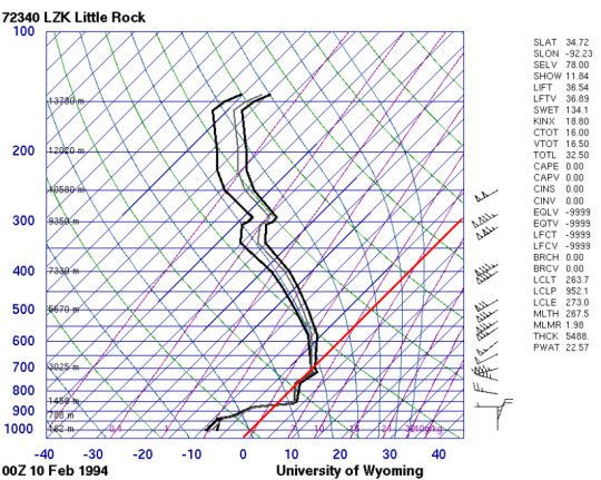
By 00z on February 10th, temperatures had fallen to below freezing and at this time. several places had ethier started or have been seeing freezing rain across the area. The freezing rain accumulation had continued for several hours after the fact at this point.

Image provided by the NOAA/ESRL Physical Sciences Laboratory, Boulder Colorado from their Web site at https://psl.noaa.gov/.
For comparison, this is the reanalysis sounding over Memphis, TN at 06z on February 10th, 1994 with the red line representing the freezing mark. Memphis, TN does not have an upper site like Little Rock or Jackson, MS, so a reanalysis can be use to provide what the atmosphere would have looked like given the meteorological conditions.
Estimated Precipitation Totals

As for the freezing rain totals, I was unable to get exact storm reports from this event. However, I was able to find estimated precipitation totals from the event. Given that freezing rain is measured very similar to rain, a 1:1 ration can be applied. This means for 1 inch of freezing rain, it is equal to 1 inch of rain. The black line is approximately where the separation of rain and freezing rain had occurred at between February 9th 12z to February 12th at 12z in 1994. Places north of the black line experienced freezing rain whereas places south of the line experienced heavy rainfall and possible flooding.

Source from: https://www.localmemphis.com/gallery/weather/severe-weather/ice-storm-memphis-mid-south-1994-greenville-mississippi/522-aeadd648-43b4-425e-a9e7-856dfc8f17c9
Several places in the Arkansas/Mississippi Delta had saw 3 to 5 inches of freezing rain, with some spots seeing closer to 6 inches. Across southern Tennessee, including the Memphis area, freezing rain accumulations of 2 to 3 inches were commonly seen or even reported for this event. Even in Alabama, several places in northwestern portion of the state saw 3 to 5 inches of freezing rain, if not more. For those who did not experience the Ice Storm of 1994, they did have to contend with flooding and heavy rainfall of upwards to 5 to 7 inches. Images, like the one above, were very common across the region.
0 notes
Text

Why I do not have anything to write weather wise at the moment, I am working on a side project. This side project will be posted when I am happy with the finished product. Btw, this project is still weather related.
Stay tuned for more!
0 notes
Text
Winter Weather: Precip Types

Since I have some down time, I figure this would be a great chance to discuss the different winter weather precipitation that everyone could see throughout the season. This blog will go into detail on the differences of each type and what makes them different from each other.
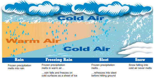
source: https://www.weather.gov/jan/winterweathersafety
Introduction
To start, there are four types of wintry precipitation that can occur at any given point in the atmosphere pending on temperature profile. These wintry weather precipitation type includes rain, sleet, snow and freezing rain. Notice that hail is not included since that is associated with severe thunderstorms and is developed by a slightly different process (will discuss this at a different time). The one thing that all the wintry precipitation types start off is snow, but that also depends on other factors that we will get to later on. As we looked at the graphic, the difference between the all the wintry precipitation types starts with the presence and depth of the warm layer. In order to determine this, requires a deeper analysis of the atmospheric profile with the use of skew-t diagrams or soundings.
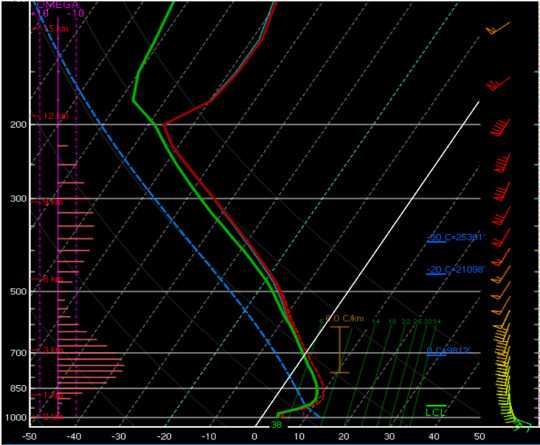
Skew-T diagram of a rain profile.
Rain
The first wintry precipitation that we will go over is rain. Unlike the other wintry precipitations, rain can be associated with thunderstorms and tropical systems. Rain can also occur during anytime of the year and is probably one the easiest precipitation types to forecast when it comes to winter weather. The white line in the skew-t diagram represent where the temperature being at 0 degrees Celsius (C) or 32 degrees Fahrenheit (F) which is the point where water freezes. In the skew-t diagram, temperatures from the surface to about 700 mb (3 km) in the atmosphere is entirely above freezing. With the combination surface temperatures being above freezing and a very deep warm layer, this will result in rain.

Skew-T diagram of a snow profile.
Snow
Heading into our next wintry precip type, this is not as easy to forecast when it comes to totals, but is very easily identifiable when analyzing the skew-t diagram. For snow, the entire atmospheric as to remain below freezing. Similar to the previous skew-t diagram, the white line represent where the freezing mark is located. In this case, the entire sounding remains below freezing which is an indicator for snow. However, that is only part of the equation for this. The other two factors are moisture and the snow growth zone (SGZ). If these two are not present, then snowfall could be severely limited. For the SGZ, temperatures between -12 degrees C to about -18 degrees C is consider sufficient for snow to developed. As for moisture, will prefer to see relative humidity values at 80% or greater. If the atmosphere becomes dry, then that could also alter the snowfall totals throughout the forecasting period. As for predicting snowfall ratios, I will not go into great detail, but will say that depends on depth of the SGZ, moisture, wind and local geography. All of these play a role into how determining snowfall ratios and why the 10:1 ratio is a poor indicator for snowfall totals.

Skew-T diagram of a sleet/freezing rain profile.
Sleet/Freezing Rain
For the last two, I am going to discuss them within the same section. The only difference between the two is dependent upon the depth of the warm layer. For sleet and freezing rain, these two are consider the worst of the wintry precipitation types of the group since they both contain ice. Between the two, sleet is better as sleet are ice pellets that will collect on the ground and will take longer before accumulating on trees and power lines.
For freezing rain, that is supercooled water that will freeze as it comes into contact with an object. The major issue with freezing rain is that it weights a lot heavier and does not take a lot to bring down tress and power lines. Freezing rain accumulations of 0.50" or more is major. Anything between 0.10' to 0.25" is considered significant. The other issue with freezing rain, and can be an issue with sleet as well, it makes traveling very difficult and hazardous as there is very little traction between the tires and the surface of the road.
Conclusions
I am hoping with these examples in mind, it proves not only a better insight on winter weather precipitation types and the differences between them. I am also hoping this provides more insight on why winter weather forecasting can be difficult as well. While the examples above were broken down individually, it is not uncommon to see some sort of combination of them.
3 notes
·
View notes
Text
Not so N-iCE !!!

The local National Weather Service Office in Memphis, TN has issued a Winter Weather Advisory that will go into effect Thursday morning at 6:00 AM to 7:00 PM Thursday evening. The advisory had been issued due to the potential for freezing rain.

Expect precipitation to move into the area late Thursday morning into the Thursday afternoon across the entire region. Temperatures will be hovering around the freezing mark across a large portion of the region. Precipitation is expected to move out of the area by late Thursday afternoon into Thursday evening. With the precipitation moving out quickly, accumulations will be limited for the Mid-South. Unfortunately, temperatures are expected to drop back to below freezing Thursday night into Friday morning allowing for the potential for black ice to develop on overpasses and elevated surfaces. Also, any snow that melts, it will also refreeze only enhancing the hazardous travel conditions for Thursday night into Friday morning.

Minor freezing rain accumulation will encompass majority of West Tennessee, southeastern Arkansas and a small portion of northern Mississippi (in yellow). Freezing rain accumulation within this area should will be a 0.10" or less. Again, this will only create more travel problems heading into Thursday night into Friday morning. The good news is that the freezing rain accumulations will not be a concern to power lines and tree limbs to the region.
01/17/2024 6:30 PM CST
0 notes
Text
Another One?

While I wish I had better news, but sadly I do not with this discussion as we head into the later part of the week. Continue to expect the deep freeze to stick around for the remainder of the week along with another round of wintry weather for Thursday which will be the main focus of this discussion.

Latest surface analysis shows majority of the Southeast United States remains under the influence of the arctic high that has brought extremely cold temperatures to the region. This arctic air mass will be here to stay well through the weekend. The good news is that there will be warming trend to begin early next week where we could see temperatures return to the mid to upper 40s across the Mid-South. Before getting all excited for next week, we will have to get through the second part of this week where some places will see another round of wintry precip on Thursday.

Model guidance shows a weak surface Low tracking through the southern Plains into southern Arkansas and northern Louisiana between Wednesday night into Thursday morning. The Low pressure will cause the return of not only southerly wind flow to the area, but also the return of moisture on Thursday.

Despite the return of moisture to the region, there will be only a small area of the Mid-South that will be impacted by this round of wintry precip. This round of wintry precip will begin around the lunch time hour and will last into Thursday evening.

As for the main precipitation type, I am expecting a sleet/freezing rain mix from the Mississippi/Tennessee state line and along I-40 (including the Memphis metro area). The good news with is that freezing rain/sleet accumulations should remain minor as totals will be around a tenth of an inch or less for a large portion of the region.
There is more uncertainty on seeing any freezing rain/sleet accumulations south of the Mississippi/Tennessee line as temperatures could remain just above freezing as this round moves which will result in a very cold rain shower in portions of northern Mississippi. However, temperatures will once again drop to below freezing and will remain that way through the weekend. This could result in black ice developing across the region and could cause some travel concerns on overpasses and elevated surfaces.
01/16/2024 8:55 PM CST
0 notes
Text
Snowfall Forecast for Jan 14th to Jan 15th, 2024

I wanted to get this out sooner but these are my final thoughts before the winter storm begin this evening. Model guidance finally gotten a better hold of where these heavier snow bands will occur at and who will see the most snow by Monday evening.
For the areas within the pink lines, widespread snowfall amounts up to 4" will be likely. There could be some localized areas of 6" to 8" of snow within this area as well, but that will depend heavily on the snow bands. Those on the northern side and southern side of the pink lines could see less pending on exactly where the heavier bands will settle at, especially south of US HWY 278, where a dusting is expected.

Comparing the 18z HRRR data that has just came out (without the pink lines), it appears that the potential of 6 to 8" will still exist mainly along the TN/MS stateline to I-40. However, there is not much of a difference other than the increase potential of the higher snowfall amounts.
01/14/2024 2:00 PM CST
0 notes
Text
Snow Call
For the discussion regarding the winter storm, it will focus on what to expect in terms of snowfall accumulations across the region and timing. This discussion will also be on the shorter side since it will be focus on those two items.

For starters, there is a winter storm warning (in pink) for a large portion of Arkansas, West Tennessee, and North Mississippi until 6:OO PM CST Monday evening. For places in eastern Texas, northern Louisiana and western Arkansas, the winter storm warning be valid until Monday morning at 6:00 AM CST.

Several places within the winter weather advisories, watches and warnings could start seeing wintry precip as early as Sunday evening as the plume of moisture meets the cold arctic air mass tomorrow evening and should last into Monday afternoon into Monday evening. Several places across the area will already be below freezing and will remain below freezing which will allow for snow to accumulate rapidly throughout the period.

While there are some uncertainties in exactly where the heavier snow will occur, model guidance does show a wide swath of 4 to 6 inches of snow possible along I-40, which includes the city of Memphis and Jackson, TN. There is the possibility that within this region, some places could potentially push snowfall totals closer to 8 inches. While this is not set in stone, this is something to be on the lookout for. For those outside this area, should expect 2 to 4 inches of snow. Those in northern Mississippi, the accumulating snow will extend as far south as Tupelo, MS into Cleveland, MS. Places south of that line, could expect a dusting to maybe an inch of snow by the time it is all said and over with.
Ice/freezing rain will not be a major concern with this event, which is a good thing. Ice/freezing rain weighs heavier than snow which means it does not take a lot to cause trees and powerlines to be damage or broken off either.
01/13/2024 7:00 PM CST
0 notes
Text
Say S-No-w More
With the potential for significant snowfall within the forecast for Sunday night into Monday morning, I want to take some time to discuss the timing and what to expect in terms of snowfall acclamations. Please note that winter weather forecasting is extremely difficult to forecast and subject to change with new data that comes in.
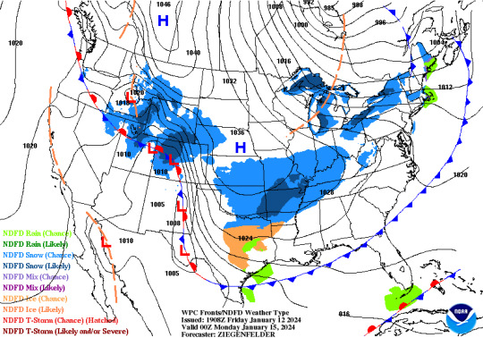
Beginning Sunday evening, a cold arctic airmass will be pushing through the Central and Southeast United States. With this cold airmass will be a 1036 mb arctic high being located over the northern Plains. With this high pressure settling over the northern Plains, extremely cold air will be pushing as far south as Texas, Louisiana, Mississippi, and Alabama. In combination of the cold air and High pressure system, there will be cold front that will be stretching from the Gulf of Mexico into the Northeast United States. With these two features, there will be a plume of moisture that will be wedged in between the two allowing the potential for widespread snowfall across Missouri, Arkansas, West Tennessee, and northern Mississippi.

Timing of the precipitation will begin late Sunday evening and will continue into Monday afternoon across a large portion of West Tennessee, North Mississippi, Arkansas and Missouri, where temperatures will be below freezing for the majority of the event and will remain below freezing in the following days after. Across northern Texas into Texarkana region , they will see mostly mix of freezing rain and/or sleet for much of this time period as there will be a warm layer within the boundary layer allowing the development of sleet or freezing rain to occur. This area of freezing rain and sleet will likely extend into portions of southern Arkansas into northern Louisiana by Monday morning and eventually into portions of Central Mississippi by Monday evening. Total ice accumulations are expected to be focus in Texas, Arkansas and portions of northern Louisiana. In Central Mississippi, there is a little more uncertainty on how much and exactly where ice will accumulate.
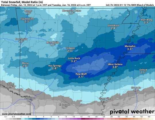
As for snowfall, this is the area where snowfall accumulations are expected to be higher. Again this is subject to change as new model data comes and the higher resolution models become available. While a lot of the model guidance has been back and forth with the amounts, it is not unreasonable to think widespread 2 to 4 inches of snow will occur across this area. While it is not set stone, the higher snowfall amounts will be focus along I-40 and north. Places further south, especially those closer to the wintry mix zone or even the sleet/freezing line mark should expect lower snowfall accumulations. The trend in the recent model data is for the heavier snowband to set up along I-40. This is not for certain as model guidance has been struggling with this placement of this for the last couple of days.
As a reminder, this forecast is subject to change base off new data as they come in, especially when it comes to snow and ice accumulations. While I did not discuss in great detail, expect cold temperatures across a large portion of the southern United States and expect them to say for a good portion of the week.
01/12/2024 6:30 PM CST
0 notes
Text
Late Thursday Night into Friday WX Discussion

With the next Low pressure moving through the region, there will be another round of severe weather that will begin tonight and will continue into tomorrow with both regions having an enhance risk of severe weather across their respective regions. This discussion will go over the timings and the main threats for each region. For those in the severe weather risk, take all weather watches, warnings and other alerts seriously. For those going to bed, be sure to have multiple ways to receive warnings in the event one is issue.

Focusing over the Texarkana region first, there is an enhance risk of severe weather that extends from southern Arkansas and stretches down towards northeastern Texas and portions of northwestern Louisiana. Storms will begin to develop around around 6 to 9 PM CST across western Arkansas in the warm sector. This cluster of storms continue to develop into a larger multicell system before being push off towards the northeast. Behind the multicell cluster, is another line of storms that will be associated with the cold front as it begins to make the eastward progression into the Texarkana region. This second line of storms will contain the main severe weather threat for the overnight period.

This second line of storms will have developed and begin pushing through the region between 3 to 6 AM CST Friday morning. As seen in the image above, there will be isolated discrete cells out of ahead of the mainline which could become problematic if they are able to sustained themselves. Model guidance shows the storm environment being conducive for severe storms. However, that window of favorable support will be small as there will limited destabilization across the region.

In terms of what to expect for the region, tornadoes, damaging winds and hail will be possible. Forecast soundings show instability being around 900 J/kg to 1,200 J/kg with a veering wind profile which supports the potential for tornadic storms. PW values around 1.0 to 1.2 inches will also sufficient enough to potentially produce hai. Anything exceeding 1.5 inches of PW will cause the hailstorms to become water loading. Damaging winds will also be possible as the low level jet will be present of 50 to even 60 knots. If those winds are able to mix down to the surface, it could enhance the damaging wind threat across the region. These storms are expected to move out of the region by Friday morning around 6 to 7 AM CST Friday morning.

Shifting into Friday where the severe weather threat will still be a concern across northern Mississippi into portions of western Alabama. Since the storms are expected to arrive by late morning into the early afternoon, daytime heating will be severely limited along with the expected cloud coverage across the region.

Despite the limited daytime heating, there will remain a small window for storms to become severe between 9 AM to 12 PM CST where model guidance shows a very thin area of instability of about 600 to 800 J/kg across the region. The only issue is there will be some discrete storms within this region ahead of the line that could interfere with the limited instability available.

While that maybe the case, the environment does show the support of not only damaging winds, but potential for tornadic storms as well. I do not expect tomorrow to be a major tornadic day as the environment does not support that, but could see some isolated tornadoes across northern Mississippi into western Alabama. The bigger concern going into Friday will be the damaging winds as the low level jet is expected to strengthen and contain winds of 60 to 70 knots. Similar to the Texarkana, if any of those winds are able to mix down to the surface, it will be a long day for those in the region. As for the hail threat, not as concern with that as PW values will be closer to the 1.5 inch value and water loading will become a bigger concern in combination of the weaker instability values across the region.
01/11/2024 5:30 PM CST
0 notes
Text
Round 2 Fight!!!
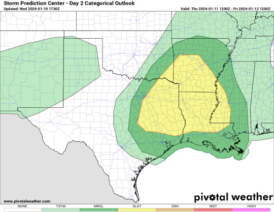
Figure 1. SPC Day 2 (Thurs.) Outlook
Looks like we will be fighting another Low pressure system later this week into the early part of the weekend. This discussion will be focus on the second Low pressure system that is expected to bring another round of severe weather into the region heading into Thursday night into Friday morning. The Storm Prediction Center (SPC) has a slight risk of severe weather covering East Texas into the Mississippi Delta for Thursday night.

Figure 2. SPC Day 3 (Friday) Outlook
Since the severe weather threat will exist well into Friday morning, the SPC also highlighted Central Mississippi into the Carolinas under the slight risk of severe weather, while portions of Alabama, Georgia and into North Carolina are in the enhance risk of severe weather heading into Friday as well.

For Thursday afternoon, wind direction will out of the south to southeast across a large portion of the severe weather risk with temperatures in the mid 50s to lower 60s across the area. Places further south and to the east, like in Texas or Louisiana could see temperatures in the mid 60s to the lower 70s by sunset where there could be influence by the Gulf waters.
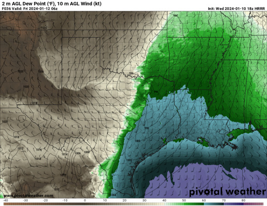
After sunset, temperatures will begin to drop slightly, however, temperatures should remain in the low to mid 60s across Texas, Louisiana and Mississippi outhead of the cold front. As for dew points, those will remain in the upper 50s to lower 60s across the entire region during the overnight hours. Typically, both temperature and dew point should be in to the mid to upper 70s as that provides both moisture and unstable air mass. Given that we are in the middle of winter, temperatures in the 60s still can be enough, especially if there is enough lift in the atmosphere, which there will be.

Since the timing of the storms will be during the overnight and early timeframe, there will be limited amount of destabilization that will occur. This limited destabilization has to do with the combination of time of year and time of day. Unfortunately, there will still be enough energy for storms to feed off, as seen in Florida earlier this week. Instability (energy) values will range from 600 J/kg to under 1,000 J/kg. There could also be localized areas that could see values breaching 1,000 J/kg threshold. Anything under 1,000 J/kg is considered low-cape environments and this is normal for this part of the region regardless.

Going a little deeper into the data, forecast soundings across the severe weather risk shows support not only for severe weather but also tornadic storms with the veering wind profile and looping hodograph (suggesting directional shear present). SRH values are in the 400 to 500s which means these storms will have the potential to spin and could enhance the tornado threat within the line. As for the damaging wind potential, there is not only a massive dry pocket within the sounding, but also there will be strong low-level jet present. If the winds from the low-level jet are able to mix down to the surface, then we could see some severe winds embedded within the storms. As for the hail threat, that will remain low as the as there is marginally favorable instability present and PW values could exceed 1.25 inches causing the hailstones to become waterlog and melt, but this not a guarantee.

In terms of storm mode and timing, expect the storms to begin to develop over eastern Texas into southern Arkansas late Thursday night as a small cluster. Around midnight Friday, the storms will have developed into a linear model with some discrete cells out of mainline. This line of storms will continue to push the through region into the early Friday morning. The line of storms should be out of the area before lunch time Friday. The only thing that the area may have to contend with is another windy day where wind gust of 30 to 50 mph could be possible for the entire region after the passage of the cold front.
01/10/2024 5:35 PM CST
0 notes