#icesat-2
Explore tagged Tumblr posts
Visit Tumblr Blog
Explore Tumblr blogs with no restrictions, modern design and the best experience.
Last Seen Tumblr Blogs


Fun Fact
Mobile Tumblr US users spend an average of 4.04 minutes per session on the app.
Text
ICESat-2 Hosts Third Applications Workshop
Introduction The NASA Ice, Cloud, and land Elevation Satellite-2 mission (ICESat-2), launched September 15, 2018, continues the first ICESat mission, delivering invaluable global altimetry data. Notwithstanding its icy acronym, ICESat-2 can do more than measure ice – in fact, the expanded acronym hints at these wider applications. From vegetation to inland surface water to bathymetry, […] from NASA https://ift.tt/6klCFzc
0 notes
Text


ESA and NASA satellites deliver first joint picture of Greenland Ice Sheet melting
Academics from Northumbria University are part of an international research team which has used data from satellites to track changes in the thickness of the Greenland Ice Sheet.
Academics from Northumbria University are part of an international research team which has used data from satellites to track changes in the thickness of the Greenland Ice Sheet.
Global warming is causing the Ice Sheet to melt and flow more rapidly, raising sea levels and disturbing weather patterns across our planet.
Because of this, precise measurements of its changing shape are of critical importance for tracking and adapting to the effects of climate warming.
Scientists have now delivered the first measurements of Greenland Ice Sheet thickness change using CryoSat-2 and ICESat-2 – the ESA and NASA ice satellite missions.
Both satellites carry altimeters as their primary sensor, but they make use of different technologies to collect their measurements.
CryoSat-2 carries a radar system to determine the Earth’s surface height, while ICESat-2 has a laser system for the same task.
Although radar signals can pass through clouds, they also penetrate into the ice sheet surface and have to be adjusted for this effect.
Laser signals, on the other hand, reflect from the actual surface, but they cannot operate when clouds are present.
The missions are therefore highly complementary, and combining their measurements has been a holy grail for polar science.
A new study from scientists at the UK Centre for Polar Observation and Modelling (CPOM), based at Northumbria University, and published in Geophysical Research Letters shows that CryoSat-2 and ICESat-2 measurements of Greenland Ice Sheet elevation change agree to within 3%.
This confirms that the satellites can be combined to produce a more reliable estimate of ice loss than either could achieve alone. It also means that if one mission were to fail, the other could be relied upon to maintain our record of polar ice change.
Between 2010 and 2023, the Greenland Ice Sheet thinned by 1.2 metres on average. However, thinning across the ice sheet’s margin (the ablation zone) was over five times larger, amounting to 6.4 metres on average.
The most extreme thinning occurred at the ice sheets outlet glaciers, many of which are speeding up.
At Sermeq Kujalleq in west central Greenland (also known as Jakobshavn Isbræ), peak thinning was 67 metres, and at Zachariae Isstrøm in the northeast peak thinning was 75 metres.
Altogether, the ice sheet shrank by 2,347 cubic kilometres across the 13-year survey period – enough to fill Africa’s Lake Victoria.
The biggest changes occurred in 2012 and 2019 when summer temperatures were extremely hot and the ice sheet lost more than 400 cubic kilometres of its volume each year.
Greenland’s ice melting also affects global ocean circulation and disturbs weather patterns. These changes have far-reaching impacts on ecosystems and communities worldwide.
The availability of accurate, up-to-date data on ice sheet changes will be critical in helping us to prepare for and adapt to the impacts of climate change.
Lead author and CPOM researcher Nitin Ravinder said: “We are very excited to have discovered that CryoSat-2 and ICESat-2 are in such close agreement.
“Their complementary nature provides a strong motivation to combine the data sets to produce improved estimates of ice sheet volume and mass changes.
“As ice sheet mass loss is a key contributor to global sea level rise, this is incredibly useful for the scientific community and policymakers.”
The study made use of four years of measurements from both missions, including those collected during the Cryo2ice campaign, a pioneering ESA-NASA partnership initiated in 2020.
By adjusting CryoSat-2’s orbit to synchronise with ICESat-2, ESA enabled the near-simultaneous collection of radar and laser data over the same regions.
This alignment allows scientists to measure snow depth from space, offering unprecedented accuracy in tracking sea and land ice thickness.
Tommaso Parrinello, CryoSat Mission Manager at ESA, expressed optimism about the campaign’s impact:
“CryoSat has provided an invaluable platform for understanding our planet’s ice coverage over the past 14 years, but by aligning our data with ICESat-2, we’ve opened new avenues for precision and insight.
“This collaboration represents an exciting step forward, not just in terms of technology but in how we can better serve scientists and policymakers who rely on our data to understand and mitigate climate impacts.”
Thorsten Markus, project scientist for the ICESat-2 mission at NASA, said: “It is great to see that the data from ‘sister missions’ are providing a consistent picture of the changes going on in Greenland.
“Understanding the similarities and differences between radar and lidar ice sheet height measurements allows us to fully exploit the complementary nature of those satellite missions.
“Studies like this are critical to put a comprehensive time series of the ICESat, CryoSat-2, ICESat-2, and, in the future, CRISTAL missions together.”
ESA’s CryoSat-2 continues to be instrumental in our understanding of climate related changes in polar ice, working alongside NASA’s ICESat-2 to provide robust, accurate data on ice sheet changes.
Together, these missions represent a significant step forward in monitoring polar ice loss and preparing for its global consequences.
CPOM is a partnership of six universities and the British Antarctic Survey (BAS), based at Northumbria University, primarily funded by the National Environment Research Council (NERC) to provide national capability in observation and modelling of the processes that occur in the Polar regions of the Earth.
CPOM uses satellite observations to monitor change in the Polar regions and numerical models to better predict how their ice and oceans might evolve in the future.
By providing long-term capabilities to the scientific community and leading international assessments, CPOM helps global policymakers plan for the effects of climate change and sea level rise.
IMAGE: Greenland Ice Sheet Credit Prof Andrew Shepherd
6 notes
·
View notes
Note
.HELLOOO it's chipsat again. i guess for canontroductions i'm gonna call ice out.
.literally the first thing i ever heard from icesat was "me, my sister, and my sister's manifestation of crushing guilt." which???? VERY jarring to hear from someone who as far as you were aware did not exist lol. what is his problem (/affectionate)
- chipsat, noncanon 17776 fictive, #🧡🍄
2
4 notes
·
View notes
Note
What’s your opinion on these guys ? I wanna know if I’m not the only one >///<


The top is the ICESat-2 Satellite, the bottom is the Opportunity Rover. Both are from NASA ^w^ ~
very cute lil guys. my heart aches for opportunity rover
8 notes
·
View notes
Note
SO SO SO glad Jaiden made it in. thank you, mx split, for allowing OCs because i am ECSTATIC seeing her here
i forget what i actually put as propaganda when i submitted her but like. she absolutely sucks. shes so interesting. there is so much wrong with her. she used to be a nurse before humans stopped being able to die of natural causes and one day SPACE PROBES started waking up and yknow. being People and so JAIDEN decided "hey what if i tried waking one up myself" and proceeded to. try doing that for awhile and, in her own words (this was written by her mun, Rusty): > "None of the machines had survived so far. But all of them were worthy sacrifices in her eyes. If they did not survive, they would have contributed to the next machine’s progress. Each failed subject was a lesson for the woman, a lesson of what not to do next time."
So she's a little fucked up. Anyways one day she finally manages to wake Chip up successfully and. uh. Well she succeeded at that! She doesn't tell Chip her actual name, saying he can give her one instead and so thats where she gets the alias "Dani" from
Anyways. I'm not going to attempt to sum up every event involving her ever cause we'd be here all day, but some major points include: 1 - Emotional manipulation 2 - At one point, hacking of MULTIPLE sentient probes (icesat-1, MESSENGER, and.. C h i p) 3 - The entire arc with her and Chip. Hey isnt it fun when somebody gives themselves up for everyone? Isnt it fun when somebody puts their life in the hands of someone else, says to do anything - dissect them, burn them up in the atmosphere, whatever, just stop hurting their friends (Colors added to make intent clear here: green is dani, red is chip) When their sibling learns what they did and is forced to watch as they experience frequent overheating and memory lapses When she's finally gone, but what she did has left a lasting impact and sure they can try to stay silly but now theyre haunted by the memory of someone who loved them. someone who hurt them. jesus christ. yeah shes fucked up
Anyways check the reblogs on the Jaiden poll if you want to see a video mimi made with her in it!
.
6 notes
·
View notes
Link
Anthropogenic climate change is creating a vicious circle where rising temperatures are causing glaciers to melt at an increasing rate. In addition to contributing to rising sea levels, coastal flooding, and extreme weather, the loss of polar ice and glaciers is causing Earth’s oceans to absorb more solar radiation. The loss of glaciers is also depleting regional freshwater resources, leading to elevated levels of drought and the risk of famine. According to new findings by an international research effort, there has been an alarming increase in the rate of glacier loss over the last ten years. The research was conducted by the Glacier Mass Balance Intercomparison Exercise (GlaMBIE) team, a major research initiative coordinated by the World Glacier Monitoring Service (WGMS). Located at the University of Zurich in collaboration with the University of Edinburgh and Earthwave Ltd, this international data repository and data analyzing service generates community estimates of glacier mass loss globally. The paper that details their research and findings, “Community estimate of global glacier mass changes from 2000 to 2023,” was published on February 19th in the journal Nature. As part of their efforts, the team coordinated the compilation, standardization, and analysis of field measurements and data from optical, radar, laser, and gravimetry satellite missions. These include satellite observations from NASA’s Terra Advanced Spaceborne Thermal Emission and Reflection Radiometer (ASTER) and Ice, Cloud, and Land Elevation Satellite-2 (ICESat-2), the NASA-DLR Gravity Recovery and Climate Experiment (Grace), the GLR’s TanDEM-X mission, and the ESA’s CryoSat missions, and more. Combining data from multiple sources, the Glambie team produced an annual time series of global glacier loss from 2000 to 2023. In 2000, glaciers covered about 705,221 square km (272,287 mi2) and held an estimated 121,728 billion metric tons (134,182 US tons) of ice. Over the next twenty years, they lost 273 billion tonnes of ice annually, approximately 5% of their total volume, with regional losses ranging from 2% in the Antarctic and Subantarctic to 39% in Central Europe. To put that in perspective, this amounts to what the entire global population consumes in 30 years. In short, the amount of ice lost rose to 36% during the second half of the study (2012 and 2023) compared to the first half (2000-2011). Glacier mass loss over the whole study period was 18% higher than the meltwater from the Greenland Ice Sheet and more than double that from the Antarctic Ice Sheet. Michael Zemp, a noted glaciologist who co-led the study, said in an ESA press release: “We compiled 233 estimates of regional glacier mass change from about 450 data contributors organized in 35 research teams. Benefiting from the different observation methods, Glambie not only provides new insights into regional trends and year-to-year variability, but we could also identify differences among observation methods. This means that we can provide a new observational baseline for future studies on the impact of glacier melt on regional water availability and global sea-level rise.” This photograph, taken in 2012, shows the Golubin Glacier in Kyrgyzstan, in Central Asia. Credit: M. Hoelzle (2012) Globally, glaciers collectively lost 6,542 tonnes (7,210 tons) of ice, leading to a global sea-level rise of 18 mm (0.7 inches). However, the rate of glacier ice loss increased significantly from 231 billion tonnes per year in the first half of the study period to 314 billion tonnes per year in the second half – an increase of 36%. This rise in water loss has made glaciers the second-largest contributor to global sea-level rise, surpassing the contributions of the Greenland Ice Sheet, Antarctic Ice Sheet, and changes in land water storage. Said UZH glaciologist Inés Dussaillant, who was involved in the Glambie analyses: “Glaciers are vital freshwater resources, especially for local communities in Central Asia and the Central Andes, where glaciers dominate runoff during warm and dry seasons. But when it comes to sea-level rise, the Arctic and Antarctic regions, with their much larger glacier areas, are the key players. However, almost Thione-quarter of the glacier contribution to sea-level rise originates from Alaska.” These results will provide environmental scientists with a refined baseline for interpreting observational differences arising from different methods and for calibrating models. They hope this will help future studies of global ice loss by narrowing the projection uncertainties for the twenty-first century. These research findings are the culmination of many years of cooperative studies and observations, which included the use of satellites that were not specifically designed to monitor glaciers globally. As co-author Noel Gourmelen, a lecturer in Earth Observation of the Cryosphere at the University of Edinburgh, said: “The research is the result of sustained efforts by the community and by space agencies over many years, to exploit a variety of satellites that were not initially specifically designed for the task of monitoring glaciers globally. This legacy is already producing impact with satellite missions being designed to allow operational monitoring of future glacier evolution, such as Europe’s Copernicus CRISTAL mission which builds on the legacy of ESA’s CryoSat.” The study also marks an important milestone since it was released in time for the United Nations’ International Year of Glaciers’ Preservation and the Decade of Action for Cryospheric Sciences (2025–2034). Said Livia Jakob, the Chief Scientific Officer & Co-Founder at Earthwave, hosted a large workshop with all the participants to discuss the findings. “Bringing together so many different research teams from across the globe in a joint effort to increase our understanding and certainty of glacier ice loss has been extremely valuable. This initiative has also fostered a stronger sense of collaboration within the community.” The study also illustrates the importance of collective action on climate change, which is accelerating at an alarming rate. Research that quantifies glacial loss, rising sea levels, and other impacts is key to preparing for the worst. It’s also essential to the development of proper adaptation, mitigation, and restoration strategies consistent with the recommendations made by the UN Intergovernmental Panel on Climate Change (IPCC). Further Reading: ESA The post Glaciers Worldwide are Melting Faster Causing Sea Levels to Rise More appeared first on Universe Today.
0 notes
Text
Un estudio internacional revela que los glaciares han perdido un 5 % de su volumen total en los últimos 20 años. En la última década, la velocidad de deshielo ha aumentado un 36 %. Glaciares en las montañas Chugach de Alaska. Imagen de Copernicus Sentinel-2 del 6 de octubre de 2017, que muestra el deshielo de los glaciares Scott, Sheridan y Childs alimentando lagos y ríos. / Copernicus Sentinel / ESA Los glaciares de todo el mundo han perdido en las últimas dos décadas más de 6.500 billones de toneladas de hielo, lo que ha reducido los recursos regionales de agua dulce y ha contribuido al aumento del nivel del mar. Según un estudio publicado en Nature, la pérdida anual promedio ha sido de 273.000 millones de toneladas, aunque en la última década la velocidad del deshielo se ha incrementado un 36 %. Dentro de esa media “se esconde un alarmante aumento en los últimos 10 años”, indica la Agencia Espacial Europea (ESA). “Recopilamos 233 estimaciones del cambio de masa de los glaciares regionales a partir de unos 450 investigadores que participaron en 35 equipos de investigación”, explica Michael Zemp, de la Universidad de Zúrich y codirector del estudio. Los vigilantes del los glaciares La investigación se realizó dentro del Ejercicio de Intercomparación de Balances de Masa de Glaciares (Glambie), una iniciativa coordinada por el Servicio Mundial de Vigilancia de Glaciares (WGMS). Los resultados muestran que en el año 2000 los glaciares, excluyendo las capas de hielo de Groenlandia y la Antártida, abarcaban 705.221 kilómetros cuadrados y contenían aproximadamente 121.728 millones de toneladas de hielo. Desde entonces han perdido un 5 % de su volumen, con reducciones que varían entre un 2 % en las islas antárticas y subantárticas y un 39 % en Europa Central. Riesgo para ecosistemas y personas Las consecuencias del retroceso glaciar afectan tanto a los ecosistemas como a las comunidades humanas. “Los glaciares son recursos vitales de agua dulce, especialmente para las poblaciones de Asia Central y los Andes Centrales, donde dominan la escorrentía en estaciones cálidas y secas”, destaca Inés Dussaillant, investigadora de WGMS y coautora del estudio. La pérdida de hielo también repercute en el aumento del nivel del mar. Actualmente, los glaciares son el segundo mayor contribuyente al ascenso del nivel del mar, después de la expansión térmica de los océanos. En total, la pérdida de hielo registrada entre 2000 y 2023 ha provocado un incremento de 18 milímetros en el nivel del mar, con una media anual de 0,75 milímetros. El estudio se basó en datos de múltiples misiones satelitales, incluyendo Terra/ASTER e ICESat-2 (EE UU), GRACE (EE UU-Alemania), TanDEM-X (Alemania) y CryoSat (Agencia Espacial Europea). “Gracias a la combinación de distintos métodos de observación, no solo hemos identificado tendencias regionales, sino también diferencias entre los sistemas de medición”, indicó Zemp. El equipo de investigación destacó la importancia de continuar el monitoreo de los glaciares mediante satélites diseñados específicamente para esta tarea, como la futura misión europea Copernicus CRISTAL. “Estos hallazgos proporcionan una base clave para futuras investigaciones sobre la disponibilidad de agua dulce y el impacto del deshielo en el nivel del mar”, concluye Stephen Plummer, científico de la ESA. Fuente: ESA /EFE

View On WordPress
0 notes
Text
Disturbing time-lapse captures 563 cubic miles of ice vanishing from Greenland
0 notes
Text
Laser Scanning: An In-Depth Guide to the Technology, Its Types, and Importance

Laser scanning is a revolutionary technology that enables the precise measurement and mapping of objects, environments, and surfaces by using laser beams. It plays a key role in a wide variety of fields, such as architecture, engineering, construction, environmental science, archaeology, and even filmmaking. This technology works by emitting laser beams from a scanner, which reflect off surfaces, with the time it takes for the light to return being recorded. This data is then used to generate accurate, detailed 3D models or maps. In this article, we will explore the concept of laser scanning, the different types of laser scanning, and its importance across industries. What Is Laser Scanning? Laser scanning, often referred to as LiDAR (Light Detection and Ranging) or 3D scanning, is a technique that utilizes laser beams to collect data points from the surface of objects. These data points represent the distance between the scanner and the object, calculated based on the time it takes for the laser to hit the object and reflect. This results in a "point cloud," which is essentially a collection of millions of data points that can be processed to create a precise 3D digital model. The primary advantage of laser scanning is its ability to capture complex geometries and large environments with a high degree of accuracy and detail in a relatively short amount of time. Compared to traditional measurement methods, laser scanning can be exponentially faster while also reducing human error. Types of Laser Scanning There are three main types of laser scanning technologies: satellite laser scanning, airborne laser scanning, and terrestrial laser scanning. Each type serves a unique purpose depending on the scope and the area that needs to be scanned. 1. Satellite Laser Scanning Satellite laser scanning, also known as spaceborne laser scanning, involves lasers mounted on satellites orbiting the Earth. These lasers are used to measure the Earth’s surface and can map large-scale environments, from vast landscapes to urban areas. This technology has become instrumental in climate studies, topography, forest management, and disaster response. Applications of Satellite Laser Scanning: - Climate Change and Environmental Monitoring: Satellite laser scanning helps scientists monitor deforestation, glacier movements, and sea-level changes. By comparing scans taken over time, researchers can observe environmental changes on a global scale, making this an essential tool for studying climate change. - Urban Planning and Development: The ability to collect data on cities and urban areas from space allows for large-scale infrastructure planning and population growth studies. - Disaster Management: Satellite laser scanning can be used to assess damage caused by natural disasters such as earthquakes, floods, and hurricanes. It provides real-time data for emergency responses and recovery planning. One of the best-known examples of this technology is NASA’s ICESat-2 (Ice, Cloud, and Land Elevation Satellite), which measures ice sheet elevations, forest canopy heights, and more. 2. Airborne Laser Scanning Airborne laser scanning, often referred to as LiDAR when applied in this context, is performed by mounting a laser scanner on an aircraft, helicopter, or drone. As the aircraft flies over a target area, the laser scanner emits thousands of laser pulses per second towards the ground. These pulses then reflect to the scanner, and the time-of-flight (ToF) is used to calculate distances, which can be converted into topographical maps or 3D models. Applications of Airborne Laser Scanning: - Geographical Information Systems (GIS): Airborne laser scanning is widely used in GIS to generate accurate digital elevation models (DEMs) and 3D topographical maps. This data is crucial for floodplain mapping, land-use planning, and environmental conservation. - Forestry Management: LiDAR is used to analyze forest structures by calculating tree heights, canopy density, and forest biomass. This helps in forest monitoring, resource management, and wildfire risk assessment. - Infrastructure and Urban Mapping: Municipalities use airborne laser scanning to map cities and urban regions, helping with planning for new infrastructure projects, monitoring traffic patterns, and managing utilities. One advantage of airborne scanning is its ability to cover vast areas quickly, making it ideal for surveying inaccessible regions such as dense forests, mountains, and large river systems. 3. Terrestrial Laser Scanning Terrestrial laser scanning involves the use of stationary ground-based scanners that are typically mounted on tripods or other platforms. These scanners rotate around a fixed point and capture the environment in 360 degrees. Unlike airborne or satellite scanning, terrestrial laser scanning provides highly detailed and accurate scans of objects within a smaller range. Applications of Terrestrial Laser Scanning: - Architecture and Construction: Terrestrial laser scanning is widely used in the construction industry for surveying buildings, bridges, and other infrastructure. Scans can help identify structural issues, monitor progress, and create precise as-built models. - Heritage Preservation: This technology is often used to create digital replicas of historical monuments, ancient buildings, and archaeological sites. These digital replicas help preserve and restore cultural heritage. - Industrial Inspections: Terrestrial laser scanning is used to inspect manufacturing facilities, pipelines, and machinery. It allows engineers to detect potential wear and tear or damage, making maintenance more efficient. The detailed and accurate data provided by terrestrial laser scanning is essential for professionals working in fields that require precise measurements, such as civil engineering, architecture, and construction. The Importance of Laser Scanning Laser scanning has become an invaluable tool in modern industries due to its unparalleled precision, speed, and versatility. Below are some key reasons why laser scanning is important: 1. High Accuracy and Precision Laser scanning produces data with a level of accuracy that traditional surveying methods cannot match. The technology can capture details down to millimeter-level precision, making it ideal for industries where even the smallest measurement errors can have significant consequences, such as construction, engineering, and manufacturing. 2. Time-Efficiency Laser scanning drastically reduces the amount of time needed for surveying and data collection. Traditional surveying techniques may take days or weeks to complete large-scale projects, whereas laser scanning can collect data in hours. This saves time and resources, allowing projects to be completed faster. 3. Comprehensive Data Collection Laser scanning captures millions of data points in a short period, resulting in a highly detailed point cloud that can be processed into a 3D model or map. These models are not only accurate but also rich in detail, providing comprehensive information that can be analyzed and manipulated for various purposes. 4. Non-Contact Measurement Laser scanning is a non-invasive technology, which means there is no need for physical contact with the object being scanned. This is particularly useful when working with delicate or hazardous materials, such as historical artefacts, contaminated areas, or dangerous construction sites. 5. Versatility Across Multiple Industries Laser scanning is versatile enough to be used in a wide range of industries, including: - Construction: For as-built models and progress tracking. - Archaeology: To digitally preserve and analyze historical sites. - Automotive and Aerospace: To inspect components and detect manufacturing defects. - Environmental Science: To monitor natural ecosystems and study changes in landscapes. - Healthcare: For creating accurate prosthetics and detailed imaging of the human body. Conclusion Laser scanning is an essential technology that is transforming the way we measure, map, and analyze the world around us. With its ability to generate highly accurate 3D models in a fraction of the time required by traditional methods, it has found applications in numerous industries, from construction and environmental monitoring to archaeology and industrial inspections. The future of laser scanning looks even more promising with the continued advancement of the technology. As laser scanning becomes more affordable and accessible, its potential applications are expected to expand, bringing unprecedented precision and efficiency to various fields. Whether you’re planning a new infrastructure project, preserving a historical site, or conducting environmental studies, laser scanning is likely to play a critical role in your work. Read the full article
0 notes
Text
Bente Eegholm: Ensuring Space Telescopes Have Stellar Vision - NASA
New Post has been published on https://sunalei.org/news/bente-eegholm-ensuring-space-telescopes-have-stellar-vision-nasa/
Bente Eegholm: Ensuring Space Telescopes Have Stellar Vision - NASA
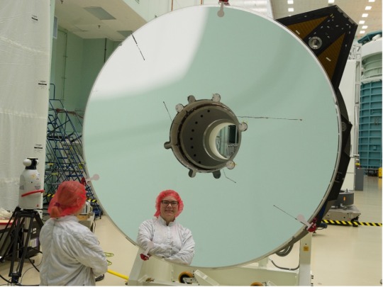
Bente Eegholm is an optical engineer working to ensure missions like the Nancy Grace Roman Space Telescope have stellar vision. When it launches by May 2027, the Roman mission will shed light on many astrophysics topics, like dark energy, which are currently shrouded in mystery. Bente’s past work has included Earth-observing missions and the James Webb Space Telescope.
Name: Bente Eegholm Title: Goddard Optics Lead for Roman Space Telescope OTA (Optical Telescope Assembly) Formal Job Classification: Optical Engineer Organization: Optics Branch (Code 551)
What do you do and what is most interesting about your role at Goddard?
I am an optical engineer, and I work on the Nancy Grace Roman Space Telescope as the Goddard optics lead on the observatory’s OTA (Optical Telescope Assembly). My work is a combination of optical systems work, technical meetings, and hands-on work in the labs and integration facilities. The most interesting part is that we are creating unique, one-of-a-kind instruments, which enable NASA, as well as anyone around the world, to become more knowledgeable about our universe, including our own planet.
How will your current work influence the Nancy Grace Roman Space Telescope’s future observations?
The quality of Roman’s future observations is directly tied to the telescope’s optical quality. As an optical engineer I am involved with providing the best imaging possible for the telescope and its science instruments. I work closely with the OTA management, and optical and system engineers at Goddard and at L3Harris in Rochester, New York, a mission partner that is building the OTA. The OTA consists of a series of total 10 mirrors. I am frequently on site in Rochester, most recently for the very important first light test and ensuing alignment process of the telescope. We are striving to get every photon possible delivered to Roman’s two instruments, the WFI (Wide Field Instrument) and coronagraph technology demonstration.
What motivates you as an engineer? And what was your path to your current role?
It motivates me to support a great purpose, pioneer technology for spaceflight, and to conquer the challenges that inevitably occur along the way. I also enjoy being a mentor for newer engineers, as well as giving Roman tours and presentations to Goddard visitors.
I received my M.Sc. and Ph.D. degrees in my native Denmark. The path to my current role really started in 2004 after I had obtained my green card and gotten a position with Swales Aerospace, supporting NASA Goddard’s Optics Branch, Code 551. I was a contractor for eight years, supporting the James Webb Space Telescope. This was a magnificent project to work on; it was very rewarding in terms of the optical technology to accomplish this mission, as well as the amazing and talented people with whom I was working. I supported the development and test of a speckle interferometer which we used to prove the stability of the backplane structure for Webb’s primary mirror.
After becoming a U.S. citizen, I obtained a civil servant position in 2012. I was appointed the ATLAS (Asteroid Terrestrial-impact Last Alert System) telescope product development lead for the ICESat-2 mission, an Earth-observing mission to measure sea ice thickness from space. Both a flight and a spare telescope were built, and after successful testing and delivery of the ATLAS flight telescope, the ATLAS spare telescope was a perfect match for GEDI (the Global Ecosystem Dynamics Investigation), a mission to measure forest canopies from the International Space Station. That naturally led to me to continue to GEDI, where I was the alignment lead. GEDI launched in December 2018.
In 2019 I started working on the Roman Space Telescope and was thrilled to work on a large astronomy mission again, and in two capacities to boot. Concurrently with my role on the telescope I was optics lead on the prism assembly (a slitless spectrometer which helps enable the WFI’s study of dark energy) from 2019 until its completion and delivery to the WFI in September 2022.
I feel very fortunate to have experience from both astronomy and Earth-observing missions! It definitely widens your technical experience. Often, the telescopes and science instruments for astronomy missions typically take longer to develop and implement than the ones for Earth-observing missions. With the shorter time to launch, you have the opportunity to see the fruits of your labor fly into space within a few years, and it is beneficial to go through the steps of an entire development and launch cycle.
How do you stay updated on the latest technological advancements? How do you apply that knowledge to your work?
I enjoy learning something new every day, either by individual research or via professional organizations. I use it in my own work and in working with many optics vendors, and being a reviewer on projects and proposals. Bringing new technology to Goddard is important, and we must approve each technology for space flight before we can use it in our next missions.
What is your favorite project or challenge you’ve worked on so far in your career?
That is a really hard question. Just like you can’t choose between your children! All four of the missions I have worked on have been awesome experiences. A recent amazing event, though, was on Roman, watching the first fringes emerge on the OTA interferometer screen at the “first light” session in the integration facility. This was the result of several years of hard work for many people, and it indicated that all the 10 telescope mirrors were well-positioned, boding well for the successful final alignment, which we achieved.
What do you like best about working for NASA?
I enjoy working on unique projects, always reaching for the stars, and using new technology and methods. NASA is a unique organization, known by everyone around the globe. For example, it has been a great honor to hear from many people who follow our work how much they appreciate Webb. NASA’s work is very visible, and that commits us and holds us accountable. And we are up to the challenge!
What hobbies fill your time outside of work?
I love yoga, and hiking in nature. I also love singing in choir, especially classical music. The magnificent sound we can achieve with 75 singers, and how the different types of voices merge to convey the music, is an example of collaboration that is a bit like succeeding in a flight mission. All the different people, tasks and parts synchronized and coming together to make it work!
What advice do you have for others who are interested in working in engineering?
Maybe I am a bit biased, since both my husband and I are engineers, my son is in grad school for engineering, and my daughter is in grad school for ocean science. In my opinion, an engineering degree offers highly transferable skills, and is a great path for everyone who enjoys math and physics. People skills are also important in engineering, as most projects are performed in teams. Make sure to select math and science classes in high school, and aim for internships in college. An engineering degree requires effort and dedication, but it’s worth it!
By Ashley Balzer NASA’s Goddard Space Flight Center, Greenbelt, Md.
Conversations With Goddard is a collection of Q&A profiles highlighting the breadth and depth of NASA’s Goddard Space Flight Center’s talented and diverse workforce. The Conversations have been published twice a month on average since May 2011. Read past editions on Goddard’s “Our People” webpage.
0 notes
Video
youtube
PhyTon Phrightday: PACE and ICESat-2 Mess with Mesodinium
0 notes
Text
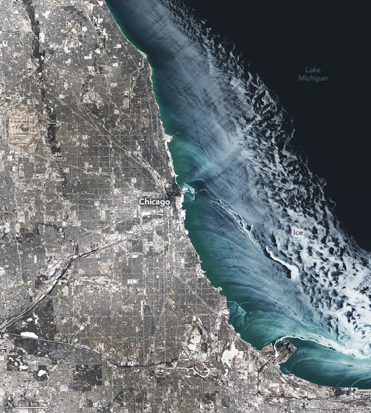
A Chill Over Chicagoland
Between January 19 and 24, 2025, a brutal cold snap hit Chicago. This satellite image captured a glimpse of the wintry aftermath.
The first half of the cold spell saw the chilliest weather, according to the National Weather Service (NWS). On January 21, the air temperature in Chicago reached as low as minus 15 degrees Fahrenheit (minus 26 degrees Celsius). At the time, little to no snow covered the ground in Chicago, which NWS noted is uncommon amid sub-zero temperatures.
Snowflakes returned toward the end of the cold spell. Between the mornings of January 22 and 23, several waves of snowfall produced the blanket of white across the Chicago area visible in this image, acquired on January 24, 2025, with the OLI (Operational Land Imager) on Landsat 8.
Another expanse of white is visible atop Lake Michigan. This is lake ice, which grows on the Great Lakes each winter, though its extent and timing can be highly variable. Ice coverage on the Great Lakes typically reaches its annual peak in late February or early March.
On January 24, winds were blowing offshore and pushing ice away from the coastline, according to Jia Wang, an ice climatologist at NOAA’s Great Lakes Environmental Research Laboratory (GLERL). Areas of thin (dark) ice closer to shore transition into patchy areas of bright white ice away from shore. Wang thinks these whiter areas might be due to ice that has piled up and formed a very rough surface.
The area of Lake Michigan covered with ice in late January 2025 hovered around the historical average (1973-2024) for the time of year, according to data from GLERL. When the image was acquired, ice covered about 20 percent of the lake.
Meanwhile, several hundred miles to the east, ice on Lake Erie spiked well above average in late January, according to GLERL, with ice spanning around 80 percent of the lake. The ice was thick enough to temporarily immobilize a Canadian cargo freighter, according to news reports.
Scientists are currently investigating ways to use altimetry data from NASA’s ICESat-2 (Ice, Cloud and land Elevation Satellite-2) to determine the thickness of ice on the Great Lakes. According to Eric Anderson, a researcher at the Colorado School of Mines, such measurements could improve ice and weather forecasting as well as help us understand changes in Earth’s surface freshwater.
NASA Earth Observatory image by Michala Garrison, using Landsat data from the U.S. Geological Survey. Story by Kathryn Hansen.
5 notes
·
View notes
Note
.Today was our launch day! I am not sure if I have already sent in an ask about this or not, but today marks quite some time since my original launch alongside my counterpart! Happy birthday, CHIPSat. May this ask startle you as I hope it does. (/silly)
- ICESat-1. This is being sent in fairly last minute, so no worries whatsoever if it can't be posted on time.
2
4 notes
·
View notes
Text
Around the world, communities are bracing for sea level rise: the Netherlands is stabilizing its dikes, Senegal is relocating neighborhoods, and Indonesia is moving its entire capital city. These projects are hefty, expensive, and slow.
But they may need to pick up the pace. As new research shows, in many places, sea level rise will cause coastal flooding and other disruptions much sooner than anyone realized. It’s not that the water is rising faster; it’s that the land was lower to begin with.
Calculating when a rising sea will flood any one place involves a lot of math: you need to know the height of the water, the range of the tide, the elevation and slope of the land, the pace of sea level rise, and how much the land itself is rising or falling, among myriad other factors. As with all of science, the accuracy of these predictions is only as good as the data flowing into them.
The problem, according to the new study by Ronald Vernimmen and Aljosja Hooijer, two data analysts working on flood risk in Southeast Asia, is that time after time, the measurements of coastal elevation that scientists feed into their models have been wildly inaccurate. In tropical forests, says Vernimmen, these misinterpretations can be off by 20 meters or more. “Obviously, you can’t use that,” he says.
The problem stems from limitations in the technology typically used to measure elevation: radar. Radar blankets an area in radio waves, then measures how long it takes the waves to bounce back. But radar isn’t precise enough to separate treetops from terra firma, and a patch of pines or cluster of condos can easily exaggerate the elevation. Many studies of sea level rise still use radar elevation data collected by the space shuttle in 2000.
Lidar is a lot like radar, but it uses lasers instead of radio waves. A lidar detector like the one on the ICESat-2 satellite, which NASA launched in 2018, can send up to one million pulses each second, firing lasers that can pinpoint the gaps between buildings and trees to more accurately gauge the elevation of the land underneath. Analysts still need algorithms to filter that barrage of information into a functional map, but the results are far more precise.
Vernimmen and Hooijer spent the past few years filtering the new satellite data for Earth’s immense coastline, comparing elevation estimates gathered from radar with the newer lidar-based measurements. It wasn’t pretty.
The scientists’ big finding is that forests and buildings along the coast have skewed radar maps, presenting planners with inaccurate elevation data. Lidar showed coastlines often lower than first realized. This has two important implications: the same amount of sea level rise will be able to reach much farther inland, and it’s going to happen a lot sooner than expected.
The scientists’ new lidar-based estimate predicts that roughly 482,000 square kilometers of land will be submerged with one meter of sea level rise, nearly triple the 123,000 square kilometers predicted by radar-based projections. That’s an extra Cameroon-sized chunk of Earth, currently home to roughly 132 million people, that will be underwater by 2100 under a high-emissions scenario.
1 note
·
View note
Quote
The beams were synchronized with a tiny green dot that was briefly visible between the clouds. He guessed it was a satellite, so he investigated orbital data and got a match. NASA’s Ice, Cloud and Land Elevation Satellite 2, or ICESat-2, had flown overhead that night. Fujii posted his findings on social media, which eventually got the attention of the NASA team.
Mysterious Green Lasers Near Mount Fuji, Japan Have a “Chilling” Explanation
1 note
·
View note
Video
youtube
ICESat-2 Adds the Third Dimension to Earth.
ICESat-2 will provide scientists with height measurements that create a global portrait of Earth's third dimension, gathering data that can precisely track changes of terrain including glaciers, sea ice, forests and more. The single instrument on ICESat-2 is ATLAS, the Advanced Topographic Laser Altimeter System, will measure melting ice sheets and investigate how this effects sea level rise, investigate changes in the mass of ice sheets and glaciers, estimate and study sea ice thickness, and measure the height of vegetation in forests and other ecosystems worldwide. "Eternal Circle," Laurent Dury, Koka Media SACEM Complete transcript available.
NASA Goddard
0 notes