#halfmarathonhistories
Explore tagged Tumblr posts
Text
There and back again: Miles 12 - 13.1
Miles 12-13.1 Great Victoria Street - Bruce Street - Dublin Road - Botanic Avenue - University Street - Ormeau Road - Ormeau Embankment.
Well we’re almost there, just over 2 miles to go and we find ourselves on Great Victoria Street. This is one of the more famous streets in Belfast, home to a great deal of places of interest. The first building of note you will see is the Presbyterian Assembly Building, whose spire you saw as you ran down Grosvenor Road. Built between 1900 and 1905 by Young and Mackenzie, it is the main meeting point for Presbyterians in Northern Ireland. Its 40ft high clock tower houses the first turret clock in the British Isles to be powered by electricity. It is also home to a series of stained glass windows by renowned stained glass artist, Wilhelmina Geddes.

Across the road from the Assembly Building is the Friend’s Provident Building which was also built by Young and Mackenzie in 1901. It is distinguishable by the large crest of Belfast at the top of the building. Belfast born, landscape artist, Frank McKelvey kept a studio here from 1944-1966.
To your right you will see the Grand Opera House. One of the finest buildings in the city. Originally built in 1894, it has gone through extensive restorations throughout the past 125 years and has suffered numerous abuses from abandonment to bombings. When statutory listing came into effect in 1972, it was the first building to be listed. Classic FM also named it as one of the 10 most haunted concert halls in the world, with workers, actors and crew members all reporting supernatural goings on. Just in case you need some motivation to pick up the pace around this point.

As you come past the Europa, the most bombed hotel in Europe, you will see a sculpture of two women conversing. This is the monument to the Unknown Women Worker. Originally the piece was commissioned as a tribute to the red-light district of nearby Amelia Street. However, the artist, Louise Walsh found the original commission offensive and instead put forward her own proposal; two statues of women representing the low paid jobs taken by women and unpaid housework. One of the women is adorned with baby pacifier earrings and a baby’s bottle broach, while the other wears a typewriter as an apron and a phone attached to her chest.

As you run past the BBC’s Blackstaff house, you will then come to the corner of Bruce Street. As you turn down this street, you will see a large red brick building to your left. This is the Donaldson and Lytle building, a former warehouse built in 1901. If you have a keen eye and look up to the top of the glass part of the building, you will see a blue sign with the phrase ‘Truth Well Told’ etched into it. This is the slogan of American advertising firm McCann-Erikson. In 1921, this emblem was the first service company emblem to receive intellectual property protection through the U.S. Copyright Office. The McCann-Erikson Belfast office was taken over by the Belfast advertising firm, Lyle Bailie in 2004. Lyle Bailie were the group behind the shocking DOE and Peace Process adverts that still haunt your nightmares.

At the bottom of Bruce Street you then turn right onto the Dublin Road. As you pass the cinema and look to your left, you will be able to see the Somerset and Co. building on Hardcastle Street, this was the first reinforced concrete building in Ireland constructed using the Hennebique system, which is now standard in concrete construction.
Although there are a few bars on Dublin Road, one of note is The Elbow Room (now known as Liquor XXX part of Filthy McNasty’s). It is in this bar where our friend, Sam Thompson first gave his play ‘Over the Bridge’ to James Ellis of the Group Theatre. The Group’s refusal to produce the play caused a new theatre group to be formed by Ellis so the play could be performed. It is largely due to this meeting in The Elbow Room that we were able to cross Sam Thompson Bridge out of Victoria Park.
We soon leave Dublin Road, via Shaftsbury Square and onto Botanic Avenue. The first point of interest will be on your right. This is the Kinghan Mission for the Deaf. Built in 1877 and established as the Mission for the Deaf in 1899, it is named for the Reverend John Kinghan. An advocate of the deaf, dumb and blind he initially set up the institute in 1857 and moved to the Botanic Avenue site in 1899.
Further up Botanic Avenue is the Empire Music Hall. It opened as a bar in the 1980s, taking its name from the Empire Theatre of Varieties in Victoria Square (Where ‘Over the Bridge’ was first performed). It is the only pub in Belfast to be housed in a former church. The building itself dates back to the 1870s when it was a Presbyterian Church. The Church did not have an adjoining cemetery and as such, bodies were supposedly buried in a crypt beneath the building. Consequently, the Empire is as haunted as the Grand Opera House, with the ghosts of Victorian Presbyterians roaming the bar. Staff have reported supernatural occurrences since the Empire opened its doors, even causing some staff to quit out of fear. Again, something to think about as your legs start to get tired.

At the top of Botanic Avenue is Duke’s Hotel, which will be your cue to turn left onto University Street. This is a somewhat derelict street, dotted with student accommodation, hostels and abandoned office buildings.
Near the bottom of University Street is All Saint’s Church. Although the current building was completed in 1906, it has been operating as a church since 1887. Originally this was a large iron building, erected to house the overflow of the congregation from St. Mary Magdalene Church in Donegall Pass. This became known as The Iron Church and was the largest iron structure of its kind in Ireland at the time. All Saint’s became a parish in its own right in 1890.
The last building of note on University Street, is the unassuming former paint house on your left. This is now The Menagerie bar, a dive bar that has become a cultural hub for art and music in the city.
We now arrive at Ormeau road and the finish line is less than a mile away.
Immediately in front of you, before you turn onto the Ormeau Road, is Lavina Square, which until 1999 was the Ormeau Cricket Ground, the home stadium of the North of Ireland Cricket and Football Club. It had existed since 1867 but was demolished after a series of sectarian arson attacks. The club was the home of a mostly Protestant membership and this part of the Ormeau, as you will notice is largely Nationalist. Lavina Square is now a housing development partly owned by the housing executive.
Like the Falls, this part of the Ormeau Road played a pivotal role in The Troubles, with numerous bombs, riots and tragedies scarring the area. You will notice the murals and memorials of the victims of the conflict as you make your way towards the Ormeau Bridge.

Just before the bridge is the former site of the Asian Supermarket, whose new building you ran past during the first mile. The building is the former Apollo Theatre, an independent cinema that first opened its doors on October 30th 1933.
On your left as you arrive on the bridge is a sculpture of river bank animals called ‘The Black Bird of Belfast Lough’ named for the Seamus Heaney poem of the same name.

As we cross the bridge, we now turn left again onto the Ormeau Embankment, for the third and final time before we reach the finish line and take stock of the fact that we just ran the length of Belfast history.
Thanks to everyone who has joined me on this historical journey on the route of the half marathon.

For those interested my sources were:
Wikipedia Google ‘Secret Belfast’, Lorenxs Bacino and Kathy Curran, 2018 ‘Central Belfast – A Historical Gazetteer’, Marcus Patton, 1993 ‘Buildings of Belfast – 1700 – 1914’, C.E.B Brett, 1985 ‘Historic Pubs of Belfast’, Gary Law, 2002 Belfast City Council Website Discover NI Website
If you found any of this interesting, I recommend doing some of your own research and reading on Belfast and the surrounding areas, there are literally hundreds of things I left out, from the well-known to the obscure. If you ever see something and wonder ‘what’s the craic with that?’ then just give it a Google and see how far the rabbit hole goes.
Thanks again and good look tomorrow if you’re running, and please consider giving a donation to Alliance for Choice via my fundraiser here, and of course continue to donate to whichever charities inspire you throughout your life.
See you at the finish line.
Jonny
0 notes
Text
Go West: Miles 10-11
The 10th mile is the most diverse stretch of this race. Taking you from Arthur Street to the Falls Road. Arthur Street is one of the more picturesque streets in Belfast city centre, with impressive buildings spanning the 18th – 21st Century on either side of the street.

Both Arthur Street and Chichester Street are named for one of the founders of Belfast, Arthur Chichester. Who reportedly imprisoned Conn O’Neil for treason in the 1600′s.

Chichester Street is another impressive street of the city. Ornate buildings in Edwardian, Victorian and Georgian styles surround you on either side. If you look right towards Donegall Place, you will see several sculptures of ships sails commemorating the famous liners built by Harland and Wolff. Further down Donegall Place is one of the oldest buildings in Belfast, a former terrace house built in 1790 it is now home to the clothing store, Oasis.

To your left will be Belfast City Hall, one of the most impressive buildings in the city. It contains a great deal of monuments including memorials for the Titanic disaster of 1912 and the Irish soldiers who died during the Korean war of 1950 – 53.
The Scottish Provident Building will be coming up on your left, if you look closely you will see the four panels on the front of the building representing Belfast’s industries of shipbuilding, printing, rope making and spinning. You will also run past the Linen Hall Library, this is the oldest library in Belfast and has existed in some form since 1788.

You will now be running past some of the less attractive buildings in the city before turning onto Queen Street. This street used to be the most exciting street to walk down, as it was home to Leisure World. A magical toy shop that was always a highlight of a childhood visit to Belfast. It closed in 1998 and Queen Street is now home to more student accommodation and car parking.
You will also notice the former Hospital for Sick Children, built in 1877. It became a RUC station after the hospital moved to the Falls Road, but has been derelict since the 1990s.

At the bottom of Queen Street you will see Chapel Lane. This is home to St. Mary’s Chapel, the first Catholic Church built in Belfast. Local Presbyterian and Church of Ireland communities paid to build the church for their Catholic neighbours as they had nowhere to celebrate mass in the city, with Catholics previously having to meet in Friars Bush on the outskirts of Belfast. The first mass was celebrated in St Mary’s on Sunday 30th May 1784. You will now turn left onto Castle Street, formerly Hercules Street named for leading Belfast citizen, Sir Hercules Langford. You will see the Hercules Bar as one of the few reminders of this street’s original name.
Castle Street will be your first indication that you are entering the more Nationalist area of Belfast, with signs in the Irish language and Divis tower in the distance.
As you run past the Morning Star House, you will find yourself on Divis Street and you’re on your way into West Belfast. This part of the run allows you to see a lot of the deprivation that still blights this city. The Welcome Organisation and Morning Star House are in close proximity to each other and provide aide to homeless people and people struggling with addiction.
Behind the Welcome Organisation you will see the Belfast Peace Wall, which separates the Loyalist and Nationalist communities of West Belfast and is the longest wall of it’s kind in Northern Ireland.
As with the Newtownards and Albertbridge Roads, this part of Belfast wears its national identity on its sleeve. You will see the Radió Fáilte building on your left, this is an Irish language radio station available across the world. You will also notice a lot of murals detailing the tragedies of The Troubles as well as the violent history that has shaped this part of the city. You will also see murals depicting solidarity with other countries around the world going through their own struggles for identity, such as Palestine and Catalonia.

Divis Street then becomes the Falls Road, a very famous road in Belfast city and the site of many defining moments of The Troubles. It is also home to one of the three Carnegie Libraries that were built in Belfast. This was built in 1908 and is the only one of the three that is still used as a Library.
You finish your 10th mile around Dunville Park. This was the first park presented to the city as a gift. It was presented to the city of Belfast by local whiskey distiller, Robert G Dunville in 1889 and opened to the public in 1891.
This park and the Royal Victoria Hospital will be your cue to turn left and head for your 11th mile down the Grosvenor Road. This is a largely residential road and, thankfully, is mostly downhill. This isn’t the most exciting stretch of road, you will get a good view of the Dunville Park Fountain to your left and in the distance you will see the Seahorse symbol of the new Grand Hotel on Bedford Street and the green copper spire of the Presbyterian Building on Great Victoria Street.

As you come to the end of the Grosvenor Road, to your right you will see the Boyne Bridge. Although built in 1932, it incorporates two arches from the original bridge of the 1600s. This is where King William of Orange crossed on his way to the Battle of the Boyne and is the same bridge which King James retreated across after the battle. This bridge is unfortunately due for demolition, so try and get a glimpse while you can.
As you complete your 11th mile you will find yourself on Great Victoria Street and the finish line is but 2 miles away.

Come back next time for the last stretch of the race, and don’t forget to donate to Alliance for Choice via my fundraiser.
Jonny
0 notes
Text
Out of the East: Miles 7 - 9
Victoria Park - Airport Road - Sydenham Road - Queen’s Quay - Queen’s Bridge - Donegal Quay - Queen’s Square - High Street - Cornmarket
The seventh mile brings you into the grounds of Victoria Park. First opened in 1906 and landscaped by Charles McKimm, who also built the Tropical Ravine in Botanic Gardens, Victoria Park is home to a large variety of wildlife. Try and spot the swans, geese, ducks, herons and other water birds that populate the park. The route takes you around Conn’s Water, part of the Connswater River named for the last King of Castlereagh, Conn O’Neil who ruled as a Gaelic lord from 1601 – 1619. You can see his influence throughout East Belfast especially with Connswater Bridge and Connswater Shopping Centre. You can also see his inauguration chair in the Ulster Museum if you are looking for something to do after the race.

This route also takes you past the poetry trail of Victoria Park; ten nature-themed poems written by local primary school pupils and etched onto metal plaques, though you likely won’t want to stop and read them at this stage of the race.
As you finish your 7th mile you come to the Sam Thompson Bridge, named for Northern Irish playwright, Sam Thompson. Specifically it was named for his controversial 1957 play, ‘Over the Bridge’ a story of a sectarian dispute in the Belfast shipyard. It was not performed until 1960, with the Ulster Group Theatre refusing to produce the play stating ‘It is the policy of the directors of the Ulster Group Theatre to keep political and religious controversies off our stage’. Fortunately the play became a huge success and allowed sectarianism in Northern Ireland to be displayed for the world to see. Across the bridge you will see The Short Brother’s building. The Short’s Brother’s first established as a company in London in 1908 and was the first company in the world to build production aeroplanes. They have had a presence in Belfast since 1936 and have concentrated all their production here since 1947.

The Airport Road and Sydenham Road is now your path to the industrial revolution that shaped Belfast for most of the 20th century. You will see the entrance to Harland and Wolff shipyard as well as a close view of the famous Samson and Goliath cranes. You will also be able to see the Public Record Office of Northern Ireland (PRONI) and just beyond this building is Belfast Metropolitan College, which is on the newly named Bell’s Theorem Crescent, named for famed Northern Irish physicist, John Stewart Bell.
As you continue past the SSE Arena and Odyssey Pavilion and onward along Queen’s Quay, you will see some notable buildings across the river Lagan: The Harbour Commissioner’s Office building, the AC Marriot Hotel, the Royal Mail building, The Custom House building and the tallest building in Ireland, The Obel Tower. This skyline provides a living history of Belfast’s architectural development, from 1848 – 2018.
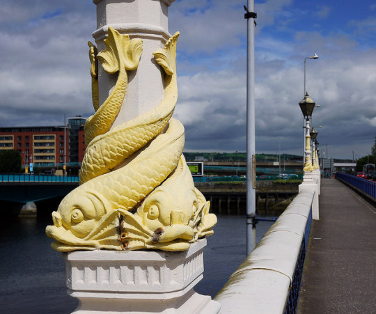
We finish this stretch of the race and say goodbye to East Belfast by crossing the Queen’s bridge. This bridge was opened in 1849 by its namesake Queen Victoria. A very ornate bridge designed by prominent architect Charles Lanyon, whose fingerprints are all over this city. The lampposts on this bridge are one of my favourite architectural pieces in Belfast. If you haven’t seen them up close before, I recommend you take this opportunity to appreciate their detail.
Welcoming you to the city centre is the Beacon of Hope sculpture. Designed by artist, Andy Scott and completed in 2006 it represents the Angel of Thanksgiving, The globe at her feet indicates the universal philosophy of peace, harmony and thanksgiving, and has marked on its surface the cities where the people and industries of Belfast migrated and exported to. One thing to be thankful for is that there are just over 4 miles left to go.
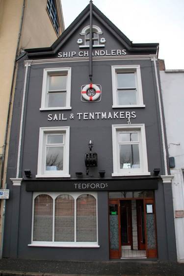
As you run along Donegal Quay, you will again be surrounded by Belfast’s maritime history. Tedford’s ‘Ship Chandlers, Sail & Tentmakers’ and the adjacent warehouse where canvas sails were sewn will be on your left. in the 1850′s Tedford’s ships would be able to pull up right beside the shop to collect their supplies, arriving from as far as South America and the Caribbean, almost as far away as Ormeau Park will feel.
Passing the famous ‘Big Fish’ or Salmon of Knowledge, you will then turn down Queen’s Square. This is a rather famous part of the city, but there are still a few elements that get overlooked, such as The Calder Fountain, erected in 1859 to honour animal rights activist and founder of the USPCA, Francis Calder. Calder was a veteran of the Napoleonic wars and set up the Belfast Society for the Prevention of Cruelty to Animals to better improve the existence of animals across Ireland. Notably he installed water troughs for horses and cattle that worked in the city, making a fountain a fitting tribute.

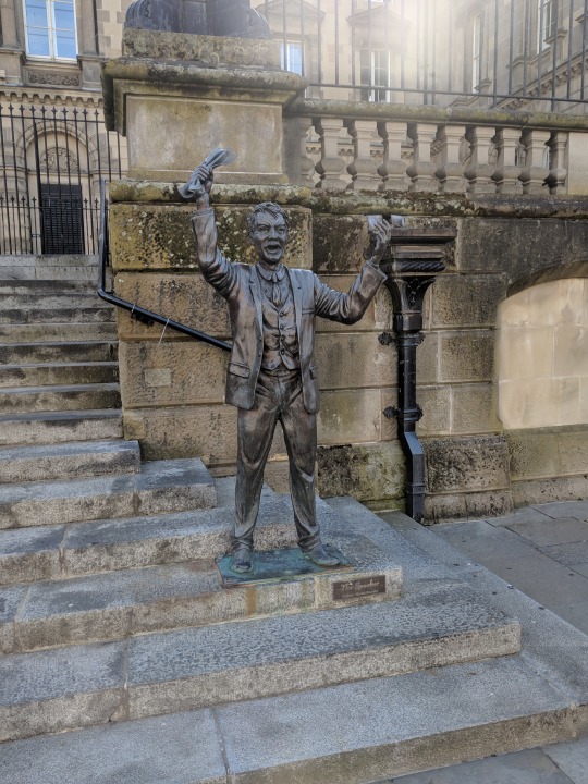
If you look into Custom House Square you will see Speaker’s Corner, with ‘The Speaker’ sculpture, commemorating the great orators who spoke on the steps of Custom House, such as Jim Larkin who would attract crowds of thousands to his speeches for the Dock Labourers Union.
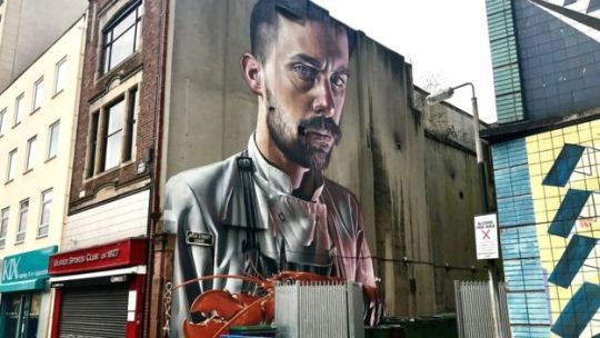
As you run past the slanted Albert Clock and onto High Street, you will see a large mural of a chef by Australian street artist Sam Bates, AKA Smug. On the other side of the road is St. George’s church, built in the early 1800s on one of the oldest religious sites in Belfast it is a beautiful church and even is the home to a throne of King William of Orange.
After High Street you finish your 9th mile in Cornmarket, formerly the Shambles, it was the centre for a great deal of market activity for Belfast in the late 1600s and early 1700s. It is also the site where Irish Revolutionary Henry Joy McCraken was hanged for treason. You will also see the Arthur Square Masonic Hall. Completed in 1869 it was one of the last buildings designed by Charles Lanyon, himself an influential figure in Freemasonry. The fact that this is the end of the 9th mile and the number 9 is sacred in Freemasonry is, presumably, a coincidence and not something to concern yourselves with.
Come back next time as we head through the city centre and on westward.
Thanks again to everyone has read this so far and has donated to my fundraiser.
Jonny
0 notes
Text
Almost Halfway There: Miles 4-6.
Miles 4 - 6
Albertbridge Road - Newtownards Road - Dee Street - Sydenham Bypass.
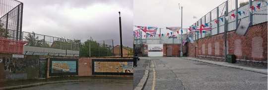
The next few miles takes us into the heart of East Belfast. As you turn on to Albertbridge Road you will notice a large ‘Peace Wall’ to your left. This separates the Catholic Short Strand from the Protestant Cluan Place. A remnant from the Troubles that continues to enforce the differences between the two communities, just in case you ever wonder why there’s still tension in this city, when you grow up with a literal wall between you and your neighbours you tend to harbour a sense of mistrust.
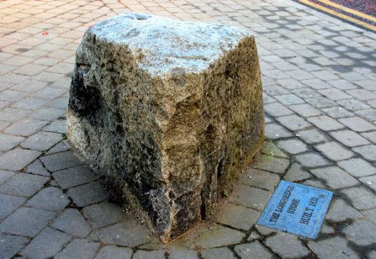
Further along the road, you may notice a large stone outside the XOXO Tanning Club. This is the Long Bridge Stone. The Long Bridge crossed the Lagan between 1688 and 1841. It was demolished and replaced in 1841 by noted Belfast architect, Francis Ritchie. While Ritchie was demolishing the bridge, a friend of his, a Doctor who lived on the junction between Castlereagh Street and Albertbridge Road requested a stone from the bridge as a souvenir. Ritchie obliged and placed the stone in the Doctor’s garden. As the years went by, the Doctor’s home was replaced with a bar known as McShannon’s but the stone remained. Local folklore claimed that the Long Bridge Stone was actually the mounting stone used by King William of Orange to mount his horse on his way to the battle of the Boyne, however King William was in Ireland 150 years before the stone was placed there and certainly never made it to the Albertbridge road. The Long Bridge was replaced by the Queen’s bridge, which you will cross around the 9th mile.
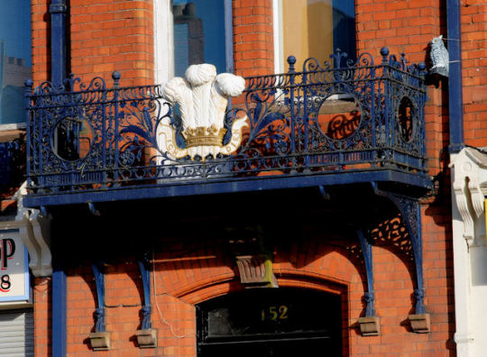
There are a few interesting architectural points along the Albertbridge road. There is the old Musgraves Factory, now The King building, a multipurpose office and retail building, you will notice the balcony above the main door featuring the heraldic badge of the Prince of Wales, ‘The Prince of Wales’s Feathers’. If you look closely, you may also see a small statue of an owl attached to the balcony. This is a nod to the scout troop ‘Owl Patrol’ which used to meet in the YMCA Mountpottinger building which is a bit further up on the right. Opposite the YMCA building is the Ballymacarrett Orange Hall, completed in 1901. All 3 are quite beautiful buildings, but unfortunately are in a bit of disrepair.
Just before you get to the YMCA building, you will notice a small park on the left hand side of the road. This is the Bridge Community Garden which is home to the Soundscape Park Project. Here, loudspeakers are hidden around the garden and play sounds from all over the world, from the crashing of waves, the sounds of the Amazon Rainforest to the factory sounds of Harland and Wolff.
As you approach your 6th mile you turn onto the Newtownards Road, in case the Albertbridge Road left you in some kind of doubt, the Newtownards Road should confirm your suspicions that, yes, this is a Protestant, Loyalist part of the city. You will notice shops selling instruments and paraphernalia for Orange marches and Loyalist band parades, as well as flags supporting the various provinces of the United Kingdom and British Army.

A prominent building on the Newtownards Road is the Portview Trade Centre. Originally the Jaffe Spinning Mill named for its founder, prominent Belfast citizen, Otto Jaffe it was sold to Mackie’s in 1912 and became the Strand Spinning Mill. Here, flax tow, munitions and viscose rayon were produced until 1983 when the mill closed. It is now home to numerous businesses including Boundary Brewing, a co-op owned local brewery who host monthly tap rooms and supply beer to various bars around the city and the rest of the world.

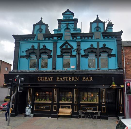
An indication to turn right onto Dee Street is the Great Eastern Bar. An absolutely stunning building built in 1890. Named after the Isambard Kingdom Brunel’s iron steamship, The Great Eastern. A ship that was built in London in 1858. It has changed name a few times over the years including the Red Hand Bar and the Ulster Arms, but was changed back to the original Great Eastern Bar in the 1970s.
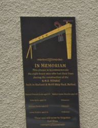
Dee Street is home to the Harland and Wolff Welder’s club, you will see a small plaque on the wall outside commemorating 8 men who lost their lives constructing the Titanic. This street will also be your first clear look at the Harland and Wolff cranes, Samson and Goliath.
As you cross over the Dee Street Bridge, the cranes come into view and you turn a corner onto Sydenham bypass. The Sydenham bypass was the first dual carriageway in Northern Ireland with work beginning in 1938 and fully opening in 1959.
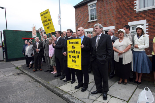
This isn’t the most interesting stretch to run down, but there are one or 2 spots of interest. You will be able to see The Oval stadium which has been the home ground of Glentoran FC since 1892 and has been the site of numerous protests through the years, including a protest in 2008 by the Free Presbyterian Church of Ulster against the IFA’s decision to hold games on a Sunday. Hopefully they don’t find out which day the half marathon is on this year.
Come back next time for a little about the next stretch of the race. You’re almost halfway home.

Thanks again to everyone who has been reading these posts and donating to my fundraiser.
There’s still time to donate here.
Jonny
0 notes
Text
Retreading Old Ground: Miles 2 & 3
Welcome back. I have been continuing my training these past few days. Ran to East Belfast so I could see the Refill Quarter, a new package free store on the Belmont Road. Great to see things like this in Belfast and they will be stocking my dear friend, Rebecca’s innovative ‘Power Pauses’ wellbeing cards, you can find out more about the work she is doing with her self-care project, ‘Happy is’ here. I also ran past the 343 who do some great work with my chosen charity Alliance4Choice, which you can donate to via my fundraiser here.

As the next few miles of the Belfast half Marathon go over some of the ground as Mile 1, I will be talking about mile 2 and mile 3 together in this post.
Mile 2 – Ravenhill Road – Ormeau Park
As you turn left from Park Road you begin your second mile along the Ravenhill Road. Originally the Ballynafeigh Road, it was, until 1815, the Ballynafeigh area’s only road into Belfast centre. The Ormeau Golf Club can be seen on your left. Formed in 1893 this is one of the oldest golf clubs in Ireland and is the closest golf club to Belfast City centre. During the 1st and 2nd World Wars, the land of the golf course was used to herd and graze flocks of sheep before they were sent to slaughter or to the docks to be sent to England to aide in the war effort, much to the ire of the golfers. Further down the Ravenhill, you will see the Martyr’s Memorial Church, completed in 1969, this is where Ian Paisley preached his firebrand form of Evangelical Christianity for over 50 years. There is a clock on the top of the church with the message ‘Time is Short’, a message you will question when running for 5 minutes feels like 20.

The final church before we turn into the park, will be the Ravenhill Presbyterian Church which was completed in 1898. The ‘Tornado of the pulpit’ W.P Nicholson preached here in 1923 to a special ‘men-only’ congregation of Harland and Wolff shipyard workers. Led by a Salvation Army band, they marched from the shipyard straight to the church, and as Reverend John Ross recorded; "when the gates were opened, the crowd was so large that the men got wedged between the pillars and so fierce was the struggle to get in that the central pillar was moved from its place." As a result of Nicholson’s preaching, a shed was erected in the shipyard by Harland and Wolff known as ‘the Nicholson shed’ for newly converted shipyard workers to return stolen tools. Their new found faith giving them a new found sense of guilt.
We now turn into Ormeau Park, the oldest municipal park in the city and home to a few historic curios. Ormeau Park was originally part of the estate of the Donegall family, who moved to Ormeau Cottage in 1807. The Second Marquis of Donegall extended the cottage in the 1820s and lived there until his death in 1844. Upon his death, his gambling debt had exceeded £400,000 and so the family was forced to sell much of the estate and their possessions. After being used as farmland and grazing sites, Belfast city purchased the land in 1869 and it was opened as a park in 1871. Ormeau Park has been the site for numerous historical events; on the 18th March 1972, William Craig made one of his infamous ‘Shoot to Kill’ speeches to over 60,000 supporters of the Ulster Vanguard where he stated "we must build up a dossier of the men and women who are a menace to this country because if and when the politicians fail us, it may be our job to liquidate the enemy". Only took until mile 2 to mention the Troubles, but for better or worse it’s as vital to the history of Belfast as the River Lagan. You will probably notice a lot of cyclists in the park today but during the 1800s cycling was banned, however an exception was made for the Northern Cycling Club, who would meet at the Superintendent's house and cycle their pennyfarthing bikes all the way to Portrush.

The superintendent’s house is still standing in the park, built in 1878 it was originally home to the park superintendent and his family. After many years of disrepair it was refurbished in 2008 by a collaboration between Hearth and the Housing Executive. It is insulated by sheep’s wool and uses an air-source heat pump while maintaining the original red brick exterior. A great example of maintaining and improving the city’s architectural heritage, a rare site as you will notice as the race continues.
Mile 3 - Ormeau Embankment (again) - Ravenhill Road
We will then leave the park and onto the Ormeau Road via the Marquis Gate and head back down the Embankment and onto the Ravenhill Road. Keep an eye out for the old Parkview Bar, a former coach inn that has laid derelict for quite some time. A lovely old pub that will hopefully get some life injected into it in the future. This part of the Ravenhill has less houses on the road itself and is home to businesses and corner shops from quite a diverse selection of countries, with Turkey, Poland and India all represented. As you reach the bottom of the Ravenhill you will see River’s Edge, a large red brick building that is home to Bryson LaganSports who offer a whole range of outdoor activities from zorbing to canoeing. The building is the former site of the Downshire Pottery or ‘Belfast China Manufactory’. A ceramics manufacturer which operated between 1787 and 1807. In 1993 an archaeological excavation discovered that Belfast ‘creamware’ had been manufactured there. Which I imagine is a fact only interesting to ceramic enthusiasts, or ‘pot-heads’ (pause for applause).

Come back next time to learn a little bit about Mile 4 and remember to throw a wee donation to Alliance for Choice via my fundraiser.
- Jonny
0 notes
Text
Introduction and the First Mile
Like most people, I have been running for most of my life in a metaphorical sense, but also, like some people, I have been running in a literal sense. Recently I grew tired of my regular 5 and 10k routes and decided to start running to different parts of Belfast. I would pick a landmark or a building I wanted to see and run to it. It started with an intention to run from my home in South Belfast to the East, West, North and South of Belfast. So I ran to Stormont and up that nightmare hill and home again, I ran to Belfast Castle and up that nightmare hill and home again, I ran to Black Mountain and up that nightmare hill and home again and I ran to Barnett Demesne which doesn’t have any nightmare hills, though I ran via Ridgeway Street, which is more an inconvenient hill. After the North/South/East/West runs, I started running to the landmarks, St Martin’s Church on Woodvale Road to see Shankill Graveyard and the ancient stone font in front of the church. The Great Light in the Titanic Quarter, Sailortown, both sides of The Peace Wall, The Giant’s Ring, the abandoned synagogue in Annesley Street, the James Connolly Museum and all 3 Carnegie buildings to name a few. And so as I built up my distance and strength and cured the boredom by taking in the interesting aspects of this city, I felt I was ready enough to do at least a half marathon, and as one of the things I enjoy about running is finding the interesting historical and unusual sites in this city, I have decided to write a little bit about the kind of things you will see on each mile of the Belfast half marathon.
I am also raising money for Alliance for Choice, you can donate here if you are so inclined.
Mile 1 – Ormeau Embankment – Park Road
The Ormeau Embankment, to be honest, is not the most exciting stretch of road to run down, or up. It is a long stretch of road, albeit, with a little bit of history attached to it. The name ‘Ormeau’ comes from the French surname ‘Ormeau’ meaning a person who lived near an elm tree, and it is elm trees you will see as you run along the embankment. The park used to stretch to the banks of the Lagan where the embankment is now, you can see in the picture below that there used to be a little beach there and you used to be able to cross the river by boat to get to the Gasworks.

Across the Lagan you will be able to see the long chimney of the Belfast Gasworks, once the heart of the industrial revolution in Belfast. Built in 1822, the Gasworks provided gas lighting to the entire city for 160 years. The profits generated from the Gasworks even went towards building City Hall. It is now the home to the Radisson Blu hotel and quite a few tech companies. A lot of the original architecture remains, including one of the largest examples of the crest of the City of Belfast.
The largest Asian Supermarket in Northern Ireland was recently built along the embankment. Here you can buy various groceries from across Asia and Europe, including Chinese and Japanese snack foods. There is also a pleasant café upstairs, where you can get breakfast once the race is over, or if you’re waiting for someone to finish you can grab a coffee while you wait and watch everyone set off.
We end the first mile in Park Road, this leafy street that connects the Ormeau to the Ravenhill is the home of the Rosetta Masonic Hall, a beautiful building completed in 1930. It is the current meeting place of the Provincial Grand Lodge of Down and their various Masonic Lodges. Where, I can only assume, they secretly control the world.


Come back next time to learn a little bit about Mile 2 and remember to throw a wee donation to Alliance For Choice.
- Jonny
0 notes