#guelb er richat
Explore tagged Tumblr posts
Text
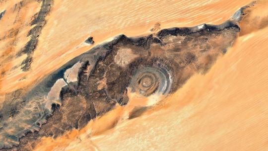
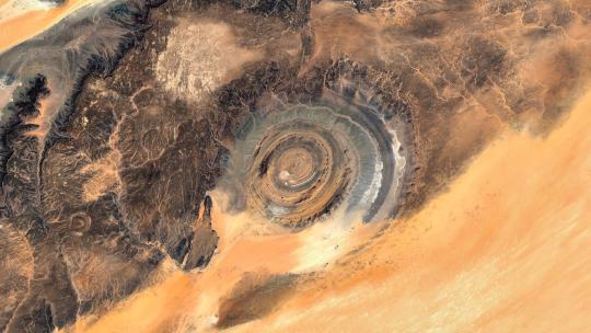
Richat Structure (Guelb er Richât) - Mauritania 🌍 4K link
#mauritania#richat#guelb er richat#structure#eye of the desert#google earth#wallpaper#aerial photography#satellite view#4k#abstract#atlas#texture#desert#relief#earth art#earth from above#earth from space#dji#landscape
37 notes
·
View notes
Text
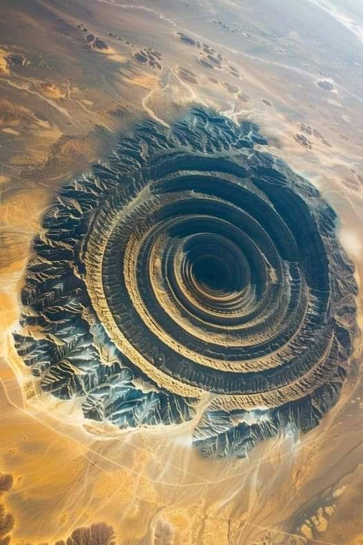
Richat Structure (Guelb er Richât) - MAURITANIA
144 notes
·
View notes
Text
[ THE LOST EMPIRE ISN'T HERE ]

THE RINGS OF MAURITANIA:
Know by the Locals as "Guelb er Richât," "the eye of Richat" the rings of Mauritania are a set of mountains in a circular formation likely formed by a meteor impact.
[ NOBODY CAN TELL ME THAT AFRICA DOSENT SUCK ]

" Unknown man - wat doen jy, wegbreek van hierdie plek af dit is vervloek deur demone jy sal sterf!!.. luister na my woorde gaan weg jou idioot!!.. bahh hel toe met jou dan gaan n dag af soos n dwaas!!
Vincent - 👀😮😯... 👍👍"
[ NEVER MIND I LOVE AFRICA ]

".. yeah, pretty much. I looked into the distance and saw this massive hole in the ground. At first, I thought It was cave, but no, it was this massive sink hole.
To my surprise, inside it was this man made hallway that probably used to go on for miles. The inside was so huge I actually decided to make camp and rest a bit. One side of the hallway was collapsed and the other just scared the shit out of me.. Honestly, i dont remember how i actually got myself to keep going and check deeper inside of it."
[ I NEED TO REST FOR A MINUTE... IM NOT ACTUALLY SCARED ]
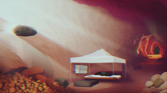
"98 : Do you think Vincent stuff got flooded with cement? Is it still down there?
99 : Hey, K!! is Vincent stuff still down in the cave!!
KL777: What??! No, we gave it back to him. Like a weak or two later."

[ FAILED AMBITIONS ]

"98: What is that place anyway..
99: Who knows.. Kalesh seemed to know something about it but he wouldn't say.
98: Maybe Atlantians built this?
99: No way, Atlantisans build better than this shit hole. Plus fuckers always have to build a pyramid.
98: Hmm.. true, but who knows, maybe this is part of their earlier works, huh? ever thought about that, you dumb bitch.
99: I will kick your Ass, don't make me get off this chair
99: Wait a minute. Wtf is that.. right there... do you see that shit wtf is that..
98: That's your mom."
[ A PLACE THAT SHOULDN'T EXIST ]

"98: Hey, that hole Vincent used to get into District 9. Do you think we can use it.. I mean, there's an entire city we could probably useright there. We could just hide right under their noses.
99: That's a stupid Idea 98, we'd get nuffed out in a minute if we set up a base there..
98: NO, no think about it right now we are absolutely fucked if they find us here we have no exit strategies if they find out where we are sooo.. it wouldn't hurt if we had a beta base, and things would be heck of a lot easier if we managed to sneak in a wire into District 9.
99: Again, that's a dumb idea 98. Plus, back when all of this happened, they sent Kalesh to plug up the hole. So he can tell you himself, that hole, and that entire City doesn't exist anymore."
[ THE ONLY DIRECTION YOU NEED TO GO, FOWARDS ] [THE MESSAGE ]

"KL777 - ارقد بسلام يا أخي، لترشدك إلى الآب العليم لتتحرر من قيود الميلاد الجديد."
Always and forever, we will fight to the end of time.
[ THE BLACK WALL ]

[ SECRET ]
[ BEGINNINGS IN THE DARK ]

Loading... No I refuse fuck you...
youtube
0 notes
Photo

The Richat Structure, also known as the Eye of the Sahara and Guelb er Richat, is a prominent circular feature in the Sahara near Ouadane, west–central Mauritania.
6 notes
·
View notes
Photo

NASA satellite image of the Richat Structure.
The Richat Structure, also known as the Eye of the Sahara and Guelb er Richat, is a 40-km diameter prominent, domed, deeply eroded, slightly elliptical, circular feature in the Sahara desert of west–central Mauritania near Ouadane. The sedimentary rock exposed in this dome range in age from Late Proterozoic within the center of the dome to Ordovician sandstone around its edges.
135 notes
·
View notes
Video
youtube
WHAT is the Richat Structure / The Eye of the Sahara / Guelb er Richat a...
0 notes
Photo


La structure de Richat (ou dôme de Richat), surnommée « l’œil de l'Afrique » ou traditionnellement Guelb er Richât, est une structure géologique de 50 km de diamètre située dans le Sahara, en Mauritanie, et qui ne peut s'observer pleinement que depuis l'espace. Longtemps énigmatique, on pense aujourd'hui que c'est un volcan effondré.
12 notes
·
View notes
Photo

Have questions about images of Earth from space? All of these images were created using data fro


Have questions about images of Earth from space? 🛰️ 🌎 All of these images were created using data from using Landsat data from the @USGS. They’re not just beautiful -- they also allow scientists to study water, fires, glaciers and more! But when satellites like Landsat capture these images, they don’t look like what we see now. Someone has to process them into something our eyes can interpret. Comment with your questions and NASA Landsat imaging specialist Lauren Dauphin will answer! Image 1: Yukon Delta in southwest Alaska. Sept. 22, 2002. Lakes, sloughs, and ponds are scattered throughout this scene of the Yukon Delta in southwest Alaska. One of the largest river deltas in the world, and protected as part of the Yukon Delta National Wildlife Refuge, the river's sinuous waterways seem like blood vessels branching out to enclose an organ. Image 2: Western Sahara Desert. April 25, 2021. This image is shown as a natural color composite using the red, green, and blue bands. Also known as the Eye of the Sahara or Guelb er Richat, the Eye is a symmetrical dome of eroded sedimentary and volcanic rock. Image 3: Elephant Island. Dec. 13, 2020. The image shows a rare, cloud-free view of the remote island. In the center, Endurance glacier collects most of the ice flowing in the southeast direction. Elephant Island is located about 250 kilometers (150 miles) northeast of the tip of the Antarctic Peninsula. Image 4: Kalahari Desert, Namibia. Aug, 14, 2000. Sand dunes are encroaching onto once-fertile lands in the north. Healthy vegetation appears red in this image; in the center, notice the lone red dot. This is a false-color composite image made using near infrared, red and green wavelengths. Image 5: Malaspina Glacier, Alaska. Aug. 31, 2000. The Malaspina lies west of Yakutat Bay and covers 1,500 square miles. This is a false-color composite image made using infrared, near infrared, and green wavelengths. The image has also been sharpened using the sensor's panchromatic band. Image credits: NASA/USGS
Note: All rights belong to their respective owners #livenews, #cablenews, #usnews, #businessnews, #worldnews, #news, #eveningnews, #nightlynews, #breakingnews, #nightlynewsnbc, #nbcnewsnow, #newsnbc, #nbcnewslive, #nbcnewstoday, #newstoday, #newsstation, #stockmarket, #nbcnewslivetoday, #newsnbclive, #nbcnewslivestream, #nbcnewsspecialreport, #newswithshepardsmith, #coroner, #nbclive, #nbc, #abc, #nbcspecialreport, #report, #Iamlatest #latesttrend #latestnews #latestissue #latestart #latestpicture #latestupdate #FoxNews #CNN #SkyNews #AlJazeera #BBC #MSNBC #Euronews #GeoNews #NDTVIndia
0 notes
Photo

The Richat Structure, also known as the Eye of the Sahara and Guelb er Richat, is a prominent circular feature in the Sahara near Ouadane, west–central Mauritania.
18 notes
·
View notes
Photo
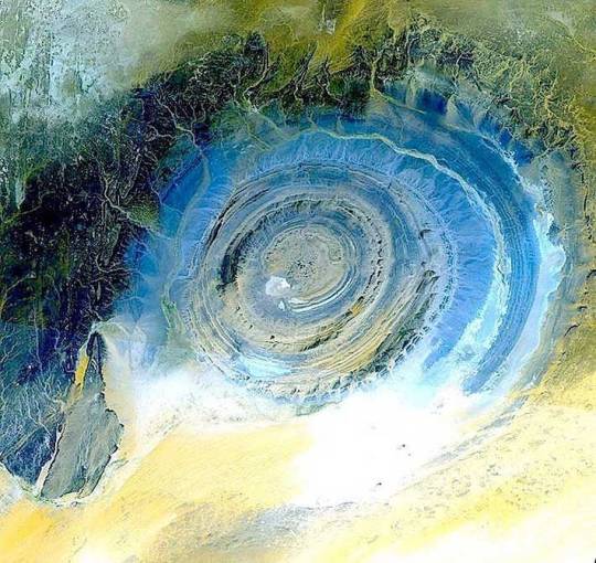
The Richat Structure, also called Guelb er Richât (Arabic قلب الريشات Qalb ar-Rīšāt), the Eye of Africa, or Eye of the Sahara is a prominent circular feature in the Sahara's Adrar Plateau, near Ouadane, west–central Mauritania, Northwest Africa. It is an eroded dome, 40 kilometres (25 mi) in diameter, exposing sedimentary rock in layers which appear as concentric rings. Igneous rock is exposed inside and there are spectacular rhyolites and gabbros which have undergone hydrothermal alteration and a central megabreccia. The structure is also the location of exceptional accumulations of Acheulean archeological artifacts. The Eye is one of the few breaks in the monotony, and now it's become a key landmark for them. Some people believe that the Eye of the Sahara is actually the remains of the city of Atlantis, which Plato described as concentric rings of water and land. #mauritania #africa #african #history #nature #facts #sahara #desert #information #knowledge https://www.instagram.com/p/CEELAJ7H90F/?igshid=184pcifwjjuhh
0 notes
Photo
It is also called The Richat Structure, also called Guelb er Richât (Arabic قلب الريشات Qalb ar-Rīšāt), or the Eye of Africa.
There are Acheulean archaeological sites are located along wadis that occupy outermost annular depression of this structure. Pre-Acheulean stone tools also have been found in the same areas. Artifacts are found, typically redeposited, deflated, or both, in Late Pleistocene to early Holocene gravelly mud, muddy gravel, clayey sand, and silty sand
The Eye itself is believed by geologists as a highly symmetrical and deeply eroded geologic dome.
A geologic dome is is a feature in structural geology consisting of symmetrical anticlines that intersect each other at their respective apices.
In the early days it was believed to be formed by an massive impact but repeated investigations throughout the years since the 1960's have concluded it is not due to lack of evidence.
A multianalytical study done in 2001 at the sign on the megabreccias came to the conclusion that carbonates within the silica-rich megabreccias were created by low-temperature hydrothermal waters. This study brought forth concerns that the structure requires international protection that also allows further investigation of its origin.
A breccias is a rock composed of broken fragments of minerals or rock that have cemented together over time by a fine-grained matrix.

The Richat Structure – “Eye of the Sahara” – “in northwestern Mauritania” photographed from space on 5 April 2019 from the International Space Station. Photo credit: National Aeronautics and Space Administration (NASA) [5568 x 3712]
64 notes
·
View notes
Photo

Le Guelb er Richât ou la Structure de Richat (surnommé l'Œil de l'Afrique), structure géologique (Image satellite) - Ouadane - Wilaya de l'Adrar - Mauritanie
0 notes
Photo

NASA satellite image of the Richat Structure.
The Richat Structure, also known as the Eye of the Sahara and Guelb er Richat, is a 40-km diameter prominent, domed, deeply eroded, slightly elliptical, circular feature in the Sahara desert of west–central Mauritania near Ouadane. The sedimentary rock exposed in this dome range in age from Late Proterozoic within the center of the dome to Ordovician sandstone around its edges.
12 notes
·
View notes
Photo
The Richat Structure, also known as the Eye of the Sahara and Guelb er Richat, is a prominent circular feature in the Sahara desert of west–central Mauritania near Ouadane. Photo by cosmonaut Fyodor Yurchikhin and the Russian Space Agency Press Services.
The structure is a deeply eroded, slightly elliptical, 40 km in diameter dome. Differential erosion of resistant layers of quartzite has created high-relief circular cuestas. Its center consists of a siliceous breccia covering an area that is at least 3 km in diameter.

#desert#nature#sahara#the richat structure#richat#mauritania#ouadane#fyodor yurchikhin#space#aerial#photography#sand#quartzite#cuestas#siliceous#siliceous breccia
106 notes
·
View notes
Text
10月
10.7(土) 大阪緑橋戦国大統領 open/start 18:30/19:00 charge ¥2,000(1d別) グル絶対/HASIYAN/KAZBANTANA/地下水道
10.8(日) 大阪谷町cafe&bar Lgt 神那/石川ヨナ/地下水道/Yosei(RED SNEAKERS)
10.18(水) 吉野町こびとさん open/start 19:00/19:15 charge ¥2,000(1d込) The Lime/てぶら/猫丸センチメンタルチャンネル/地下水道/雨本ふみ
10.27(金) 寿町音小屋 open/start 19:00/19:30 charge ¥1,800(1d込) CHATO/Guelb er Richat ensemble/Joke Vox/地下水道
0 notes
