#ground water surveyor
Explore tagged Tumblr posts
Visit Tumblr Blog
Explore Tumblr blogs with no restrictions, modern design and the best experience.
Last Seen Tumblr Blogs


Fun Fact
Total funding amounts to $125.3M.
Text
Ground Water Survey Services for Borewell and Tubewell In Bangalore
Bhoojal survey team provides groundwater survey services to locate potential borewell drilling points and open well locations. Groundwater survey can estimate depth of borewell for a good yield. Borewell survey aims at finding out aquifer zones , water bearing zones and weathered rocks with water permeability within a given area .
#groundwater#ground water survey#ground water surveyor#geophysical survey#hydrogeology#water survey groundwater exploration#underground water survey#geophysical engineering#soil resistivity test#resistivity survey resistivity meter#CGWA#ground water recharge#ground water exploration#groundwater monitoring#borewell drilling#ground water project
0 notes
Text
Satellite survey to locate underground water
What is Undergroundwater?
Underground water" typically refers to water that is located beneath the Earth's surface, in soil pore spaces and in the fractures of rock formations. This water can be found at various depths, from shallow groundwater near the surface to deep groundwater that requires drilling to access.
Groundwater occurs in underground fractured zones between rock surfaces and can be extracted by drilling vertical borewell in earth surface.

How satellite survey helps in finding groundwater?
There are many methods for ground water exploration used as of now -:
1) Hydrogeological surveys
2) Geophysical survey
3) Satellite survey to locate underground water
Satellite survey to locate undergroundwater is latest cutting edge technology utilized by experienced hydrogeologilst to locate underground water beneath earth surface

Satellite based survey to locate groundwater are conducted by taking high resolution images and mapping area to be surveyed and entering all required data for a particular site in high end geophysical softwares to determine aquifer zones and location of borewell point.
Satellite based survey to locate water is more effective compared to traditional methods
Survey conducted are cost effective and provides more reliable results .
We at bhoojal survey with experienced geologist have conducted many satellite based survey to locate underground water across the globe
For more details reach us out at https://bhoojalsurvey.in/
What We can expect from satellite survey for finding groundwater ?
A geophysical survey and hydro geological survey conducted can provide below details
1) Location of borewell point
2) Depth of Aquifers
3) Direction of undergroundwater flow
4) Depth, Dia, Type of borewell to be drilled
5) Hydrogeology of the area

Satellite technology is increasingly being used to locate and monitor groundwater resources around the world.
Combining data from different satellite sensors and ground-based measurements can provide a comprehensive view of groundwater resources, aiding in mapping aquifers and monitoring changes over time.
These satellite-based methods complement traditional ground-based techniques such as drilling and hydrological modeling, offering a broader and often more cost-effective approach to groundwater exploration and management.
For more details reach us out at https://bhoojalsurvey.in/
#hydrogeological survey groundwater#geophysicalsurvey#geophysical survey#groundwatersurveyor#how to detect underground water for borewell#borewell survey indore#ground water surveyors#cgwa noc#cgwa noc consultants#ground water exploration#ground water survey for borewell
0 notes
Text
The Kingdom of Mossland
KoM 2-9 | The Defense of the Realm
The armed forces of the Kingdom has been a long running and ever changing part of this build. A coastal fort was one of the first things I built in the city but it was very blah and I tore it down and put a scientific academy in it's place. But ever since then, I wanted some sort of structure that would act as the center of the Kingdom's defenses. Originally, this would have been a large fort guarding the harbor, but that area has been rezoned as part of the city. And then I realized I had never really expanded the Kingdom to the south and went looking around for some building inspiration, and I found the fort I had been looking for.

Fort Maillard
Built on an island guarding the southern entrance into the city, Fort Maillard is the home of the Kingdom's armed forces. Here, soldiers are armed and trained to defend the realm from the hordes of zombies and skeletons that plague the land. The fort also is the home of the Officer's School, where strategy and command is taught through extensive wargaming (this was an actual thing in history, not just something nerds do. There is also a Royal Surveyors team that has a bitter one-sided rivalry with the Explorer's Guild, who have replaced them as the realm's foremost cartographers. But the most important inhabitants of the fort, are the River Watch. These soldiers are responsible for guarding the Kingdom's many rivers, and have earned themselves a legendary reputation as the shields of the realm.


The River Watch
Responsible for the defense of the Kingdom's waterways, the River Watch have outposts and watch towers all over the Kingdom. Combined with their signature narrow boats, this network of watchers and boats allows the River Watch to quickly respond to threats all over the realm.
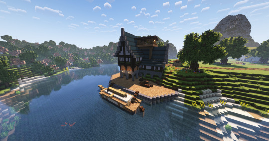


Their boats have collapsible masts to allow passage under low bridges, and a shallow draft, to avoid grounding out in shallow waters. The boats are equipped with sleeping areas, and a small kitchen, allowing the crews to stay on the river for extended periods of time. The inspiration for these boats are the narrow boats common to the canals of England. I reeeally wanted a cool name for the boats and the group, similar to how the Night's Watch in Game of Thrones are called Crows, but I really couldn't think of a river themed version. The Toads? The Swans? They all seem kinda lame.


The River Gates
The last thing I built was the river gates that guard the northern entrance into the realm's rivers. These gates are built into a cavern under the city and work together with the drawbridge to make unwanted passage into the Kingdom nearly impossible by river.


I know this was a long one, but larger builds to flesh out the project was my goal with the whole "Season 2" thing. I also have a job that mentally drains me, and my willingness and availability to sit and play Minecraft is not what it used to be. But I still like playing it. I recently joined a modded survival server with some people for the first time, but they all gave up by the end of the first week, which really sucked, so I came back to my kingdom. I have actually been debating calling a hiatus (or just an end entirely) on this and starting a new project. I feel like a new build style would be nice to explore, but at the end of the day, I am just one tired guy who has to accept he can't play as much Minecraft as he wants to.
*Fun fact, Fort Maillard gets it's name from the Maillard reaction, which is a chemical reaction that causes pretzels to develop that brown pretzely goodness when they are baked*
#minecraft#minecraft creative#minecraft build#minecraft aesthetic#mineblr#minecraft mizunos#mizunos 16 craft#minecraft cottagecore#minecraft worldbuilding#minecraft castle#minecraft screenshots#minecraft city#minecraft inspo#minecraft inspiration
25 notes
·
View notes
Text

Martian spring involves lots of cracking ice, which led to this 66-foot-wide (20-meter-wide) chunk of carbon dioxide frost captured in freefall by the HiRISE camera aboard NASA's Mars Reconnaissance Orbiter in 2015. Credit: NASA/JPL-Caltech/University of Arizona

As light shines through carbon dioxide ice on Mars, it heats up its bottom layers, which, rather than melting into a liquid, turn into gas. The buildup gas eventually results in explosive geysers that toss dark fans of debris on to the surface. Credit: NASA/JPL-Caltech/University of Arizona

Sometimes, after carbon dioxide geysers have erupted from ice-covered areas on Mars, they leave scour marks on the surface. When the ice is all gone by summer, these long scour marks look like the legs of giant spiders. Credit: NASA/JPL-Caltech/University of Arizona

As temperatures rise, powerful winds kick up that carve deep troughs into the ice cap of Mars' north pole. Some of these troughs are as long as California, and give the Martian north pole its trademark swirls. This image was captured by NASA's now-inactive Mars Global Surveyor. Credit: NASA/JPL-Caltech/MSSS

Surrounded by frost, these Martian dunes in Mars' northern hemisphere were captured from above by NASA's Mars Reconnaissance Orbiter using its HiRISE camera on Sept. 8, 2022. Credit: NASA/JPL-Caltech/University of Arizona
Avalanches, icy explosions and dunes: NASA is tracking New Year on Mars
Instead of a winter wonderland, the Red Planet's northern hemisphere goes through an active—even explosive—spring thaw. While New Year's Eve is around the corner here on Earth, Mars scientists are ahead of the game: The Red Planet completed a trip around the sun on Nov. 12, 2024, prompting a few researchers to raise a toast.
But the Martian year, which is 687 Earth days, ends in a very different way in the planet's northern hemisphere than it does in Earth's northern hemisphere: While winter's kicking in here, spring is starting there. That means temperatures are rising and ice is thinning, leading to frost avalanches crashing down cliffsides, carbon dioxide gas exploding from the ground, and powerful winds helping reshape the north pole.
"Springtime on Earth has lots of trickling as water ice gradually melts. But on Mars, everything happens with a bang," said Serina Diniega, who studies planetary surfaces at NASA's Jet Propulsion Laboratory in Southern California.
Mars' wispy atmosphere doesn't allow liquids to pool on the surface, like on Earth. Instead of melting, ice sublimates, turning directly into a gas. The sudden transition in spring means a lot of violent changes as both water ice and carbon dioxide ice—dry ice, which is much more plentiful on Mars than frozen water—weaken and break.
"You get lots of cracks and explosions instead of melting," Diniega said. "I imagine it gets really noisy."
Using the cameras and other sensors aboard NASA's Mars Reconnaissance Orbiter (MRO), which launched in 2005, scientists study all this activity to improve their understanding of the forces shaping the dynamic Martian surface. Here's some of what they track.
Frost avalanches
In 2015, MRO's High-Resolution Imaging Science Experiment (HiRISE) camera captured a 66-foot-wide (20-meter-wide) chunk of carbon dioxide frost in freefall. Chance observations like this are reminders of just how different Mars is from Earth, Diniega said, especially in springtime, when these surface changes are most noticeable.
"We're lucky we've had a spacecraft like MRO observing Mars for as long as it has," Diniega said. "Watching for almost 20 years has let us catch dramatic moments like these avalanches."
Gas geysers
Diniega has relied on HiRISE to study another quirk of Martian springtime: gas geysers that blast out of the surface, throwing out dark fans of sand and dust. These explosive jets form due to energetic sublimation of carbon dioxide ice. As sunlight shines through the ice, its bottom layers turn to gas, building pressure until it bursts into the air, creating those dark fans of material.
But to see the best examples of the newest fans, researchers will have to wait until December 2025, when spring starts in the southern hemisphere. There, the fans are bigger and more clearly defined.
Spiders
Another difference between ice-related action in the two hemispheres: Once all the ice around some northern geysers has sublimated in summer, what's left behind in the dirt are scour marks that, from space, look like giant spider legs. Researchers recently re-created this process in a JPL lab.
Powerful winds
For Isaac Smith of Toronto's York University, one of the most fascinating subjects in springtime is the Texas-size ice cap at Mars' north pole. Etched into the icy dome are swirling troughs, revealing traces of the red surface below. The effect is like a swirl of milk in a café latte.
"These things are enormous," Smith said, noting that some are a long as California. "You can find similar troughs in Antarctica but nothing at this scale."
Fast, warm wind has carved the spiral shapes over eons, and the troughs act as channels for springtime wind gusts that become more powerful as ice at the north pole starts to thaw. Just like the Santa Ana winds in Southern California or the Chinook winds in the Rocky Mountains, these gusts pick up speed and temperature as they ride down the troughs—what's called an adiabatic process.
Wandering dunes
The winds that carve the north pole's troughs also reshape Mars' sand dunes, causing sand to pile up on one side while removing sand from the other side. Over time, the process causes dunes to migrate, just as it does with dunes on Earth.
This past September, Smith coauthored a paper detailing how carbon dioxide frost settles on top of polar sand dunes during winter, freezing them in place. When the frost all thaws away in the spring, the dunes begin migrating again.
Each northern spring is a little different, with variations leading to ice sublimating faster or slower, controlling the pace of all these phenomena on the surface. And these strange phenomena are just part of the seasonal changes on Mars: the southern hemisphere has its own unique activity.
9 notes
·
View notes
Text
Mapping the Unmapped – How A-THON’s ASHVA 4X4 ATV is Transforming Rural Infrastructure Access
India’s rural transformation depends on one thing—access. A-THON’s ASHVA 4X4 ATV is becoming an essential mobility solution for surveyors, engineers, and planners working in the most challenging terrains of India’s infrastructure growth story.
Building India Starts With Reaching It.
India’s development is no longer urban-centric. The future of economic progress and social transformation depends on infrastructure, connectivity, and services in over 6.4 lakh villages, spread across mountains, valleys, forests, deserts, and flood-prone regions.
Government initiatives like PM Gati Shakti, PMGSY (Pradhan Mantri Gram Sadak Yojana), and Digital Bharat all start with a critical first step—surveying, mapping, and terrain verification.
But how do teams access remote locations, navigate washed-out trails, or cross unstructured terrain to collect vital data?
The A-THON ASHVA 4X4 ATV provides the perfect mobility solution, allowing survey teams, infrastructure planners, and field engineers to reach, assess, and develop unmapped areas with precision and efficiency.
1. The Hidden Mobility Challenge in Rural Infrastructure Projects
Infrastructure development in remote and rural India relies on: ✔ Land surveys and GPS mapping ✔ On-ground engineering inspections ✔ Geo-tagging and elevation profiling ✔ Field validation for roads, bridges, borewells, telecom towers, and schools
The Challenge:
Despite technological advancements, rural terrain continues to present significant obstacles: ✔ Narrow, broken, or seasonally submerged paths ✔ Projects stall due to lack of physical access to survey sites ✔ Satellite maps and drone data fail to capture on-ground conditions ✔ On-foot surveys are slow, exhausting, and inconsistent
The Impact:
✔ Delays in Detailed Project Reports (DPRs) ✔ Inaccurate budget estimations ✔ Faulty infrastructure design due to incomplete data
The Solution – A-THON ASHVA 4X4 ATV
Designed for India’s toughest terrains, the ASHVA 4X4 ATV provides a robust, terrain-adaptive transport solution, ensuring that no project is delayed due to inaccessibility.
2. How A-THON ASHVA 4X4 ATV Enhances Rural Infrastructure Development
The ASHVA 4X4 ATV is specifically designed for infrastructure survey teams, government agencies, and engineering firms working in challenging, unstructured terrain.
Key Features for Survey and Site Validation:
✔ High-torque, 4x4 drivetrain – Tackles loose soil, riverbeds, and steep inclines ✔ Compact dimensions and tight turning radius – Navigates narrow village paths and jungle trails ✔ Seating for multiple field engineers – Supports government officers, planners, and contractors ✔ Rear utility bed – Transports survey equipment, drones, tripods, GIS gear, and power tools ✔ Tablet mounts and power outlets – Enables real-time data capture and geo-mapping ✔ All-weather resilience – Performs in monsoons, dust storms, and extreme heat
The Result:
✔ More accurate terrain data ✔ Faster project planning and execution ✔ Improved infrastructure outcomes
By ensuring uninterrupted mobility, the ASHVA 4X4 ATV is bridging the gap between data and development in rural India.
3. Key Government Use Cases for ASHVA 4X4 ATV
1. Rural Road and PMGSY Surveys
✔ Accessing remote villages for road connectivity assessments ✔ Verifying topography for optimal road alignment ✔ Assessing embankment risks post-monsoon
2. Jal Jeevan Mission (Water Infrastructure Development)
✔ Identifying feasible sites for borewells, water tanks, and pipelines ✔ Mapping terrain for gravity-fed water supply systems
3. Renewable Energy Microgrid Deployment
✔ Surveying un-electrified zones for solar and wind power projects ✔ Transporting panel prototypes and installation kits
4. BharatNet & Telecom Expansion
✔ Surveying for mobile towers and fiber optic routes ✔ Terrain validation for last-mile connectivity
5. Smart Village Infrastructure Planning
✔ Identifying locations for schools, health centers, and government offices ✔ Supporting digital service hubs like e-Mitra, CSC, and DigiGaon
The ASHVA 4X4 ATV empowers government agencies, private contractors, and survey teams to increase operational efficiency and execution speed in rural infrastructure projects.
4. Partnerships & Stakeholders in Rural Development Mobility
A-THON is actively partnering with government bodies, infrastructure firms, and technology innovators to support nationwide rural infrastructure projects.
Potential Collaborators:
✔ Rural Development Ministries & State Engineering Departments ✔ Survey of India, NIC, and Bhuvan GIS Teams ✔ Infrastructure & Construction Majors (L&T, Shapoorji Pallonji, NCC, etc.) ✔ District Collectorates and Panchayat Development Boards ✔ CSR-backed rural development projects ✔ Tech startups in geospatial mapping, AI surveying, and smart infra solutions
How ASHVA 4X4 ATV Supports Rural Infrastructure:
✔ Deployed as terrain mobility support for government and engineering teams ✔ Integrated with IoT sensors for field data collection and analysis ✔ Leased to infrastructure agencies for seasonal project demands
The ASHVA 4X4 ATV is not just a vehicle—it is an enabler of rural connectivity and progress.
5. Specialized ASHVA 4X4 ATV Variants for Infrastructure Surveying
A-THON offers customized ATV models optimized for rural infrastructure development and land surveying.VariantFeaturesSurveyor Scout ATVGIS tablet mount, tripod rack, weatherproof storage, laser rangefinder portsEngineering Inspection ATVSeating for multiple engineers, drone launch bay, blueprint rackSmart Village Data ATVPortable server, battery pack, and CSC digital terminalBridge & Culvert Inspection ATVCompact wheelbase, slope stability, moisture sensor toolkitHydro-Terrain ValidatorFlow sensors, GPS loggers, and camera mounts for stream path tracing
These specialized ATV models can be leased, integrated into PPP projects, or deployed in district administrations for on-demand field mobility.
6. Transforming Rural Infrastructure with Smarter Mobility
Measurable Impact of ASHVA 4X4 ATV Deployments:
✔ 25–40% increase in survey throughput per week ✔ Reduced need for re-surveys and corrections in DPRs ✔ Higher accuracy in terrain data, leading to better infrastructure design ✔ Lower long-term repair costs due to well-planned projects ✔ Enhanced training opportunities for rural workers in mobility tech
With ASHVA 4X4 ATVs in action, infrastructure projects become smarter, faster, and more effective.
Conclusion: Before You Build the Road, Reach the Road
In rural India, mobility is the foundation of development. Pipes, roads, and towers can only be built after the land is understood.
The A-THON ASHVA 4X4 ATV is the ultimate terrain mobility solution for India’s planners, engineers, and infrastructure pioneers.
This is more than transportation—it’s nation-building mobility, enabling real progress in Bharat’s most remote corners.
0 notes
Text
Why Topographical Land Surveys Are Important
Introduction:
Before one building is erected or land ever gets built upon, there's one important step that appears to be skipped over—but is the difference-maker for it all: discovering the land itself. That's where a topographical land survey enters the picture.
Envision attempting to construct a house or design a road without being aware of whether the ground is level, sloped, rocky, or scattered with unseen characteristics such as buried pipes or water flow patterns. Sounds dangerous, doesn't it? A topographical survey eliminates the danger of land development by providing you with an overall conception of what's happening with the land.
Whether you are a builder, architect, land owner, or just curious about what happens before the actual construction process starts, this type of survey is a vital component of ensuring that everything is built efficiently and safely and according to lawful standards. If you are in South India, topographic surveyors in Chennai are likely to be well-known for their capacity to handle diverse landforms, from coastal regions to city plots.
In this blog, we’ll break down what a topographical land survey is, why it’s so important, and how it helps bring smart, successful projects to life.
What is a Topographical Land Survey?
If you're an architect, contractor, property owner, or maybe even just wonder what goes into creating a foundation for construction, this kind of survey is essential to making everything safely built, economically efficient, and in line with the law. In today's blog post, we will summarize what is involved in a topographical land survey, the reasons why they're so essential, and what benefits it takes in creating bright, successful endeavors.
A topographical land survey is an in-depth map of the surface features of land. Unlike boundary surveys, which are concerned with legal property lines, topographical surveys prioritize the physical attributes of the land.
Surveyors utilize tools like total stations, GPS, drones, and 3D laser scanners to record elevation information and note features such as:
Trees and vegetation
Buildings and structures
Slopes and contours
Water features (rivers, lakes, ponds)
Roads and paths
Utility lines (electric, water, sewage)
Fences and walls
Data collected is utilized to create a topographic map, which can be employed for planning, design, and construction.
1. Helps in Effective Planning and Design
Topographical surveys are the basis of any well-planned construction or land development project well planned. They assist architects and engineers in designing buildings by the natural terrain. With this information, they can prepare to reduce excavation, prevent environmental degradation, and achieve optimal functionality.
2. Supports Accurate Land Development
Land developers should know the physical nature of the site before land division for housing, business, or industry purposes. Topographical survey facilitates development feasibility assessment and directs road planning, drainage facilities, and infrastructure planning.
It also assists in determining the most appropriate locations to construct on, while leaving the natural features, such as trees or water bodies, which have extra value or are prohibited from being destroyed.
3. Enables Regulatory Compliance
Most municipalities and local governments insist on topographical surveys as a condition of permit approval and the planning process. Environmental regulations, building codes, and zoning laws usually rely on correct land information.
A topographical survey ensures your project complies with regulations from the very beginning, minimizing the chance of delay, legal problems, or fines.
4. Avoids Expensive Construction Mistakes
Construction jobs are enormous undertakings, and miscalculations during planning or construction can cost an arm and a leg. A topographical survey will uncover areas of possible difficulty—steep slopes, underground utilities, flood areas—before construction is initiated.
This will prevent catching contractors by surprise when they break ground and ensure that foundations are correctly laid to avoid problems such as structural instability or drainage issues in the future.
5. Beneficial in Land Valuation and Real Estate
Topographical surveys also come in handy in property and real estate valuation. The survey better defines a property's usable space, topography, and accessibility.
Investors, sellers, and buyers make informed decisions with a topographical map showing the strengths and weaknesses of the land.
6. Brings Infrastructure and Utility Projects to Schedule
Think about all the things we all take for granted every day—roads, electric cables, pipes delivering us water, and fiber-optic cables delivering us the internet. These infrastructure systems lie before us, but behind every one working seamlessly is an awful lot of planning, and it all starts with a topographical survey.
Before crews are allowed to lay down a pipeline or build a new road, they need to know exactly what lies beneath the ground. Buried cables? Hazardous terrain or rough spots that could become issues? All of these facts are revealed with a topographical survey, which allows engineers to design more wisely and avoid tremendous (and expensive) headaches later.
7. Brings landscapes and outdoors to life
Developing a beautiful outdoor area isn't just about choosing the ideal plants or adding a patio—it's a process of coming together with the natural contours of the land to develop something useful and beautiful. A topographical survey comes into play there.
Whether it's a comfortable backyard, an urban park, or a golf course, having the lay of the land makes it easier for landscape designers to create spaces that flow smoothly. Try to landscape a garden without knowing the yard area that sloped towards the house—that would cause some major drainage issues down the road.
Methods and Equipment Adopted in Topographical Surveys
Surveying has undergone an enormous change due to the contributions of modern technology. Topographical surveys now deploy a mix of old methods along with new technology for precision and efficiency:
Total Stations: They measure distances and angles to decide the precise place of features.
GPS Surveying: Deploys satellites to exactly locate places with high precision.
Drones (UAVs): Take air photographs and land surface data speedily over long distances.
3D Laser Scanning (LiDAR): Provides high-resolution, accurate 3D models of the ground.
CAD and GIS Software: Translates raw data into topographic maps and digital models for use in planning and design.
Together, these technologies guarantee that not only is the data accurate but that it is accessible and usable to numerous stakeholders.
When Do You Need a Topographical Survey?
Topographical surveys are usually needed in the following circumstances:
Before purchasing or selling extensive holdings of land
Before planning a new building, extension, or road
When setting out drainage or utilities
When making environmental surveys and impact assessments
For landscape or garden redesigns
When settling disputes relating to terrain features
Generally, any project that involves changing the land in some way or another can benefit from a topographical survey.
Who Performs a Topographical Survey?
The topographical surveys are usually conducted by professional land surveyors or civil engineers. Anywhere, the law demands that the work to be conducted by experts to provide integrity and accuracy of information presented.
It is required to employ a professional since their reports are mostly utilized in documents like those employed in litigation, regulatory files, and reports employed in building construction. They ensure that their survey is standardized and project-compliant.
Laying the Groundwork: The Value of Topographical Surveys
Topographical land surveys are an integral part of development, construction, and infrastructure project success. They provide an accurate, clear outline of the land, allowing stakeholders to make highly informed decisions from planning to execution.
By marking out natural and man-made features, topographical surveys are cost- and time-saving by avoiding risk and allowing for compliance with the regulations. As a landowner looking to develop your land or a developer with a large property, a topographical survey is a sensible investment that sets the foundations for a more efficient, safer, and less stressful process.
When starting a project in or adjacent to Tamil Nadu, selecting an experienced topographical surveyor to work with can give you the precise, professional insight necessary on local land conditions. Knowledge of local terrain characteristics can be the most important element for bringing your plans to fruition and success.
Summing up, knowing what to expect literally, "the lay of the land," is only the start regarding building something of substance.
0 notes
Text
Key Steps in Land Development That Boost Property Value
Land development is a critical process for increasing the value of a property. Whether you're planning to build a home, commercial space, or a mixed-use development, understanding the key steps in land development is essential. These steps help improve the property’s usability, attractiveness, and long-term value. Proper planning and executing these stages will not only make your land more appealing but can also significantly boost its market value.

1. Site Preparation and Clearing
The first step in any land development project is clearing and preparing the site. This involves removing trees, bushes, rocks, and any other obstacles that may interfere with construction. Proper site preparation is essential for laying a strong foundation and ensuring that the land is suitable for building. In some cases, grading may be necessary to level the ground. If you’re looking for professionals, "Grading services near me" can provide the expertise to make the land suitable for development.
This step is crucial because it sets the stage for everything that follows. Proper site clearing also helps in preventing water runoff issues and ensuring that the foundation is laid correctly. It's essential to engage with experienced contractors for this stage to avoid any issues later.
2. Land Surveying
Once the site is cleared, the next step is to survey the land. Land surveying is a crucial task that helps in determining property boundaries, elevation, and other topographical features. Surveyors use specialized tools to create accurate maps of the land, which are essential for designing infrastructure and ensuring that the project is completed within the legal boundaries.
Having an accurate survey also helps in identifying any potential challenges, such as areas that may be prone to flooding or land that is not stable enough for construction. It is an essential step for avoiding legal disputes and costly mistakes in the future.
3. Zoning and Permits
Before you start building, it's important to ensure that the land is properly zoned for your intended use. Zoning laws dictate what type of structures can be built and how the land can be used. For example, a piece of land may be zoned for residential or commercial use, but not both.
Additionally, you’ll need to apply for various permits depending on your local regulations. These permits ensure that your construction project complies with building codes, safety standards, and environmental laws. It's important to work closely with local authorities to ensure all paperwork is in order.
4. Infrastructure Development
Once all the paperwork is taken care of, the next step is to focus on developing the infrastructure. This includes installing utilities such as water, sewage, electricity, and gas lines. Depending on the location, roads, sidewalks, and other transportation-related infrastructure might also need to be constructed.
Infrastructure development is a major investment, but it significantly enhances the value of the property. A property with modern utilities and good accessibility is much more appealing to potential buyers or tenants.
5. Grading and Landscaping
Grading is an important part of land development that often gets overlooked. It involves adjusting the slope and contour of the land to ensure proper drainage and create a solid foundation for construction. Poor grading can lead to water pooling, erosion, and damage to buildings over time.
Grading also plays a role in making the property visually appealing. Landscaping, which often accompanies grading, adds aesthetic value to the land. Well-designed landscaping can enhance the overall look of the property, increase curb appeal, and make it more attractive to potential buyers or investors. Professional "Property grading services" can ensure that the land is graded properly and in line with local regulations.
6. Construction
Once the infrastructure and grading are complete, it’s time to begin construction. This is where the design and vision for the land come to life. Whether it’s building a house, commercial building, or other structures, construction requires careful planning and skilled labor.
Proper construction ensures that the property is durable, functional, and attractive. It’s also important to keep the project within budget and on schedule. Delays or poor-quality construction can significantly reduce the value of the land.
7. Final Inspections and Landscaping
After the construction is complete, a final inspection is necessary to ensure everything is up to code and safe for use. This includes checking the quality of the construction, the safety of the utilities, and ensuring that all zoning and permit requirements have been met.
Once the inspections are passed, landscaping can be finalized. This may include planting grass, trees, shrubs, or even adding features such as outdoor seating areas or walking paths. Landscaping adds to the overall aesthetic value of the land and improves its appeal to potential buyers.

Conclusion
Land development involves several steps that are crucial for boosting the value of a property. From site preparation to zoning, construction, and landscaping, each phase plays a role in increasing the property’s value. Whether you are developing land for residential, commercial, or mixed-use purposes, working with the right professionals and following the proper steps can lead to a more valuable property.
1 note
·
View note
Text
Types of Land Surveys Every Tampa Property Owner Should Know
Hiring a Land Surveyor in Tampa is essential when buying, selling, or developing land. Land surveys help define property boundaries, prevent disputes, and ensure compliance with local regulations. Understanding the different types of surveys can help Tampa property owners make informed decisions.

1. Boundary Surveys
A boundary survey determines the exact property lines of a parcel of land. It is often required before purchasing land, constructing fences, or resolving disputes.
Identifies legal property lines.
Helps prevent encroachments from neighbors.
Required for new construction projects and permitting.
Surveyors use precise measurements and historical records to create a legal boundary map. A boundary survey is crucial in Tampa, where past developments can affect property lines.
2. ALTA/NSPS Land Title Surveys
An ALTA/NSPS Land Title Survey is a detailed survey used in real estate transactions. It meets the standards set by the American Land Title Association (ALTA) and the National Society of Professional Surveyors (NSPS).
Used by lenders and title companies to verify land details.
Includes boundary lines, easements, and rights-of-way.
Ensures compliance with title insurance requirements.
This survey provides a full picture of the land, ensuring no hidden legal issues before a sale or development.
3. Topographic Surveys
A topographic survey maps natural and man-made features on a property. It is used for design and planning purposes in construction projects.
Shows elevation changes, trees, bodies of water, and buildings.
Helps architects and engineers plan developments.
Required for environmental studies and flood risk assessments.
Tampa's coastal and urban areas require accurate topographic surveys to avoid construction problems related to land elevation and drainage.
4. Construction Surveys
Construction surveys guide the placement of buildings, roads, and utilities on a property. Contractors rely on them to ensure that structures are built in the right locations.
Marks where buildings and infrastructure should be placed.
Ensures compliance with Tampa zoning regulations.
Helps avoid costly mistakes in construction projects.
Before breaking ground, developers in Tampa must conduct a construction survey to confirm their building plans align with legal requirements.
5. Flood Elevation Surveys
A flood elevation survey determines how high a property is above known flood zones. This type of survey is crucial in Florida, where hurricanes and heavy rains can cause flooding.
Required for flood insurance in Tampa.
Identifies if a home is in a high-risk flood zone.
Helps homeowners determine if they need elevation adjustments.
Tampa’s location near water bodies means that flood elevation surveys protect homeowners from unexpected flood damage and insurance costs.
6. Subdivision Surveys
A subdivision survey divides large properties into smaller lots for development. It is necessary for new housing or commercial projects.
Creates new property lines for subdivisions.
Ensures lots meet zoning and land-use regulations.
Helps developers and local authorities with city planning.
A subdivision survey is a critical first step to legal land division if you plan to develop land in Tampa.
7. Mortgage Surveys
Lenders require a mortgage survey before issuing a home loan. The survey verifies that the property matches legal descriptions and does not have encroachments.
Confirms property boundaries for loan approval.
Checks for illegal structures or boundary issues.
Protects buyers from legal disputes after purchase.
Homebuyers in Tampa should ensure their mortgage survey is current before finalizing a property transaction.
8. Environmental Surveys
An environmental survey assesses land for potential contamination or ecological impact. It is often required for commercial properties.
Identifies environmental risks on the land.
Helps comply with Tampa’s environmental regulations.
Required for certain business and industrial developments.
An environmental survey can prevent unexpected cleanup costs before purchasing land with a history of industrial use.
9. As-Built Surveys
An as-built survey records the actual location of structures after construction is complete. It ensures that everything was built according to the approved plans.
Confirms accuracy of construction projects.
Required for final project approvals.
Helps property owners with future renovations.
If you are a property developer in Tampa, an as-built survey proves that your project meets legal and engineering standards.
Choosing the Right Land Survey for Your Needs
You may need one or multiple land surveys depending on your property goals. Here are some key considerations when choosing a survey:
Buying or selling land? A boundary or ALTA/NSPS survey is essential.
Building a new structure? You will need a construction survey.
Concerned about flooding? A flood elevation survey is recommended.
Developing land into multiple lots? A subdivision survey is required.
Final Thoughts
A Land Surveyor in Tampa is vital in property transactions and development. Understanding the different types of surveys can save you time, money, and legal headaches. Whether purchasing property, building a home, or planning a commercial project, the right land survey ensures your investment is protected and compliant with local regulations.
0 notes
Text
Ground Water Survey Services for Borewell and Tubewell In Bangalore
Bhoojal survey team provides groundwater survey services to locate potential borewell drilling points and open well locations. Groundwater survey can estimate depth of borewell for a good yield. Borewell survey aims at finding out aquifer zones , water bearing zones and weathered rocks with water permeability within a given area .
#groundwater#ground water survey#ground water surveyor#geophysical survey#hydrogeology#water survey groundwater exploration#underground water survey#geophysical engineering#soil resistivity test#resistivity survey resistivity meter#CGWA#ground water recharge#ground water exploration#groundwater monitoring#borewell drilling#ground water project
0 notes
Text
The Role of Groundwater Surveys in Sustainable Water Management
Introduction
Effective management of water resources is crucial for sustainable development, particularly in regions dependent on groundwater. Groundwater surveys, including geophysical surveys, play a significant role in understanding and managing these vital resources. This article explores the importance of groundwater surveys in sustainable water management, the methodologies used, and their applications.
Understanding Groundwater Surveys
What is a Groundwater Survey?
A groundwater survey is an investigative process aimed at identifying and evaluating groundwater resources. It involves assessing the quantity, quality, and distribution of groundwater in a specific area. This information is crucial for various applications, including water supply planning, agricultural irrigation, and environmental conservation.
Importance of Groundwater Surveys
Groundwater surveys provide essential data that informs sustainable water management practices. They help in:
Identifying Potential Water Sources: Determining the availability and depth of groundwater sources.
Assessing Water Quality: Evaluating the chemical composition of groundwater to ensure it is safe for consumption and use.
Planning Sustainable Extraction: Ensuring that groundwater extraction does not exceed natural recharge rates, preventing depletion.
Key Methodologies in Groundwater Surveys
Geophysical Survey
A geophysical survey is a non-invasive technique used to investigate subsurface conditions. In the context of groundwater surveys, it helps in mapping and characterising aquifers. Common geophysical methods include:
Electrical Resistivity: Measures the resistance of soil and rock to electrical current, identifying water-bearing formations.
Seismic Refraction: Uses seismic waves to map subsurface structures and identify aquifers.
Ground Penetrating Radar (GPR): Employs radar pulses to image the subsurface, useful for shallow groundwater investigations.
Hydrogeological Mapping
Hydrogeological mapping involves creating detailed maps that depict the distribution and movement of groundwater. This method combines field data with geological information to understand aquifer characteristics and recharge areas.
Borehole Logging
Borehole logging entails drilling exploratory wells to directly measure groundwater levels, flow rates, and quality. It provides precise data that can validate and supplement geophysical survey results.
Applications of Groundwater Surveys
Borewell Planning and Development
Groundwater surveys are essential for planning and developing borewells. By identifying the most suitable locations and depths for drilling, surveys help ensure the successful extraction of groundwater. Accurate surveys reduce the risk of dry or low-yield wells, saving time and resources.
Agricultural Water Management
In agriculture, groundwater surveys aid in planning efficient irrigation systems. By understanding groundwater availability and quality, farmers can optimise water use, improve crop yields, and reduce the impact on aquifers.
Urban Water Supply
Urban areas rely heavily on groundwater for drinking and industrial purposes. Groundwater surveys enable city planners to develop sustainable water supply systems, ensuring a reliable and safe water source for growing populations.
Environmental Conservation
Groundwater surveys contribute to environmental conservation by monitoring aquifer health and identifying potential contamination sources. This data helps in developing strategies to protect and restore groundwater resources, maintaining ecological balance.
Conclusion
Groundwater surveys are integral to sustainable water management. They provide the necessary data to make informed decisions about water resource development, usage, and conservation. By employing advanced methodologies like geophysical surveys, hydrogeological mapping, and borehole logging, groundwater surveyors ensure that groundwater resources are managed efficiently and sustainably.
How Bhoojal Survey & Recharging Can Help You with Geophysical Survey Services in India
Bhoojal Survey & Recharging offers expert geophysical survey services across India. Our experienced team utilises advanced methodologies to conduct thorough groundwater surveys, providing accurate and reliable data for your projects. Whether you need assistance with borewell planning, agricultural water management, or urban water supply systems, Bhoojal Survey & Recharging ensures comprehensive and sustainable solutions. Partner with us for professional and efficient groundwater survey services tailored to your needs.
FAQs
What is the purpose of a groundwater survey?
A groundwater survey aims to identify and evaluate groundwater resources, assessing their quantity, quality, and distribution to inform sustainable water management practices.
How is a geophysical survey conducted?
A geophysical survey uses non-invasive techniques like electrical resistivity, seismic refraction, and ground penetrating radar to investigate subsurface conditions and identify water-bearing formations.
Why is groundwater survey important for borewell planning?
Groundwater surveys are crucial for borewell planning as they help determine the best locations and depths for drilling, reducing the risk of low-yield or dry wells and ensuring successful groundwater extraction.
Can groundwater surveys help in agriculture?
Yes, groundwater surveys help in agriculture by providing data on groundwater availability and quality, enabling efficient irrigation planning and optimising water use for crop growth.
How do groundwater surveys aid in environmental conservation?
Groundwater surveys aid in environmental conservation by monitoring aquifer health, identifying contamination sources, and helping develop strategies to protect and restore groundwater resources.
0 notes
Text
Community Health Nursing The scope of epidemiology has "changed in recent years," Karen Lundy explains; not only are investigations carried out vis-a-vis determinants of illness and disease, but the "variables that contribute to the maintenance of health" are considered part of the epidemiological process. Hence, an RN named Valerie Swain in San Diego was practicing epidemiology when she established a program (through an interfaith organization) that assured homeless people who are just out of surgery don't have to go back to the street to heal. "After surgery, you want a place to go lay down and recuperate," she said (San Diego U-T). "…Helping the homeless has provided a new lens through which to view her role in the community" (San Diego-U-T). TWO: The nursing process when the community is the client means assessing "…the health of the community itself" by identifying "the characteristics, resources, and needs" and the "applicable environmental variables" (Hitchcock, 2003). The community health nurse (CHN) should be "…hyper-vigilant to what is not healthful or productive for a & #8230; community" (Hitchcock, 343). The community as client means the CHN takes a "…broader view of the community in respect to health promotion, prevention of disease, sanitation, epidemics and immunization programs" (Hitchcock, 343). THREE: A windshield survey is basically collecting data through close observation (either from a car or on foot) to see potential signs of lead in the community: a) evidence of what once was a filling station (lead from pre-unleaded gasoline could be in the ground); b) industry near the community that might spew toxins, including lead; c) abandoned buildings that may have painted walls that contains lead. Surveyors should watch for stagnant water; for the use of pesticides on green lawns; for asbestos; and vacant lots with trash, weeds, and rusted machinery. FOUR: Any person conducting a windshield survey who finds evidence of lead in a neighborhood -- or who is suspicious of the possibility of lead -- should contact the country health department; there is usually an "environmental health" agency in every big city and county. Any potential evidence of the presence of lead or other toxic materials that could harm the community (in particular the children) should be reported to the environmental health agency, and if that group is not responsive, a local elected official should be contacted. FIVE: The data that should be collected and presented to appropriate authorities includes specific abandoned buildings (addresses of the buildings and digital photos), potential activities of children that could mean they are getting exposed (for example, children playing in the dirt near where a factory was located, or where a gasoline station existed when lead was an ingredient in gasoline; lead remains in the soil for many years). Also, any evidence that children are being exposed to lead poisoning should be presented. SIX: The criteria needing to be developed include a screening program for children once a year. Children in low-income or run-down neighborhoods should be screened once a year for possible lead in their bloodstream. Children living in houses that were built before 1978, and where paint is peeling, should be screened. And the Centers for Disease Control recommend "…all children Medicaid-elgible are categorized as a 'vulnerable population' because they are more likely to live in lead-contaminated housing" (Goodwin, 2009). SEVEN: The nurses association in the community can show leadership in this matter. The nurse has credibility, and after doing the research, nurses can enlist doctors, other healthcare individuals, parent-teacher associations and elected officials as a powerful coalition. EIGHT: As pointed out in SEVEN, nurses have a tremendous amount of credibility and clout when they form coalitions with other credible citizen organizations. Implementing change means getting the word out, enlisting Rotary, Lions, Kiwanis, the University Women's group, parents, businesses, and others, and organizing media coverage of events that are planned in order to focus on children's health. Works Cited Goodwin, Hilary A. (2009). Lead Exposure and Poisoning in Children. UCLA Institute of the Environment and Sustainability. Retrieved January 30, 2013, from http://www.environment.ucla.edu. Hitchcock, Janice E, Schubert, Phyllis E., and Thomas, Sue A. (2003). Community Health Nursing: Caring in Action. Independence, KY: Cengage Learning. Lundy, Karen Saucier, and Janes, Sharyn. (2009). Community Health Nursing: Caring for the Public's Health. Burlington, MA: Jones & Bartlett Learning. Union-Tribune. (2013). Nurse's Vision Yields Beds for Homeless after Surgery. Retrieved January 30, 2013, from http://www.utsandiego.com. Read the full article
0 notes
Text
How Independent Snagging Surveys Protect Against Poor Builder Workmanship
Buying a new home is one of the most exciting milestones in life. Whether you’ve purchased a newly built house or had one constructed from the ground up, you expect everything to be in perfect condition. However, the reality is that even brand-new homes can have defects due to rushed construction, human error, or cost-cutting by developers. This is where independent snagging surveys come in.
A snagging survey is a detailed inspection that identifies any issues—big or small—that need to be fixed before you move in. By hiring an independent professional, you ensure that all defects are documented and addressed, saving you from potential headaches and unexpected costs later. Let’s explore how an independent snagging survey can protect your investment and guarantee the quality of your new home.
Understanding Snagging Surveys

A snagging survey is a specialised inspection designed to identify defects in newly built homes. Unlike a general home inspection, which assesses structural integrity and major systems, a snagging survey focuses on workmanship, finishes, and compliance with building regulations.
Snagging surveys are typically carried out:
Before you complete the purchase of a new-build home
Just before the builder’s warranty period expires (usually within the first 12 months)
When you notice issues that might indicate poor workmanship
While some builders provide their own snag lists, these often overlook subtle defects or issues that may cost you in the long run. Choosing an independent survey ensures an unbiased, thorough assessment.
The Risk of Poor Builder Workmanship
Even with strict building regulations in Ireland, poor workmanship in new homes is not uncommon. With developers under pressure to complete projects quickly, some defects may go unnoticed or unresolved. Common issues found in new-build homes include:
Structural defects – Cracks in walls, misaligned doors, or poorly installed windows.
Plumbing and electrical faults – Leaky pipes, faulty wiring, or inadequate water pressure.
Poor finishes – Uneven plasterwork, chipped paint, or improperly installed flooring.
Ventilation and insulation problems – Draughty rooms, excessive condensation, or inadequate insulation leading to high energy bills.
A report by the Society of Chartered Surveyors Ireland (SCSI) highlights that snagging surveys often uncover multiple defects that homeowners wouldn’t have noticed themselves. If left unresolved, these issues can lead to costly repairs, energy inefficiency, and even health risks due to dampness and mould.
How Independent Snagging Surveys Protect You
Hiring an independent snagging inspector ensures that your new home meets quality standards and complies with regulations. Here’s how an independent snagging survey benefits you:
Unbiased assessment – Unlike builder-provided snagging lists, independent inspectors have no vested interest in downplaying defects.
Thorough defect identification – A professional inspector knows what to look for, including hidden or hard-to-spot issues.
Detailed snagging report – You receive a comprehensive list of defects, complete with descriptions and recommendations for fixes.
Leverage with builders – A well-documented snag list gives you solid grounds to request repairs before accepting the property.
Skipping a snagging survey means taking the risk of discovering problems after moving in, at which point getting them fixed can be more challenging and costly.
The Cost vs. Savings of a Snagging Survey
One of the biggest concerns homeowners have is the cost of an independent snagging survey. Prices can range from €200 to €600, depending on the size of the property and the depth of the inspection. While this might seem like an extra expense, the savings it provides far outweigh the cost.
Consider this:
Fixing a plumbing issue post-move-in could cost you upwards of €1,000.
Poor insulation could add hundreds to your annual heating bill.
Structural repairs could run into the thousands if undetected early.
By identifying and rectifying these problems before finalising your purchase or warranty expiration, you ensure that the builder bears the cost—not you.
What Happens After the Snagging Survey?
Once the survey is complete, you’ll receive a detailed report outlining the defects. The next steps include:
Submitting the snag list – Provide the report to your builder and request a timeline for repairs.
Negotiating repairs – If the builder disputes any findings, a professional snagging report gives you strong leverage.
Verifying fixes – Once the builder completes repairs, it’s advisable to re-inspect to ensure all issues are properly resolved.
Taking legal steps if necessary – If a builder refuses to address serious defects, you may need to escalate the issue through legal channels or report them to the government’s regulatory bodies.
How to Choose a Reliable Snagging Inspector in Ireland
Not all snagging inspectors are created equal. When selecting a professional, look for:
Experience in new-build inspections – Ensure they specialise in snagging surveys and understand Irish building regulations.
Sample reports and reviews – Check their previous work and customer testimonials.
Independence from builders – Avoid inspectors who are affiliated with developers to ensure an unbiased assessment.
Clear pricing and services – Choose an inspector who offers a detailed breakdown of costs and what’s included in the survey.
A new home is a major investment, and ensuring it is free from defects should be a top priority. Independent snagging surveys offer a crucial safeguard against poor workmanship, helping you catch issues before they become costly problems. By hiring a professional to conduct a thorough snagging inspection, you gain peace of mind knowing that your home is built to the highest standard.
If you’ve recently bought a new-build home or are in the process of finalising your purchase, don’t skip this essential step. Book a snagging survey today and protect your investment from unnecessary expenses and future headaches. Call us at 0852563277 or click here to reach us today!
0 notes
Text
Why Topographical Land Surveys Are Important
Introduction:
Before one building is erected or land ever gets built upon, there's one important step that appears to be skipped over—but is the difference-maker for it all: discovering the land itself. That's where a topographical land survey enters the picture.
Envision attempting to construct a house or design a road without being aware of whether the ground is level, sloped, rocky, or scattered with unseen characteristics such as buried pipes or water flow patterns. Sounds dangerous, doesn't it? A topographical survey eliminates the danger of land development by providing you with an overall conception of what's happening with the land.
Whether you are a builder, architect, land owner, or just curious about what happens before the actual construction process starts, this type of survey is a vital component of ensuring that everything is built efficiently and safely and according to lawful standards. If you are in South India, topographic surveyors in Chennai are likely to be well-known for their capacity to handle diverse landforms, from coastal regions to city plots.
In this blog, we’ll break down what a topographical land survey is, why it’s so important, and how it helps bring smart, successful projects to life.
What is a Topographical Land Survey?
If you're an architect, contractor, property owner, or maybe even just wonder what goes into creating a foundation for construction, this kind of survey is essential to making everything safely built, economically efficient, and in line with the law. In today's blog post, we will summarize what is involved in a topographical land survey, the reasons why they're so essential, and what benefits it takes in creating bright, successful endeavors.
A topographical land survey is an in-depth map of the surface features of land. Unlike boundary surveys, which are concerned with legal property lines, topographical surveys prioritize the physical attributes of the land.
Surveyors utilize tools like total stations, GPS, drones, and 3D laser scanners to record elevation information and note features such as:
Trees and vegetation
Buildings and structures
Slopes and contours
Water features (rivers, lakes, ponds)
Roads and paths
Utility lines (electric, water, sewage)
Fences and walls
Data collected is utilized to create a topographic map, which can be employed for planning, design, and construction.
1. Helps in Effective Planning and Design
Topographical surveys are the basis of any well-planned construction or land development project well planned. They assist architects and engineers in designing buildings by the natural terrain. With this information, they can prepare to reduce excavation, prevent environmental degradation, and achieve optimal functionality.
2. Supports Accurate Land Development
Land developers should know the physical nature of the site before land division for housing, business, or industry purposes. Topographical survey facilitates development feasibility assessment and directs road planning, drainage facilities, and infrastructure planning.
It also assists in determining the most appropriate locations to construct on, while leaving the natural features, such as trees or water bodies, which have extra value or are prohibited from being destroyed.
3. Enables Regulatory Compliance
Most municipalities and local governments insist on topographical surveys as a condition of permit approval and the planning process. Environmental regulations, building codes, and zoning laws usually rely on correct land information.
A topographical survey ensures your project complies with regulations from the very beginning, minimizing the chance of delay, legal problems, or fines.
4. Avoids Expensive Construction Mistakes
Construction jobs are enormous undertakings, and miscalculations during planning or construction can cost an arm and a leg. A topographical survey will uncover areas of possible difficulty—steep slopes, underground utilities, flood areas—before construction is initiated.
This will prevent catching contractors by surprise when they break ground and ensure that foundations are correctly laid to avoid problems such as structural instability or drainage issues in the future.
5. Beneficial in Land Valuation and Real Estate
Topographical surveys also come in handy in property and real estate valuation. The survey better defines a property's usable space, topography, and accessibility.
Investors, sellers, and buyers make informed decisions with a topographical map showing the strengths and weaknesses of the land.
6. Brings Infrastructure and Utility Projects to Schedule
Think about all the things we all take for granted every day—roads, electric cables, pipes delivering us water, and fiber-optic cables delivering us the internet. These infrastructure systems lie before us, but behind every one working seamlessly is an awful lot of planning, and it all starts with a topographical survey.
Before crews are allowed to lay down a pipeline or build a new road, they need to know exactly what lies beneath the ground. Buried cables? Hazardous terrain or rough spots that could become issues? All of these facts are revealed with a topographical survey, which allows engineers to design more wisely and avoid tremendous (and expensive) headaches later.
7. Brings landscapes and outdoors to life
Developing a beautiful outdoor area isn't just about choosing the ideal plants or adding a patio—it's a process of coming together with the natural contours of the land to develop something useful and beautiful. A topographical survey comes into play there.
Whether it's a comfortable backyard, an urban park, or a golf course, having the lay of the land makes it easier for landscape designers to create spaces that flow smoothly. Try to landscape a garden without knowing the yard area that sloped towards the house—that would cause some major drainage issues down the road.
Methods and Equipment Adopted in Topographical Surveys
Surveying has undergone an enormous change due to the contributions of modern technology. Topographical surveys now deploy a mix of old methods along with new technology for precision and efficiency:
Total Stations: They measure distances and angles to decide the precise place of features.
GPS Surveying: Deploys satellites to exactly locate places with high precision.
Drones (UAVs): Take air photographs and land surface data speedily over long distances.
3D Laser Scanning (LiDAR): Provides high-resolution, accurate 3D models of the ground.
CAD and GIS Software: Translates raw data into topographic maps and digital models for use in planning and design.
Together, these technologies guarantee that not only is the data accurate but that it is accessible and usable to numerous stakeholders.
When Do You Need a Topographical Survey?
Topographical surveys are usually needed in the following circumstances:
Before purchasing or selling extensive holdings of land
Before planning a new building, extension, or road
When setting out drainage or utilities
When making environmental surveys and impact assessments
For landscape or garden redesigns
When settling disputes relating to terrain features
Generally, any project that involves changing the land in some way or another can benefit from a topographical survey.
Who Performs a Topographical Survey?
The topographical surveys are usually conducted by professional land surveyors or civil engineers. Anywhere, the law demands that the work to be conducted by experts to provide integrity and accuracy of information presented.
It is required to employ a professional since their reports are mostly utilized in documents like those employed in litigation, regulatory files, and reports employed in building construction. They ensure that their survey is standardized and project-compliant.
Laying the Groundwork: The Value of Topographical Surveys
Topographical land surveys are an integral part of development, construction, and infrastructure project success. They provide an accurate, clear outline of the land, allowing stakeholders to make highly informed decisions from planning to execution.
By marking out natural and man-made features, topographical surveys are cost- and time-saving by avoiding risk and allowing for compliance with the regulations. As a landowner looking to develop your land or a developer with a large property, a topographical survey is a sensible investment that sets the foundations for a more efficient, safer, and less stressful process.
When starting a project in or adjacent to Tamil Nadu, selecting an experienced topographical surveyor to work with can give you the precise, professional insight necessary on local land conditions. Knowledge of local terrain characteristics can be the most important element for bringing your plans to fruition and success.
Summing up, knowing what to expect literally, "the lay of the land," is only the start regarding building something of substance.
1 note
·
View note
Text
Ground Water Survey for Borewell | Detection and Testing Services
Bhoojal Survey provides groundwater survey services to locate potential borewell drilling points and open well locations. Services include hydrogeological and geophysical surveys. Contact us today! Visit us at https://bhoojalsurvey.in/
1 note
·
View note
Text
Why Bathymetric and Hydrographic Survey Companies in UAE Are Essential for Marine Projects
The UAE, known for its stunning coastline and advanced maritime developments, relies heavily on precise underwater mapping and surveying. Bathymetric survey companies in UAE and hydrographic survey companies in UAE play a crucial role in ensuring safe navigation, coastal construction, and environmental conservation. Whether for port development, offshore oil exploration, or seabed mapping, these specialized companies provide essential services that shape the future of marine projects.

What is a Bathymetric Survey?
A bathymetric survey is a process used to measure and map the depths and shapes of underwater terrain. Using advanced sonar technology and GPS systems, surveyors collect data on seabed elevations, submerged structures, and underwater hazards. This information is critical for infrastructure projects such as:
Dredging Operations – Ensuring that water channels remain navigable.
Marine Construction – Providing accurate seabed data for bridges, docks, and artificial islands.
Flood Risk Assessment – Helping authorities plan for coastal protection.
What is a Hydrographic Survey?
Hydrographic surveys focus on mapping water bodies to assess underwater topography, tides, currents, and sediment movement. Hydrographic survey companies in UAE offer services that support:
Port & Harbor Development – Ensuring safe navigation for vessels.
Offshore Energy Projects – Assisting in pipeline and offshore platform installations.
Environmental Monitoring – Evaluating marine ecosystems for conservation efforts.
Why Are These Surveys Important for UAE?
The UAE’s rapid coastal expansion requires reliable and precise marine data. Here’s why bathymetric survey companies in UAE and hydrographic survey companies in UAE are indispensable:
Supporting Infrastructure Growth – From artificial islands like Palm Jumeirah to commercial ports, accurate seabed mapping is essential.
Enhancing Maritime Safety – Preventing ship grounding and collisions with precise navigational data.
Environmental Protection – Monitoring coral reefs, mangroves, and marine biodiversity to prevent ecological damage.
Oil & Gas Exploration – Providing accurate seabed analysis for offshore drilling projects.
Choosing the Right Survey Company in UAE
When selecting a bathymetric or hydrographic survey company in UAE, consider:
Experience in marine surveying.
Use of advanced sonar and GPS technology.
Compliance with international survey standards.
Expertise in coastal and offshore projects.
Conclusion
The role of bathymetric survey companies in UAE and hydrographic survey companies in UAE is vital for the region’s coastal and marine developments. Whether for infrastructure projects, environmental conservation, or maritime navigation, these specialized surveys provide the foundation for a safe and sustainable marine environment.
If you’re looking for expert marine surveying services, Takhteet Survey offers industry-leading solutions tailored to your project needs. Contact us today for professional hydrographic and bathymetric survey services in the UAE!
0 notes
Text
7 Reasons to Undergo a Utility Locating Survey
Before starting any excavation or construction project, it is crucial to know what lies beneath the surface. A utility locating survey helps identify underground pipes, cables, and other critical infrastructure, preventing costly damages, safety hazards, and project delays. Whether you are a homeowner planning a backyard renovation or a contractor working on a large-scale development, utility locating ensures a smoother, safer process. With the help and expertise of surveyors Sydney, here are reasons why this survey is a must before breaking ground.
Prevents Costly Repairs
A utility locating survey helps prevent costly repairs by identifying underground utilities before excavation or construction begins. One of the prominent reasons to do this is to avoid accidental damage. Identifying buried water, gas, or electrical lines prevents accidental breaks that could lead to expensive repairs. Damaging utilities can also cause outages for homes and businesses, leading to costly emergency fixes and legal liabilities. Knowing where utilities are located allows for more efficient and cost-effective project design, reducing the risk of unexpected expenses.
Ensures Worker Safety
Identifying underground utilities helps workers avoid hitting gas lines, electrical cables, or water pipes that could cause dangerous accidents. Remember that damaging a gas pipeline can lead to hazardous leaks and explosions, endangering workers and nearby communities. Striking underground power cables can result in electrocution, fires, or severe injuries to workers operating excavation equipment. Other than that, some underground lines, such as sewer or chemical pipelines, may contain harmful substances that can pose health risks if ruptured.
Avoids Service Disruptions
A utility locating survey helps avoid service disruptions by accurately identifying underground utilities before excavation or construction begins. By avoiding damage, businesses and households continue to receive uninterrupted essential services. Do not forget that unmarked utilities can lead to emergency shutdowns. Proper locating prevents unexpected service failures. Contractors can plan work around existing lines to maintain service integrity. This factor also applies in communications because cutting fibre optics or telecom cables can disrupt internet and phone services.
Legal Compliance
Many countries and regions require property owners and contractors to request utility locates before excavation. A utility locating survey ensures compliance with these regulations. Workplace safety regulations also require companies to take precautions when working near underground utilities. Locating utilities reduces risks to workers and prevents violations of health and safety codes. Striking underground utilities can result in legal action from service providers and government penalties. A survey ensures you are operating within the legal framework.
Protects Underground Infrastructure
By identifying underground utilities before excavation, utility locating surveys reduce the risk of accidentally hitting pipelines or cables, which could lead to service disruptions, costly repairs, and safety hazards. Construction crews can dig with confidence, knowing where underground utilities are located, reducing the likelihood of striking hazardous lines like gas or high-voltage cables. Damage to underground infrastructure, such as sewage or gas pipelines, can lead to environmental contamination. Proper utility locating helps prevent leaks and pollution. With accurate underground maps, construction and excavation projects can proceed smoothly, avoiding unexpected delays caused by utility strikes.
Enhances Project Efficiency
Identifies underground utilities before excavation, reducing the risk of unexpected obstructions that can slow down work. Also, it prevents accidental damage to utilities, which would otherwise require repairs, redesigns, and additional permits. This survey gives precise data on utility locations, helping engineers and contractors optimise their construction approach. By integrating a utility locating survey early in the process, projects run more smoothly, safely, and cost-effectively while avoiding unnecessary downtime.
Supports Environmental Protection
A utility locating survey plays a crucial role in environmental protection by preventing damage to underground utilities and minimising disruptions to natural ecosystems. Accidental utility strikes can lead to leaks that pollute soil and groundwater. Utility locating surveys help prevent these hazards. Buried water pipes and drainage systems are identified before excavation, preventing accidental leaks that could contaminate local water supplies. By avoiding unnecessary digging in sensitive areas, utility locating helps preserve trees, plants, and wildlife habitats.
Skipping a utility locating survey can lead to expensive repairs, safety risks, and legal consequences. By taking this proactive step, you protect yourself, your property, and the surrounding infrastructure from unnecessary damage. Whether it is for compliance, cost savings, or safety, a utility locating survey is an essential part of any excavation project. Do not dig blindly—locate first!
0 notes