#geostationary
Explore tagged Tumblr posts
Visit Tumblr Blog
Explore Tumblr blogs with no restrictions, modern design and the best experience.
Last Seen Tumblr Blogs


Fun Fact
Tumblr’s reach among the 26-to-35-year-olds in the US is 11%.
Text

here's how we can still win Odysseus-bros...
#spaceflight director sana#sana tsukumo#hololive#odysseus lander#im-1#geostationary#subscribe for more Expert Spaceflight Analysis!#comic#wlart#williamleonard
415 notes
·
View notes
Text
Despite the impact the first broadcasters from the Moon had on adults and children around the world, it was never going to be a useful communications relay, because it could broadcast to any given spot
— Did it ever occur to you that there is absolutely no way to interfere with a telecast from the Moon and that boards of censorship on Earth won't have jurisdiction?
on the spinning Earth for fewer than 12 hours in every 24. As Arthur C. Clarke had pointed out, satellites in geostationary orbits were far superior.
"The Moon: A History for the Future" - Oliver Morton
#book quotes#the moon#oliver morton#nonfiction#impact#broadcast#radio broadcast#moon#useful#communications relay#telecommunications#earth#arthur c clarke#satellite#geostationary#orbit
0 notes
Photo

0 notes
Text
Satellites: Their Orbits, Tracking Systems, and Essential Uses
Satellites: Their Positions, Tracking, and Importance
Satellites have become an essential part of modern life, orbiting Earth and providing us with services ranging from communication and navigation to weather forecasting and space exploration. As of 2024, thousands of active satellites are circling our planet, each performing a specific role to enhance the quality of life on Earth. This article delves into the positioning of satellites, how they are tracked, what they track, and the significance of their roles.
Types of Satellite Orbits and Their Positions
Satellites are positioned in various orbits depending on their intended functions. These orbits determine how close the satellite is to Earth, how fast it moves, and what areas it covers.
Low Earth Orbit (LEO): Altitude: 180 km to 2,000 km Satellites in LEO include most Earth observation satellites, the International Space Station (ISS), and some communication satellites. These satellites are closer to the Earth, enabling them to capture high-resolution images. Functions: Used for imaging, remote sensing, and some communication purposes. Examples: ISS, Earth observation satellites like Landsat.
Medium Earth Orbit (MEO): Altitude: 2,000 km to 35,786 km Satellites in MEO are mainly used for navigation. This orbit offers a good balance between coverage and latency. Functions: GPS satellites and other global navigation systems. Examples: GPS, GLONASS, and Galileo satellites.
Geostationary Orbit (GEO): Altitude: 35,786 km above the equator Satellites in GEO move at the same rotational speed as Earth, meaning they stay fixed over one location on Earth. These are mostly communication and weather satellites. Functions: Used for television broadcasts, weather monitoring, and some types of communication. Examples: Weather satellites (GOES series), telecommunication satellites.
Highly Elliptical Orbit (HEO): Orbit shape: An elongated orbit with one point closer to Earth (perigee) and another point much farther away (apogee). Functions: Ideal for regions at high latitudes, providing prolonged coverage over areas like Russia and parts of Canada. Examples: Molniya satellites for communication in Russia.
How Satellites Are Tracked
The sheer number of satellites in space, combined with space debris, means tracking them is essential to avoid collisions and ensure their functionality. Ground stations and dedicated space agencies continuously monitor satellites. Several methods are used to track satellites:
Radar and Ground-Based Systems: Ground stations use radar to track satellites in LEO. These systems bounce radio waves off the satellite and measure the time it takes for the signal to return. By doing this repeatedly, they can track a satellite's location and speed.
Global Positioning System (GPS): Satellites in higher orbits like MEO or GEO are tracked using onboard GPS receivers. GPS helps calculate the satellite’s position and relay that data back to Earth.
Optical Tracking: Telescopes and cameras are used to visually observe satellites in higher orbits. This method is particularly useful for tracking objects that do not emit radio signals or need to be monitored for their physical characteristics.
Space Surveillance Networks: Agencies such as the U.S. Space Surveillance Network (SSN) and similar organizations in other countries continuously monitor satellites and space debris. They catalog objects and issue alerts for potential collisions.
What Satellites Track
Satellites are equipped with various sensors, cameras, and instruments to track a wide array of data on Earth, in space, and beyond:
Weather and Climate Data: Satellites such as NOAA’s GOES series monitor weather patterns, hurricanes, and long-term climate changes. They provide crucial data for meteorological services.
Earth Observation: Satellites like Landsat capture high-resolution images of Earth's surface. These images are used for mapping, agricultural planning, disaster response, and environmental monitoring.
Navigation Signals: GPS and other GNSS (Global Navigation Satellite Systems) satellites send signals that are used for navigation by smartphones, vehicles, ships, and airplanes worldwide.
Communication: Satellites facilitate global communication by relaying TV, radio, and internet signals across vast distances.
Space Exploration: Space telescopes like the Hubble Space Telescope track distant galaxies, nebulae, and black holes, helping scientists study the universe.
Military Surveillance: Many satellites are designed for defense purposes, tracking missile launches, military movements, or spying on potential threats.
Number of Satellites in Space
As of 2024, there are approximately 8,000 operational satellites orbiting Earth. The exact number fluctuates as new satellites are launched and old ones are decommissioned. Additionally, space agencies and private companies like SpaceX continue to launch large satellite constellations, such as Starlink, which alone has over 5,000 satellites in orbit for global internet coverage.
The Usefulness of Satellites
Satellites have become indispensable in modern life, serving a wide variety of purposes that impact everyday activities and critical global functions:
Key Functions of Satellites:
Communication: Satellites enable long-distance communication by transmitting data, television, and internet services. Without them, global broadcasting and real-time communication in remote areas would be impossible.
Navigation: Systems like GPS help millions of people navigate in real-time. They are also vital for the functioning of aviation, maritime travel, and even agricultural practices.
Earth Observation: Satellites provide high-resolution imagery of Earth, helping with disaster management, urban planning, agriculture, and environmental monitoring. For instance, they can track deforestation or observe glaciers' melting rates.
Weather Forecasting: Weather satellites provide the data needed for accurate predictions, storm tracking, and climate monitoring. This information is critical for preparing for natural disasters like hurricanes or floods.
Scientific Research and Exploration: Space telescopes and interplanetary satellites gather data on space phenomena, expanding our understanding of the universe. Satellites also conduct scientific experiments in the microgravity of space.
Defense and Security: Satellites are used for military surveillance, early-warning systems, and missile detection, playing a crucial role in national security.
Satellite Highlights in Brief:
Types of orbits: LEO, MEO, GEO, HEO, each serving different purposes.
Tracking methods: Radar, GPS, optical tracking, and space surveillance networks.
Data tracked by satellites: Weather, Earth observation, navigation signals, space exploration, and military surveillance.
Number of active satellites: Approximately 8,000.
Key roles: Communication, navigation, weather forecasting, Earth observation, scientific research, and defense.
In conclusion, satellites are essential tools for global communication, navigation, monitoring Earth's environment, and scientific discovery. As technology advances and the number of satellites continues to grow, their impact on our daily lives will only increase. Whether improving how we predict the weather, navigate through traffic, or explore the universe, satellites will continue to be a critical resource for humanity.
Go To How Satellites Work and What They Track
#satellite orbits#satellite tracking#satellite functions#low earth orbit#geostationary orbit#medium earth orbit#space technology#GPS satellites#communication satellites#weather satellites#Earth observation#satellite uses#satellite positions#how satellites work#space surveillance#satellite navigation#satellite networks#satellite importance#global navigation systems
7 notes
·
View notes
Text
rule
102 notes
·
View notes
Text
不協和音のわたしたち | cosmomule (feat. mekakushe)
#不協和音のわたしたち#Can't understand each other#cosmomule#mekakushe#静止軌道上空のあなたへ#to you on geostationary orbit#my post#musik
2 notes
·
View notes
Text
24 hours on Earth as seen from geostationary orbit — captured by a weather satellite. 🌏🕰️
—
A geostationary orbit, also referred to as a geosynchronous equatorial orbit (GEO), is a circular geosynchronous orbit 35,786 km (22,236 mi) in altitude above Earth's equator, 42,164 km (26,199 mi) in radius from Earth's center, and following the direction of Earth's rotation.
2 notes
·
View notes
Note
10612th note
Going to moon rn
How did you give yourself an EAR INFECTION eating pussy
im just gonna screenshot from a text i sent my friends after the doctors visit

87K notes
·
View notes
Text
Literally crying to this cd rn if you never listen to it at least listen to the song together forever my lovely lovely video game cartridges, literally one of my favorite camellia songs in the whole world
youtube
#the world is so beautiful with music in it#i love being alive#please listen to the whole album#i also love this future (we didnt expect). satellite. arcology on permafrost#PLEASE LISTEN TO THIS FUTURE#and beyond the geostationary orbit center. and THE heart of android: even if its only be mechanism obv
0 notes
Video

flickr
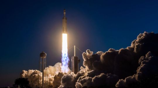
GOES-U Launches to Space by NASA on The Commons Via Flickr: A SpaceX Falcon Heavy rocket carrying the National Oceanic and Atmospheric Administration (NOAA) GOES-U (Geostationary Operational Environmental Satellite U) lifts off from Launch Complex 39A at NASA’s Kennedy Space Center in Florida on Tuesday, June 25, 2024. The GOES-U satellite is the final satellite in the GOES-R series, which serves a critical role in providing continuous coverage of the Western Hemisphere, including monitoring tropical systems in the eastern Pacific and Atlantic oceans. On board GOES-U is a suite of seven instruments for collecting advanced imagery and atmospheric measurements, providing real-time mapping of lightning activity, and detecting approaching space weather hazards. Also onboard for the first time is the compact coronagraph that will observe the Sun’s outermost layer, called the corona, for large explosions of plasma that could produce geomagnetic solar storms. NASA Media Usage Guidelines Credit: NASA/SpaceX Image Number: KSC-20240625-PH-SPX01_0016 Date: June 25, 2024
#NASA#KSC#Kennedy Space Center#LSP#Launch Services Program#GOES-U#Geostationary Operational Environmental Satellite#spacecraft#weather satellite#GSFC#NOAA#National Oceanic and Atmospheric Administration#Advanced Baseline Imager#Magnetometer instrument#SpaceX#Falcon Heavy rocket#Lockheed Martin#L3Harris Technologies#flickr
0 notes
Text
WATCH SPACEX LAUNCH TODAY AT 11:04 pm EST ~ There is More to This Life
SpaceX’s powerful Falcon Heavy rocket will launch for the seventh time ever today, Thursday (July 27), and you can watch the epic action live, according to Mike Wall in a Space.com article posted yesterday. The Falcon Heavy is scheduled to lift off Thursday at 11:04 p.m. EDT (0304 GMT on July 27) from Pad 39A at NASA’s Kennedy Space Center in Florida. You can watch it live here at Space.com,…
View On WordPress
#commercial communications satellite#Earth#Elon Musk#Falcon 9#Falcon Heavy#geostationary orbit#June 27#Jupiter 3#Kennedy Space Center#NASA#record-breaking mission#rocket#satellite#space#SpaceX#SpaceX Falcon
0 notes
Text
This harkens back (forward? widdershins?) to my favorite passage in the entire trilogy:


One of many sentences in HtN that keep me up at night
#I have a normal amount of feelings about this#I could write a whole book on the theme of falling in The Locked Tomb#Does tazmuir know about geostationary orbits#It's infinite self-sustaining freefall#“I don’t like the part just before you let go and I don’t like the part where you hit the floor#but I like the letting go.”
2K notes
·
View notes
Text
#Self-Defense Forces#SpaceX#Starlink#Satellite constellation#Trial basis#Japanese government sources#Communication capabilities#China#Russia#Attack satellites#High-speed communication service#U.S. space development company#U.S. military satellites#X-band communication satellites#Geostationary orbit#Private-sector satellite constellation#Ground-based jammers#Contingency#Operational issues#Military technology#National security#japan#tokyo#investment
0 notes
Text
静止軌道上空のあなたへ | cosmomule
#cosmomule#静止軌道上空のあなたへ#to you on geostationary orbit#my post#musik#one of the best things ive heard in a while#cosmomules EPs are incredible along with everything else he's been a part of
2 notes
·
View notes
Text

That's a lot higher frequency ranges than what I'm capable of right now seeing as it's in the gigahertz ranges, these images were received via the APT signal at 137mHz.
I do most definitely intend to build a helical antenna for the delicious circular polarized signals but I'll need to source a proper dish first too!
I do suppose I can try and see if I can get one of the linear bands like HRI 1694.5 but I'm not holding out on it, my current setup is scuffed lmao
doxxing myself

guess who bought an SDR and has been trying hard to receive signals from weather satellites
here's my best one yet, NOAA 19 coming in from norway and leaving over morocco, with france, ireland, bits of denmark, sweden, italy, africa, and most of the main european area visible!
Now to make an antenna setup that doesn't require me pinching down on wires to make a broken connection work right lmao
#I'm definitely interested in seeing if I can get that one too#geostationary satellites are super cool and definitely make for way easier reception than the polar orbit ones#the big one I wanna try and see is transit 5b-5 though
31 notes
·
View notes
Text
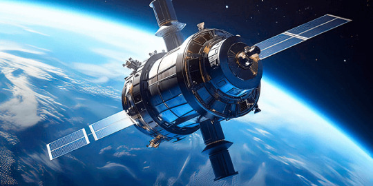
Connecting the World: Telecommunications Satellites Enhance Global Communication Networks

In an increasingly interconnected world, the role of telecommunications has never been more critical. The rapid growth of digital communication technologies has significantly transformed the way we live, work, and interact with one another. At the heart of this transformation lies a technology that orbits high above us – telecommunications satellites. These sophisticated machines play a pivotal role in bridging gaps across continents, bringing people closer, and enabling the seamless exchange of information on a global scale.
Telecommunications satellites are the backbone of modern communication networks. These satellites are designed to transmit signals across vast distances, overcoming the limitations of terrestrial infrastructure. By relaying signals from one point on the Earth's surface to another, they enable instant communication, regardless of geographical barriers. This capability has revolutionized various sectors, from media broadcasting to internet services, emergency communications, and more.
The Evolution of Telecommunications Satellites
The journey of telecommunications satellites began in the mid-20th century. Early experiments with satellite communication laid the groundwork for what would become a global network. The launch of the first artificial satellite, Sputnik, in 1957 marked the dawn of the space age. However, it wasn't until the launch of the first geostationary satellite in 1965 that the true potential of satellite communication was realized. This satellite, positioned in a fixed location relative to the Earth's surface, could provide continuous coverage to a specific region, paving the way for real-time communication across the globe.
Since then, telecommunications satellites have evolved dramatically. Advances in technology have led to the development of more sophisticated satellites with greater capacity, reliability, and efficiency. Modern satellites are equipped with high-powered transponders, enabling them to handle large volumes of data transmission. These advancements have expanded the capabilities of satellite communication, making it an indispensable part of the global communication network.
How Telecommunications Satellites Work
The operation of telecommunications satellites is based on the principles of radio frequency transmission. These satellites receive signals from ground-based stations, amplify them, and retransmit them back to other ground stations. The process involves several key components:
Uplink: The transmission of signals from a ground station to the satellite. This is typically done using high-frequency radio waves.
Transponder: The component within the satellite that receives the uplink signal, amplifies it, and changes its frequency for retransmission.
Downlink: The transmission of signals from the satellite back to a ground station. This completes the communication loop, allowing the original signal to reach its intended destination.
Satellites are positioned in different orbits depending on their specific functions. Geostationary satellites, which orbit at approximately 35,786 kilometers above the equator, provide continuous coverage to specific regions. Low Earth orbit (LEO) satellites, positioned much closer to the Earth's surface, offer lower latency and are often used for services requiring real-time data transmission, such as internet connectivity.
Impact on Global Communication Networks
The impact of telecommunications satellites on global communication networks is profound. They have enabled a level of connectivity that was previously unimaginable, facilitating the seamless exchange of information across vast distances. Here are some key areas where their impact is most evident:
Media and Broadcasting
Telecommunications satellites have revolutionized the media and broadcasting industry. They enable the transmission of television and radio signals to remote and underserved areas, ensuring that people worldwide have access to information and entertainment. Live broadcasts of major events, such as sports competitions and political speeches, are made possible through satellite technology, allowing audiences to experience these moments in real time.
Internet Connectivity
In many parts of the world, terrestrial internet infrastructure is either insufficient or nonexistent. Telecommunications satellites provide a vital solution to this problem by offering internet connectivity to remote and rural areas. Satellite internet services have become increasingly popular, providing reliable and high-speed internet access to communities that were previously disconnected.
Emergency Communications
During natural disasters and emergencies, terrestrial communication networks are often disrupted. Telecommunications satellites play a crucial role in providing emergency communication services, ensuring that rescue and relief operations can be coordinated effectively. Satellite phones and portable satellite communication devices are essential tools for first responders and humanitarian organizations, enabling them to maintain communication in even the most challenging conditions.
Global Navigation Systems
Telecommunications satellites are also integral to global navigation systems. They provide the precise timing and positioning data required for navigation and location-based services. These systems are essential for various applications, including aviation, maritime, and land transportation, as well as for personal navigation devices used by millions of people worldwide.
Future Trends and Developments
The field of telecommunications satellites is continually evolving, driven by advancements in technology and increasing demand for connectivity. Several trends and developments are shaping the future of this industry:
High Throughput Satellites (HTS)
High throughput satellites represent a significant advancement in satellite technology. These satellites offer substantially increased data transmission capacity, enabling faster and more reliable communication services. HTS technology is particularly beneficial for providing broadband internet access to remote and underserved areas, helping to bridge the digital divide.
Constellations of LEO Satellites
One of the most exciting developments in satellite communication is the deployment of constellations of low Earth orbit satellites. These constellations consist of hundreds or even thousands of small satellites working together to provide global coverage. LEO constellations offer lower latency and higher data transfer rates compared to traditional geostationary satellites, making them ideal for applications such as internet of things (IoT) connectivity and real-time data services.
Advances in Satellite Manufacturing
Advances in satellite manufacturing are making it possible to produce smaller, more cost-effective satellites. These miniaturized satellites, often referred to as smallsats or cubesats, can be launched in large numbers, providing flexible and scalable communication solutions. The reduced cost of manufacturing and launching these satellites is driving innovation and enabling new players to enter the market.
Integration with Terrestrial Networks
The integration of satellite communication with terrestrial networks is another key trend. Hybrid networks that combine satellite and terrestrial technologies can offer seamless connectivity, ensuring that users have access to reliable communication services regardless of their location. This integration is particularly important for providing consistent internet coverage in areas with challenging terrain or sparse infrastructure.
Challenges and Considerations
While telecommunications satellites offer numerous benefits, there are also challenges and considerations to address. One of the primary challenges is the cost associated with launching and maintaining satellites. The development, launch, and operation of satellites require significant investment, which can be a barrier for some organizations.
Additionally, the increasing number of satellites in orbit raises concerns about space debris and collision risks. Ensuring the long-term sustainability of space activities requires careful management of satellite operations and the implementation of measures to mitigate the risk of space debris.
Conclusion
Telecommunications satellites have fundamentally transformed global communication networks, enabling instant connectivity and information exchange across vast distances. From media broadcasting and internet connectivity to emergency communications and global navigation, the impact of these satellites is far-reaching and profound.
As technology continues to advance, the future of telecommunications satellites looks promising. High throughput satellites, LEO constellations, and advancements in satellite manufacturing are set to further enhance the capabilities of satellite communication. By overcoming challenges and embracing innovation, telecommunications satellites will continue to play a crucial role in connecting the world, bridging gaps, and enabling a more connected and informed global community.
In a world where connectivity is essential, telecommunications satellites stand as a testament to human ingenuity and the relentless pursuit of progress. They embody the spirit of exploration and innovation, bringing people closer together and fostering a sense of global unity. As we look to the future, the continued evolution of telecommunications satellites promises to unlock new possibilities and drive the next wave of communication advancements.
196 notes
·
View notes