#elpaso&southwesternrailroad
Explore tagged Tumblr posts
Text


Light Engine
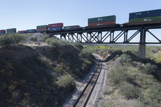
We are off East Marsh Station Road in Davidson Canyon, near Vail, Arizona—southeast of Tucson by thirty miles. A lone locomotive, running eastward, is on the former Southern Pacific line where the former El Paso and Southwestern Railroad flies overhead.
As stated in the previous post (with Sunset Limited), the EP&SW came through here in 1911 or so while the SP was built in 1880. The younger road would be purchased by the Southern Pacific in 1924 and fully absorbed into its system in 1955.
[Note: my two posts at this location are out of order: this light engine actually surprised me and rolled by just prior to that of the Sunset Limited.]
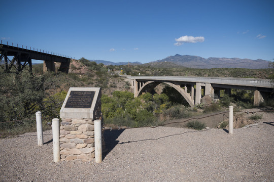
Also mentioned in the previous post: in addition to the two railroads here, an historical marker states that the adjacent Cienega Bridge (not pictured), built in 1921, is listed on the National Register of Historic Places.
Land acknowledgement: O’odham Jewed, Sobaipuri, Tohono O’odham, Hohokam.
Two images by Richard Koenig; taken May 2nd 2024.
#railroadhistory#railwayhistory#southernpacificrailroad#southernpacific#sunsetroute#unionpacific#unionpacificrailroad#ep&sw#elpaso&southwestern#cienegabridge#eastmarshstationroad#elpaso&southwesternrailroad#oodhamjewed#sobaipuri#tohonooodham#hohokam
47 notes
·
View notes
Photo
Re-upping a few posts from my brief time in the Gadsden Purchase area a little over four years ago.
Update: four years ago, I had assumed both lines here were of the Southern Pacific, and they would be in time (see below), but originally the line flying over (with train) was once the El Paso & Southwestern Railroad. I was correct in thinking the curvier line (sans train) was the original Southern Pacific (built 1880 or so).
This portion of the EP&SW was built quite late (in railroad terms), with crews working at this location in the autumn of 1911 or so. The railroad would make Tucson its western terminus the next year with festivities on October 31st 1912 (106 years prior, nearly to the day, of me taking these pictures).
The El Paso & Southwestern Railroad would be purchased by the Southern Pacific in 1924 and fully absorbed into its system in 1955.


(Original) Sunset Route, Part One
I believe this location, off East Marsh Station Road in Davidson Canyon, southeast of Tucson, is where a newer alignment of the Sunset Route flies over that of the original.
In addition, an historical marker states that the adjacent Cienega Bridge, built in 1921, is listed on the National Register of Historic Places.
Three images by Richard Koenig; taken October 26th 2018.
#railroadhistory#railwayhistory#southernpacific#sunsetroute#unionpacific#ep&sw#elpaso&southwestern#cienegabridge#eastmarshstationroad#elpaso&southwesternrailroad
106 notes
·
View notes