#action on lake borgne
Text
I did not put together a post for War of 1812 Wednesday in a timely manner, but while it's still Wednesday and the 14th of December in my timezone: it's the 208th anniversary of the Battle of Lake Borgne! A British victory for the Royal Navy in Louisiana, although the subsequent Battle of New Orleans didn't go so well on land.
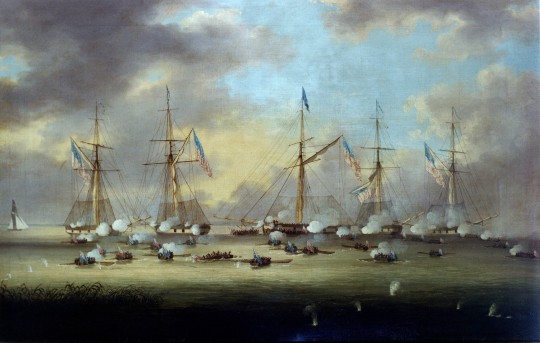
British and American Gunboats in Action on Lake Borgne, 14 December 1814, Thomas L. Hornbrook (Wikimedia Commons).
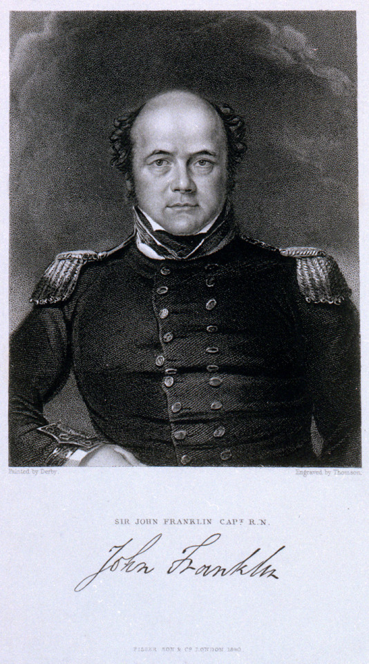
Sir Alexander Cochrane (uncle of Lord Thomas Cochrane) was in charge of the British fleet, but mostly I remember the Battle of Lake Borgne for a lieutenant of HMS Bedford who was wounded in the action: John Franklin.
A lot of War of 1812 connections for the 1845 Franklin Expedition: Franklin himself, a veteran, and HMS Terror (which bombed Stonington, Connecticut amongst other places during the conflict).
The other officers and crew of the Franklin Expedition were much too young for the War of 1812, but if you look into their service records you can find a few degrees of separation. Henry TD Le Vesconte served on HMS Endymion (1797) as a midshipman—the same ship that defeated USS President in the War of 1812. Graham Gore was on HMS Albion, once Sir George Cockburn's flagship in the Chesapeake Campaign of the War of 1812.
#War of 1812 Wednesday#war of 1812#sir john franklin#franklin expedition#battle of lake borgne#royal navy#age of sail#henry thomas dundas le vesconte#henry le vesconte#graham gore#military history#special interest mashup ahoy!#hms terror#naval history
21 notes
·
View notes
Photo

British and American Gunboats in Action on Lake Borgne, 14 December 1814, by Thomas Hornbrook, mid 19th century
During the preparation for the attack on New Orleans during the War of 1812, one of the obstacles for the British to overcome was five American gunboats moored on Lake Borgne, a sea lake to the east. Since the waters were too shallow to permit men-of-war to get within range, the attack was made by boats of the fleet.
This force consisted of 42 launches, each with a carronade mounted in the bow, and carrying 980 seamen and marines. The five American gunboats were commanded by Lieutenant Thomas Catesby Jones and manned by 182 men. When Jones's vessel drifted on the current a hundred yards nearer to his attackers, his was the first to be in action. He was boarded by sailors from the barge of Commander Nicholas Lockyer, the British officer in charge of the attack.
The Americans resisted fiercely and had the advantage of height and anti-boarding netting. Lockyer was wounded, his number-two killed and his barge suffered heavy loss. When a second took its place it was sunk but by sheer weight of numbers the British boats prevailed. They cut away the nettings and subsequently all the gunboats were taken. 41 Americans and 94 British were killed or wounded.
9 notes
·
View notes
Link
The National Weather Service has issued a hurricane watch for an area that includes Diamondhead, MS. At 1:00 PM CDT, the center of Tropical Storm Sally was located near latitude 27.7 North, longitude 85.5 West. Sally is moving toward the west-northwest near 12 mph (19 km/h), and a west-northwestward or northwestward motion is expected through Monday. A decrease in forward speed and a turn toward the north-northwest is forecast on Monday night, and slow north-northwestward motion is expected Tuesday. On the forecast track, the center of Sally will move over the eastern Gulf of Mexico today, move over the north-central Gulf of Mexico tonight and Monday, and approach the north-central Gulf Coast within the hurricane warning area late Monday and Monday night. Sally is expected to move farther inland over southeastern Louisiana or southern Mississippi on Tuesday and Tuesday night. Maximum sustained winds are near 60 mph (95 km/h) with higher gusts. Strengthening is expected over the next day or so, and Sally is forecast to become a hurricane on Monday, with some additional strengthening possible before landfall Monday night. Tropical-storm-force winds extend outward up to 90 miles (150 km) primarily to the east of the center. The latest minimum central pressure estimated from data from a NOAA reconnaissance aircraft is 998 mb (29.48 inches). A Storm Surge Warning is in effect for... * Port Fourchon Louisiana to the Mississippi/Alabama Border * Lake Pontchartrain, Lake Maurepas, and Lake Borgne A Hurricane Warning is in effect for... * Morgan City Louisiana to Ocean Springs Mississippi * Lake Pontchartrain and Lake Maurepas including metropolitan New Orleans A Storm Surge Watch is in effect for... * Mississippi/Alabama Border to the Alabama/Florida Border A Hurricane Watch is in effect for... * East of Ocean Springs to the Alabama/Florida Border A Tropical Storm Warning is in effect for... * East of Ocean Springs to Indian Pass * Intracoastal City Louisiana to west of Morgan City A Tropical Storm Watch is in effect for... * Indian Pass to Ochlockonee River Florida A Storm Surge Warning means there is a danger of life-threatening inundation, from rising water moving inland from the coastline, during the next 36 hours in the indicated locations. For a depiction of areas at risk, please see the National Weather Service Storm Surge Watch/Warning Graphic, available at hurricanes.gov. This is a life-threatening situation. Persons located within these areas should take all necessary actions to protect life and property from rising water and the potential for other dangerous conditions. Promptly follow evacuation and other instructions from local officials. A Hurricane Warning means that hurricane conditions are expected omewhere within the warning area. A warning is typically issued 6 hours before the anticipated first occurrence of tropical-storm-force winds, conditions that make outside reparations difficult or dangerous. Preparations to protect life and property should be rushed to completion. A Tropical Storm Warning means that tropical storm conditions are xpected somewhere within the warning area within 36 hours. A Storm Surge Watch means there is a possibility of life-theatening inundation, from rising water moving inland from the oastline, in the indicated locations during the next 48 hours. For a depiction of areas at risk, please see the National Weather ervice Storm Surge Watch/Warning Graphic, available at hurricanes.gov. A Hurricane Watch means that hurricane conditions are possible within the watch area. A Tropical Storm Watch means that tropical storm conditions are possible within the watch area, in this case within 12 to 24 hours. For storm information specific to your area, including possible inland watches and warnings, please monitor products issued by your local National Weather Service forecast office.
0 notes
Link
227 WTNT33 KNHC 270253 TCPAT3 BULLETIN Hurricane Laura Advisory Number 29 NWS National Hurricane Center Miami FL AL132020 1000 PM CDT Wed Aug 26 2020 ...EXTREMELY DANGEROUS HURRICANE LAURA CLOSING IN ON THE NORTHWEST GULF COAST... ...CATASTROPHIC STORM SURGE, EXTREME WINDS, AND FLASH FLOODING EXPECTED TONIGHT AND EARLY THURSDAY... SUMMARY OF 1000 PM CDT...0300 UTC...INFORMATION ----------------------------------------------- LOCATION...29.0N 93.2W ABOUT 75 MI...120 KM S OF LAKE CHARLES LOUISIANA ABOUT 75 MI...120 KM SE OF PORT ARTHUR TEXAS MAXIMUM SUSTAINED WINDS...150 MPH...240 KM/H PRESENT MOVEMENT...NNW OR 340 DEGREES AT 15 MPH...24 KM/H MINIMUM CENTRAL PRESSURE...939 MB...27.73 INCHES WATCHES AND WARNINGS -------------------- CHANGES WITH THIS ADVISORY: None. SUMMARY OF WATCHES AND WARNINGS IN EFFECT: A Storm Surge Warning is in effect for... * Freeport Texas to the Mouth of the Mississippi River A Hurricane Warning is in effect for... * San Luis Pass Texas to Intracoastal City Louisiana A Tropical Storm Warning is in effect for... * Sargent Texas to San Luis Pass * East of Intracoastal City Louisiana to the Mouth of the Mississippi River A Hurricane Watch is in effect for... * East of Intracoastal City to west of Morgan City Louisiana A Storm Surge Warning means there is a danger of life-threatening inundation, from rising water moving inland from the coastline in the indicated locations. For a depiction of areas at risk, please see the National Weather Service Storm Surge Watch/Warning Graphic, available at hurricanes.gov. This is a life-threatening situation. Persons located within these areas should take all necessary actions to protect life and property from rising water and the potential for other dangerous conditions. Promptly follow evacuation and other instructions from local officials. A Hurricane Warning means that hurricane conditions are expected somewhere within the warning area. Preparations to protect life and property should be rushed to completion. A Hurricane Watch means that hurricane conditions are possible within the watch area. A Tropical Storm Warning means that tropical storm conditions are expected somewhere within the warning area. For storm information specific to your area, including possible inland watches and warnings, please monitor products issued by your local National Weather Service forecast office. DISCUSSION AND OUTLOOK ---------------------- At 1000 PM CDT (0300 UTC), the center of Hurricane Laura was located near latitude 29.0 North, longitude 93.2 West. Laura is moving toward the north-northwest near 15 mph (24 km/h). A turn toward the north is expected by early Thursday, and a northward motion should continue through the day. A northeastward to east-northeastward motion is expected Thursday night and Friday. On the forecast track, Laura will make landfall along the southwest Louisiana coast within the next few hours and move inland within that area early Thursday. The center of Laura is forecast to move over northwestern Louisiana on Thursday, across Arkansas Thursday night, and over the mid-Mississippi Valley on Friday. Maximum sustained winds are near 150 mph (240 km/h) with higher gusts. No significant change in strength is likely before landfall. Rapid weakening is expected after Laura moves inland. Hurricane-force winds extend outward up to 60 miles (95 km) from the center and tropical-storm-force winds extend outward up to 205 miles (335 km). A sustained wind of 43 mph (69 km/h) and a gust to 49 mph (80 km/h) were recently reported by a National Ocean Service station at Texas Point, Texas, at Sabine Pass. A wind gust to 58 mph (93 km/h) was recently reported at Cameron, Louisiana. The minimum central pressure estimated from Air Force and NOAA Hurricane Hunter observations is 939 mb (27.73 inches). HAZARDS AFFECTING LAND ---------------------- Key messages for Laura can be found in the Tropical Cyclone Discussion under AWIPS header MIATCDAT3 and WMO header WTNT43 KNHC. Storm surge and tropical-storm-force winds will arrive within the warning areas well in advance of Laura's center. All preparations to protect life and property should be rushed to completion in the next few hours. STORM SURGE: The combination of a dangerous storm surge and the tide will cause normally dry areas near the coast to be flooded by rising waters moving inland from the shoreline. The water could reach the following heights above ground somewhere in the indicated areas if the peak surge occurs at the time of high tide... Johnson Bayou LA to Rockefeller Wildlife Refuge including Calcasieu Lake...15-20 ft Sea Rim State Park TX to Johnson Bayou LA including Sabine Lake...10-15 ft Rockefeller Wildlife Refuge to Intracoastal City LA...10-15 ft Intracoastal City LA to Morgan City including Vermilion Bay...8-12 ft Port Bolivar TX to Sea Rim State Park...6-9 ft Morgan City LA to Mouth of the Mississippi River...4-7 ft Freeport TX to Port Bolivar including Galveston Bay...2-4 ft Mouth of the Mississippi River to Ocean Springs MS including Lake Borgne...1-3 ft Lake Pontchartrain and Lake Maurepas...1-3 ft The deepest water will occur along the immediate coast near and to the right of the landfall location, where the surge will be accompanied by large and destructive waves. Unsurvivable storm surge with large and destructive waves will cause catastrophic damage from Sea Rim State Park, Texas, to Intracoastal City, Louisiana, including Calcasieu and Sabine Lakes. This surge could penetrate up to 40 miles inland from the immediate coastline, and flood waters will not fully recede for several days after the storm. Surge-related flooding depends on the relative timing of the surge and the tidal cycle, and can vary greatly over short distances. For information specific to your area, please see products issued by your local National Weather Service forecast office. WIND: Hurricane conditions are expected in the hurricane warning area tonight and Thursday morning, with catastrophic wind damage expected where Laura's eyewall moves onshore. Tropical storm conditions are moving onshore along the coast of Louisiana within the tropical storm warning area and are expected to spread northward within the warning areas overnight. Hurricane-force winds and damaging wind gusts are also expected to spread well inland into portions of eastern Texas and western Louisiana early Thursday. RAINFALL: Through Friday, Laura is expected to produce the following rainfall totals: Across the northwestern Gulf Coast from far southwest Louisiana and the Golden Triangle of Southeast Texas: 8 to 12 inches with isolated totals of 18 inches. Across central and the rest of western Louisiana into far eastern Texas: 5 to 10 inches with isolated totals of 15 inches. Across much of Arkansas: 3 to 7 inches with isolated totals of 10 inches. This rainfall will cause widespread flash and urban flooding, small streams and creeks to overflow their banks, and minor to moderate freshwater river flooding. By Friday into Saturday, Laura is expected to produce the following rainfall totals: Across the mid-Mississippi and portions of the Tennessee Valley, Lower Ohio Valley, and central Appalachians: 2 to 4 inches with isolated maximum amounts of 6 inches. This rainfall may lead to flash and urban flooding and rapid rises on small streams. Across the Mid-Atlantic Region: 1 to 3 inches. TORNADOES: Several tornadoes are expected tonight over Louisiana, far southeast Texas, and southwestern Mississippi. The risk for tornadoes will continue on Thursday across Louisiana, Arkansas, and western Mississippi. SURF: Swells produced by Laura are affecting the U.S. Gulf coast from the west coast of Florida to Texas and northeastern Mexico. These swells are likely to cause life-threatening surf and rip current conditions. Please consult products from your local weather office. NEXT ADVISORY ------------- Next intermediate advisory at 100 AM CDT. Next complete advisory at 400 AM CDT. $$ Forecaster Pasch
0 notes
Text
Battle of Bay St. Louis anniversary
Battle of Bay St. Louis anniversary
It’s almost been 205 years since the Battle of Bay St. Louis.
That’s when officials in New Orleans received warnings from Pensacola that British warships were closing in on the area.
The commander dispatched a fleet to the passes Mariana and Christiana to watch British action in the Mississippi Sound. The Battle of Bay St. Louis and Battle of Lake Borgne delayed the British fleet from arriving in…
View On WordPress
0 notes
Text
War of 1812 Wednesday: A Glorious First of June
I periodically bring up Sir John Franklin’s status as a War of 1812 veteran, but I have assumed that it’s more of a piece of trivia than anything else—a footnote in his career even if he took a bullet to his shoulder as part of raiding party at the Battle of Lake Borgne.
Franklin was a midshipman on HMS Intrepid during the circumnavigation of Australia, he was at the Battle of Trafalgar in the thick of the action (narrowly missing a French sniper’s bullet), and of course he became famous for his polar exploits long before the 1845 Franklin Expedition. I didn’t think that Franklin would be dwelling much on the War of 1812, especially not late in his career in the 1840s. But I was wrong!
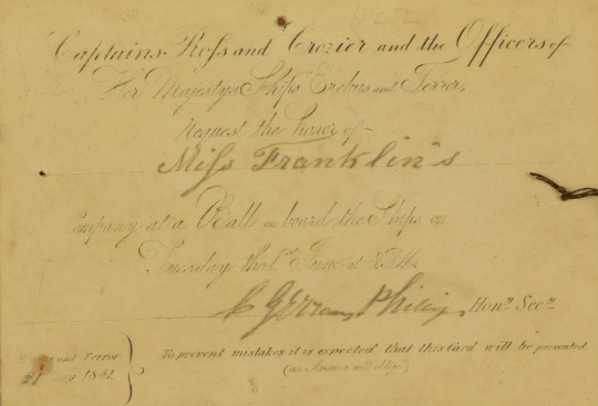
Invitation card to a ball aboard HMS Erebus and HMS Terror, hosted by James Clark Ross and Francis Crozier, 1841 (Derbyshire Record Office).
Sir John Franklin was Lieutenant Governor of Van Diemen’s Land when Erebus and Terror wintered there in 1841, and of course he attended the ball. Although the date of 1st June appears to be a coincidence and not selected for any special significance, noted Franklinheads @explorersaremadeofhope @kljjfnotes and Olga Kimmins of The Thousandth Part brought it to my attention that it acquired a Glorious First of June title.
The usual “Glorious First of June” in the Royal Navy is the Fourth Battle of Ushant in 1794, but Sir John Franklin had a different battle in mind:
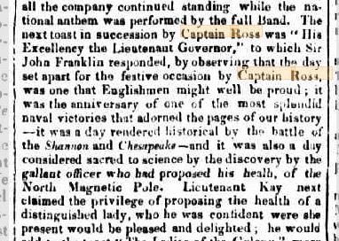
[all the company continued standing while the national anthem was performed by the full Band. The next toast in succession by Captain Ross was “His Excellency the Lieutenant Governor,” to which Sir John Franklin responded, by observing that the day set apart for the festive occasion by Captain Ross, was one that Englishmen might well be proud; it was the anniversary of one of the most splendid naval victories that adorned the pages of our history—it was a day rendered historical by the battle of the Shannon and Chesapeake—and it was also a day considered sacred to science by the discovery by the gallant officer who had proposed his health, of the North Magnetic Pole.]
Franklin hears the first of June and immediately goes to HMS SHANNON VS. USS CHESAPEAKE?! I was not expecting that at all, and have give Franklin more credit for his taste.

The celebrated engagement during which H.M.S. “Shannon” captured the American frigate “Chesapeake”, 1st June 1813, Thomas Whitcombe (Wikimedia Commons).
#War of 1812 Wednesday#war of 1812#age of sail#sir john franklin#james clark ross#.uss chesapeake#hms shannon#glorious first of june#north magnetic pole#royal navy#naval history#polar#thomas whitcombe#naval battle#art#the sea#military history
19 notes
·
View notes
Photo

British and American Gunboats in Action on Lake Borgne, 14 December 1814, by Thomas Lyde Hornbrook Early to mid 19th century
During the preparation for the attack on New Orleans during the Anglo-American War of 1812-14, one of the obstacles for the British to overcome was five American gunboats moored on Lake Borgne, a sea lake to the east. Since the waters were too shallow to permit men-of-war to get within range, the attack was made by boats of the fleet.
This force consisted of 42 launches, each with a carronade mounted in the bow, and carrying 980 seamen and marines. The five American gunboats were commanded by Lieutenant Thomas Catesby Jones and manned by 182 men. When Jones's vessel drifted on the current a hundred yards nearer to his attackers, his was the first to be in action. He was boarded by sailors from the barge of Commander Nicholas Lockyer, the British officer in charge of the attack. The Americans resisted fiercely and had the advantage of height and anti-boarding netting.
Lockyer was wounded, his number-two killed and his barge suffered heavy loss. When a second took its place it was sunk but by sheer weight of numbers the British boats prevailed. They cut away the nettings and subsequently all the gunboats were taken. 41 Americans and 94 British were killed or wounded.
28 notes
·
View notes
Photo

British and American Gunboats in Action on Lake Borgne, 14 December 1814, by Thomas Lyde Hornbrook (1780–1850)
During the preparation for the attack on New Orleans during the Anglo-American War of 1812 to 1814, one of the obstacles for the British to overcome was five American gunboats moored on Lake Borgne, a sea lake to the east. Since the waters were too shallow to permit men-of-war to get within range, the attack was made by boats of the fleet. This force consisted of 42 launches, each with a carronade mounted in the bow, and carrying 980 seamen and marines.
The five American gunboats were commanded by Lieutenant Thomas Catesby Jones and manned by 182 men. When Jones’s vessel drifted on the current a hundred yards nearer to his attackers, his was the first to be in action. He was boarded by sailors from the barge of Commander Nicholas Lockyer, the British officer in charge of the attack. The Americans resisted fiercely and had the advantage of height and anti-boarding netting. Lockyer was wounded, his number two killed and his barge suffered heavy loss. When a second took its place it was sunk but by sheer weight of numbers the British boats prevailed. They cut away the nettings and subsequently all the gunboats were taken. 41 Americans and 94 British were killed or wounded.
15 notes
·
View notes
Last Seen Blogs

mirtapejic
Mirta Pejic Portfolio

rebelren
pardon me while i have a strange interlude

dailysipcalculator
Untitled

enbythoughts
enbythoughts

missmahnia
Monstrously Kawaii