#USGS Floods
Explore tagged Tumblr posts
Visit Tumblr Blog
Explore Tumblr blogs with no restrictions, modern design and the best experience.
Last Seen Tumblr Blogs


Fun Fact
China blocked Tumblr because of pornography and censorship problems in 2013.
Text

Flooding_in_Cedar_Rapids,_IA_(2593483361).jpg
#wikimedia commons#1990s#1998#1998 floods in the United States#USGS Floods#CC-Zero#Flickr images reviewed by FlickreviewR 2#PD USGS#Files uploaded by Artix Kreiger#Images from the United States Geologic Survey Flickr stream
1 note
·
View note
Text
Thousands are feared dead after a powerful 7.7 magnitude earthquake rocked Southeast Asia on Friday, bringing down a towering skyscraper in Thailand and toppling buildings, including a mosque, in neighboring Myanmar.
Harrowing scenes emerged of bodies being lined up in the rubble as rescuers scoured for survivors from the midday quake, whose epicenter was detected near Mandalay, Myanmar’s second-largest city.
Although the extent of death and destruction wasn’t immediately clear, the US Geological Survey (USGS) issued a red alert — estimating that deaths could range between 1,000 and 10,000.
“High casualties and extensive damage are probable and the disaster is likely widespread,” the federal agency warned, noting that “past red alerts have required a national or international response.”
At least 144 were quickly confirmed dead in Myanmar — one of the world’s poorest countries — where photos and video from two hard-hit cities showed extensive damage.
At least 732 were injured in the nation, according to officials, who declared a state of emergency in the capital city of Naypyidaw.
“Casualties are expected to rise,” said Senior Gen. Min Aung Hlaing, commander in chief of Myanmar’s armed forces. “Buildings have collapsed in several areas, and rescue operations are underway.”
The destruction spread hundreds of miles from the epicenter, including in neighboring Thailand, where an under-construction skyscraper crashed down in the capital Bangkok, killing at least eight people, Thai authorities said.
At least 80 more remained trapped under debris from the collapsed building Friday night local time, according to according to Thailand’s Defense Minister Phumtham Wechayachai.
Dramatic video circulating on social media showed the 30-story building with a crane on top crumbling into a cloud of dust near the city’s popular Chatuchak market as screaming onlookers ran from the scene.
Numerous people were pulled from the rubble, while dozens more were unaccounted for, Wechayachai said, noting that the site was still too unstable for rescue crews.
Elsewhere in Bangkok, people could be seen running out onto the streets in panic — many of them hotel guests in bathrobes and swimsuits as water cascaded down from an elevated pool at a luxury hotel, witnesses said.
Bangkok’s governor Chadchart Sittipunt said at least two other deaths had been confirmed in Thailand’s capital.
In Myanmar, at least three were killed in the town of Taungoo when a mosque partially collapsed.
Local media reported that at least two people also died and 20 others were injured after a hotel collapsed in the city of Aung Ban.
USGS said the deadly quake, which struck at lunchtime, was of 7.7 magnitude and at a depth of 6.2 miles.
The epicenter was detected near Mandalay — Myanmar’s second-largest city — and was followed by a strong 6.4 magnitude aftershock, according to officials.
Bangkok’s city authorities declared the capital city a disaster-stricken area, saying they needed to assess and monitor damaged areas, as well as assist people who might still be at risk.
The greater Bangkok area is home to more than 17 million people, many of whom live in high-rise apartments.
The sound of sirens echoed throughout the city and vehicles flooded the street in the aftermath, leaving some of the city’s already congested streets gridlocked.
Fraser Morton, a tourist from Scotland, said he was in a shopping mall when the tremor hit.
“All of a sudden the whole building began to move. Immediately there was screaming and a lot of panic,” he said.
“I just started walking calmly at first but then the building started really moving, yeah, a lot of screaming, a lot of panic, people running the wrong way down the escalators, lots of banging and crashing inside the mall.”
“I got outside and then looked up at the building and the whole building was moving, dust and debris, it was pretty intense,” he added. “Lots of chaos.”
Paul Vincent, a tourist visiting from England, was at a streetside bar when the quake struck
“The next thing, everybody came on the street, so there was a lot of screaming and panicking, which obviously made it a lot worse,” he said.
When he came onto the street himself, he recalled seeing a high-rise building swaying as water gushed down from a rooftop pool.
“When I saw the building, oh my God, that’s when … it hit me,” he said.
“There was people crying in the streets and, you know, the panic was horrendous really.”
Myanmar’s ruling military, too, declared a state of emergency in multiple regions in the wake of the earthquake, but with the country in the midst of a prolonged bloody civil war it wasn’t immediately clear how help would get to many regions.
In Mandalay, the earthquake damaged part of the former royal palace and buildings, according to a slew of social media videos and photos.
“We all ran out of the house as everything started shaking. I witnessed a five-story building collapse in front of my eyes. Everyone in my town is out on the road and no one dares to go back inside buildings,” one witness told Reuters.
A 90-year-old bridge collapsed in the nearby Sagaing region, while some sections of the highway connecting Mandalay and Myanmar’s largest city, Yangon, were also damaged.
In the capital Naypyitaw, the quake damaged religious shrines and some homes.
12 notes
·
View notes
Text
‼️‼️STOP SCROLLING AND READ THIS PLEASE‼️‼️
In brazil, there's been having a lot of floods in the southern region of the country, more specifically in the state of Rio Grande do Sul

Every day people are dying , cities are submerged, a single city was erased from the map for being totally underwater.

"Sadly the city of Eldorado RS, doesn't exist anymore - The city was totally covered by water"
Everyday, people have to witness everything they've built get lost admist the water, people have to live with floating bodies of adults, children, toddlers, newborns, animals, dogs, cats, elders, every possible life in these cities are being taken away by the floods.
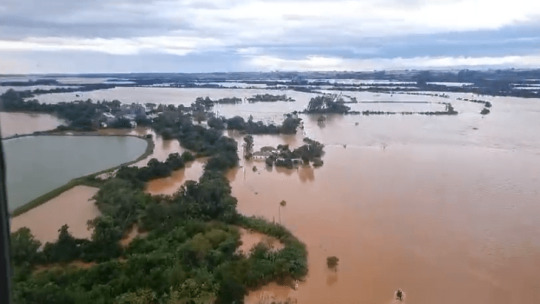
People spend day and night on rooftops, waiting for boats to save them, but not everyone comes out alive.

Hear this audio:
The man says: "Hey Gabriela, deal with what I'll tell you now, there was three children at the boat with me, one of them asked me to pick up a doll that was floating, and I went to grab the doll. It wasn't a doll, it was a baby, a dead baby."
It's the reality of what's happening in Brazil right now when you're reading this.

Sadly, I can't share more than one video here on Tumblr, but theres an audio of a woman thanking her parents for everything, saying she loved them and asking them to take care of her dog Maicon, in the audio, she said she didn't feel her legs, that she felt like she was hallucinating, that the water was almost at her chin, that she was about to die, that her other dog died. After the woman spoke, the sound of the roof breaking and falling was heard in the background, sounds of water splashing, and after the audio was sent, she died, submerged in the ruins of her own underwater house.
We can't do much, but if whoever is seeing this post could donate for help, it would be a step closer to salvation of more and more people.
Here's the link if you want to donate for Rio Grande do Sul: Vakinhahttps://www.vakinha.com.br › a-ma...A Maior Campanha Solidária do RS
https://www.google.com/url?q=https://www.vakinha.com.br/vaquinha/a-maior-campanha-solidaria-do-rs%3F&sa=U&sqi=2&ved=2ahUKEwjAgrybp_yFAxUiHbkGHRWMDbIQFnoECDAQAQ&usg=AOvVaw2z2py3rN07FmWV4NePVuOS
Thanks for reading this post, even if only a few people.
#rio grande do sul#rio grande do sul enchente#rio grande do sul flood#RS#brazil#help Rio grande do sul#help RS#save RS
44 notes
·
View notes
Text
Extremely cool website where you can download historical georeferenced USGS topographic maps and use in GIS software- and you don't need an Esri account download it! The extent of the maps don't go very far outside of the U.S. though
link -> https://livingatlas.arcgis.com/topomapexplorer

Here's a close-up of the grand canyon stitched with four different topo maps made in 1886.
I've been looking at reservoirs and comparing them to see how drastically rivers have changed, along with other natural features that have changed

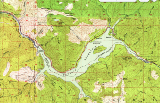
Detroit, OR 1929 (prior to the construction of the Detroit dam) vs 1956 (a few years after the dam's completion). Had no idea that there used to be a railway there, and some buildings were swallowed up when the river was flooded (i.e. the ranger station in the east portion of the lake)
anyhoo, I'm having a blast looking at old maps- going to explore the appalacians to find historic evidence of mountain top removal next, and then examples of eminent domain being used in less affluent and white areas (looking at YOU interstate-10 Bexar county)
#ramblings#I saur this and whent mentol#do I have a GIS tag yet. okay hold on#GIScore#yeah that works
20 notes
·
View notes
Text
Excerpt from this story from Nation of Change:
The United States is grappling with significant water challenges, according to a new report from the U.S. Geological Survey (USGS), which reveals that nearly 30 million Americans live in areas with limited water supplies. The report, based on data from 2010 to 2020, highlights growing concerns over water availability, pollution, and climate change.
“Water availability is an issue everywhere in our country and beyond,” Lori Sprague, USGS national program manager for the water availability assessment, said in a webinar presenting the report. “It raises the question – do we have enough water to sustain our nation’s economy, ecosystems, and drinking water supplies?”
The findings show that approximately 27 million people lived in regions with “a high degree of local water stress” during the assessment period. The report also notes that socially vulnerable populations face a disproportionately higher risk of limited water supplies. Additionally, widespread contamination in aquifers and waterways exacerbates the issue, posing health risks to millions.
“Substantial areas of aquifers that provide about one-third of public water supplies have elevated concentrations of contaminants,” the report noted. These include arsenic, manganese, radionuclides, and nitrate, which disproportionately impact low-income and minority communities reliant on domestic wells for drinking water.
The report underscores the role of climate change in exacerbating water-related challenges. “The amount of water stored within and moving between vapor, liquid, and frozen components of the water cycle is shifting, with substantial consequences for water availability,” the agency warned. Climate impacts such as extreme heat, drought, reduced snow cover, and saltwater intrusion threaten water quality and availability nationwide.
“Climate change impacts water quality as well, with threats posed by rising water temperatures, flooding, and saltwater intrusion in coastal areas,” the report states. These changes also harm aquatic ecosystems, with species like the Arkansas River shiner losing more than 50% of their habitat due to supply and demand imbalances.
4 notes
·
View notes
Text
Gabrielle Canon at The Guardian:
A large earthquake struck the northern California coast on Thursday morning, rattling communities and activating emergency alerts for both shaking and tsunami risks just before 11am local time. Registered as a magnitude 7.0 and originating near the town of Ferndale in Humboldt county, the quake could be felt in San Francisco more than 260 miles (418km) away. Roughly 1.3 million people felt the quake , according to initial estimates provided by the US Geological Survey (USGS), which also reported that risks to human life remained low. “That is an earthquake with quite a lot of energy,” the climate scientist Daniel Swain said of the temblor during a discussion shared on YouTube, adding that it was somewhat similar to other earthquakes that have occurred in the region over the last decade. Cellphones buzzed throughout the region, warning of the incoming shaking and offering ample time to brace and cover. Tsunami alerts also rang out for at least 5.3 million people on the California coast and into Oregon, warning of large waves, strong currents and coastal flooding that could persist through the afternoon.
Following the alert, Bay Area Rapid Transit trains were held and underground stations were cleared as major delays were announced throughout the system, and the San Francisco fire department began evacuating the beaches. The tsunami warning was withdrawn shortly after noon as officials announced the highest risks had subsided. “One challenge with tsunami hazards is you don’t always know what you’re going to get,” Swain said, explaining why the alarm was raised and then abruptly withdrawn. “If it’s going to be big it may be too late to get people out of harm’s way.” But some experts in the emergency management field were critical of how the warnings were rolled out, especially to residents in the San Francisco Bay area. Swain pointed to the potential for warning-fatigue to set in when alerts aren’t adequately explained as some in the region voiced concerns about confusion caused by inconsistent messaging and directions as some warnings were canceled.
A 7.0 magnitude earthquake struck the Northern California coastline today.
I think this is a way of saying it’s God’s punishment for electing Donald Trump.
5 notes
·
View notes
Text
@USGS - "Communities affected by Hurricane #Milton can monitor flooding and weather conditions, often in real-time, using several USGS tools. For links to these resources and more, visit:"
4 notes
·
View notes
Note
“Heavy rains and torrents of cold lava and mud flowing down a volcano's slopes on Indonesia’s Sumatra island triggered flash floods that killed at least 37 people and more than a dozen others were missing, officials said Sunday” That’s a terrible tragedy.
How do cold lavas work?
Here's an explanation by the USGS:
https://www.usgs.gov/programs/VHP/lahars-move-rapidly-down-valleys-rivers-concrete/
4 notes
·
View notes
Text
Heyyo fellow users! Do you want real time, constantly updating maps of flooding, black outs, road closures, land slides, and other important things? Use ArcGIS! NASA, NOAA, USGS, and so many more organizations have free, constantly updating maps through GIS.
These maps also rely on users to report in what satellites and (extremely overwhelmed) ground teams can't evaluate. Rescue teams, hospitals, and other emergency responders use this data to identify safe routes and places of highest need, so if you can provide extra info, please do!
https://www.usgs.gov/special-topics/hurricane-helene
Friday Sept 27:

Millions are without power this morning and underwater.
Do not go into floodwaters. It is not safe. There is debris, animals, pathogens, and god knows what else in the water.
9K notes
·
View notes
Video
youtube
A NodeMCU based flood monitoring system utilizes a NodeMCU microcontroller to continuously measure water levels using an ultrasonic sensor, and when the level exceeds a pre-set threshold, it triggers an alert via an IoT platform (like ThingSpeak) to warn users about potential flooding, typically through a mobile app notification or web interface, allowing for timely response and preventative measures.***********************************************************If You Want To Purchase the Full Working Project KITMail Us: [email protected] Name Along With You-Tube Video LinkWe are Located at Telangana, Hyderabad, Boduppal. Project Changes also Made according to Student Requirementshttp://svsembedded.com/ https://www.svskits.in/ http://svsembedded.in/ http://www.svskit.com/M1: 91 9491535690 M2: 91 7842358459 We Will Send Working Model Project KIT through DTDC / DHL / Blue Dart We Will Provide Project Soft Data through Google Drive1. Project Abstract / Synopsis 2. Project Related Datasheets of Each Component3. Project Sample Report / Documentation4. Project Kit Circuit / Schematic Diagram 5. Project Kit Working Software Code6. Project Related Software Compilers7. Project Related Sample PPT’s8. Project Kit Photos9. Project Kit Working Video linksLatest Projects with Year Wise YouTube video Links152 Projects https://svsembedded.com/ieee_2024.php133 Projects https://svsembedded.com/ieee_2023.php157 Projects https://svsembedded.com/ieee_2022.php135 Projects https://svsembedded.com/ieee_2021.php 151 Projects https://svsembedded.com/ieee_2020.php103 Projects https://svsembedded.com/ieee_2019.php61 Projects https://svsembedded.com/ieee_2018.php171 Projects https://svsembedded.com/ieee_2017.php170 Projects https://svsembedded.com/ieee_2016.php67 Projects https://svsembedded.com/ieee_2015.php55 Projects https://svsembedded.com/ieee_2014.php43 Projects https://svsembedded.com/ieee_2013.php1500 Projects https://www.svskit.com/2025/01/1500-f...***********************************************************1. Flood Warning Systems and Water Level Monitoring with IoT Sensors,2. Automatic Water Level Controller with Message Alerts using GSM and Arduino,3. Gsm Based Flood Monitoring System | Flood Warning Systems And Water Level Monitoring With Gsm,4. IOT based Flood Monitoring System,5. IOT Based Fire Department Alerting System | Arduino Project,6. IOT Based Flood alert system |Psg College of technology| Project demo,7. Flood Monitoring Systems, Water Level Risks, and Early Warnings with Tools.Valarm,8. IoT based flood alert system,9. Early flood detection system and alerting through IOT using ARDUINO,10. Flood alert System Using Arduino Uno | GSM 800,11. Iot based Flood Monitoring System,12. IoT Based Flood Monitoring And Alerting System | Bolt IoT,13. USGS Flood-Monitoring System Agreement Continues,14. IOT based coal mine safety monitoring and alerting system,15. IOT Early Flood Detection,16. Water Monitoring Systems - Water Levels, Floods, Flow Meters, Piezometers w IoT Tools,17. Introducing DipStik: new flood monitoring and alert technology,18. Project: IOT Based Flood Monitoring
0 notes
Text


Dey Road Bridge or High Street Bridge
1335 W. High St.
Defiance. OH 43512
The Dey Road Bridge, a.k.a. High Street Bridge, is a historic truss bridge which carries Dey Road over the Tiffin River 0.35 miles east of U.S. Route 24, west of Defiance in Noble Township, Defiance County, Ohio. Built in the early 1900s, it has been designated a historic site and is listed on the National Register of Historic Places. Dey road was petitioned for as a public road in 1832 In what was then Williams county by Samuel Dey who owned the land to the north of the bridge. In 1835, an early toll bridge across the Tiffin was built at the nearby community of Brunersburg. but it was soon destroyed by a flood and replaced by a bridge built in 1882. The current bridge is a Pratt through truss bridge that was manufactured and built in 1906 by the Massillon Bridge Company of Toledo, Ohio, at a cost of $3,967.50. Built on concrete supports, it is constructed primarily of iron. In 1907, it became a local landmark for surveying purposes when a USGS surveyor placed a benchmark on its northwestern abutment.
The Pratt through truss has diagonals in tension and its verticals in compression, except for the hip verticals adjacent to the inclined end posts. It was the most popular through truss built on highways in the late 19th and early 20th centuries. This one span bridge extends 170 feet and is 16 feet wide. It is set on concrete abutments. The top chords and end posts are composed of two channels a top plate and lacing while the posts have two channels with lacing. Like many of the bridges built during this time it has pin-connections.
This bridge provided a vital Tiffin River crossing for 39 years and was replaced by the prestressed concrete bridge to the south in 1995 at a cost of $1,130,000. Preservation was encouraged by the federal highway administration program known as the "enhancement program” in 1997 at a cost of $237,000. On February 5, 1999, the bridge was listed with the National Register of Historic Places, qualifying because of its historically significant engineering. By that time, the bridge was vacant and not in use. Now known as the "Old Dey Bridge", the bridge is closed to road traffic, although pedestrians are still permitted to use it. The bridge is one of several locations included as points of interest on a proposed Defiance city strategic plan.
0 notes
Text
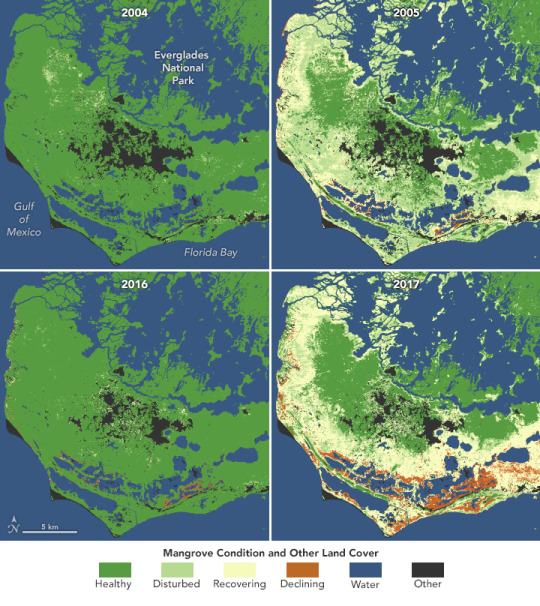
Mangroves Are Losing Their Resilience
Mangrove forests are an iconic feature of the Florida Everglades, their half-submerged roots forming tunnels for kayaking tourists. Beyond their beauty, these trees are important for humans and sea life alike. They stabilize coastlines, slow the movement of tides, store carbon, and help protect against erosion from storm surges. Their tangled root system provides shelter for fish and other organisms.
Mangroves are known to be able to withstand intense flooding, but a new study published in Remote Sensing of Environment found that the increasing frequency and intensity of storms are threatening their resilience. The researchers used data from Landsat satellites to analyze mangrove conditions in Florida from January 1999 through April 2023. They found that as stronger hurricanes hit more often, some mangrove forests are losing their natural capacity to recover.
“Our monitoring has shown a significant increase in the area of mangroves that have lost their natural recovery capacity following recent hurricanes, such as Irma in 2017 and Ian in 2022,” said Zhe Zhu, a co-author of the study and a former member of the USGS-NASA Landsat science team.
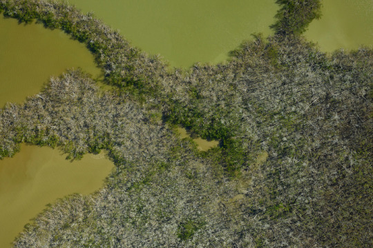
Previous studies have often analyzed a particular disturbance, such as a hurricane, and tracked any losses of mangrove forests after the storm hit. For example, the photo below, acquired by the G-LiHT (Goddard Lidar, Hyperspectral and Thermal Imager), shows mangroves in southern Florida damaged by Hurricane Irma. In the new study, the researchers sought a more complete picture of how mangrove conditions have changed over time, hoping for insight into how these trees recover.
The researchers created four categories of mangrove conditions: healthy, disturbed, recovering, and declining. A healthy mangrove forest shows no change when hit by a storm. A disturbed mangrove is affected by a storm, but it rebounds to a healthy state within the same growing season. A recovering mangrove takes longer than one growing season to rebound. A declining mangrove is one that does not recover naturally after a disturbance but instead faces long-term decline.
The benefit of this satellite-based approach is that it allows for continuous monitoring of mangrove conditions. Researchers can capture disturbances as they happen. They used a machine learning algorithm to classify mangrove conditions, which can be continually updated as new Landsat data becomes available. It can also provide early identification of the signs of a declining mangrove, alerting land managers as to where they should focus their efforts.
“Our research aims to provide an early warning system for mangrove decline, helping to identify areas at risk before irreversible loss occurs,” Zhu said.
One of the clearest ways to visualize the changing resilience of mangrove forests is to compare the recovery from different disturbances. The maps at the top of this page, composed using the Landsat-based algorithm, indicate the condition of mangroves in the southern Everglades National Park bordering the Gulf of Mexico.
The maps show mangrove status before and after Hurricane Wilma in 2005 and Hurricane Irma in 2017, both of which were Category 5 storms. While most damaged mangroves experienced natural recovery after Hurricane Wilma, mangroves in the aftermath of Irma saw a large area of decline (indicated in orange on the map), including some that ultimately became “ghost forests”—a forest of dead trees.
In future work, the researchers hope to expand the study area and work toward a system to monitor mangrove conditions worldwide. Meanwhile, they plan to fine-tune the current algorithm to better understand the different drivers of mangrove change.
“By identifying whether changes are driven by extreme weather events, rising sea levels, or human activities, we can provide more targeted insights for conservation and management strategies in a rapidly changing environment,” Zhu said.
NASA Earth Observatory image by Lauren Dauphin, using data from Yang, Xiucheng, et al. (2024). Story by Madeleine Gregory, Landsat Science Outreach Team.
1 note
·
View note
Text
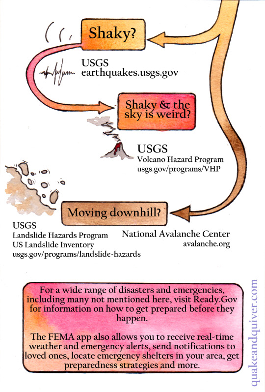
[image ID: a colorful infographic titled "Why is the..." with three branching paths - Water, Sky, Earth - and "so... :" Small relevant hand-drawn illustrations accompany each question. Links go to United States based resources addressing each weather concern.
Why is the sky so:
Hazy? AirNow.gov
Dark'n stormy? Weather.gov
Weird? NASA.gov
Why is the water so:
smelly/gross/weird? Mywaterway.epa.gov
Not where it's meant to be? See below.
Are you at the beach? (this branches off into many answers, all following water questions go from this one)
If yes, and Too little water where there should be? Tsunami.gov * if water at the beach dramatically recedes, run inland immediately
If no, and Too little water where there should be? Drought.gov
If yes, and Too much water where there shouldn't be? NOAA.gov; Digital coast*, Storm Prediction Center, National Hurricane Center. *Sea level rise viewer and coastal flood exposure mapper
If no, and Too much water where there shouldn't be? Ready.gov/floods, Weather.gov
Why is the earth so:
Shaky? USGS, earthquakes.usgs.gov
Shaky and the sky is weird? USGS, Volcano Hazard Program, usgs.gov/programs/VHP
Moving downhill? Usgs, Landslide Hazard Program, US Landslide Inventory, usgs.gov/programs/landslide-hazards; National Avalanche Center, avalanche.org
In a separate box at the bottom: For a wide range of disasters and emergencies, including many not mentioned here, visit Ready.gov for information on how to get prepared before they happen. The FEMA app also allows you to receive real-time weather and emergency alerts, send a notifications to loved ones, locate emergency shelters in your area, get prepared this strategies and more.
Quakeandqiver.com is credited in purple text along one side. End ID.]

Noticed something a little funky in the world around you and want to figure out what's up? Especially if there might be something you ought to be doing about it? Not sure what information sources to trust these days? If you're in the US, federal agencies like NOAA, USGS, EPA and more collect massive amounts of scientific data every day, much of which is publicly available online - if you know where to look.
A PDF version with clickable links is available for free on my itchio page (quakeandquiver); I'll add a direct link in a reblog.
33K notes
·
View notes
Text
Hurricanes potentially spread more than a hundred invasive species to Florida
Florida Phoenix – The Phoenix Flyer By: Mitch Perry – December 11, 2024 1:56 pm Recent hurricanes and associated flooding may have transported hundreds of nonnative species into Florida and Georgia, according to maps prepared by the U.S. Geological Survey (USGS). A preliminary map for Hurricane Helene indicates that 222 nonnative species “had the potential to spread due to storm-related flooding,…
0 notes
Text
Another earthquake before the Sixth Seal: Revelation 6
Another Earthquake Rattles New Jersey: USGS A small earthquake shook New Jersey again on Thursday, the U.S. Geological Survey confirmed. Posted Thu, Aug 8, 2024 at 2:07 pm ET Dozens of quakes have rattled the state since the 4.8 quake in April. (USGS) Another earthquake has struck New Jersey. (USGS) NORTH JERSEY, NJ — As Tropical Storm Debby targets the Garden State with possible flooding,…

View On WordPress
#america#Andrew the Prophet#andrewtheprophet#Earthquake#new jersey#new york#Quake#Sixth Seal#the prophecy#theprophecy
0 notes
Text

Coastal flooding (no storm), shallow groundwater exposure and erosion (unimpeded model case) for one meter of sea-level rise and observed vertical land motion (VLM) across the Southeast Atlantic coast.
Excerpt from this report from the US Geological Survey:
A study led by USGS outlines a multifaceted climate-driven crisis facing communities along the Southeast Atlantic coast of the United States. As sea level rises, increased flooding, land subsidence, beach erosion, and rising groundwater levels threaten the safety, property, and infrastructure of millions.
While previous research has largely focused on flooding, the new study highlights additional threats such as groundwater hazards, land subsidence, and beach erosion. These hazards, often underappreciated in climate discussions, will be amplified by sea levels projected to rise by one meter over the next century. The study estimates that up to 70% of coastal residents and $1 trillion in property could face challenges from shallow and emerging groundwater. This risk is 15 times greater than the exposure to daily tidal flooding alone.
Storm activity, which is becoming more intense with climate change, adds another layer of complexity. The study projects that storm-driven flooding over the next century, including storm surge and wave-driven water levels, could expose roughly 50% of coastal residents and $770 billion in property to severe flooding, an increase by an order of magnitude compared to daily flood impacts.
The study also warns of dramatic shoreline changes, with up to 80% of present-day beaches at risk of being completely eroded. This loss would not only devastate ecosystems and tourism but also weaken natural flood defenses, leaving coastal areas more vulnerable. Compounding these issues is the high rate of land subsidence already affecting more than one million residents in the region. This gradual sinking of the ground will intensify flooding and groundwater hazards, further challenging adaptation efforts.
3 notes
·
View notes