#Topographical Survey London
Text

How Topographical Surveys Enhance London’s Urban Planning
These surveys are fundamental tools utilized by urban planners, architects, engineers, and developers to comprehensively understand the landscape, its features, and the potential impact of proposed developments. We delve into the significance of Topographical Survey London enhancing the urban planning landscape.
0 notes
Text

Looking for topographical survey costs in London? Our professional services offer accurate assessments at competitive rates. Whether for construction, development, or land management projects, our surveys provide crucial insights into terrain and features. With meticulous attention to detail, we deliver comprehensive reports tailored to your specific needs.
0 notes
Text

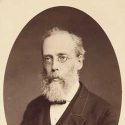


John Bartholomew was born in Edinburgh on December 25th, 1831 in Edinburgh.
If, like my family, you enjoyed playing Scrabble, I think the majority of us had at hand a Bartholomew's dictionary at hand for checking spellings and some of us had one of their atlas's where we could look up exotic places far from Scottish shores that we could only dream of, the world since then has gotten a hell of a lot smaller thanks to the World Wide Web and the Internet.
He was still very young when he acquired the skills of map drawing and engraving directly from his father, John Senior.
He was then sent to London for more formal training as a geographical draughtsman and engraver. He spent two years with the noted German geographer Augustus Petermann. His love for maps and geographical work soon led him to make rapid progress as a cartographer.
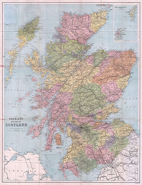
Returning to Edinburgh, he continued his father’s business with great energy, and, in conjunction with Dr Petermann, he contributed most of the maps to Fullarton’s Royal Illustrated Atlas, and to the Philip’s Imperial Atlas, drawn and engraved in Edinburgh. Other important works followed including Black’s General Atlas of the World; a large topographical map of Scotland on a scale of four miles to an inch; and afterwards a companion map of England and Wales from the survey just then completed.
In 1859, John married Annie, the daughter of John McGregor, a smith of Greenock. Following his first wife’s death in 1874 he married Anne Cumming, the daughter of Primrose Nimmo, a master brass founder of Edinburgh, and his wife, Anne Philip, who was related to George Philip, the founder of the Liverpool map makers.
From his two marriages, John had two sons, and seven daughters
John was sought after as an engraver in Scotland for work outside his cartographic focus as well, including as illustrated here botanical drawings.
He is said to have had a reserved nature, which made him unwilling to enter fully into public life, but he took great interest in the reformation of the Scottish rights of way and Recreational Society and was elected a fellow of the Royal Geographical Society in 1857.
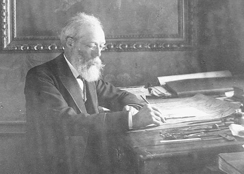
John travelled widely to obtain new work and introduced a programme of improvements, including the installation of lithographic printing, which brought considerable savings to the business from increased productivity.
His works attracted much public commendation, and received distinguished awards at different international exhibitions. About 1870, as the business gradually extended, several important atlases were undertaken for American and foreign publishers, the Handy General Atlas of the World being published simultaneously in England and America.
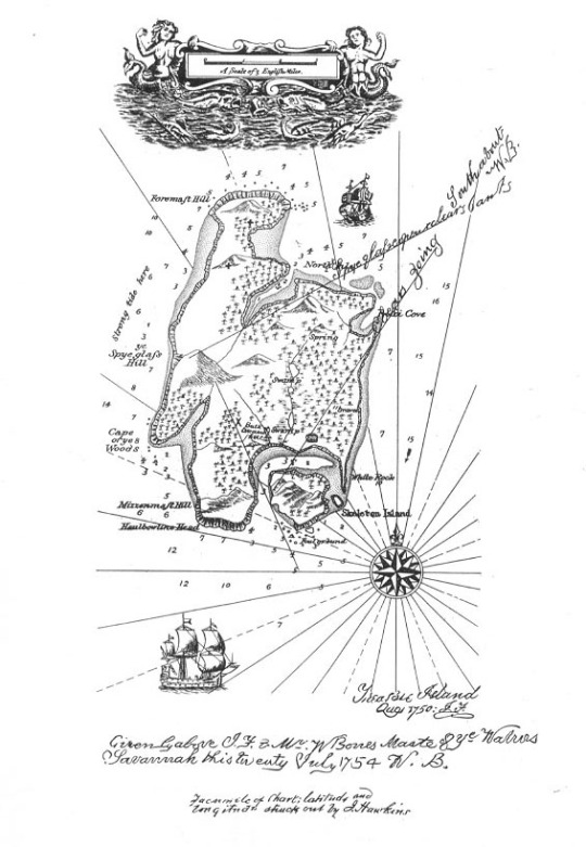
John Bartholomew Jr was also commissioned to engrave the map of Treasure Island for Robert L. Stevenson as seen in the pics
In 1888, he retired from active work, leaving the management of his business to his son, John George.
On a trip to London seeking special treatment, he died in March 1893 and was buried in Edinburgh.
12 notes
·
View notes
Text
Topographic Survey Penge
With assistance from a business like Topographic Survey London or one close by, land surveyors may evaluate a range of elements including the topography, soil conditions, and existence of any protected natural resources. Early identification of any compliance problems helps buyers and sellers to quickly rectify them and lower the risk of expensive consequences during the transaction process.
0 notes
Text

Cadmap Ltd is a specialised geospatial land & topographical surveying, measured building surveying and underground utility gpr, CCTV Drain surveying company based in London, Surrey, Brighton East Sussex, West Sussex, Southampton Hampshire and Guildford Surrey, fully accredited Land Surveyors & Measured Building surveyors, specialising in measured building surveyors in london, topographical surveys surrey, spot level surveys, site engineering site setting out, building movement monitoring surveys
0 notes
Text
Peja Surveying is your trusted partner in the UK, offering a comprehensive range of surveying services, including land, building, and topographical surveys. Our team of experts utilises the latest technology to deliver precise and reliable results, ensuring that your projects are completed with the highest level of accuracy and detail. Trust us to provide the insights you need for successful planning and development.
#Peja Surveying UK#land surveying services#building survey experts#topographical surveying#advanced survey technology#precise surveying results#UK surveying specialists#project planning accuracy#development survey insights
0 notes
Text
Topographic Surveys London
Castle Surveys Ltd
54 Poland St, London W1F 7NJ
020 3728 2884
0 notes
Text
Topographic Surveys London
Castle Surveys Ltd
54 Poland St, London W1F 7NJ
020 3728 2884
0 notes
Text
Topographic Surveys London
Castle Surveys Ltd
54 Poland St, London W1F 7NJ
020 3728 2884
0 notes
Text
Topographic Surveys London
Castle Surveys Ltd
54 Poland St, London W1F 7NJ
020 3728 2884
0 notes
Text
Topographic Surveys London
Castle Surveys Ltd
54 Poland St, London W1F 7NJ
020 3728 2884
0 notes
Text
Topographic Surveys London
Castle Surveys Ltd
54 Poland St, London W1F 7NJ
020 3728 2884
0 notes
Text

John Bartholomew was born in Edinburgh on December 25th, 1831 in Edinburgh.
If, like my family, you enjoyed playing Scrabble, I think the majority of us had at hand a Bartholomew's dictionary at hand for checking spellings and some of us had one of their atlas's where we could look up exotic places far from Scottish shores that we could only dream of, the world since then has gotten a hell of a lot smaller thanks to the World Wide Web and the Internet.
He was still very young when he acquired the skills of map drawing and engraving directly from his father, John Senior.
He was then sent to London for more formal training as a geographical draughtsman and engraver. He spent two years with the noted German geographer Augustus Petermann. His love for maps and geographical work soon led him to make rapid progress as a cartographer.
Returning to Edinburgh, he continued his father’s business with great energy, and, in conjunction with Dr Petermann, he contributed most of the maps to Fullarton’s Royal Illustrated Atlas, and to the Philip’s Imperial Atlas, drawn and engraved in Edinburgh. Other important works followed including Black’s General Atlas of the World; a large topographical map of Scotland on a scale of four miles to an inch; and afterwards a companion map of England and Wales from the survey just then completed.
In 1859, John married Annie, the daughter of John McGregor, a smith of Greenock. Following his first wife’s death in 1874 he married Anne Cumming, the daughter of Primrose Nimmo, a master brass founder of Edinburgh, and his wife, Anne Philip, who was related to George Philip, the founder of the Liverpool map makers.
From his two marriages, John had two sons, and seven daughters
John was sought after as an engraver in Scotland for work outside his cartographic focus as well, including as illustrated here botanical drawings.
He is said to have had a reserved nature, which made him unwilling to enter fully into public life, but he took great interest in the reformation of the Scottish rights of way and Recreational Society and was elected a fellow of the Royal Geographical Society in 1857.
John travelled widely to obtain new work and introduced a programme of improvements, including the installation of lithographic printing, which brought considerable savings to the business from increased productivity.
His works attracted much public commendation, and received distinguished awards at different international exhibitions. About 1870, as the business gradually extended, several important atlases were undertaken for American and foreign publishers, the Handy General Atlas of the World being published simultaneously in England and America.
John Bartholomew Jr was also commissioned to engrave the map of Treasure Island for Robert L. Stevenson as seen in the pics
In 1888, he retired from active work, leaving the management of his business to his son, John George.
On a trip to London seeking special treatment, he died in March 1893 and was buried in Edinburgh.
9 notes
·
View notes
Text
Topographic Surveys London
Castle Surveys Ltd
54 Poland St, London W1F 7NJ
020 3728 2884
0 notes
Text
Topographic Surveys London
Castle Surveys Ltd
54 Poland St, London W1F 7NJ
020 3728 2884
0 notes
Text
Topographic Surveys London
Castle Surveys Ltd
54 Poland St, London W1F 7NJ
020 3728 2884
0 notes
Last Seen Blogs

thislilfecker
thislilfecker

thousands-slowly-dying-sunsets
Πανωραία-Αικατερίνη🌌

picrewfarm
How to Soothe Bored Hands

allfuzzyinside-blog
All Fuzzy Inside

fate-sealer
Everybodies Favorite Horseman Ambarnon