#The Richat Structure - Mauritania
Explore tagged Tumblr posts
Text
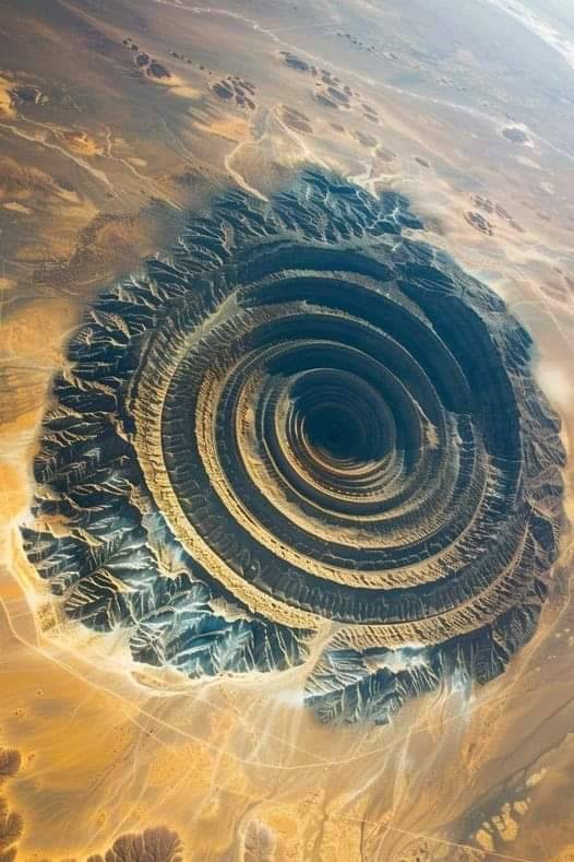
Richat Structure (Guelb er Richât) - MAURITANIA
148 notes
·
View notes
Text
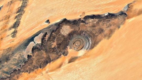
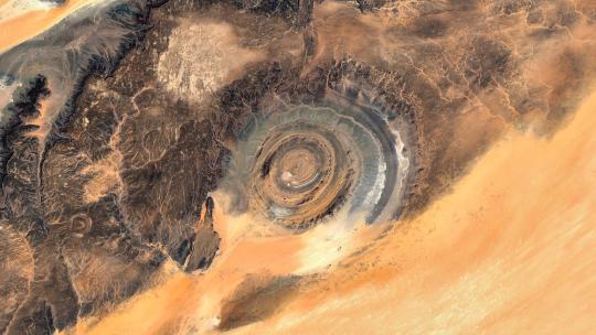
Richat Structure (Guelb er Richât) - Mauritania 🌍 4K link
#mauritania#richat#guelb er richat#structure#eye of the desert#google earth#wallpaper#aerial photography#satellite view#4k#abstract#atlas#texture#desert#relief#earth art#earth from above#earth from space#dji#landscape
42 notes
·
View notes
Video
youtube
To be completed in longer episodes as the story unfolds...
#youtube#atlantis stories#archaeology#plato’s atlantis#Plato’s Timaeus#Plato’s Critias#atlantis the lost empire#richat structure#richat atlantis#richat structure mauritania
0 notes
Text
First image looked too artificial.
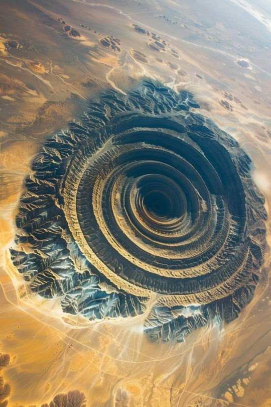
The Richat Structure, also known as "The Eye of the Sahara". Located in Mauritania, the structure is about 50 km in diameter. It was initially thought to be the result of an impact event because large meteors typically produce circular features on Earth's surface. But geologic studies have revealed that it is actually an uplifted geologic dome, also known as a domed anticline.
821 notes
·
View notes
Text
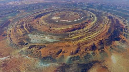
The Richat Structure, also known as "The Eye of the Sahara".
Located in Mauritania, the structure is about 50 km in diameter. It was initially thought to be the result of an impact event because large meteors typically produce circular features on Earth's surface. But geologic studies have revealed that it is actually an uplifted geologic dome, also known as a domed anticline.
The original posted image was AI. I removed it. I was misinformed. The correct image is below. Thanks for the correction.
1K notes
·
View notes
Text
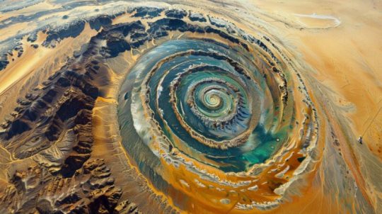

"The Eye of the Sahara, also known as the Richat Structure, is a striking geological formation located in the Sahara Desert in Mauritania. This massive, circular feature is approximately 50 kilometers in diameter and can be easily seen from space, resembling a giant eye. Known for its concentric rings of rock, this geological wonder has puzzled scientists and inspired myths for years."
690 notes
·
View notes
Text
i learned what are the most mysterious places in the world
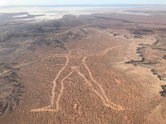
Marree Man – The fact that there is not a single witness to the creation of the Marree Man speaks to the absolute isolation of central South Australia. Somehow in 1998, one person or a group of people were able to create a 2.6-mile long line drawing of an aboriginal hunter, without being seen. In the midst of barren, arid land in South Australia, the Marree Man is the largest geoglyph and work of art in the world. Cut into the harsh landscape with lines over 115 feet wide and one foot deep, the towering Marree Man is easily visible from space. Thirteen years after the Marree Man was discovered during a flyover, little is known about its origin. Although we may never know the true origin of the Marree Man, it is certainly one of most intriguing modern day mysteries.
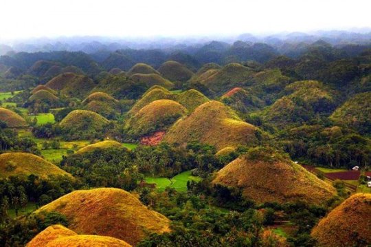
Chocolate Hills – Bohol Island in the Philippines during the dry season, you might notice what looks like thousands of chocolate kisses protruding from the terrain. These mysterious conical mounds are known as the Chocolate Hills. There are approximately 1,268 individual hills, their heights ranging from 100 to 160 feet, though the highest is almost 400 feet high. The hills, which are almost all symmetrical, consist of grass-covered limestone and turn brown during the dry season. Despite the abundance of hills, it is unclear how they were formed. There are multiple geological explanations ranging from oceanic volcano activity to limestone weathering. Numerous legends and tales also exist to explain the Chocolate Hills.
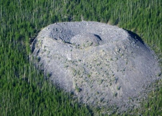
Giants Nest – In 1949 a geologist named Vadim Kolpakov discovered a large mound of limestone in the north of the Irkutsk region in southeastern Siberia. The cone is curiously shaped with a crater at the top and a small mound in the center. The mound is about 40 meters high and 100 meters across at the base. The smaller mound at the top is about 12 meters high. The crater was named Patomskiy, after a nearby river, but local residents call it “the Fiery Eagle’s Nest”. Since the discovery of the crater, there have been many theories as to what could have created it. For a long time it was believed to be a meteorite impact structure. Some linked it to the Tunguska meteorite, whose remains have never been discovered. But the crater does not resemble any other known meteorite site. Even now, the origin of the crater is not discovered.
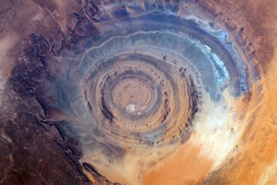
Richat Structure – In the midst of vast, vacant Sahara desert, just outside of Ouadane, Mauritania, lies a 30-mile wide geological oddity known the Richat Structure, sometimes called the “Eye of Africa.” From space, this natural curiosity forms a distinct and unmistakable bull’s-eye that once served as a geographical landmark for early astronauts as they passed over the Sahara. Once thought to be an impact crater due to its circularity, the unusual formation is now widely believed to have been caused by the erosion of a geological dome formed by pressure from a bulb of molten magma below.
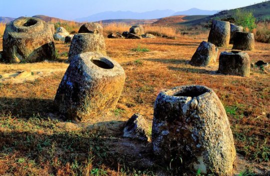
Plain of Jars – The Plain of Jars is a collection of large stone jars interspersed throughout the Xieng Khouang plain in the Lao Highlands. The stone structures are mostly made of sedimentary rock and, ranging from 3 to 10 feet in height, each can weigh up to 14 tons. To date, the origin of the jars is unknown, though archaeologists believe that they were originally used between 1,500 and 2,000 years ago. Many researchers have theorized that the jars may have once served as funerals urns or food storage. As local Laotian legend would have it, the jars were created by Khun Cheung, an ancient king of giants who lived in the highlands. It is said that Cheung, after fighting a long and victorious battle, created the jars in order to brew huge amounts of celebratory lao lao rice wine.
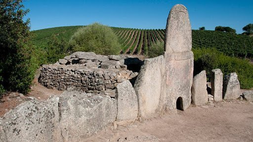
Giant’s Grave of Coddu Vecchiu – Giant’s or Tomba Dei giganti, are megalithic gallery graves that were used as public tombs during the Bronze Age. The massive gravestones were built by the Nuragic civilization, which existed in Sardinia from the 2nd millennium BCE. to the 2nd century CE. Despite the imaginative name, the sites were not the burial site of any giant; they were giant community burial chambers. Though we know the tombs had a funerary purpose, more questions remain. Little is known about the rituals or traditional beliefs that motivated their construction. Were they mass graves? Were they built to facilitate the journey into the afterlife? Since their existence has yet to be justified by scientific research, they have been credited to the supernatural, which has only increased their mystery. Legend also claims that yes, indeed, these were the tombs of powerful giants.
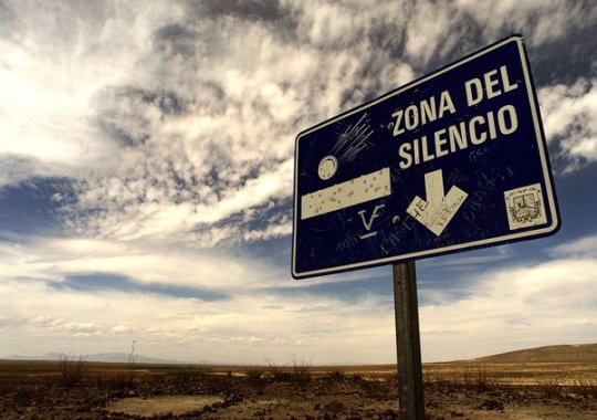
Zone of Silence – Pilot Francisco Sarabia was flying over a patch of desert land in Mexico when his instruments started to act increasingly odd. The man had to make an emergency landing in the middle of nowhere. Little did he know that this "nowhere" would be later dubbed "The Zone of Silence.” Weird radio silence isn't the only oddity of the creepy Zone. Like, what’s that weird trio that locals keep meeting in the Zone? They’re two men and a woman. Every time people see them, they’re wearing bizarre clothing that isn't suitable for a journey in the desert whatsoever. On top of all that, the Zone of Silence is known as a 50 km patch of deserted land where meteorites come crashing down on an eerily regular basis. On July 11, 1970, the US launched an ATHENA rocket from the Air Force base in Green River, Utah. The rocket was supposed to land somewhere in the area of White Sands in New Mexico. Instead, it went off course and, as if being pulled by some external force, crashed right in the heart of the Zone of Silence.
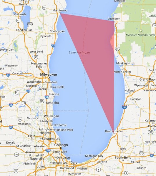
Michigan Triangle – Stretching from Ludington to Benton Harbor, Michigan and to Manitowoc, Wisconsin, the Lake Michigan Triangle has inspired numerous accounts of activity that are difficult to explain by rational thought. The mystery began in 1891, when a schooner named the Thomas Hume set off across the Lake to pick up lumber. Almost overnight in a torrent of wind, the Thomas Hume disappeared along with its crew of seven sailors. The wooden boat was never found. After the turn of the century, strange events happened at steady intervals. Of the more mysterious is the case of the Rosa Belle. In 1921 eleven people inside the ship, who were all members of the Benton Harbor House of David, disappeared and their ship was found overturned and floating in Lake Michigan. While it appeared that the ship had been damaged in a collision, no other ship had reported an accident and no other remains had been found.
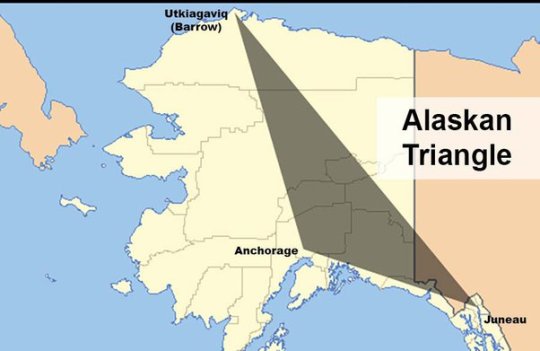
Alaska Triangle – The Alaska Triangle is a place in the untouched wilderness where mystery lingers and people go missing at a very high rate. The area began attracting public attention in October 1972, when a small, private plane carrying U.S. House Majority Leader Hale Boggs, Alaska Congressman Nick Begich seemingly vanished into thin air. For more than a month, 50 civilian planes and 40 military aircraft plus dozens of boats, covered a search area of 32,000 square miles, but no trace of the plane, the men, wreckage or debris were ever found. Afterward, more planes went down, hikers went missing, and Alaskan residents and tourists seemed to vanish into thin air. In fact, since 1988, more than 16,000 people have disappeared in the Alaska Triangle, with a missing person rate at more than twice the national average. These disappearances are blamed on everything from severe weather to aliens, to swirling energy vortexes, to an evil shape-shifting demon of Tlingit Indian lore called Kushtaka, with no scientific explanation to the disappearances till today.
The Initiation Well – The Initiation well is 88 feet deep well located on the land of Quinta da Regaleira. Actually, it was used for ceremonial purposes. There is another small well near this well. Both these wells are connected by tunnels. The larger well contains a 27-meter spiral staircase with several small landings and the smaller well contains straight stairs that connect a series of ring-shaped floors to one another. The smaller well is also called the 'Unfinished Well'. The depth of this larger well is equal to the four-storey building, which becomes narrower on going closer to the ground. It is believed that there is some kind of light comes out from the well inside the ground and comes outwards. Surprisingly, there is no system of light inside this well, then where from this light comes, it is the secret. Anyone who comes to visit here, always raises the question of where the light comes from inside the well? Till today this secret is unsolved.
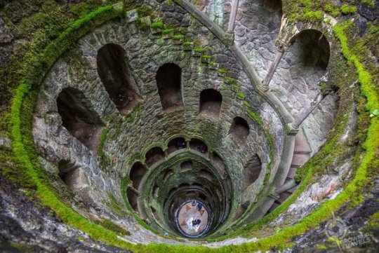
(Image Source : Google)
Thanks for Reading.
694 notes
·
View notes
Text
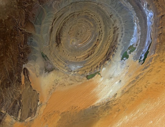
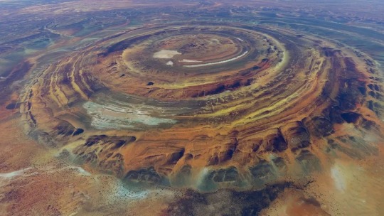
The Richat Structure in the Saharan Desert of Mauritania.
An eroded geologic dome.
95 notes
·
View notes
Text
A 100 million years old city?!
At the western edge of the Sahara desert, in today’s country of Mauritania, there is an object that is so strange that every time scientists try to explain it, they cannot find any reasonable arguments and sound ridiculous. The so-called Eye of the Sahara, or Richat Structure, is apparently an extremely ancient city, built of rock massifs in concentric shapes, just as Plato described Atlantis.…

View On WordPress
#ancientmysteries#firstcity#oldestcity#richat#richateye#richatstructure#dimitaralekseevdimitrov#history
7 notes
·
View notes
Text
The Eye of the Sahara, also known as the Richat Structure, is a prominent geological wonder in the Adrar Plateau of the Sahara Desert, Mauritania. It's not an impact crater, as once believed, but rather an eroded dome with concentric rings. Read more here:
20 notes
·
View notes
Text

The Richat Structure, also known as "The Eye of the Sahara".
Located in Mauritania, the structure is about 50 km in diameter. It was initially thought to be the result of an impact event because large meteors typically produce circular features on Earth's surface. But geologic studies have revealed that it is actually an uplifted geologic dome, also known as a domed anticline.
There is no way this was a geological accident. This was created by intelligent agents of some species yet unknown.
8 notes
·
View notes
Text

On October 7, 2023, the Moderate Resolution Imaging Spectroradiometer (MODIS) on NASA’s Terra satellite acquired a true-color image of “The Eye of the Sahara”.
Although it looks like it could be an impact crater, it actually formed when a volcanic dome hardened and then gradually eroded, slowly exposing the ringed rock layers. The result is an onion-like formation, with ridges formed of weather-resistant rocks while less-resistant rock forms valleys between the ridges. Some of the igneous rocks found within the structure have been dated as having cooled between 94 and 104 million years ago.
Richat Structure in Mauritania
14 notes
·
View notes
Text

The Richat Structure, also known as “The Eye of the Sahara”.
Located in Mauritania, the structure is about 50 km in diameter. It was initially thought to be the result of an impact event because large meteors typically produce circular features on Earth’s surface. But geologic studies have revealed that it is actually an uplifted geologic dome, also known as a domed anticline.
0 notes
Text
Best tours in mauritania,
Best tours in mauritania,
Mauritania, a hidden gem in Northwest Africa, offers a unique blend of Saharan adventure, ancient history, and cultural richness. Whether you're a seasoned traveler or a curious explorer, Mauritania's diverse landscapes and vibrant heritage promise an unforgettable experience. Here are some of the best tours to consider when visiting this fascinating country:
Nouakchott City Tour Nouakchott, the capital city, is a great starting point for any Mauritania tour. This bustling metropolis offers a mix of modernity and tradition. Key highlights include:
Port de Pêche: Witness the colorful fishing boats and the daily catch, providing a glimpse into the local fishing industry. National Museum of Mauritania: Explore artifacts and exhibits that showcase the rich history and culture of the region. Nouakchott Grand Mosque: Marvel at the architecture of one of the largest mosques in the country.
Adrar Plateau and the Ancient City of Chinguetti The Adrar Plateau is home to dramatic desert landscapes and historical sites. A tour here often includes:
Chinguetti: Known as the "Library of the Desert," this ancient city is a UNESCO World Heritage site and one of Islam's seven holy cities. Its medieval libraries house thousands of ancient manuscripts. Terjit Oasis: A serene oasis nestled within the desert, offering a cool respite with its palm groves and natural springs. Ouadane: Another UNESCO site, this ancient caravan town is known for its ruins and historical significance.
Banc d'Arguin National Park For nature enthusiasts, Banc d'Arguin National Park is a must-visit. This UNESCO World Heritage site is one of the world's most important bird-watching areas. Highlights include:
Bird Watching: Spot a variety of migratory birds, including flamingos, pelicans, and terns. Traditional Fishing Villages: Experience the lifestyle of the Imraguen people, who have been fishing sustainably for centuries. Diverse Marine Life: The park's coastal waters are home to dolphins, sea turtles, and various fish species.
The Sahara Desert Experience No trip to Mauritania is complete without a Sahara Desert adventure. Tours typically include:
Camel Treks: Explore the vast dunes on camelback, an iconic desert experience. Desert Camping: Spend the night under the stars in a traditional Mauritanian tent, enjoying local cuisine and storytelling. Richat Structure (Eye of the Sahara): Visit this unique geological formation, often referred to as the "Eye of Africa," for its striking circular appearance.
The Iron Ore Train Journey For the truly adventurous, the Iron Ore Train offers a unique and rugged travel experience:
Longest Train in the World: Ride atop one of the longest trains in the world, which transports iron ore from the mines in Zouérat to the port city of Nouadhibou. Scenic Views: Enjoy breathtaking views of the desert landscape along the way. Cultural Interaction: Meet locals and fellow travelers, sharing stories and experiences.
Nouadhibou and Cap Blanc Nouadhibou, the second-largest city, and Cap Blanc peninsula offer coastal beauty and history:
Shipwrecks: Explore the eerie and fascinating shipwrecks that dot the coastline. Cap Blanc Nature Reserve: Visit the colony of Mediterranean monk seals, one of the world's most endangered seal species. Port de l'Amitié: Stroll along the bustling port and enjoy fresh seafood at local markets. Tips for Travelers Travel Permits: Some areas require travel permits, so plan ahead and ensure all necessary documents are in order. Local Guides: Hiring local guides can enhance your experience with their knowledge and insights into Mauritania's culture and history. Cultural Sensitivity: Respect local customs and traditions, particularly in more conservative areas. Conclusion Mauritania's tours offer a blend of adventure, history, and natural beauty that is sure to captivate any traveler. From the bustling streets of Nouakchott to the serene deserts and ancient cities, there's something for everyone in this unique and often overlooked destination. Whether you're exploring the sands of the Sahara or the shores of Banc d'Arguin, Mauritania promises an unforgettable journey.
0 notes
Text
Best tours in mauritania,
Best tours in mauritania,
Mauritania, a captivating country in West Africa, is often overlooked by travelers but offers an array of unique experiences that make it a gem for adventurers. From the vast expanses of the Sahara Desert to the rich history embedded in ancient cities, Mauritania presents a tapestry of landscapes and cultures waiting to be explored. Here are some of the best tours to consider when visiting this fascinating country.
Nouakchott City Tour The bustling capital city, Nouakchott, is the perfect starting point for any Mauritanian adventure. A city tour typically includes visits to:
Port de Pêche: The vibrant fishing port where you can watch traditional fishing boats bring in their catch and experience the lively fish market. National Museum of Mauritania: A glimpse into the country’s history, showcasing artifacts from prehistoric times to the present. Nouakchott Mosque: One of the largest and most beautiful mosques in the city, reflecting Islamic architecture.
Banc d'Arguin National Park A UNESCO World Heritage site, Banc d'Arguin National Park is a paradise for bird watchers and nature enthusiasts. Tours here offer:
Bird Watching: The park is home to millions of migratory birds, including flamingos, pelicans, and terns. Imraguen Fishing Villages: Experience the traditional lifestyle of the Imraguen people, who have fished these waters for centuries.
Chinguetti and Ouadane Explore the ancient caravan towns of Chinguetti and Ouadane, which are vital stops on the Saharan trade routes.
Chinguetti: Known as the "City of Libraries," Chinguetti boasts ancient manuscripts and a stunning mosque that dates back to the 13th century. Ouadane: Visit the ruins of this once-thriving trade center and enjoy panoramic views of the Sahara from the old city's fortifications.
Adrar Plateau and Atar The Adrar region offers breathtaking landscapes and historical sites.
Atar: This town serves as a gateway to the Adrar plateau. From here, you can visit the rock formations at Amogjar Pass and the oasis town of Azougui, an ancient capital of the Almoravid dynasty. Richat Structure: Also known as the "Eye of the Sahara," this geological formation is visible from space and provides a unique trekking experience.
Terjit Oasis A short drive from Atar, Terjit is a picturesque oasis nestled in a canyon, offering:
Natural Springs: Relax in the cool waters of the oasis’s natural springs, surrounded by palm trees and dramatic cliffs. Camping: Spend a night under the stars in a traditional Mauritanian tent, enjoying the tranquility of the desert.
Train Journey on the Iron Ore Train For the adventurous, riding the Iron Ore Train from Zouerat to Nouadhibou is an unforgettable experience. Known as one of the longest and heaviest trains in the world, this journey offers:
Spectacular Desert Views: The train traverses the heart of the Sahara, providing stunning and starkly beautiful desert vistas. Cultural Insight: Meet locals and fellow travelers, and experience the rugged conditions of this unique mode of transport.
Tidjikja and Tagant Plateau The Tagant region, with its dramatic plateaus and historic towns, is perfect for those seeking to explore off-the-beaten-path destinations.
Tidjikja: This charming town is known for its traditional Saharan architecture and serves as a base for exploring the Tagant Plateau. Ksar El Barka: Visit the ruins of this ancient fortified village, offering a glimpse into the history of the region.
Nouadhibou and the Bay of Nouadhibou The coastal city of Nouadhibou offers maritime adventures and historical exploration.
Cape Blanc: Visit the seal colony and enjoy views from this scenic cape. Shipwrecks: The bay is known for its eerie ship graveyard, where rusting vessels create a unique and haunting landscape. Practical Tips for Touring Mauritania Travel Season: The best time to visit is from November to February when temperatures are cooler. Local Guides: Hiring local guides is recommended for navigating the desert and understanding the historical contexts. Cultural Respect: Mauritania is a Muslim country, so modest clothing and respect for local customs are important. Mauritania offers a rich and varied tapestry of experiences, from historical cities and vibrant cultures to the stunning and remote landscapes of the Sahara. Whether you're seeking adventure, tranquility, or cultural immersion, the tours in Mauritania promise an unforgettable journey.
0 notes
Text
Answer to What is the origin of the Richat Structure in Mauritania, known as the Eye of the Sahara? by Davide Fiore https://fantasticfossils.quora.com/What-is-the-origin-of-the-Richat-Structure-in-Mauritania-known-as-the-Eye-of-the-Sahara-1?ch=18&oid=1477743731363484&share=88ab60b5&srid=7KVRc&target_type=answer
0 notes