#Shafer Trail Viewpoint
Explore tagged Tumblr posts
Photo

Not the Grand Canyon
What do you think about my pic?
#Shafer Trail Viewpoint#Canyonlands National Park#Utah#desert#cliff#red rock#rock formation#Colorado Plateau#landscape#countrside#travel#Island in the Sky#truffles#grass#bush#original photography#summer 2022#tourist attraction#landmark#blue sky#clouds#photo of the day#What do you think about my pic?#light and shadow
3 notes
·
View notes
Video
youtube
Overlooks - Island in the Sky - Canyonlands National Park - Utah
Island in the Sky, située dans le Parc National de Canyonlands en Utah, est une mesa large et plate située au sommet de falaises de grès abruptes qui s'élèvent à plus de 300 mètres au-dessus du terrain environnant.
Chaque point de vue offre une perspective différente sur le paysage étonnant de ce magnifique parc.
Shafer Canyon Overlooks 38.45982, -109.81996 Overlook 1 38.45270, -109.81811 Overlook 2
Ces deux belvédères sont érigés au bord de la mesa et nous permettent d'admirer le Shafer Canyon. La Shafer Trail, une route en lacet, descend dans ce canyon situé à 426 mètres en contrebas.
The Neck 38.45109, -109.82076
On voit la route qui traverse une étroite bande de terre connue sous le nom de « The Neck ». Ce petit pont de pierre est tout ce qui relie Island in the Sky au reste de la terre.
Shafer Trail Viewpoint 38.44825, -109.82151
Ce belvédère offre une superbe vue sur la Shafer Trail qui serpente dans les parois vertigineuses de la falaise pour se rendre dans le canyon situé en contrebas.
Mesa Arch Overlook 38.38920, -109.86811 Stationnement 38.38804, -109.86349 Mesa Arch
Mesa Arch Trail est une très jolie arche qui surplombe Buck Canyon. Cependant, il faut entreprendre une randonnée facile de 1,1 km en boucle pour l'admirer (https://youtu.be/H0WbNoav3xA).
Green River Overlook 38.37931, -109.88805 Stationnement 38.37833, -109.88833 Belvédère
Le Green River Overlook est un belvédère où l'on peut voir la Green River serpenter à travers le vaste bassin de Soda Springs.
Aztec Butte Trail 38.39347, -109.88205 Début du sentier 38.39529, -109.87987 Grenier 38.39730, -109.87471 Aztec Butte
Ce sentier modéré de 2,7 kilomètres aller/retour nous permet de découvrir un ancien grenier Anasazi d'où l'on bénéficie d'une vue sensationnelle sur Taylor Canyon ainsi qu'Aztec Butte au haut de laquelle un sentier en boucle offre de superbes points de vue sur le canyon, les nombreuses formations rocheuses ainsi que sur les montagnes La Sal (https://youtu.be/mVcU4VLAfBY).
Holeman Spring Canyon Overlook 38.41211, -109.90469
Un sentier de +/- 800 mètres aller retour qui mène à superbe point de vue sur le canyon. Nous devons stationner notre véhicule en bordure de la route pour entreprendre cette randonnée.
Alcove Spring 38.42309, -109.90878 Début du sentier 38.42372, -109.90742 Point de vue
Nous n'avons parcouru qu'une centaine de mètres sur ce sentier difficile de 18 km pour obtenir un joli point de vue sur le canyon.
Whale Rock Overlook 38.42677, -109.91400 Début du sentier 38.42831, -109.91695 Fin du sentier
Ce belvédère n'est accessible que par un sentier de randonnée de 1,3 km aller-retour qui monte sur un dôme de grès qui offre une vue à 360° sur Island in the Sky (https://youtu.be/idfKXmZgrVM).
Upheaval Dome Overlooks 38.42631, -109.92609 Début du sentier 38.42900, -109.92920 Point de vue 1 38.42972, -109.93376 Point de vue 2 et fin du sentier
Upheaval Dome Trail est un sentier modéré de 2 km aller-retour qui offre de jolis points de vue sur une formation géologique en forme de cratère dont le diamètre intérieur est de +/- 5 km et qui est situé à plus de 300 mètres de profondeur (https://youtu.be/las6uxMoUnA).
Candlestick Tower Overlook 38.37444, -109.86848
Ce belvédère offre une vue magnifique sur le parc, et plus particulièrement, sur une formation rocheuse appelée Candlestick Tower, une butte de grès de 140 mètres de hauteur.
Buck Canyon Overlook 38.34580, -109.86097 Stationnement 38.34596, -109.86021 Belvédère
Il ne s'agit que d'une promenade de 140 mètres aller-retour pour admirer une vue imprenable sur le canyon avec les montagnes de La Sal au loin.
White Rim Overlook 38.32277, -109.84951 Début du sentier 38.31995, -109.83524 Belvédère
L'une des meilleures vues orientées vers l'Est est certainement White Rim Overlook. Ce belvédère est accessible par un sentier facile de 2,9 km aller-retour qui offre une vue panoramique sensationnelle sur le fleuve Colorado, Monument Basin et les montagnes de La Sal (https://youtu.be/2YwE8vkZR5Y).
Orange Cliffs Overlook 38.31365, -109.85700
Ce belvédère offre une vue panoramique sur le canyon de Green River. On aperçoit les falaises de grès appelées Orange Cliffs qui sont situées dans le Glen Canyon ainsi que le secteur The Maze de Canyonlands qui s'étend vers le Sud.
Grand View Point Overlook Trail 38.31077, -109.85657 Début du sentier 38.31019, -109.85672 Belvédère 1 38.30333, -109.86781 Belvédère 2
Grand View Point Overlook Trail est un sentier de 3 kilomètres aller-retour qui offre des points de vue sur un réseau complexe de canyons creusés par la convergence du fleuve Colorado et de la rivière Green (https://youtu.be/8cwcOpRJhE0).
AUTRES VIDÉOS: https://www.youtube.com/playlist?list=PLlRroQCNvchsdvRQOTUATm7OU6BabhYIF
ABONNEZ-VOUS ►https://www.youtube.com/c/SouthAngelVideo?sub_confirmation=1
SUIVEZ NOUS: • BLOGGER ►http://southangelvideo.blogspot.ca/
0 notes
Photo

Shafer Trail Viewpoint, UT - 3696 × 2464 [OC]. Canyonlands National Park. via /r/EarthPorn https://ift.tt/3m4rgza
0 notes
Photo
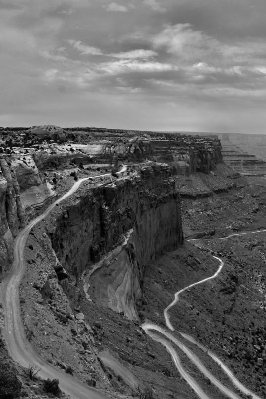
Shafer Trail Viewpoint, Canyonlands National Park, Moab, UT
0 notes
Text
Moab (Utah) to Yuma (Arizona) - 10-20 Nov 2017
We were planning to use Moab as a base for exploring the nearby National Parks - Arches and Canyonlands. We thought the town would have a bit of the "cool" factor, a bit like Bend in Oregon, but it wasn't quite like that. It was a functional base for exploring the surrounding areas - i.e. not that much in the town itself. It didn't matter, we were happy.
The morning after arriving in Moab, we set off for Canyonlands National Park. It was perfect riding weather.


Although we were several hundred kilometres distant from the Grand Canyon in Arizona, Canyonlands is effectively an extension of the same canyon in a different state. The views were absolutely huge. In fact it was hard to comprehend that the far rim of the canyon was often 10km distant from where we were standing.


Whilst on the rim of the canyon, we noticed a dirt road snaking down precipitously from the lip into the abyss below. Further enquiry revealed that this was an old miners' track, called the Schafer Trail. We decided to return the following day to see if we could ride the Schafer Trail.


Beautiful place!


The views were spectacular!


We rode on to get to as many viewpoints as possible 😊


We walked up to a beautiful natural archway and some incredible views!


Gorgeous!!


This is definitely a million dollar view! 😍😍


We were definitely in the desert - the landscape was fantastic!!


We got back on our bikes and rode on.

The views were just amazing!


Canyonlands National Park is definitely out-of-this-world-beautiful! We loved being there!! 😍


We rode on - everywhere was so beautiful!


As was the case in Bryce Canyon and Zion, we met lots of lovely and friendly folks who were intrigued by our foreign number plates and stories of our trip. We were enjoying the national parks of Utah very much.

The light was going so it was time to head back. Oh the gorgeous roads! 😊


We got back to Moab starving. The most immediate dinner option was in the diner 😉


We left Moab early the next morning to head back towards Canyonlands.


We rode past an area famous for petroglyphs.

Apparently there were many......

But you really had to look closely! 😉

By following the banks of the Colorado river, we were able to ride into the bottom of the canyon but not before stopping by a beautiful edge of the river. The landscape was great!


We hoped to ride the Shafer Trail from the bottom of the canyon, upwards to the rim. The trail started easy....


We were about 10kms into the trail, when it became obvious that it was unacceptably difficult for our riding skills (incredibly loose gravel and patches of powdery dust, huge rocks, steep uphills with no obvious grippy surface for our bikes to stay upright). Combined with the fact that an experienced motorcyclist died whilst riding this trail a month previously, we decided to turn back.... but not before taking some fabulous photos from the base of the canyon.


As it was early in the day we decided to ride to Arches National Park. Arches was physically smaller than Canyonlands and much closer to Moab, so it was an easier riding day. Yet again the views were wonderful! 😍


We got back to Moab and James found us a lovely little Thai restaurant for dinner. Thai food makes us very happy! 😁

After a couple of days of great riding around Moab, it was time to leave. Winter was coming and whilst the days were still warm, the nights were becoming very cold. And we still had to ride to the Grand Canyon (problems, problems!😋) which was also likely to be cold. We set off the next morning for the 2 day return trip to Page, Arizona, from where we would ride south to the Grand Canyon.
Day 1 was the backtrack to Blanding, Utah. On the way, we decided to do the 55km diversion to the east rim of the canyon of which we had seen so much in Canyonlands.


The diversion was well worthwhile as we didn't see one other traveller all day. We had the entire rim of the canyon to ourselves!!


The views were AMAZING! 😍


We couldn't believe we were the only people there! Such a beautiful place 😊


We enjoyed the peace and quiet. The views were incredible and it felt quite surreal that the place wasn't swarmed with tourists. We felt very lucky! 😊


It was amazing just being there and admiring the sheer beauty of the canyon. We stayed there for ages 😊


Reluctantly after about an hour and a half we had to keep going. We loved our surprisingly incredible stop though 😍

The remaining ride to Blanding was very enjoyable.


There was one last treat in store for us - we saw a beautiful wild antelope along the way 😊

We reached our comfy motel in Blanding in daylight and recreated the same dinner as on the trip north - a Subway sandwich plus instant noodle soup. There still wasn't much in Blanding!! 😉
Day 2 of our return ride to Page, Arizona gave us the chance to ride the Valley of the Gods, the 40km offroad loop that we had seen on the trip north. We loved the Valley and its stunning views. It was in places like this that the adventure bikes really came into their own. We could go places that normal cars simply could not.


After a great morning in Valley of the Gods, we then re-rode through Monument Valley before arriving in Page. A really great day of riding!


This time we merely overnighted in Page before heading out the following morning for the long, cold ride to the Grand Canyon.

We largely rode through desert all day, but the low temperature told us it was time to head south for Winter. After the Grand Canyon, we would head towards Mexico.


We arrived at the Grand Canyon National Park at 3pm in the afternoon.

There's something really cool about arriving in such a place on our fully loaded bikes!! 😁


Wow!

Amazing views!!


The final 30km of the day's ride was along the rim of the canyon. We had our first views .... and photos. Stupendous views 😍😍


Bikes parked on the edge of the Grand Canyon! 👍😀


We loved being able to ride around the Grand Canyon!


Wonderful views! 😍


Whilst admiring the views, we met a lovely couple Geralene and Randy. It was a pleasure to meet you guys!! 😊👋


After the sun set, it got really cold! It was time to get to our hotel (but not before the last photo of course) 😉

It was 6pm, freezing and dark by time we reached our hotel in Tusayan, a few miles away from the Canyon Village ....... not before all the traffic stopped for a herd of wild elk. Lovely!
Tusayan is a very expensive place to stay, but once again Anna had performed her magic by getting us a lovely room in the best hotel in town for an unbelievably cheap price! The woman knows how to find a bargain! �� We planned to stay 2 nights giving us the next day to further explore the Canyon.


As private vehicles are not permitted in most of the National Park, we spent most of the following day hopping on and off shuttle buses along the south rim of the Canyon.


It was a beautiful day and we were lucky enough to get some lovely photos.


The views were truly grand! 😍


The hiking trails looked interesting.


The Grand Canyon is so beautiful! 😍


All the layers and colours looked spectacular in the beautiful sunshine 😊


Gorgeous place!


We had the most amazing day at the Grand Canyon. Incredible place! 😍

It was getting cold so it was time to hop on our bikes and ride to our hotel.

Ten minutes down the road we saw an elk. Nice end to a beautiful day 😊


We got back to our hotel in darkness and since prices in nearby restaurants were utterly ridiculous, we enjoyed supper of ham, cream cheese and crackers and spicy instant noodle soup in our room. Yummy!

We left our lovely Tusayan hotel the next morning for the long 2 day ride to Yuma, Arizona, close to the Mexican border. This would be our final stop in the US before entering Mexico. Our overnight stop was in the small town of Wickenburg, Arizona which turned out to be a sweet little town.


The pool looked inviting so we decided to stay an extra night 😉

The weather in the morning was lovely. We went for a walk around town.


Then it was time for some mechanicing......

Before relaxing in the pool and the hot tub! 😁


We had an early night and wondered over to Denny's where our motel provided breakfast. For once we had an amazingly sinful brekkie 😋


Our ride to Yuma was classic Arizona - desert, mountains and canyons. Just beautiful!


We had hotel loyalty points for a couple of free nights in a hotel so decided to use these in Yuma. We got to the hotel quite late, unpacked the bikes and admired the beautiful evening.

We used the time in Yuma to plan for Mexico, repair a few bits and pieces of kit, rest a little bit and catch up on the blog (obviously highly unsuccessful!!) 😂😂


We do like pools and hot tubs! 😉

For our last supper in the US we went to a little Chinese restaurant round the corner. Yummy!


We woke up to a beautiful morning - the mountains were very visible from our hotel room window. We packed our bags and couldn't stop wondering if we would like Mexico.....

Before we knew it, the time had come to leave for the short 40km ride to Mexico and the unknown adventure that awaited..... We were both nervous and excited!
3 notes
·
View notes
Photo
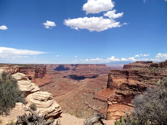
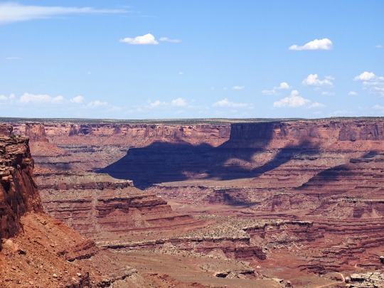
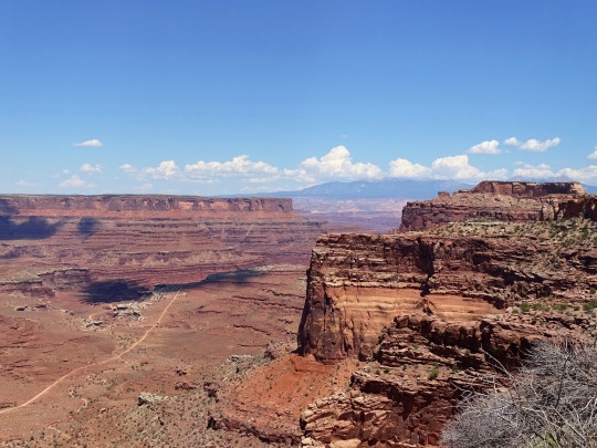

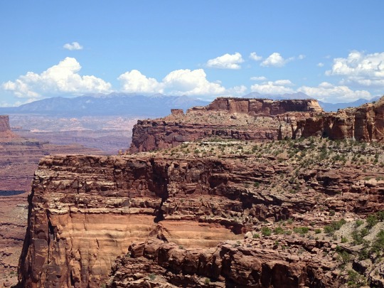
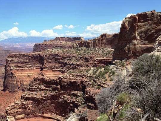
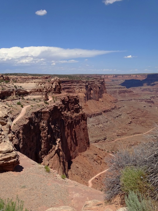
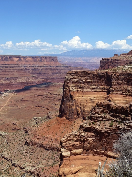
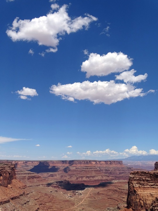
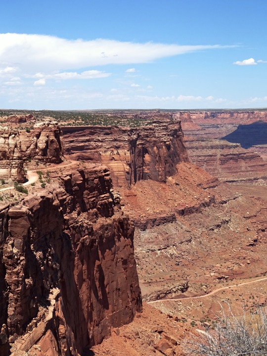
Buck Canyon Overlook, Canyonlands National Park (No. 1)
Buck Canyon Overlook is located in the Island in the Sky district of Canyonlands National Park, just off Grand View Point Road. Compared to some of the other overlooks in the area, Buck Canyon is less popular, but you still shouldn’t expect to have it to yourself.
The overlook is just a short walk along a paved pathway from the parking area. Fantastic views are to be had down into the Buck Canyon area. The La Sal Mountains provide a striking contrast against the red canyon rock, and you can even catch a glimpse of the Colorado River and the popular 4WD White Rim Road.
You might be able to see the faint outline of some other roads and seismic lines down in the canyon. These were constructed in the 1950s during a search for uranium and oil. Although these mining activities have long ceased, the impacts are still visible. Natural revegetation is slowly repairing these impacts, but it will take many years in this arid environment.
Source
#Shafer Trail Viewpoint#Buck Canyon Overlook#Canyonlands National Park#cliff#red rock#rock formation#view#blue sky#clouds#original photography#landscape#countryside#Island in the Sky#desert#Colorado Plateau#summer 2022#geology#La Sal Mountains#flora#bush#grass#nature#Western USA#Utah#USA#vacation#travel#road trip
6 notes
·
View notes
Photo

Shafer Trail Viewpoint, Canyonlands National Park, Moab, UT
0 notes
Photo
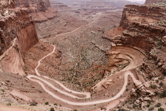
Shafer Trail Viewpoint, Canyonlands National Park, Moab, UT
0 notes