#Luvisol
Explore tagged Tumblr posts
Visit Tumblr Blog
Explore Tumblr blogs with no restrictions, modern design and the best experience.
Last Seen Tumblr Blogs


Fun Fact
Women make up for the other 50% of Tumblr’s audience.
Text
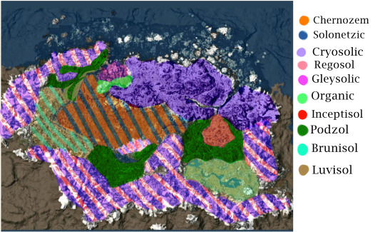
Long awaited, here is the soil map of Skyrim using the Canadian System of Soil classification. Brief description of my conclusions under the cut:
Chernozem: Whiterun Hold is likely home to the majority of Skyrim’s Chernozems. The majority of biological carbon sequestering in grassland environments are below ground, within the root systems. Organic material- humus, builds up, causing the upper layers of the soil to take on a dark colour. Additionally, Solonetzic soils could be present, peppered throughout the hold if the parent material to the soil is salty enough.
Cryosols are formed in Skyrim’s far North and high alpine regions. The mean annual soil temperature being 0 degrees C, with permafrost conditions. Freeze-thaw cycles lead to permafrost at the soils surface, but also cryoturbation: soil movement arising from frost action.
Additionally in mountainous regions, you would find Regosols. Soils which develop on unstable landforms and have had little time to develop, such as mountain slopes, or river floodplains.
Gleysols occur across the landscape of Skyrim, but primarily in Hjaalmarch. Gleysols are commonly found in depressions or low-lying areas where water saturates the soil continuously, leading to a molted characteristic to the soil.
Organic soils would primarily be found in the water saturated soils of Hjaalmarch. These are wetland soils found in forested areas and are commonly known as peat, muck, bogs or fens.
Borrowing from the USDA soil taxonomy, Inceptisols are light colored soils with moderate alteration, occurring under cool and cold climates. These soils would be found in the Eastmarch caldera.
Luvisols are associated with forested landscapes overlying loamy glacial till, or on clayey lacustrine deposits. Lake Honrich dominates a large portion of the Rift, according to UESP, seemingly draining from the lake. I believe this to be the site of a melted glacier, the lake being meltwater. Clay sediments are associated with lakes because of their deposition, coarser sediments bordering the lake near the shore, and finer particles at the deepest reaches. Additionally, at the end of the Karth river, where sandy deposits would be deposited at Solitude, before the stream looses power further down the river, leaving only clay to be deposited.
Podzols are associated with igneous parent materials, coniferous vegetation and high acidity. Primarily they are found in Falkreath Hold and Southern Eastmarch.
Brunisols are an intermediate stage between Regosols (undeveloped soils), and Podzol or Luvisols. I believe with the unstable, mountainous landscape of the Reach, soils would remain still rather undeveloped. Brunisols would also be interspersed among the Luvisols.
3K notes
·
View notes
Text
Edafología Epipediones luvisol
Luvisol Un Luvisol de lavar refiriéndose al lavado de arcilla de las capas superiores, para acumularse en las capas inferiores, donde frecuentemente se produce una acumulación de la arcilla y denota un claro enrojecimiento por la acumulación de óxidos de hierro. Es un Grupo de Suelos que se desarrollan dentro de las zonas con suaves pendientes o llanuras, en climas en los que existen…

View On WordPress
0 notes
Text
Impact of Cover-Crop Residuals on Soil Carbon Sequestration and Respiration- Juniper publishers

TGlobal policies encourage to lower greenhouse gas emissions in order to maintain climate change under the limit of +2°C at the horizon 2100. An important part of these gases are emitted from croplands and farms [1]. To reduce the environmental impact of croplands, diverse techniques and practices have been widely used by farmers, based on conservation agriculture (simplified cultivation techniques, cover-cropping, agroforestry, etc.). The use of these techniques has been adopted freely, according to the good will of farmers. Scientists have broadly studied these crop management practices in order to evaluate their impact on climate change [2–4]. Actual assessment of carbon emissions and storage capacities of croplands under such crop management practices had helped us to discriminate the practices useful for carbon accumulation. No-tillage has an important role to play in agriculture, mainly because of the great impact on soil bulk density and ease of crop germination. However, it is now well known and admitted that no-till have no significant impact alone on soil carbon storage capacities over the entire soil profile [5]. Cover-cropping is also an interesting and promising management practice to consider when accounting for climate resilient agroecosystems, soil carbon sequestration [6] and ecosystem services [7]. This practice can have very contrasted impacts on soil and the agroecosystem depending on sowing and destruction period, species used, for how long and how the residues are managed. Indeed, cover-cropping leads to improved biomass production and undoubtedly, to more crop residues. The impact of crop residues on soil carbon have been widely studied [8–10], but their impact on soil respiration still needs to be clarified. How do cover crop residues respiration change over the crop season? Soil respiration was measured with an infrared portable gas analyzer together with a soil respiration chamber (EGM4 and SRC1, PP Systems, Amesbury, USA). The study site was located in Southwest France (N 43° 24’ 38.057’’, E 0° 17’ 17.612’’, alt= 266 m) on a soil defined as a Stagnic Luvisol according to the World Reference Base for Soil Resource [11]. No-till and cover-cropping have been implemented for 20 years, which improved soil organic carbon content of 48.8% compared to conventional agricultural system. The cover crop was mainly composed of faba bean (Vicia faba), oat (Avena sativa) and triticale (×Triticosecale) for the last 4 years. We measured soil respiration with and without residues and for residues alone. We observed an increase of soil residues respiration over the season as well as of values dispersion (Figure 1). Very low level of respiration rate was observed from the 30th of June to the 10th of September, even if few points had respiration values in the range of values generally observed for soil respiration for temperate ecosystems [12]. But significant higher values of respiration were observed on the 29th of September and October (p value < 0.05). The increase in soil respiration across the season was attributed to the maturation of crop residues and their gradual transformation from fresh organic matter to labile and dissolved organic matter, more easily degradable for microorganisms. It then appeared that the degradation process of cover crops passed through different phases; slow degradation until the senescence of the cash crop (here maize), then degradation inducing significant respiration. It seems that maize senescence leaded to favorable conditions for cover crop residuals degradation. Usually, when maize enters senescence, farmers stop irrigation to let maize dry before harvesting. Cover crop residuals could reach their optimum degradation rate with optimum both soil moisture and temperature promoting respiration of residuals in this particular time period. A second hypothesis is that maize plants senescence could imply microorganisms within maize rhizosphere to look for other sustainable carbon source when maize roots stop to diffuse exudates in soil [13,14]. These microorganisms could change of substrate when maize exudates stop and move from exudates to surface carbon.
Conclusion
TCover-crops constitutes a good solution to improve soil carbon content sequestration, both by increasing biological activities notably through biomass accumulation and exudation, and abiotic impact on cropland (temperature and humidity control). However, the production of supplementary biomass induces supplementary carbon fluxes from the agroecosystems that needs to be taken into account when assessing carbon footprint of croplands.
To know more about Journal of Agriculture Research- https://juniperpublishers.com/artoaj/index.php
To know more about open access journal publishers click on Juniper publishers
0 notes
Text
Juniper Publishers-Open Access Journal of Environmental Sciences & Natural Resources
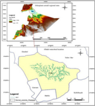
Analysis of Factors Affecting the Sustainability of Elbahi Micro-Dam Catchment, Near Jigjiga Town, Ethiopia Somali Regional State, Ethiopia
Authored by Yohannes Gerezihier Gebremedhin
Abstract
Construction of micro dams to harvest the available surface water resources of dry land area is inevitable. Elbahi micro-dam is located near to Jigjiga town in Ethiopia Somali Regional state; it was constructed from 1986-1993 with multi-purpose dam to serve the community as a source of water supply for irrigation, domestic and livestock consumptions, and to protecting Jigjiga town from flood problems. Elbahi-micro dam watershed has bi-modal rainfall distribution. The larger amount of mean monthly precipitation of Elbahi-micro dam watershed received during the main rainy season which extends from March to May while the second rainy season when lesser amount of mean monthly precipitation received extends from July to September. The mean annual precipitation in Elbahi micro dam watershed is estimated as 550.1mm. The major soil classes in the Elbahi micro-dam watershed are; Dystric nitisols (48%), Vertic cambisols (50%) and chromic luvisols (2%), which affect soil degradation differently.
For more Open Access Journals in Juniper Publishers please click on: https://juniperpublishers.com/
For more articles in Open Access Journal of Environmental Sciences & Natural Resources please click on: https://juniperpublishers.com/ijesnr/
To know more about Peer Review Journal of Environmental Sciences & Natural Resources
To read more…Fulltext please click on: https://juniperpublishers.com/ijesnr/IJESNR.MS.ID.555925.php
#Juniper Publishers#Juniper Publishers Review#Elbahi Micro-Dam#Sustainability#Watershed#Factors Affecting#Area description#Rainfall condition
0 notes
Text
Selenium content of alfalfa grown on Orthic Gray Luvisolic and Carbonated Orthic Gleysolic soils
http://dlvr.it/PPMnfp
0 notes
Video
youtube
What is TERRA ROSSA? What does TERRA ROSSA mean? TERRA ROSSA meaning - TERRA ROSSA pronunciation - TERRA ROSSA translation - TERRA ROSSA definition - TERRA ROSSA explanation - How to pronounce TERRA ROSSA? Source: Wikipedia.org article, adapted under http://ift.tt/yjiNZw license. Terra rossa ( Italian for "red soil") is a type of red clay soil produced by the weathering of limestone. When limestone weathers, the clay contained in the rocks is left behind, along with any other non-soluble rock material. Under oxidizing conditions, when the soils are above the water table, iron oxide (rust) forms in the clay. This gives it a characteristic red to orange colour. Terra rossa is typically found in regions with a Mediterranean climate but can also be seen elsewhere, for example in Prince Edward Island, Canada. Compared to most clay soils, terra rossa has surprisingly good drainage characteristics. This makes it a popular soil type for wine production. Among other wine regions, it is found in La Mancha in Spain and Coonawarra in Australia. In pedology, red Mediterranean soil, also known as terra rossa (Italian for "red soil") is a soil classification that has been formally superseded by the formal classifications of systems such as the FAO soil classification, but that is still in common use. The terra rossa classification was still, as of 1997, a part of the national soil classifications of countries such as Israel and Italy. The UNESCO/FAO World map equivalents are the chromic luvisols (a sub-order of the luvisols), and the USDA soil taxonomy equivalent is the rhodustalfs (a sub-order of the ustalfs). The classification denotes red-coloured soils (sometimes called "red rendzinas") which develop in or on the karstic landscape of the limestones of the Miocene and earlier periods, as well as calcretes in regions where the modern Mediterranean climate is predominant. The most accelerated development of red Mediterranean soils occurred from the Miocene to the Late Pleistocene, due to the large amount of climate fluctuation in those periods. Terra rossa occurs in areas where heavy rainfall dissolves carbon from the calcium carbonate parent rock and silicates are leached out of the soil to leave residual deposits that are rich in iron hydroxides, the cause of the red colour. Such areas are usually depressions within the limestone, or areas where the vegetation is garrigue (low-lying scrub).
0 notes
Note
just a heads up that it looks like your soil map is missing the clay-brown color you used for luvisols around the rift and southwest of solitude. otherwise very cool!
Thanks for pointing that out! That should be fixed now!
6 notes
·
View notes
Text
Finca Higueruela CSIC
Que es la Finca Higueruela de CSIC Finca Higueruela (Toledo), mas concretamente La Estación de Campo Experimental de La Higueruela (HEFS) , es un espacio de unas 90Ha propiedad del CSIC creado en 1972 donde se realizan trabajos científicos y experimentales donde se analizan diversos factores relacionaos con la ecología, el cambio climático, la biodiversidad, la erosión de los suelos y la…

View On WordPress
#barbecho#cambio climático#cereales#Ecología#Edafologia#epipedión#estudios científicos#experimentación#finca higueruela#girasol#Luvisol#produccion#setos#trigo#Vertisol
0 notes
Text
Carbon Stock of Luvisols as Influenced by Cropping System of Abela Lida, Southern Ethiopia-Juniper Publishers

Assessing and quantifying carbon stock by taking into consideration the type of land use and soil type would have great contribution for an appropriate land use decision and sustainable carbon soil stock management. The purpose of this study was to examine the influence of cropping systems on carbon stock of Luvisols of Abela Lida, Southern Ethiopia. Three representative adjacent cropping systems (enset, coffee and maize-haricot bean intercropping) were considered for the study. The mean values of soil organic carbon (SOC) ranged from 1.72 to 2.75%, medium to high status, respectively. The highest mean value of SOC (2.75%) was recorded in soils under coffee. In the other hand, the lowest mean value (1.72%) of SOC was recorded under the soils of maize-haricot bean intercropping. The results of the study showed significant difference (P≤ 0.05) in soil organic carbon stock under the different cropping systems. Soil under coffee cropping systems had significantly higher values of SOCst (51.01.9Mg ha-1) than enset and maize-haricot bean intercropping (46.61 and 34.58Mg ha-1, respectively). It could be concluded that cropping systems have significant influence on soil organic carbon status and carbon stocks of the soils of an area. Therefore, it is important and advisable to consider cropping systems of a given area for soil management to optimize organic carbon status and carbon stock in a sustainable manner
Keywords: Land use; Organic carbon; Soil management
Introduction
Carbon exists as inseparable components of biomass and soil organic matter. Its storage in soil organic matter is important in mitigating global climate change and improves the livelihood of resource- poor farmers [1]. Soil organic carbon represents a key indicator for soil quality [2], both for agricultural functions (production and economy), especially for resilience and sustainability of agriculture and for environmental functions (carbon sequestration and air quality)[3]. Due to these facts, carbon stocks have received considerable attention in the recent past [4].
Soil organic carbon (SOC) plays an important role in the global carbon (C) cycle. Soils have the potential to sequester carbon from the atmosphere with proper management [5]. It is generally assumed that soils are the largest C sinks in terrestrial ecosystems [6] with C stock of (~1500Pg), which approximately twice the amount held in the atmosphere and three times the amount contained in terrestrial vegetation [7]. In the other hand, the global emission of soil carbon dioxide is well recognized as one of the largest contributors to worldwide carbon fluxes [8]. Therefore, increasing attention has been paid to soil carbon sequestration over recent decades [9].
Carbon stock of an area could be influenced by land use, soil type and soil management practices. The amount of carbon in any soil is a function of the soil forming factors including climate, relief, organisms, parent material, and time. Over the centuries, humans, usually included as part of the “organisms” factor, have profoundly influenced the dynamics and sequestration of carbon in soils by their land use and management practices [10,11]. Generally, the type of land use system is an important factor that controls SOC levels [12,13]. Therefore, assessing and quantifying carbon stock by taking into consideration the type of land use and soil type would have great contribution for an appropriate land use decision and sustainable carbon soil stock management for the study area, where there is little information in this regard. It has also been suggested that monitoring the effect of land use on soil quality attributes within an ecosystem can provide a useful way to control land degradation and achievement of sustainable management [11]. Moreover, in order to estimate the change in the C stocks of soils, it is first necessary to establish baseline data [14].
Materials and Methods
Description of the study area
The study was conducted at Abela Lida, mid altitude parts of Shebedino district of Sidama zone in southern region of Ethiopia. It has an altitude of 1877masl with a bimodal rainfall pattern where the short rain falls from mid-February to April and the long rain fall during the period of June to September. The mean annual precipitation ranges between 1200-2500 mm and mean annual temperature ranges 12-20°C [15].
The soil type of the study area is Chromic Luvisols [16] and it is locally characterized as Shakado, Kakacha and Dora. The base for their classification is the fertility status of the soils. Shakado soils are found near the farmers’ house, which developed through the continuous application of organic manure and house refuses, and have deep top soils of very dark brown color. The soil is friable and very easy to manipulate. This type of soil is mainly planted enset and coffee along with high value fruits and vegetables. Kakacha soils are less fertile than Shakado. They are found at some distance from the homestead and seldom received manure and used mainly to maize-haricot bean cropping. Dora soils, on the other hand are characterized as the least fertile soils of the area and very small area support coffee plantation, although the trees give production once in two years.
Major crops grown in the study area are enset, coffee, maize and haricot bean. The enset and coffee are traditional component of the farming system of the area. From fruits and vegetable, avocado, banana, orange, papaya and sugar cane are common in the area.
Soil sampling and analysis
Three representative adjacent cropping systems (enset, coffee and maiz-haricot bean intercropping) were considered for the study. In each cropping system, four composite soil samples were taken by thoroughly mixing forty subsamples that had been taken randomly in three replications within 0 to 20cm depth. Twelve undisturbed samples were also collected with core sampler for determination of bulk density. The samples were air-dried, ground with mortar and pestle to pass through 2mm sieve.
Bulk densities were determined by core sampling [17]. Particle size distribution was determined by Bouyoucos hydrometer method [18]. Soil pH was measured using a 1:2.5 soil to water ratio [19], whereas OC was determined by wet digestion method [20].
The soil organic carbon stock of the different cropping systems was estimated with the following equation [21]:
Where: SOCst is soil organic carbon stock (Mg C ha-1); SOC the soil organic carbon concentration (%); BD is the bulk density (gcm-3); D is the depth (cm); multiplied by 100 to convert from g C cm-2 to Mg C ha-1.
Statistical analysis
The analysis of variance (ANOVA) was performed using General Linear Model (GLM) procedure [22] version 9.2. Mean separation was carried out using LSD at P < 0.05.
Results and Discussion
Selected soil physical and chemical properties of the study area
The selected soil physical and chemical properties of the study area are presented in Table 1. The textural class of the study area was loam, irrespective of the cropping systems. Texture as an inherent characteristic of the soils does not easily influence by cropping system and soil fertility management. The highest (29.08%) mean value of clay was obtained from maize-haricot bean cropping system, whereas relatively the lowest (24.07%) mean value of clay was recorded under enset cropping system. In previous study, it was stated that highest clay content of soils was recorded under maize and the suggested reason was due to accelerated weathering as the result of disturbance caused by continuous cultivation as compared to enset and coffee cropping systems that have minimum disturbance [23]. The highest (40.65%) mean value of silt was recorded under enset, while the lowest (36.64%) was obtained under maize-haricot bean intercropping. With respect to sand, the highest (39.01%) mean value was recorded under coffee cropping system.
The mean values for bulk density of surface soils (0-20cm) of the considered cropping systems ranged from 0.93 1.02gm/ cm3 (Table 1). The result of the study agrees with Brady and Weil [24], who indicated that the range of bulk density between 0.8 and 1.2g/cm3 is a typical characteristic of loamy A horizon. The bulk density values of the soils under enset and coffee cropping systems are relatively lower as compared to that of maizeharicot bean intercropping. The reasons for relatively lower bulk density in the case of enset and coffee cropping systems might be intensive manure application, decomposition of fallen leaves, left over of harvesting and processing. [24,25] stated that dung decomposition plays a role in reducing surface compaction by increasing the volume of soils macro-pores. On the other hand, relatively the highest bulk density value was under maize-haricot bean intercropping, which might be due to the low levels of organic matter and compaction effect as a result of continuous tillage activities. These soils did not receive application of manure and there has been complete removal of crop residues from the fields for different purposes
The mean soil pH values of the considered cropping systems ranged from 6.31 to 7.59. The highest mean soil pH value (7.59) recorded in soils under enset, which might be due to the relatively high amount of manure application. Previous study confirmed that the application of farmyard manure led to higher soil pH [26,27]. Moreover, decomposition of the large enset leaves biomass, left over of harvesting and processing enrich exchangeable bases that are responsible for high soil pH values. The mean pH value (6.52) under coffee was relatively low, basic cations removal due to harvesting might be the reason. Heavy cropping coffee over a period of years would reduce level of potassium and the pH would fall [28]. Relatively the lowest mean value of pH was recorded under maize-haricot bean. The reason might be due to long-term cultivation and fertilization. The pH of the surface few centimeters of soil usually decreased rapidly when high rates of nitrogen fertilizers is used [29].
The effluence of cropping system on carbon stock of Luvisols
The mean values of soil organic carbon (SOC) ranged from 1.72 to 2.75% (Table 2), medium to high status respectively [30]. The highest mean value of SOC (2.75%) was recorded in soils under coffee, which might be due to the decomposition of fallen leaves of shade trees and grasses. Generally, the mean values of SOC were high in coffee and enset cropping systems. The application of manure and decomposition of fallen leaves might be the reason. The no tillage practices of the farmers in these cropping systems may also contribute these values. Long term no tillage systems protect SOC through formation of stable sand and silt sized particles [31]. It was reported that SOC was significantly higher in the upper 0 to 5 cm depth under no tillage farm [32]. The lowest mean value (1.72%) SOC was recorded under the soils of maize-haricot bean intercropping. The reason could be continuous oxidation of organic matter due to intensive cultivation and complete crop residue removal for different purposes. Tillage practices can alter the distribution of SOC. Several studies under varies soils and climate conditions have shown the impact of tillage on SOC [33].
The mean values of soil organic carbon stock (SOCts) of the copping systems ranged between 34.58 to 51.01 Mg ha-1 within 0 to 20cm soil depth. There were significant differences (p<0.05) in mean values of SOCst among the cropping systems (Table 2). The highest mean value of SOCst (51.01Mg ha-1) was obtained in coffee cropping system. In this cropping system, there was high status of organic matter due to the decomposition of fallen leaves of shed trees and continuous application of manure. In the other hand, the lowest mean value (34.38 Mg ha-1) was obtained in maizeharicot bean intercropping. Comparable result was obtained from cultivated land of Kersa sub watershed, eastern Ethiopia [34]. In this cropping system, the organic matter was depleted duet to continuous cultivation and complete removal of crop residues.
Conclusion
The findings of this study clearly showed that cropping systems significantly influenced the soil organic carbon contents and carbon stock. The organic content and carbon stock of coffee and enset cropping systems were greater than the maize-haricot bean intercropping. It is therefore important and advisable to consider cropping systems of a given area to optimize organic carbon status and carbon stock of the soils in sustainable manner.
To know more about Journal of Agriculture Research- https://juniperpublishers.com/artoaj/index.php
To know more about open access journal publishers click on Juniper publishers
0 notes
Text
I want to expand on this a bit more, because the terminology is a bit much, a few have expressed interest in this as a writing reference, but most importantly: i like dirt
Chernozems are dark colored soils, almost black, they're very fertile, making Whiterun hold the bread basket of Skyrim, such as we get indications towards in game. Solonetzic soils meanwhile, are saltier and less suitable for growth, having a hard layer of clay impacting the development of roots. They form interesting sorts of structures called roundtops in the lower horizons:

As I stated, cryosols are permafrost soils. When it's winter, the soil contracts, creating cracks. In the summer water infiltrates these cracks and eventually will freeze again, forming ice wedges. Over time these expand, and create some really beautiful patterns.

Regosols are young soils, taking on characteristics of the parent geologic material. They don't yet have the developed layers soils typically have.
Gleysolic soils are moulted, having steaks of colour in their horizons, typically grey.
Organic soils are very richly coloured, sometimes very dark with the addition of organic material. They might be fibrous if you examine them closely, this is from decomposed leaf litter or other organic material.
I picked inceptisol for the caldera at Eastmarch because of it's light colour, assuming it's fairly unweathered from it's parent geological material and young.
Podzols have light coloured horizons near their surface, horizons which face intense chemical weathering. Metal ions in the soil form organic complexes with products of decomposition and move downwards as the water drains through the soil. Brunisols look very similar but have slightly different classification criteria.

Finally, Luvisols are very similar to Podzols and Brunisols, but represent a stage between Regolith soils (undeveloped soils) and Luvisols or Podzols, not quite yet having that intensely light colored Ae horizon.
Long awaited, here is the soil map of Skyrim using the Canadian System of Soil classification. Brief description of my conclusions under the cut:
Chernozem: Whiterun Hold is likely home to the majority of Skyrim’s Chernozems. The majority of biological carbon sequestering in grassland environments are below ground, within the root systems. Organic material- humus, builds up, causing the upper layers of the soil to take on a dark colour. Additionally, Solonetzic soils could be present, peppered throughout the hold if the parent material to the soil is salty enough.
Cryosols are formed in Skyrim’s far North and high alpine regions. The mean annual soil temperature being 0 degrees C, with permafrost conditions. Freeze-thaw cycles lead to permafrost at the soils surface, but also cryoturbation: soil movement arising from frost action.
Additionally in mountainous regions, you would find Regosols. Soils which develop on unstable landforms and have had little time to develop, such as mountain slopes, or river floodplains.
Gleysols occur across the landscape of Skyrim, but primarily in Hjaalmarch. Gleysols are commonly found in depressions or low-lying areas where water saturates the soil continuously, leading to a molted characteristic to the soil.
Organic soils would primarily be found in the water saturated soils of Hjaalmarch. These are wetland soils found in forested areas and are commonly known as peat, muck, bogs or fens.
Borrowing from the USDA soil taxonomy, Inceptisols are light colored soils with moderate alteration, occurring under cool and cold climates. These soils would be found in the Eastmarch caldera.
Luvisols are associated with forested landscapes overlying loamy glacial till, or on clayey lacustrine deposits. Lake Honrich dominates a large portion of the Rift, according to UESP, seemingly draining from the lake. I believe this to be the site of a melted glacier, the lake being meltwater. Clay sediments are associated with lakes because of their deposition, coarser sediments bordering the lake near the shore, and finer particles at the deepest reaches. Additionally, at the end of the Karth river, where sandy deposits would be deposited at Solitude, before the stream looses power further down the river, leaving only clay to be deposited.
Podzols are associated with igneous parent materials, coniferous vegetation and high acidity. Primarily they are found in Falkreath Hold and Southern Eastmarch.
Brunisols are an intermediate stage between Regosols (undeveloped soils), and Podzol or Luvisols. I believe with the unstable, mountainous landscape of the Reach, soils would remain still rather undeveloped. Brunisols would also be interspersed among the Luvisols.
3K notes
·
View notes