#India China Aksai Chin
Explore tagged Tumblr posts
Visit Tumblr Blog
Explore Tumblr blogs with no restrictions, modern design and the best experience.
Last Seen Tumblr Blogs


Fun Fact
If you dial 1-866-584-6757, you can leave an audio post for your followers.
Text
भारत और चीन के युद्ध की शुरुआत कहां से हुई?
आज हम बात करेंगे, दो ऐसे पड़ोसियों की जो एशिया के साथ-साथ पूरी दुनिया में एक बहुत ऊंचा मुकाम रखते है। टाइटल से यह स्पष्ट समझा जा सकता है कि बात यहां पर भारत और चीन के विषय में ही होने वाली है, तो आइए बेझिझक और बिना लाग लपेट मुद्दे पर आते है। भारत-चीन का युद्ध खासतौर से 1962 में कई कारणों से हुआ था। शुरू से ही पाकिस्तान का हमदर्द रहा चीन भारत को खुद से आगे बढ़ता हुआ नहीं देख सका। हालांकि, 1962 का…
#Aksai Chin map#Causes of conflict between India and China#china-india border dispute 2024#How much land India lost to China in 1962 war#India China border dispute map#india-china border dispute pdf#india-china border dispute upsc#india-china war 1967#Prakhar Pandey
0 notes
Text
India says it has lodged a "strong protest" with China over a new map that lays claim to its territory.
Indian media have reported that the map shows the north-eastern state of Arunachal Pradesh and the disputed Aksai Chin plateau as China's territory.
It was released by China's ministry of natural resources on Monday.
"We reject these claims as they have no basis," India's foreign ministry spokesperson Arindam Bagchi said.
He added that such steps by China "only complicate the resolution of the boundary question".
Beijing has not officially responded yet.
India's Foreign Minister S Jaishankar also called China's claim "absurd".
"China has even in the past put out maps which claim the territories which are not China's, which belong to other countries. This is an old habit of theirs," he told TV channel NDTV on Tuesday.
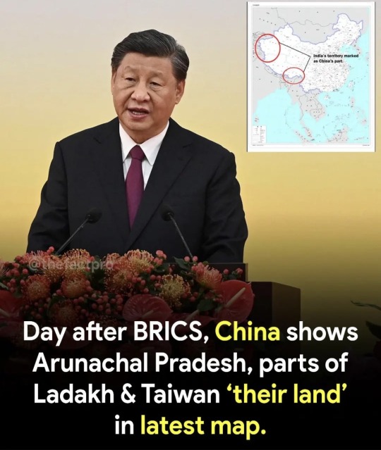
India's protest comes days after Prime Minister Narendra Modi and Chinese President Xi Jinping spoke on the sidelines of the Brics summit in South Africa. An Indian official said afterwards that the two countries had agreed to "intensify efforts at expeditious disengagement and de-escalation" along the disputed border.
Shadow of 60-year-old war at India-China flashpoint
The Indian monastery town coveted by China
India has often reacted angrily to China's attempts to stake claim to its territory.
The source of the tension between the neighbours is a disputed 3,440km (2,100 mile)-long de facto border along the Himalayas - called the Line of Actual Control, or LAC - which is poorly demarcated. The presence of rivers, lakes and snowcaps means the line can shift in places.
Soldiers on either side come face to face at many points, which can spark tensions - the last time being in December when Indian and Chinese troops clashed along the border in the town of Tawang.
China says it considers the whole of Arunachal Pradesh its territory, calling it "South Tibet" - a claim India firmly rejects. India claims the Aksai Chin plateau in the Himalayas, which is controlled by China.
In April, Delhi reacted sharply to China's attempts to rename 11 places in Arunachal Pradesh, saying the state would always be "an "integral and inalienable part of India".
Relations between India and China have worsened since 2020, when their troops were involved in a deadly clash at the Galwan valley in Ladakh - it was the first fatal confrontation between the two sides since 1975.
8 notes
·
View notes
Text
Entire Ladakh Knows...": Rahul Gandhi After China Rahul Gandhi question’s pm Modi
China’s “standard” map shows Aksai Chin, which it occupied in the 1962 war, and Arunachal Pradesh, which it claims as South Tibet, as part of its territory. Congress leader Rahul Gandhi today demanded a statement from Prime Minister Narendra Modi in response to China’s release of a map that claims ownership of Aksai Chin and Arunachal Pradesh, which has been categorically rejected by India. On…

View On WordPress
2 notes
·
View notes
Text
Unearthing Adventures: The Trails of Kongka La Pass and Tsaga La Pass

Exploring the hidden gems of Ladakh is an adventure like no other. Nestled amidst the towering Himalayas, two of its most intriguing destinations are Kongka La Pass and Tsaga La Pass. These remote passes, steeped in mystery and offering breathtaking vistas, provide an unparalleled experience for travelers seeking both natural beauty and enigmatic tales. With Kongka La Pass and Tsaga La Pass as our primary focus, let's embark on a journey to uncover the allure of these remarkable locations.
Kongka La Pass
Kongka La Pass, located on the disputed border between India and China, is not just a geographical landmark but also a point of fascination and intrigue. The pass is situated in the Ladakh region of India, at an altitude of approximately 5,171 meters (16,965 feet) above sea level. This high-altitude pass is part of the contentious area known as Aksai Chin, which both India and China claim as their own. Despite its geopolitical significance, Kongka La Pass remains relatively unknown to mainstream travelers, making it a unique destination for those who venture into its rugged terrain.
The landscape around Kongka La Pass is characterized by stark, desolate beauty. The barren, rocky expanses are punctuated by snow-capped peaks, creating a dramatic and otherworldly environment. This area is also known for its harsh weather conditions, with freezing temperatures and strong winds prevailing for most of the year. The pass is not easily accessible, requiring a challenging trek that tests the endurance and resilience of even the most seasoned adventurers.
One of the most intriguing aspects of Kongka La Pass is the numerous reports of unidentified flying objects (UFOs) and extraterrestrial activity. Local legends and various accounts suggest that the area is a hotspot for mysterious sightings, adding an element of mystique to the already enigmatic landscape. Whether these stories are rooted in fact or fiction, they contribute to the allure of Kongka La Pass, drawing curiosity seekers and conspiracy theorists alike.
Tsaga La Pass
Tsaga La Pass, on the other hand, lies further to the southeast of Kongka La Pass, near the border between India and Tibet. Situated at an altitude of approximately 4,620 meters (15,157 feet), Tsaga La Pass is less known for its geopolitical significance and more for its natural beauty and cultural heritage. The pass serves as a gateway to the Changthang region, an area renowned for its stunning landscapes and rich biodiversity.
The journey to Tsaga La Pass takes travelers through some of the most picturesque scenery in Ladakh. Rolling hills, expansive plateaus, and pristine lakes define the landscape, offering endless opportunities for photography and nature appreciation. The region is also home to the nomadic Changpa people, who have lived in harmony with this harsh environment for centuries. Their unique way of life, centered around yak and goat herding, provides a fascinating glimpse into the cultural heritage of Ladakh.

Wildlife enthusiasts will find Tsaga La Pass particularly appealing, as the Changthang region is a haven for rare and endangered species. The area is part of the larger Tibetan Plateau, known for its unique flora and fauna. Visitors may spot the elusive snow leopard, Tibetan wild ass (kiang), and various species of migratory birds. The high-altitude wetlands and marshes around Tsaga La Pass are especially important for birdwatching, attracting avian species from across the globe.
Comparing the Two Passes
While both Kongka La Pass and Tsaga La Pass offer unique experiences, they cater to different types of travelers. Kongka La Pass, with its mysterious aura and challenging terrain, appeals to those seeking adventure and intrigue. The harsh conditions and the tales of UFO sightings make it a destination for thrill-seekers and explorers looking to venture off the beaten path.
In contrast, Tsaga La Pass is more suited for travelers who appreciate natural beauty, wildlife, and cultural experiences. The scenic landscapes and the opportunity to interact with the Changpa nomads provide a more serene and enriching journey. Tsaga La Pass is also relatively more accessible compared to the remote and challenging Kongka La Pass.
Travel Tips for Visiting Kongka La Pass and Tsaga La Pass
When planning a visit to these remote passes, preparation is key. Here are some essential travel tips to ensure a safe and enjoyable journey:
Acclimatization: Both Kongka La Pass and Tsaga La Pass are situated at high altitudes, making acclimatization crucial. Spend a few days in Leh or other lower-altitude areas to allow your body to adjust to the thin air.
Permits: Ensure you have the necessary permits to visit these areas. Due to their proximity to international borders, special permits are often required, which can be obtained from local authorities in Leh.
Weather Conditions: The weather in these high-altitude regions can be unpredictable. Pack appropriate clothing, including layers, thermal wear, and waterproof gear, to stay warm and dry.
Physical Fitness: Both passes require a good level of physical fitness. Engage in regular exercise and cardio training to build stamina and endurance for the challenging treks.
Local Guides: Hiring a local guide is highly recommended. They have invaluable knowledge of the terrain, weather patterns, and cultural nuances, ensuring a safer and more informative experience.
Respect Local Culture: The Changpa nomads and other local communities have rich cultural traditions. Show respect for their customs and way of life by being mindful of local etiquette and practices.
Wildlife Conservation: The Changthang region is a protected area with diverse wildlife. Practice responsible tourism by maintaining a safe distance from animals, not disturbing their natural habitats, and adhering to park regulations.
Hydration and Nutrition: Staying hydrated is crucial at high altitudes. Drink plenty of water and carry energy-boosting snacks to keep your energy levels up during the trek.
Exploring Kongka La Pass and Tsaga La Pass offers a unique opportunity to experience the contrasting yet complementary aspects of Ladakh's natural and cultural heritage. Whether you are drawn to the mysterious allure of Kongka La Pass or the serene beauty of Tsaga La Pass, these remote destinations promise an unforgettable adventure. With proper preparation and a spirit of exploration, you can uncover the hidden gems of Ladakh and create memories that will last a lifetime.
0 notes
Photo
according to this map india's taken aksai chin from china but gilgit baltistan is still with pakistan ..

India Flag Redesign by 6 years old son,
from /r/vexillology Top comment: incredible fucking power move putting the old boring flag in the corner
#i hope the son gets exposed to anti national marxists#also taj mahal in the centre is making me lose it i just know sanghis would be fuming
112 notes
·
View notes
Text
India, China and Denmark call for Kashmir’s Independence
by Yonhap News Reporter
UNSC: New York, March. 2 (Yonhap) – India, China, and Denmark Delegates are pushing to establish a new shared provisional government of Kashmir, where different countries will have control over the Aksai Chin and Arunachal Pradesh regions along the India-China border over periods of time.
As one of the largest undisputed borders between the two countries, Aksai Chin: a mountainous region, serves as an integral safeguard and deterrent in China’s favor to pose a threat to India’s Sovereignty. Arunachal Pradesh, a state in North-East India, has a strategic geographical location, heritage sites, as well as a variety of natural resources such as mineral oils and gas. Therefore, the ownership of this area by any one nation would lead to unfair advantages over the other.
“Kashmir may become an independent state” The Delegate of Denmark states in an interview with a reporter from Yonhap News. The control over Kashmir is currently being debated within the UNSC council and is unconfirmed.
1 note
·
View note
Text
21/10/2023:POLICE COMMEMORATION DAY!
Police Commemoration Day Police Commemoration Day The Police Commemoration Day is observed on 21st October every year This day is observed as Martyr’s Day in all police forces of India The day commemorates the sacrifices of ten policemen who sacrificed their life while defending our borders with China in 1959. Hot Springs in Aksai Chin Hot Spring in Aksai Chin in Ladakh is situated between…

View On WordPress
0 notes
Text
Answer to Why should India not counter China's mischief by showing Aksai Chin and Tibet as Indian territories and publish a map showing them in India? by Darren (Jrong) Sohkhlet https://www.quora.com/Why-should-India-not-counter-Chinas-mischief-by-showing-Aksai-Chin-and-Tibet-as-Indian-territories-and-publish-a-map-showing-them-in-India/answer/Darren-Jrong-Sohkhlet?ch=18&oid=1477743698423827&share=87943b9a&srid=hWerkF&target_type=answer
0 notes
Text
China considers Aksai Chin as part of its Xinjiang province and Tibet. Currently, China controls around 38,000 square kilometers of land in Aksai Chin.
A report from the British think tank Chatham House points out that the Chinese military is strongly positioned in the Aksai Chin region and is likely to remain there.
It has also been noted that the Chinese patrols are trying to hinder the development of India’s strategic airstrip at Daulat Beg Oldi, a logistics and transport base for Indian operations at high altitudes and is noted to be the highest airstrip in the world. It is crucial for supporting Indian units against both China and Pakistan.

0 notes
Link
0 notes
Text
Malaysia, India and Taiwan reject China's new territorial map
Nikkei Asia By Amy Chew August 31, 2023 KUALA LUMPUR — Malaysia and India have lodged protests against a new map published by China this week that appears to expand Beijing’s territorial claims. The 2023 edition of China’s “standard map,” published Monday on China’s Ministry of Natural Resources website, claims the Indian state of Arunachal Pradesh and the Aksai Chin plateau as Chinese territory.…

View On WordPress
0 notes
Text
India protests over China’s ‘absurd’ territorial claims
New Delhi has lodged a diplomatic protest with Beijing over a new map that “lays claim to India’s territory” The Indian government said on Tuesday it has lodged a protest with Beijing over a new “standard map” which shows the Indian state of Arunachal Pradesh and the Aksai Chin plateau as parts of China. “We…India protests over China’s ‘absurd’ territorial claims
View On WordPress
0 notes
Link
[ad_1] New Delhi [India], August 30 (ANI): A day after China released its standard map that included India's Aksai Chin and Arunachal Pradesh, Congress MLA, Ninong Ering has written to Prime Minister Narendra Modi urging him to raise the issue of People's Republic of China's aggression in the scheduled G20 Summit in Delhi on September 9-10.In his letter to the PM on Tuesday, the Congress leader said that the'deliberate incident' on the part of the PRC has invoked deep resentment among the people of Arunachal Pradesh."This unforeseen, unfortunate yet deliberate incident on the part of PRC has invoked deep resentment among the people of Arunachal Pradesh, it is in common knowledge that the PRC has earlier too tried to assert its claim over Arunachal Pradesh by renaming 11 locations in April 2023, 15 locations in 2021 and 6 places in 2017," Ering said.The Congress MLA who represents the Pashighat-west seat, a constituency bordering the Chinese-controlled Tibet Autonomous Region, in the Arunachal Pradesh legislative assembly, said that the recent release of the'PRC Standard Map' is a culmination of their nefarious plans and a matter of importance since Arunachal Pradesh is an integral part of India and has scarred memories of the 1962 Sino-Indian war.In his letter, he also mentioned the Galwan Valley clash between the troops of India and China."As you know, India is engaged in combat with an aggressive PRC along the Indo-Tibetan border in the Himalayas and 20 of Indian Army personnel gave their lives while defending India's frontiers against the PLA in Galwan Valley in 2020. Prior to this, you have emphasized that no one can seize an inch of India's land. Referring to the India-PRC standoff in the Tawang district of Arunachal Pradesh in December 2022, the Union Home Minister Amit Shah earlier stated that the government is committed to ensuring that not a single inch of India's soil is compromised," the Congress MLA wrote. Asserting that he has full faith in the wisdom and the might of the Indian Army in defending the Line of Control and Line of Actual Control, the Congress leader said that this release of the map was an attack on India's sovereignty and integrity."Being an elected representative of Arunachal Pradesh's Pashighat-West seat, I appeal to you to discuss this matter of PRC unilaterally making changes in its map with Chinese President Xi Jinping in the upcoming G20 Summit in New Delhi on September 9-10," Ering said. "I would like to emphasize that this matter should be highlighted and condemned globally by relevant state-run media in order to appraise the world of the PRC's aggression. This is extremely important since any more silence on this issue will be considered and even advertised by the PRC as a tacit approval of the Indian side on Chinese claims," he added.On August 28 China released the 2023 edition of its 'standard map' showing Arunachal Pradesh, which China claims as South Tibet and Aksai Chin occupied by it in the 1962 war as part of its territory. Taiwan and the disputed South China Sea are also included within the Chinese territory in the new map.India on Tuesday lodged a strong protest against China rejecting claims made by Beijing and said they have no basis to claim India's territory.The Ministry of External Affairs said that such steps from the Chinese side would only complicate the resolution of the boundary question.In response to media queries, the Official Spokesperson of the Ministry of External Affairs, Arindam Bagchi said: "We have today lodged a strong protest through diplomatic channels with the Chinese side on the so-called 2023 "standard map" of China that lays claim to India's territory.""We reject these claims as they have no basis. Such steps by the Chinese side only complicate the resolution of the boundary question," he added. (ANI) [ad_2]
0 notes
Text
#china released the 2023 edition of its territorial map as per its imagination, claiming Indian territories such as #arunachalpradesh and parts of #ladakh (Aksai Chin region) as its own. Apart from Indian territories, China also included #taiwan and the contentious 9-dash line in the #southchinasea
Notably, the map was released when India is all set to host the #G20 Summit on 9th September and 10th September. China is one of the G20 countries. Chinese President #xijinping is set to visit Delhi for the G20 Summit.

#surya#surya kulshreshtha#kulshreshtha#technology#india#suryakulshreshtha#android#life#programming#coding#g20 countries#g20summit#g20 nations#g20 presidency#china#global times
0 notes
Text
"India Takes a Stand: Bold Protest against China's New Map, Unveiling the Complexity of Boundary Tensions!"
India has rejected China’s “standard map” for 2023 and criticized the inclusion of Indian territory. The Ministry of External Affairs lodged a strong protest through diplomatic channels, stating that such actions by China complicate the resolution of the boundary issue. The release of the map, which claims Arunachal Pradesh and Aksai Chin as part of Chinese territory, was denounced by India’s…

View On WordPress
0 notes