#I still use gimp for the text function for maps and other things
Explore tagged Tumblr posts
Text
On Towns in RPGs, Part 6: Wait, Wasn't This About Maps?
In the first article in this series, I embarked on an ill-defined quest to figure out what, if anything, a town map is actually for in tabletop play.
In the second, I took a look at the common metaphor comparing towns to dungeons—unfavourably.
In the third, I proposed an alternate metaphor: that cities are more like forests than dungeons.
In the fourth, I looked at how forests are used in D&D to see what we could use when thinking about cities.
In the fifth, I got into to the nuts and bolts of designing cities for use in D&D.
Now, we're going to break out the Gimp (or, for you fancy folks, Photoshop) and make some maps.
Splitting the Map in Two
Back in the first article, I compared these two images of medieval Nuremberg:
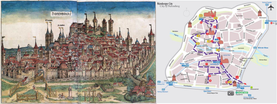
In that article, I argued that we can make things easier for ourselves as DMs, and be more effective besides, by splitting a D&D map into two separate illustrations: one to set the tone, and one for crunch, much like the tourist map on the right. It's ugly as sin, but if you're a tourist in old Nuremberg, it tells you exactly what you need and no more. Functionally, this particular map wouldn't be very useful in D&D (again, it emphasizes actual streets, which we don't care about, because towns are not dungeons) but, because towns are forests, we can look to existing high-functioning D&D map design—that is to say, regional maps—as inspiration.
Cutting Out the Illustration
By adding an illustration, which, unless you're publishing this city, you can just steal from the internet, you're taking a lot of the load off of your map. The map no longer has to be particularly pretty, it doesn’t have to show individual buildings or roads, and it doesn't have to fit any particular theme. All it has to do is be easy to read, functional, and packed with information. Think about it a little like a character sheet for your city.
What's Left for the Map?
Most D&D town maps try to give a literal depiction of the exact layout of the streets (which isn't useful) and also serve as an evocative piece of art (which is, but can be done better and more easily in other means), but doesn't provide much in the way of useful gameplay information. So… what is useful gameplay information?
Travel Time
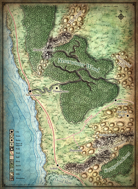
Consider the map of the area around Neverwinter Woods that I used earlier. Somewhere in pretty much every RPG rulebook is a table showing daily travel speeds through various different terrain types. In D&D 3.5, for example, an unencumbered human can cover 18 miles overland on flat ground, or 12 miles per day through forests. These values can be increased by major highways. Knowing this information, it becomes trivial for the DM to quickly count up hexes (which are 5 miles each), look up a few numbers on a table, and do a quick calculation to tell the party how many days it takes to get from, say, Neverwinter to Leilon (13 hexes→65 miles→24 miles per day on a highway→2.7 days travel time, rounded to 3). This is important information narratively, but also for game mechanics, as it determines how much food the party must carry (which plays into the encumbrance and wealth rules), and how many random encounters they risk, well, encountering.
Now try to do the same calculation with this map:
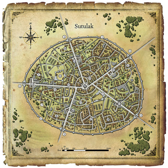
An unencumbered human can walk 300 ft per minute, or hustle 600 ft in the same time, though jogging through the city armed to the teeth (as most PCs are) might attract attention. Try to figure out how long it takes to get from, say, #14 to #18 on the map without giving up. There's no grid of any kind, so you'll have to actually measure the distance. You can't travel in a straight line because of the intervening buildings except along the major highways, so you can either measure it in chunks, or, I guess, use a piece of string or something. Then take your measurement, compare it to the scale and divide it by 300 or 600 to find out how many feet it took to do such a thing, and then…
…realize that this number is actually pretty useless. Even if you go through the above steps (which I can't even bring myself to do for this example, and would absolutely not do during play), it's not a helpful measurement. It doesn't take into account crowds, traffic, getting lost, being accosted by strangers, looking for a street sign that's hidden behind a bush, and all of the things that actually determine how long it takes to get around in a city. So, like every other GM in history, you'll never look twice at the "movement per minute" table, never look at the scale, never look at the map, and just say, "eh, it takes ten minutes."
If that works for you, that's fine; you've read a series of walls of text and won't get much out of it. But if you're like me, you'll always have a nagging feeling that you're giving up.
The map of the region around Neverwinter was created with the express purpose of being used in D&D. It is highly specialized for exactly this purpose. The map of Sutulak here was designed, apparently, to help with the morning commute of Sutulakers. So let's turn the city of Sutulak into the forest of Neverwinter.
We need to figure out the town equivalent of forests, mountains, fields, and highways. Highways are literally highways—broad, relatively straight avenues that cut through cities and connect key destinations (such as a market and a gatehouse). As for plains, forests, and mountains? They map pretty clearly to me as low, medium, and high-density construction. Higher density leads to more confusing, twisty, and narrow roads, as well as denser crowds, making it slower to move through these areas (both because you risk taking the wrong turn, and you'll be delayed by traffic). Low-density is the opposite: the more spread-out the buildings are, the more space there is to move between them, the less people there are doing so in the first place, and the easier it is to see where you're going and take the right streets. If your town has large-scale natural elements, such as forests and hills, they should also be included on the map. Sutulak here is criss-crossed with bizarre inner city walls with limited chokepoint entrances, which should also be included on the map.
Districts
In the fifth article in this series, I argued that D&D towns should be thought of as a small number of named, memorable districts (plus a couple of less-memorable Hufflepuff districts). Each district can have its own distinct flavour, racial makeup, police force, and random encounter table (if you use those), and a memorable name.
Points of Interest
Critical buildings and places should be marked with numbers that correspond to a key somewhere. For the more artistically inclined, you could also pick out these buildings in other ways, such as the Nuremberg tourist map's large silhouettes of major attractions.
Putting it Together
You've stuck with me this far, let's power through to the end. Let's take this useless map of Sutulak and turn it into a cutting-edge game aid, step by step.
1. Give it a grid. You can use a square grid (like a pleb) or a modern, high-tech hex grid. Either is absolutely fine. I just overlaid a hex pattern as a new layer over the original one.
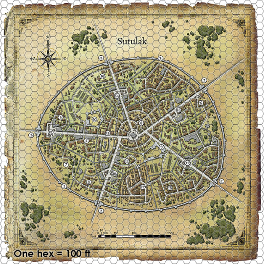
Counting distance is massively easier now. No string or ruler needed; just count the hexes.
2. Highways and Barriers
The various walls and highways criss-crossing the city are important both narratively and mechanically, so let's highlight them, too. Try to keep the number of these small so as to be significant and memorable, don't just connect everything to everything else with a highway, because then we're back at the level of worrying about individual roads.
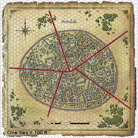
Red lines are highways and allow faster movement; grey lines are walls and prevent movement barring some kind of skill check, spell, etc. Crossing them may also be illegal.
3. Embrace Abstraction
This map still has a bunch of minor streets and buildings confusing the issue. Here's where we're going to embrace full abstraction by removing them outright. Stop seeing the trees, start seeing the forest; there are no buildings or roads, there is only districts and density. Let's get this out of the way first of all: this won't be pretty. With a proper illustration, though, it doesn't need to be.
What I'm going to do is use different fill textures to denote different types of hexes representing district and density. District allocation is more of an art than a science; theoretically I could use every walled-in subdivision as its own district, however, this crazy criss-crossed town has too many of those to be memorable. Instead, I'll combine a few walled-in sections into districts, and in doing so, declare that they have economic, cultural, and ethnic ties to each other. A real artist could do pretty textures in these areas (like the forest texture in the Neverwinter map), but as this is a test case, and I am not a real artist, I don't want to get too bogged down in aesthetics and I'll use simple pattern fills.
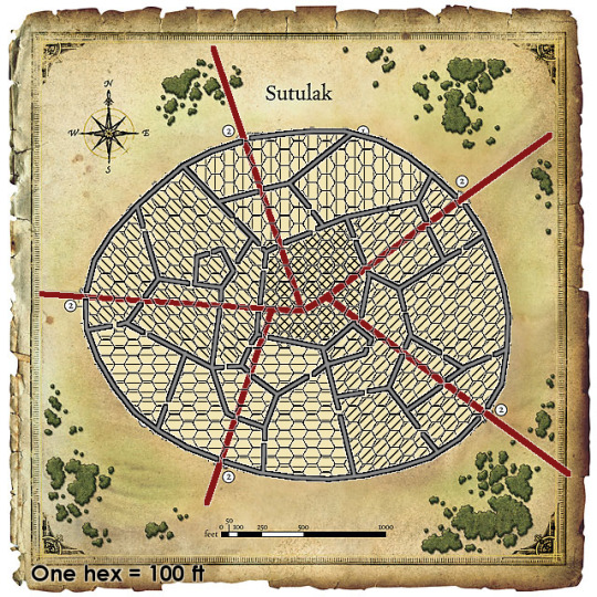
Here's the district map. Different angled lines represent different neighbourhoods. There are five, which I've creatively titled North, East, South, West, and Central. Each district (except central) has at least one gate to the outside world and one highway. I've also moved the walls above the grid layer (making them more visible) and removed the grid outside the city as it was noisy and unnecessary.
Now we can inject building density into the equation. Building density implies population density, which tells us how narrow, twisty, and crowded the streets are, which finally solves our 'movement rate' question.
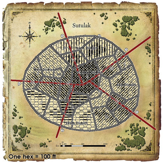
Here we have it: five districts, clearly delineated from each other through textures, and density represented by weight of the lines. Central district there is packed, as befitting a city center, so the entire district is at maximum weight. Because moving through cities has little to do with your physical movement capabilities and more to do with traffic and navigation skill (a Ferrari wouldn't get you through traffic any faster than a Honda), we can largely ignore a character's movement stat and base movement just off of hex density. Maybe we can come back to this, but for the time being, let's say you can move through low density hexes (with little traffic and lots of clear sightlines making for easy navigation) and highways at a rate of 3 hexes per minute, medium density hexes at a rate of 2 per minute, and high-density hexes at a rate of 1 per minute. Highways boost speed not only because they are broad and straight, but also because it is much harder to take a wrong turn on them and have to double back.
If you wanted a coarser grid, you could make each hex 300ft, and say that it took you 1 minute to move through a light density hex, 2 minutes to move through a medium density hex, and 3 minutes to move through a high density hex.
Future Improvements
I also added points of interest numbers in this step. If I were to do it again, I'd make them more distinct, such as using the original map's white circles, or perhaps with stylized building silhouettes, like the Nuremberg tourist map.
Districts can also be denoted using colours, with darkness and lightness indicating density, perhaps given borders like nations on a world map to distinguish them a little more from each other. Gates between walled prefectures are also important enough that maybe we could borrow a little from dungeon maps and give them a bright, visible "door" symbol. Also, the medium and heavy weighted areas are a bit too similar looking for my taste, so improvements could be made there, as well.
Still, I think this is the right direction. I'm going to let this idea percolate for a while, and maybe try it out in a game or two of my own, before tinkering with it too much.
23 notes
·
View notes