Tumgik
#I looked up the height chart for dnd races and you would not believe the spiral I went in realizing just how small Jace is next to Porter
whoblewboobear · 3 months
Text
Editing them together real quick so they have a couple’s portrait like Jawbone & Sandra Lynn 💖🤧
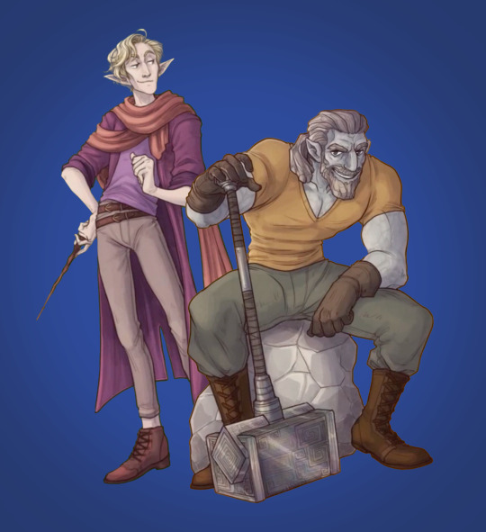
Tumblr media
90 notes · View notes
botwstoriesandsuch · 4 years
Text
OK SHUT UP SHUSH SHUT THE FUCK UP IT’S 1AM BUT SHUSH LISTEN! HEY, LISTEN!
I AM GIVING YOU THE TOOLS TO FIND THE EXACT DISTANCE OF ANYTHING ANYWHERE IN HYRULE, CUSTOM MAKE YOUR FIC JOURNEYS TO THE METER, FIND THE AREA OF ANY TOWN OR LANDMARK, OR JUST FIND OUT HOW BIG (or small) HYRULE KINDGOM TRULY IS ONCE AND FOR ALL SO GO AHEAD AND SAVE THIS POST TO YOUR DRAFTS CAUSE YOU MIGHT WANNA SEE IT FOR FUTURE REFERENCE
 Ok so this all starts with THIS
Tumblr media
FEAST YOUR EYES LADIES, LADS, AND GENTLEFOLK ON THE ONLY PIECE OF INFORMATION IN ALL OF HYRULE CONCERNING DISTANCE AND TIME. 
[Image ID: A screenshot from The Legend of Zelda: Breath of the Wild, depicting a picture of Ash Swamp hanging in Impa’s house. The dialogue box from Impa reads, “Does it look familiar? From this village, you should be able to get there in a half day’s time.” End ID]
Impa states that it would take you half a day, about 12 hours, to travel from Kakariko Village to the depicted 13th memory, which is at Ash Swamp by Fort Hateno. 
Now here is where I took this information. I took it to
objmap.zeldamods.org
A fantastic online Botw map resource with tons of features like finding specific objects, and highlighting areas, and placing pins, and the basics of showing the locations of everything like shrines and korok seeds and all that. 
BUT the thing that we care about today is this ability, here:
Tumblr media
DRAW!
With those widgets on the right, I can specifically mark lines and shapes and the website will give me the distance of it in meters!
“But Kip, if the map already gives you the distance of anything you want then isn’t this entire post pointless?” Ashshshshshhshh no, shut the fuck up, shush shut, no, stop, silence, I am high on caffeine and I haven’t slept for two days. No. 
As great as the map is, the exact ratio isn’t the best. Like, it tells me that the length of Hyrule is only 10km, or 6.2 miles. 
Tumblr media
I wager that realistically, Hyrule would be a bit bigger than that. And THAT, is where I come in. Or, more specifically, Impa.
Impa states that it takes 12 hours to travel from Kakariko to Fort Hateno. (I am saying Fort Hateno and not Ash Swamp because I am going of the nearest prominent landmark location near the 13th memory, and I highly doubt that Impa knew the exactly square foot patch of dirt that Link needed to stand on to activate his memory)
According to Google, it takes around 10 to 12 minutes to walk a kilometer. (I am assuming Impa was referring to walking and not riding, because I feel like she would have said, “You should be able to get there in half a day’s ride” or something of the sort. So, walking it is)
So: 
12 hours divided by 12 minutes 
(Which is 720 minutes / 12 minutes)
gives us
60
The distance between Fort Hateno and Kakariko village is 60 kilometers.
Badabing badaboom, great job! We did it. BUT NOW this is where our handy dandy online object map comes in.
Tumblr media
[Image ID: A screenshot of the Breath of the Wild map showing the area of Kakariko Village and the plains in front of Fort Hateno. A blue line highlghts the path from the village to a marker on Fort Hateno. The line reads “1.89km.” End ID]
Tumblr media
[Image ID: A screenshot of the Breath of the Wild map showing the area of Kakariko Village and the plains in front of Fort Hateno. The blue line from the previous image is still there, however, there is now a more prominent yellow line. The yellow line runs from Kakariko village, but ends at a marker point at the location of the 13th memory at Ash Swamp. The yellow line reads “1.55km.” End ID]
So while this map doesn’t give me distances that are exactly to my liking, it DOES give me a measuring means that will stay consistent. SO! As you can see, the map says Kakariko to Fort Hateno is 1.89km. (And just to be safe, I also did the distance exactly to the point of the 13th memory as shown in Impa’s picture, which came out to 1.55km. But! It’s doesn’t matter anyhow, because) We’re going to round this to 2km for the sake of my sanity because surprise surprise! I actually suck at, and hate, math. 
So the map says Kakariko to Fort Hateno is 2 kilometers, but we know that in real life, the distance is actually 60 kilometers. So, if you want to use this object map effectively, you have to make a means of converting the “false” measurements, (which I will be refering to as “zelda” (kilo)meters, or zm/zkm) from the actual ones. 
So THIS is what I fucking did oh my god help me it took me way too long even though it was really simple in hindsight I was just stupid and spent two hours trying to get the ratio equations right when really all I had to do was divide, it was a whole thing, anyhow, read away. 
Tumblr media
[Image ID: A screenshot of MATH oh my god it’s fucking math...BUT it’s kinda color coded so that’s nice. The top left of the page depicts text. In red text reads “zkm (Zelda km) = per the measurement on the objmap.zeldamods.org” and below that, in black text, reads, “Kakariko to Fort Hateno = 1.89 zkm ~ 2zkm,” which is underlines in yellow. Another line of black text reads, “Impa says it takes half a day’s time to travel from Kakariko to the 13th memory location AKA 12 hours.” Another line of black text reads, “It takes about 10-12min to walk a kilometer,” which is underlines in green.
Handwritten in blue ink is the equation, 
“12 hours = 720 min
720/12 = 60″ 
The 12 is highlighted in green, and the 60 is underlined. In green text, below it, reads, “It takes 12 hours to walk 60 kilometers.” In black text under this, it reads “So Kakariko to Fort Hateno is 60 kilometers.” Another line of black text under this reads, “So based on that, we can find the actual values of a zkm (Zelda kilometer).” 
Handwritten in yellow ink is the equation,
“2zkm = 60km
1km = 30km” [typo, I meant 1zkm = 30km]
The 60km is in blue, and the equation 1zkm = 30km is circled. 
To the right of everything, in bigger, yellow text, reads “So: 1zkm = 30km 1zm = 30 meters
The map of Hyrule measures roughly 10zkm (length) by 8zkm (height) [typo, I meant width] giving it an area of 80 square zkm.
Therefore, the “true” size of Hyrule Kingdom os 2400 square kilometers.” End ID]
SO ARMED WITH THIS NEW KNOWLEDGE, you can now use this map to measure whatever you want, and by converting 1zm to 30 meters, you can get accurate result as to what that distance is. 
Chart the roads, measure the rivers, the map even gives area tools for polygons, squares, and circles! This entire post was born out of a desire to see how long the characters in my fic should rest for when travel between different stables. 
Now before anyone asks, yes! 2400 square kilometers is fairly small. That’s around 930 square miles. I believe even Wales is more than three times bigger than that. BUT! Considering Hyrule is a medieval kingdom that’s actually pretty sizable considering the average size of a Kingdom was 100 to 900 square kilometers. 
And juuuust to double check, I ran the size though a Medievil Demographics generator, and 2400 (under the conditions of Fertile Land with 64% of the land being arable since I figured roughly 46% for lakes, the ocean, plus unusable land was more than enough to cover the Hebra, Death Mountain, and the Gerudo Desert. Which honestly is even MORE generous considering there are races that occupy these areas, but I digress) This still gives Hyrule Kingdom a good population of 108,000 people! Before the Calamity when all of its villages were up and occupied, of course. So the area is definitely more than enough, and can still give Link a more realistic amount of time to travel between areas (when you add eating and rest of course. Don’t make my guy walk for 10 hours straight from the Great Plateau to Hebra D: plz)
TL;DR: Hyrule is 2400 square kilometers; use the map, plus the conversion 1 zelda meter to 30 meters to measure anything you want; I am tired
Quick Edit: Please note that this conversion is for the purposes of people out there who need more realistic means of measuring distances for larger scale travel and such, like for writing fic journeys, or dnd campaigns. This conversion isn’t the best for smaller scale measure like buildings and such (EX: I’ve checked with buildings in Castle Town and the Coliseum, and they come out much too big, just a symptom of game design ratios not being perfect since it’s hard to balance consistent measurements and the immersion and plan a creator has for their game world!) So if you are measuring those smaller entities using the linked map, just stick with the given zelda meters! (EX: The Coliseum radius in zelda meters matches up nicely with the real world Roman Colosseum, beating it out by a few dozen meters!)
Also if you are a true believer in the interpretation of Impa’s dialogue as “half the amount of daylight hours,” see the reblogs!
1K notes · View notes