#Hydrological Study Required
Explore tagged Tumblr posts
Visit Tumblr Blog
Explore Tumblr blogs with no restrictions, modern design and the best experience.
Last Seen Tumblr Blogs


Fun Fact
Tumblr Inc. has $15.1M in annual revenue.
Text
Dhalbhumgarh Airport Project Faces Hurdles as Forest Clearance Returned for Revisions
The Ministry of Environment, Forest and Climate Change requests more details on Dhalbhumgarh Airport’s forest clearance proposal, clarifying the site isn’t within the Elephant Corridor. The Ministry of Environment, Forest and Climate Change (MoEF&CC) has returned the Dhalbhumgarh Airport project’s forest clearance proposal to the Jharkhand government, seeking additional information and…
#compensatory afforestation#Dhalbhumgarh Airport Project#Elephant Corridor Impact#Environmental Impact Assessment#Forest Clearance Delay#human-elephant conflict#Hydrological Study Required#Jharkhand development#MoEF&CC Environmental Review#Singhbhum Elephant Reserve
0 notes
Text
"In response to last year’s record-breaking heat due to El Niño and impacts from climate change, Indigenous Zenù farmers in Colombia are trying to revive the cultivation of traditional climate-resilient seeds and agroecology systems.
One traditional farming system combines farming with fishing: locals fish during the rainy season when water levels are high, and farm during the dry season on the fertile soils left by the receding water.
Locals and ecologists say conflicts over land with surrounding plantation owners, cattle ranchers and mines are also worsening the impacts of the climate crisis.
To protect their land, the Zenù reserve, which is today surrounded by monoculture plantations, was in 2005 declared the first Colombian territory free from GMOs.
...
In the Zenù reserve, issues with the weather, climate or soil are spread by word of mouth between farmers, or on La Positiva 103.0, a community agroecology radio station. And what’s been on every farmer’s mind is last year’s record-breaking heat and droughts. Both of these were charged by the twin impacts of climate change and a newly developing El Niño, a naturally occurring warmer period that last occurred here in 2016, say climate scientists.
Experts from Colombia’s Institute of Hydrology, Meteorology and Environmental Studies say the impacts of El Niño will be felt in Colombia until April 2024, adding to farmers’ concerns. Other scientists forecast June to August may be even hotter than 2023, and the next five years could be the hottest on record. On Jan. 24, President Gustavo Petro said he will declare wildfires a natural disaster, following an increase in forest fires that scientists attribute to the effects of El Niño.
In the face of these changes, Zenù farmers are trying to revive traditional agricultural practices like ancestral seed conservation and a unique agroecology system.

Pictured: Remberto Gil’s house is surrounded by an agroforestry system where turkeys and other animals graze under fruit trees such as maracuyá (Passiflora edulis), papaya (Carica papaya) and banana (Musa acuminata colla). Medicinal herbs like toronjil (Melissa officinalis) and tres bolas (Leonotis nepetifolia), and bushes like ají (Capsicum baccatum), yam and frijol diablito (beans) are part of the undergrowth. Image by Monica Pelliccia for Mongabay.
“Climate change is scary due to the possibility of food scarcity,” says Rodrigo Hernandez, a local authority with the Santa Isabel community. “Our ancestral seeds offer a solution as more resistant to climate change.”
Based on their experience, farmers say their ancestral seed varieties are more resistant to high temperatures compared to the imported varieties and cultivars they currently use. These ancestral varieties have adapted to the region’s ecosystem and require less water, they tell Mongabay. According to a report by local organization Grupo Semillas and development foundation SWISSAID, indigenous corn varieties like blaquito are more resistant to the heat, cariaco tolerates drought easily, and negrito is very resistant to high temperatures.
The Zenù diet still incorporates the traditional diversity of seeds, plant varieties and animals they consume, though they too are threatened by climate change: from fish recipes made from bocachico (Prochilodus magdalenae), and reptiles like the babilla or spectacled caiman (Caiman crocodilus), to different corn varieties to prepare arepas (cornmeal cakes), liquor, cheeses and soups.
“The most important challenge we have now is to save ancient species and involve new generations in ancestral practice,” says Sonia Rocha Marquez, a professor of social sciences at Sinù University in the city of Montería.
...[Despite] land scarcity, Negrete says communities are developing important projects to protect their traditional food systems. Farmers and seed custodians, like Gil, are working with the Association of Organic Agriculture and Livestock Producers (ASPROAL) and their Communitarian Seed House (Casa Comunitaria de Semillas Criollas y Nativas)...

Pictured: Remberto Gil is a seed guardian and farmer who works at the Communitarian Seed House, where the ASPROL association stores 32 seeds of rare or almost extinct species. Image by Monica Pelliccia for Mongabay.
Located near Gil’s house, the seed bank hosts a rainbow of 12 corn varieties, from glistening black to blue to light pink to purple and even white. There are also jars of seeds for local varieties of beans, eggplants, pumpkins and aromatic herbs, some stored in refrigerators. All are ancient varieties shared between local families.
Outside the seed bank is a terrace where chickens and turkeys graze under an agroforestry system for farmers to emulate: local varieties of passion fruit, papaya and banana trees grow above bushes of ají peppers and beans. Traditional medicinal herbs like toronjil or lemon balm (Melissa officinalis) form part of the undergrowth.
Today, 25 families are involved in sharing, storing and commercializing the seeds of 32 rare or almost-extinct varieties.
“When I was a kid, my father brought me to the farm to participate in recovering the land,” says Nilvadys Arrieta, 56, a farmer member of ASPROAL. “Now, I still act with the same collective thinking that moves what we are doing.”
“Working together helps us to save, share more seeds, and sell at fair price [while] avoiding intermediaries and increasing families’ incomes,” Gil says. “Last year, we sold 8 million seeds to organic restaurants in Bogotà and Medellín.”
So far, the 80% of the farmers families living in the Zenù reserve participate in both the agroecology and seed revival projects, he adds."
-via Mongabay, February 6, 2024
#indigenous#ecology#agroforestry#agriculture#traditional food systems#traditional medicine#sustainable agriculture#zenu#indigenous peoples#farming#colombia#indigenous land#traditional knowledge#seeds#corn#sustainability#botany#plant biology#good news#hope#climate action#climate change#climate resilience#agroecology#food sovereignty
1K notes
·
View notes
Text
Yesterday, I posted a summary of the study and report described in this Grist article. We get more details (if we're interested) here. Additionally, to me, the recommendations to proceed more holistically with the numerous global issues dealing with biodiversity and the climate are critically important. I've been repeating this mantra for several years, and will continue to do so. Deal with the environment = solve the climate crisis.
Excerpt from this story from Grist:
As global temperatures rise from the burning of fossil fuels, researchers and policymakers have proposed solutions like installing renewable energy, replacing gasoline-powered cars with electric ones, and developing technology to suck carbon out of the air. But these policies often address climate change in isolation — without regard for other pressing issues like a decline in biodiversity, the contamination of freshwater sources, and the pollution of agricultural soils.
A new report released Tuesday by the United Nations’ expert panel on biodiversity makes the case for a different approach based on addressing the “nexus” between two or more out of five essential issue areas: climate change, biodiversity, food, human health, and water. Such an approach is not only more likely to help the world meet various U.N. targets on biodiversity, sustainable development, and climate mitigation; it’s also more cost-effective.
“We have to move decisions and actions beyond single-issue silos,” said Paula Harrison, a professor of land and water modeling at the U.K. Centre for Ecology and Hydrology and a co-chair of the report, in a statement. Other scientific reports have studied the interlinkages between two or three of these issues, but she told reporters on Tuesday that this latest report is the “most ambitious” to date.
The new report was the result of three years of work of the Intergovernmental Science-Policy Platform on Biodiversity and Ecosystem Services, or IPBES, an expert body that’s analogous to the United Nations’ Intergovernmental Panel on Climate Change, which periodically assesses the state of the science on global warming.
The report centers on biodiversity — that’s the IPBES’s remit, after all — describing how the variety of life on Earth is “essential to our very existence.” But it goes out of its way to show how rapidly accelerating biodiversity loss is both contributing to and being exacerbated by other crises. Climate change, for instance, is making some habitats inhospitable to their erstwhile animal populations, while the loss of those populations can have impacts on freshwater availability and carbon storage. The five interlinking issues were selected by representatives of the 147 IPBES’s member countries.
Meanwhile, solutions that focus on just one issue may have detrimental effects on other elements. Pete Smith, a professor of soils and global change at the University of Aberdeen in the United Kingdom, gave the example of bioenergy with carbon capture and storage, or BECCS, a climate solution in which crops are grown to draw CO2 out of the air and then burned to generate energy. The resulting greenhouse gas emissions are captured and stored in rock formations, with the aim of removing them from the carbon cycle permanently.
The problem, Smith said, is that to implement this process on a large scale would require vast tracts of land that might otherwise have been used to grow food crops — so BECCS can unintentionally harm food security. Devoting land to single-variety crops can also use up lots of water and jeopardize biodiversity.
10 notes
·
View notes
Text
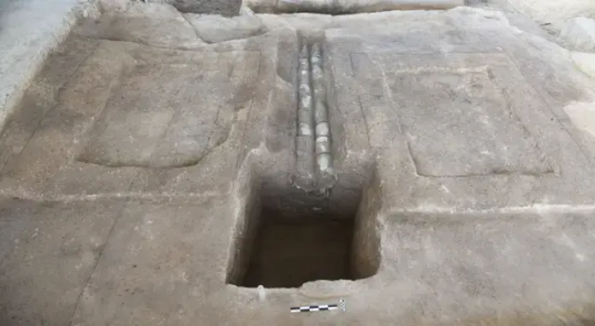
4,000-Year-Old Ceramic Drainage System Discovered in China
The people of Pingliangtai built and operated the system without any help from a central state government.
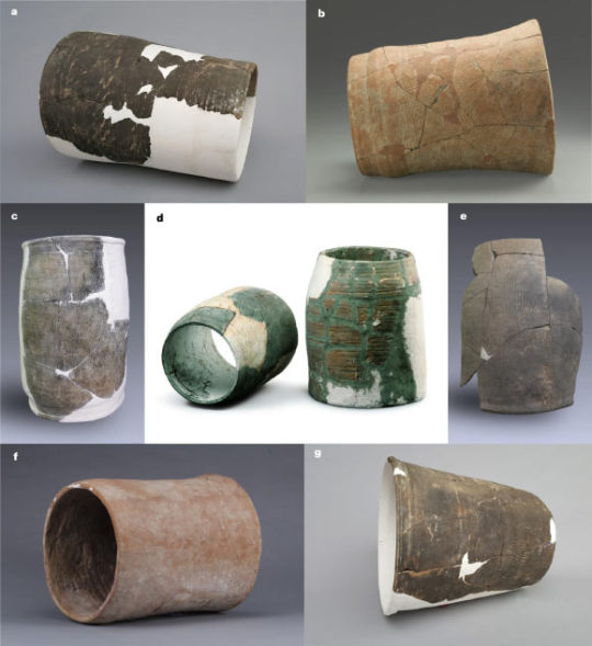
China’s Longshan period which lasted from about 2600 to 2000 BCE is best known for its sophisticated pottery shapes, but their sophisticated plumbing is getting some well-deserved attention. A team of archaeologists found the oldest known ceramic water pipes in China, demonstrating that locals were capable of major feats of engineering without a centralized state government. The findings are described in a study published August 14 in the journal Nature Water.
The newly unearthed network of ceramic water pipes and drainage ditches were found at the ancient walled city of Pingliangtai, located in what is now the Huaiyang District of Zhoukou City in central China. The town was home to roughly 500 people during neolithic times and had protective walls and a surrounding moat. It sits on the Upper Huai River Plain on the vast Huanghuaihai Plain, and the climate 4,000 years ago saw large seasonal climate shifts. Summer monsoons could dump a foot and a half of rain on the region every month.

With all this rain, it was critical for the region to manage floodwaters. The people of Pingliangtai appear to have built and operated a two-tier drainage system to help mitigate the rainy season’s excessive rainfall. Simple but coordinated lines of drainage ditches ran parallel to the rows of houses to divert water from the residential area to a series of ceramic water pipes that carried the water into the surrounding moat, and away from the village.
The team says that this network of pipes shows that the community cooperated with one another to build and maintain this drainage system.
“The discovery of this ceramic water pipe network is remarkable because the people of Pingliangtai were able to build and maintain this advanced water management system with stone age tools and without the organization of a central power structure,” study co-author and University College London archaeologist Yijie Zhuang said in a statement. “This system would have required a significant level of community-wide planning and coordination, and it was all done communally.”
The network is made of interconnecting individual segments which run along roads and walls that divert rainwater. According to the team, it shows an advanced level of central planning and is the oldest complete system discovered in China to date.


The team was also surprised by this find because the Pingliangtai settlement shows little evidence of a social hierarchy. The homes within it were uniformly small and there aren’t any signs of social stratification or significant inequality amongst the population. Digs at the town’s cemetery also didn’t reveal any evidence of a social hierarchy in burials the way excavations at other nearby towns have.
The level of complexity that these pipes demonstrate also undermines some earlier understanding of archaeological finds that believe only a centralized state power could organize and provide the resources for such a complex water management system. Other ancient societies that used advanced water systems tended to have a stronger, more centralized government, but Pingliangtai shows that that centralized power was possibly not always needed.
“Pingliangtai is an extraordinary site. The network of water pipes shows an advanced understanding of engineering and hydrology that was previously only thought possible in more hierarchical societies,” study co-author and Peking University archaeologist Hai Zhang said in a statement.
The ceramic water pipes also show an advanced level of technology for this period in time. Like with Longshan pottery, there was some variety of decoration and styles, but each pipe segment was about 7.8 and 11.8 inches in diameter and about 11.8 to 15.7 inches long. Multiple segments were slotted into one another to transport the water over long distances.
According to the study, the team can’t say specifically how the labor to build this infrastructure was organized and divided. A similar level of communal coordination would also have been necessary to build the earthen walls and moat that surround Pingliangtai.
By Laura Baisas.
#4000-Year-Old Ceramic Drainage System Discovered in China#ancient city of Pingliangtai#Zhoukou City#ancient artifacts#archeology#archeolgst#history#history news#ancient history#ancient culture#ancient civilizations#ancient china#chinese history
36 notes
·
View notes
Text
Unit 5 Blog Post: Citizen Science and Conservation Practices
Happy thanksgiving everyone!
Given that this week’s blog prompt is open, I wanted to share some thoughts inspired by our course content so far.
While watching Washington Wachira’s TED Talk "For the Love of Birds," I began reflecting on the role of citizen science. Apps like iNaturalist, which is widely used in Guelph, offer a powerful tool to connect people with nature by allowing users to log observations. However, they also inadvertently filter participation.
For instance, I’ve spoken with older individuals who possess immense knowledge of local flora and fauna but do not engage with these apps. Their insights are invaluable, yet their observations remain undocumented in digital platforms. This raises a concern: Are we excluding certain demographics from contributing to citizen science simply because of a technological barrier?
This issue highlights the need to design more inclusive citizen science initiatives. If older generations or non-tech-savvy individuals struggle to access these platforms, we may miss crucial knowledge. Digital platforms should be complemented with physical or analog extensions—perhaps logbooks or community-led observation notebooks that can be collected and digitized by volunteers.
During my time in Kenya, I witnessed how citizens live in harmony with their natural environment. Kenya’s incredible biodiversity, which spans savannahs, tropical forests, deserts, and highlands, surpasses that of Canada. Yet, despite this richness, much of the local knowledge remains undocumented in apps or digital tools. Conservation in Kenya requires more than just technological solutions—it depends on community engagement and biocultural conservation. One of my professors, Carol Muriuki, a conservationist with the National Environment Management Authority (NEMA), shared insights that transformed my understanding of conservation. She emphasized that conservation cannot follow a “one-size-fits-all” approach. Community stewardship and biocultural conservation is crucial for designing conservation initiatives that have a lasting positive impact. Instead of crafting a conservation plan that looks good on paper but is not feasible in the real world. Each initiative must account for ecological, economic, and cultural realities.
A compelling example is the Lake Naivasha region, where rising water levels—likely caused by climate change—are displacing communities that rely on the lake for food and income. As Carol explained, simply forcing people to relocate isn’t a viable solution. Instead, NEMA is working on a more holistic approach, such as restructuring hydrological infrastructure, planting mangrove trees, and compensating displaced families. This approach integrates the needs of both people and the environment, exemplifying how inclusive conservation practices can lead to sustainable outcomes.

Figure 1. Blurry view of Lake Naivasha from the campground in Kenya (Griffiths, 2024)
I see Carol’s work as a model for future conservation efforts, where citizen science plays a central role in shaping projects rather than just being a tool for data collection. For citizen science to be effective, it must evolve beyond passive contributions. It should foster continuous dialogue between scientists and the public, ensuring citizens actively participate in research and conservation initiatives. This approach could help address the issue of bias in scientific sampling. Scientists often focus on charismatic species—those that are easy to observe or already have a wealth of knowledge available from past studies. As opposed to cryptic or under-studied species. In contrast, citizen observations tend to be more exploratory, as participants are not constrained by preconceptions about which species are significant, enriching scientific understanding in unexpected ways.
One of the biggest takeaways from this course is the realization that academic science offers only a narrow lens through which to engage with nature. As students, it’s easy to become trapped within the confines of scientific rigor and overlook the many other ways people connect with the natural world. Yet, through this course, I’ve learned that storytelling, art, and lived experiences are equally powerful tools for interpreting the environment. For example, conservation is as much about understanding community needs as it is about protecting ecosystems. Similarly, citizen science is not just about data—it’s about fostering a deeper relationship between people and nature.
Ultimately, effective conservation requires both emotional and intellectual engagement. Successful initiatives depend on integrating scientific knowledge with community stewardship. Similarly, citizen science can only reach its full potential when it invites participation from all walks of life—from scientists, to tech-savvy citizens, and those more comfortable with traditional forms of engagement. As I reflect on what we’ve covered so far, I believe we are just beginning to scratch the surface of how we can engage an audience with nature. The challenge lies in finding new ways to connect with both people and the environment—whether through technology, community dialogue, or personal storytelling.
2 notes
·
View notes
Text
Sustainable Natural Resource Management: Forests, Woodlands, and Wetlands

Abstract
Forest and wetlands are fragile communities, when human activities precede uncontrolled their roles are lost. Objective was to investigate the role of forest and wetlands as water catchment areas in Zimbabwe. Christmas Pass forest woodland and wetland in Mutare was the study site. Sample of 196 people, selected through stratified random sampling and simple random sampling, then purposive sampling for 20 key informants. In-depth interview, key informant interviews, focus group discussion, and observation was conducted. Study revealed that both forest and wetlands are important in the hydrological cycle. Noted that there are several adverse impacts brought by anthropogenic activities. Observed that water was an essential factor in sustainable forest management, and forests are crucial for regulating the water cycle. Forest woodlands and wetlands are under a huge threat for extinction, as anthropogenic activities continue to impact negatively on these areas. Forest woodlands and wetlands are a major water catchment area and there is need for catchment basin management plan for as to rejuvenate the river flow downstream. Recommended the need for best management practices (BMPs) as they are proactive and often voluntary practical methods or practices used during forest management to achieve goals related to water quality, silviculture, wildlife and biodiversity, aesthetics, and/or recreation. Noted that the sustainable management of the forest woodlands requires participatory approach of all stakeholders through capacity building and empowerment. Above all, there was need for the catchment basin to balance its role of provision of human needs and the ecosystem services.

Introduction
The deforestation involves conversion of forest land to agriculture land, or residential resettlement. Worldwide the most concentrated deforestation occurs in tropical rainforests. About 31% of Earth's land surface is covered by forests. Between 15 million to 18 million hectares of forest, an area the size of Belgium, are destroyed every year, on average 2,400 trees are cut down each minute (IUFRO, 2007). FAO (2013) indicated that only 4 billion hectares of forest are left. The world has lost one-third of its forest, an area twice the size of the United States. This is despite the fact that forest and wetland are major catchment area for water, which need to be used by the human beings.

The above degradation of the wetland and forest has significantly affected the hydrological cycle. FAO (2013) suggested that water is a scarce commodity as it availability, accessibility, adequate and safety heavily depends on climate conditions, weather and sustainable management of the water catchment basins. The first and key step in providing safe water is the selection of the best available sources of water. The best sources of safe water is found in well protected catchment area that includes forest woodlands and wetlands. In general ground water is better protected water that the surface water, the ground water is usually found in the forest or wetlands as springs (Bonan, 2008).Catchment protection is the second step in providing safe water and where, for whatever reason, source choice is limited it presents a key opportunity to minimise pathogen contamination. A catchment is an area where water is collected by the natural landscape. Imagine cupping a person’s hands in a downpour of rain and collecting water in them (FAO, 2013). The forest woodlands and wetlands are a very important water catchment basin. In most parts of Zimbabwe, it is being evident that the management of water catchment basin depends largely on the institutional setting as well as policy orientation of different communities.

Naturally, human beings, animals, birds and forests depend largely on each other and without proper management systems human beings will overrule the natural communities. This naturally creates tension between natural resources, including woodlands, wetlands, animals and birds since the demand and the need for these natural resources will increase (FAO, 2013). This has led to degradation of the forest woodlands and the wetlands. Wetlands and forest woodlands are fragile communities and when human activities precede uncontrolled, function and roles of the wetland and forest woodland as a water catchment source and species richness will be lost. According to Bredemeier (2002), anthropogenic activities affect the health of our water catchments this is through deforestation of the forest woodlands, and settlement and farming in the wetlands just to mention a few.
Humans often equate forest and wetlands with wasteland, a place to be drained, filled in, burnt off and re-purposed. In fact, FAO (2013) studies show that 64% of the world’s wetlands have disappeared since 1900. Measured against 1700, an estimated 87% have been lost. There has been serious deforestation, clearance, clearcutting, or clearing is the removal of a forest or stand of trees the Christmas Pass forest woodland and wetland that is then converted to non-forest use.

Water has become a scarce commodity in the study area as the water catchment areas are drying up. FAO (2013) indicated that the forest woodlands and wetlands are being cleared for the purpose of timber harvesting, resettlement and farming. Therefore the study area is not spared, this has led to woodlands and wetlands around the study area losing their original status of being a water catchment basin, loss of flora and fauna species used to be seen in the forest and wetland area as there is no water to drinking. The rivers network are dried up and no water is flowing downstream. This then means that Zimbabwe has not been spared, from the adverse impacts of land degradation desertification, and drought. FAO (2013) indicated that it is estimated that 10% of land’ soils are under high risk of erosion due to the nature of soils, which are sodic. The soils break into fine particles and tunnel subsequently collapsing and forming gullies (FAO, 2013). Some of the reason for land degradation especially taking the form of desertification, deforestation, overgrazing, salinization, or soil erosion, land degradation can be caused by unsustainable land management practices, such as deforestation, soil nutrient mining and biophysical factors, such as the natural topography of an area or its rainfall, wind, and temperature.
Source : Sustainable Natural Resource Management: Forests, Woodlands, and Wetlands | InformatoveBD
2 notes
·
View notes
Text
Brazil’s Cerrado, the second largest biome after the Amazon, could lose almost 34% of its water by 2050

The Cerrado, a vast tropical savanna in Brazil and the country’s second largest biome after the Amazon rainforest, could lose 33.9% of its river flows by 2050, if the pace of agricultural exploitation remains at current levels. This volume of water corresponds to the flow of eight Nile rivers in Egypt.
The Cerrado occupies 22% of the Brazilian territory, in the center-east region, including the capital Brasília. The alert was made by Instituto Cerrados (Cerrados Institute), an NGO that works to protect the environment. They analyzed 81 river basins in the region, between 1985 and 2022, and discovered that there was a decrease in flow by 88% due to the growth of agriculture.
The study indicates that the cultivation of soybeans, corn and cotton, as well as livestock, have influenced the water cycle of the Cerrado. Also, according to the study, changes in land use resulting from deforestation caused a reduction in water flow in 56% of cases. The other 44% is associated with climate change.
“Deforestation for large-scale agriculture, which requires intense irrigation, changes the hydrological cycle in a way that reduces the flow of rivers,” said the founder and director of Cerrados Institute, Yuri Botelho Salmona.
Continue reading.
#brazil#politics#brazilian politics#environmentalism#cerrado#mod nise da silveira#image description in alt
14 notes
·
View notes
Text
Why Choose Rocky Mountain Environmental Associates, Inc. for Idaho Green Solutions

When it comes to preserving Idaho’s environment, you need a dependable partner. Rocky Mountain Environmental Associates, Inc. offers exceptional Idaho environmental services, assisting businesses, landowners, and communities in staying compliant and eco-friendly. With years of expertise, our knowledgeable environmental team in Idaho delivers customized strategies for hydrologic, environmental, and water rights challenges.
Expert Environmental Team in Idaho
Selecting the right environmental firm is crucial. At Rocky Mountain Environmental Associates, Inc., our team consists of highly skilled professionals who understand Idaho’s unique ecological challenges. We stay informed on regional regulations and industry best practices to ensure accurate assessments and solutions. Whether you need site evaluations, regulatory support, or resource management, our specialists are here to assist.
Comprehensive Hydrologic Services in Idaho
Water is among Idaho’s most valuable resources. Our hydrologic services in Idaho support businesses, government agencies, and individuals in managing water responsibly. We offer groundwater studies, surface water analysis, and floodplain assessments to promote sustainable water use. Our experts utilize advanced technology and data-driven insights to provide actionable recommendations.
Why Hydrologic Services Matter
Protect water quality – Ensure access to clean and safe water.
Encourage responsible use – Prevent overuse and depletion of vital water sources.
Support development projects – Identify potential risks before construction begins.
With our expertise, you can manage water resources efficiently while complying with state laws.
Reliable Water Right Services in Idaho
Water rights are essential for landowners, farmers, and businesses in Idaho. Understanding water rights regulations can be complex, but our team simplifies the process. Our water right services in Idaho include:
Water right applications – Secure legal permissions for new water use.
Transfers and modifications – Adapt existing rights to meet your needs.
Water right assessments – Verify the validity and feasibility of water rights.
Regulatory compliance – Ensure adherence to state and federal regulations.
Our professionals provide clear guidance and manage the paperwork, so you can focus on your operations without legal concerns.
Environmental Assessments and Compliance Assistance
Meeting environmental regulations is essential for any business or development project. Our Idaho environmental services include in-depth environmental site assessments, permitting support, and remediation planning. We help detect potential environmental risks early, allowing you to take proactive steps to address them.
Why Environmental Compliance Matters
Avoid costly fines – Stay within legal requirements and prevent penalties.
Improve sustainability – Reduce environmental impact and optimize resource use.
Increase property value – Environmentally compliant properties attract buyers and investors.
Our team works closely with clients to develop effective, long-term solutions that align with environmental regulations and industry standards.
Customized Solutions for Every Project
Each project has distinct needs, so we tailor our services to align with your objectives. Whether you need ongoing environmental monitoring, hydrologic analysis, or water rights guidance, we craft a strategy that fits your requirements. Our hands-on approach ensures high-quality support from start to finish.
Why Choose Rocky Mountain Environmental Associates, Inc.?
Clients trust us because we prioritize accuracy, efficiency, and customer satisfaction. We take the time to understand your needs and provide practical solutions. Our standing as a top provider of Idaho environmental services is built on our commitment to excellence.
What Sets Us Apart?
Experienced professionals – Our team has deep expertise in Idaho’s environmental regulations.
Advanced technology – We utilize cutting-edge tools for precise assessments.
Client-focused approach – We work closely with you to achieve the best outcomes.
Proven results – Our successful projects demonstrate our capabilities.
Contact Us Today
If you’re looking for expert Idaho environmental services, trust Rocky Mountain Environmental Associates, Inc. Whether you need hydrologic services in Idaho, water right services in Idaho, or environmental compliance support, we’re ready to assist.
Get in touch today to discuss your project with an experienced environmental team in Idaho!
0 notes
Text
Elevate Your SSC JE Preparation with Nimbus Learning Ultimate Online Platform
Competition to get hired in the government sector in the field of engineering is fiercest ever. If you are aspirer of SSC JE (Staff Selection Commission Junior Engineer) examination then you must utilize best resources and guidance to crown the top ranks. If you are an SSC JE aspirant then Nimbus Learning from Engineers Academy provides complete online coaching services that will help you achieve your desired dreams by providing the structured courses, expert faculties and the result oriented strategies.

Why Choose Nimbus Learning for SSC JE Online Coaching?
For SSC JE online tutoring in all three major engineering branches—mechanical, civil, and electrical—Nimbus Learning is the go-to brand among engineering candidates. Our comprehensive study materials, well-organized classes, and live question-answer sessions make learning efficient and goal-oriented. This is what makes Nimbus Learning unique:
Expert Faculty from Engineers Academy
Our SSC JE online coaching is led by experienced educators and industry experts with years of experience in teaching and mentoring students. The faculty ensures that students grasp fundamental concepts and apply them effectively to solve complex problems.
Comprehensive Study Material
We provide meticulously curated study materials covering the entire syllabus for SSC JE Electrical online classes, SSC JE Mechanical online classes, and SSC JE Civil coaching. The study material is designed to align with the latest exam pattern and syllabus prescribed by the Staff Selection Commission.
Live Interactive Classes & Video Lectures
For SSC JE candidates, Nimbus Learning provides live online courses that allow them to study from home. Students can ask questions and get answers in real time during our live interactive sessions. We also offer lectures on video that have been recorded so that students can review the material at their own leisure.
Subject-Wise & Topic-Wise Test Series
To ensure thorough preparation, we offer regular topic-wise and full-length mock tests that simulate real exam conditions. Our test series is crucial for time management, accuracy, and gaining confidence before the final exam.
Doubt Resolution & Mentorship Support
We provide dedicated doubt-solving sessions where students can interact with expert mentors to clarify complex concepts. One-on-one mentorship ensures that every student receives personalized guidance and motivation throughout their preparation journey.
Affordable & Flexible Learning Plans
Quality education should be accessible to everyone. Our SSC JE Electrical online coaching, SSC JE Mechanical online classes, and best coaching for SSC JE Civil are priced affordably, making quality learning accessible to every aspirant.
Course Offerings for SSC JE Online Coaching
SSC JE Electrical Online Classes
Our SSC JE Electrical online classes cover all essential topics, including:
Circuit Theory
Power Systems
Electrical Machines
Control Systems
Measurements & Instrumentation
Basic Electronics
Network Analysis
Power Electronics
Students will benefit from structured courses, practical problem-solving approaches, and mock tests that mimic actual SSC JE exam patterns.
SSC JE Mechanical Online Classes
Nimbus Learning offers specialized SSC JE Mechanical online classes, focusing on:
Thermodynamics
Strength of Materials
Engineering Mechanics
Fluid Mechanics
Manufacturing Engineering
Heat Transfer
Theory of Machines
IC Engines
With our detailed syllabus, students can master every subject required to excel in the SSC JE Mechanical Engineering exam.
Best Coaching for SSC JE Civil
For civil engineering aspirants, we provide the best coaching for SSC JE Civil, covering:
Building Materials
Structural Analysis
RCC & Steel Structures
Surveying & Geology
Transportation Engineering
Soil Mechanics & Foundation Engineering
Environmental Engineering
Hydraulics & Hydrology
Our systematic approach ensures that students understand fundamental concepts and their real-world applications, making them exam-ready.
Advantages of SSC JE Online Coaching at Nimbus Learning
Course materials follow the newest SSC JE learning targets as well as examination specifications.
The online system conducts ongoing performance assessments through combined quizzes and mock tests with each session and examination.
The educational platform offers students access to experienced faculty members who bring success to every session.
Interacting with mentors and peers creates an environment that strengthens comprehension along with peer support.
Success Stories of Our SSC JE Aspirants
One must be aware that our students have cracked the SSC JE Electrical, Civil, and Mechanical Engineering exams with good ranks many times.
Conclusion
Join SSC JE Online Coaching Now! If you plan on getting into the government job sector, Junior Engineer, Nimbus Learning from Engineers Academy opens the door for you. Don’t miss the opportunity! Register now with SSC JE Electrical online classes, SSC JE Mechanical online classes and top coaching for SSC JE Civil at Nimbus Learning! Come to our website, start from the bottom and build your SSC JE journey with Nimbus Learning!
#ssc je electrical online classes#ssc je electrical online coaching#best coaching for ssc je civil#ssc je mechanical online classes
0 notes
Text
Understanding Land Capability Assessment Cost and LCA Services
When planning a new development or property investment, one of the most critical steps is assessing the land's suitability for your intended purpose. This is where LCA Services (Land Capability Assessment Services) come in. They help determine if a piece of land is suitable for residential, commercial, agricultural, or industrial use. But before diving into the process, it's essential to understand the Land Capability Assessment Cost and how to manage it efficiently.

What is a Land Capability Assessment (LCA)?
A Land Capability Assessment (LCA) is a detailed evaluation of a piece of land to determine its suitability for a specific use. It involves analyzing several factors, including:
Soil Type and Quality: To assess its drainage capability, nutrient levels, and stability.
Topography and Slope: To evaluate erosion risks and construction feasibility.
Water Table and Hydrology: To identify potential flooding issues and wastewater management needs.
Vegetation and Ecology: To understand the environmental impact and sustainability.
This comprehensive assessment ensures that the land can safely support the proposed development while minimizing environmental impacts.
Why is Land Capability Assessment Important?
Regulatory Compliance: Most local councils and environmental agencies require an LCA before issuing development permits.
Environmental Protection: It helps protect natural habitats, water sources, and soil integrity.
Informed Decision Making: Developers and investors can make better decisions about land use and construction plans.
Cost Efficiency: Identifying potential issues early helps avoid costly mistakes during the construction phase.
Whether you’re planning to build a residential community, a commercial complex, or an agricultural project, a Land Capability Assessment is a critical first step.
What Do LCA Services Include?
LCA Services are conducted by professional environmental consultants or geotechnical engineers. These services typically include:
Site Analysis: A detailed examination of the land's physical and environmental characteristics.
Soil Testing: Laboratory analysis to assess composition, drainage, and load-bearing capacity.
Hydrological Study: Evaluating the water table, drainage patterns, and flood risks.
Slope Stability Analysis: Determining the safety of constructing on sloped terrains.
Erosion and Sediment Control Planning: Developing strategies to minimize soil erosion.
Wastewater Management Assessment: Ensuring the land can support septic systems or other wastewater solutions.
Detailed Report Preparation: Compiling all findings into a comprehensive report for regulatory submission.
These services ensure that your project complies with local regulations while optimizing land use and sustainability.
Factors Affecting Land Capability Assessment Cost
Understanding the Land Capability Assessment cost is crucial for effective budget planning. Several factors influence the overall cost, including:
1. Size and Complexity of the Site
Larger Sites: Require more extensive soil testing, site inspections, and detailed reporting, which increases the cost.
Complex Terrains: Sites with varied topography or environmental constraints need more in-depth analysis.
2. Type of Development
Residential Projects: Typically require basic soil and hydrology testing.
Commercial or Industrial Projects: May require more comprehensive environmental impact studies and waste management solutions.
3. Location and Accessibility
Remote Locations: May involve higher transportation and logistical costs for site inspections and soil sampling.
High-Risk Areas: Areas prone to flooding, landslides, or other environmental risks require additional testing.
4. Regulatory Requirements
Local Council Regulations: Some regions have stricter requirements, leading to more detailed assessments and higher costs.
Environmental Sensitivity: Developing near protected habitats or water sources requires more complex evaluations.
5. Consultant Expertise and Fees
Experienced Consultants: Charge higher fees due to their expertise, advanced testing methods, and regulatory knowledge.
Comprehensive Services: End-to-end services, from site analysis to report submission, also add to the cost.
Average Land Capability Assessment Cost
The Land Capability Assessment cost can vary significantly depending on the above factors. On average:
Basic Residential LCA: Costs between $2,000 and $5,000.
Commercial or Industrial LCA: Typically ranges from $5,000 to $15,000 or more, depending on complexity.
Specialized Environmental Impact Studies: Can exceed $20,000, particularly for ecologically sensitive areas.
It’s important to get multiple quotes from LCA service providers to understand the specific costs for your project.
How to Manage Land Capability Assessment Cost Efficiently
Plan Early: Start the LCA process during the early stages of planning to avoid delays and unexpected expenses.
Choose the Right LCA Services: Select experienced consultants with local regulatory knowledge.
Clearly Define the Scope: Communicate your project’s requirements clearly to avoid unnecessary testing and expenses.
Negotiate Fees: Request package deals or discounts, especially for large or multiple assessments.
Budget for Contingencies: Allocate an additional 10-20% of the estimated cost to cover unforeseen issues or additional requirements.
Benefits of Professional LCA Services
Investing in professional LCA Services offers several advantages, including:
Accurate Data Collection: Ensures reliable and accurate data for informed decision-making.
Regulatory Compliance: Helps secure necessary permits and approvals efficiently.
Environmental Protection: Promotes sustainable land use while minimizing ecological impact.
Cost Savings: Identifies potential challenges early, preventing costly changes during construction.
These benefits emphasize the value of hiring experienced professionals for your Land Capability Assessment needs.
Choosing the Right LCA Service Provider
When selecting a provider for LCA Services, consider the following:
Experience and Qualifications: Choose certified environmental consultants or geotechnical engineers.
Local Knowledge: Providers familiar with local regulations can navigate the approval process more efficiently.
Comprehensive Services: Opt for firms offering end-to-end services, from site analysis to report submission.
Client Reviews and Testimonials: Check online reviews and request client references to gauge service quality and reliability.
Choosing the right provider ensures accurate assessments, regulatory compliance, and efficient project execution.
Conclusion: Making Informed Decisions with LCA Services
Understanding the Land Capability Assessment cost and investing in professional LCA Services are essential steps in property development. These assessments provide valuable insights into land suitability, environmental impact, and regulatory compliance, helping you make informed decisions while optimizing your budget.
By planning early, selecting the right consultant, and managing costs efficiently, you can navigate the complexities of Land Capability Assessments and achieve successful, sustainable development projects.
Get Started with Your Land Capability Assessment Today!
Are you planning a development project and need reliable LCA Services? Start by researching local providers and comparing quotes to find the best fit for your needs. With accurate assessments and strategic cost management, you can bring your development vision to life efficiently and sustainably.
With the right approach, you can navigate the complexities of Land Capability Assessment cost and bring your development vision to life.
0 notes
Text

Water Resources Assignment Help: Expert Assistance for Academic Success
Water is probably one of the most significant sources of natural resources identified and used on Earth. It is very essential for life, agriculture, and industries, as well as to the environment at large. Detailed study of water resources reveals its availability, management, conservation, and sustainable use. Most students of environmental sciences, geography, and civil engineers are always given homework about water resources. These can be very complex and involve extensive research, analysis, and problem-solving skills. This is the reason why The Tutors Help has guidelines on how to make assignments related to your water resources projects more manageable and successful.
What Are Water Resources?
Water resources generally are all available sources of fresh water that enhance the use in humans and conservation of ecosystems. They include ground surface water rivers, lakes and reservoirs These water sources enable human consumption but also provide some irrigation besides any hydroelectricity generation.
Aquifer ground-water is the buried water resource mainly supplying drinking supply and agricultural purpose.
Rain falling as it arrives or collected before using for use by households through irrigation.
Desalinated Water: Water extracted from desalination of salt from seawater, in areas that face this problem.
Water resource management is vital not to experience scarcity shortage, pollution, and environmental degradation.
Water Resources Assignment Challenges for the Students
Research Complexity: It becomes complicated to research well about water availability, usage, and conservation methods
Scientific Analysis: Hydrological cycles, how water is polluted, and treatment can be uninteresting.
Statistical Data Interpretation: Most assignments require the interpretation of water consumption data and its effects on the environment.
Time-Consuming Activities: The balance of assignments and other coursework tasks burdens students.
Why Choose The Tutors Help for Water Resources Assignment Support?
The Tutors Help is professional support to help students successfully complete their water resources assignments. Here's why we are your go-to experts:
Expert Tutors: Our team has environmental scientists, geographers, and civil engineers with deep knowledge of water resources.
Customized Assignment: We come up with the most researched assignments, structured precisely according to academic needs.
100% Plagiarism Free Content: This is 100% original, as per our academic integrity. We explain simple concepts in more detail so you understand the concept better.
Time Bound Delivery: We ensure we complete your assignment well before deadlines.
Affordable Services: Our cost is student-effective. So, the excellent service is attainable for everybody.
How to Acquire Water Resources Assignment Help from The Tutors Help
Acquire aid to your assignment instantaneously:
Describe to us about the subject matter, the need and also deadline
We will quote the budget friendly amount of charge to our service
Our professionals shall work upon the assignment appropriately as well as of good quality
You can accept the done assignment, assess use for gaining insight along with boost your grade scores
Last Thoughts
Management of water resources is something that is discussed in our regular life and daily surroundings. This is a most important topic and, if assignments or studies aren't guided from the right resources, it could be really hectic to complete and submit them without any mistakes or errors. Then comes The Tutors Help that guides you how to achieve excellence in your education.
Don't let complex assignment overwhelm you, contact The Tutors Help immediately to get excellent water resources assignment help!
0 notes
Text
A Comprehensive Analysis of the SSC JE Exam Syllabus
Introduction to SSC JE Examination
A route to esteemed engineering positions in government agencies is the Staff Selection Commission Junior Engineer (SSC JE) test. This test evaluates a candidate's technical proficiency and general aptitude and is intended for civil, electrical, and mechanical engineers. The first step to success is comprehending the syllabus. In order to help candidates succeed, this handbook offers a thorough breakdown.
Overview of SSC JE
The SSC JE exam consists of two papers:
Paper 1: Computer-based, covering General Intelligence and Reasoning, General Awareness, and Engineering-specific topics.
Paper 2: Written, focusing on engineering discipline specifics.
Importance of Understanding the Syllabus
A thorough comprehension of the curriculum guarantees targeted preparation, minimizes time waste, and optimizes scoring opportunities. Candidates can use it to prioritize topics according to their abilities and discover important areas.
Exam Patterns
The SSC JE exam pattern includes:
Paper 1: 200 marks (General Intelligence & Reasoning, General Awareness, and Engineering Discipline).
Paper 2: 300 marks (Engineering-specific written exam).
Total Time: 2 hours for each paper.
General Intelligence and Reasoning Syllabus
This section tests logical reasoning and problem-solving skills.
Key Topics Covered
Analogies and Similarities
Spatial Orientation
Visual Memory
Arithmetical Reasoning
Coding and Decoding
Syllogism
Tips for Mastering Logical Reasoning
Practice puzzles daily.
Focus on weak areas using targeted practice.
Use reasoning books like R.S. Aggarwal's "A Modern Approach to Verbal & Non-Verbal Reasoning."
Recommended Resources
Online reasoning quizzes
SSC-specific preparation apps
General Awareness Syllabus
This section evaluates a candidate's knowledge of current affairs and static GK.
Static General Knowledge
History and Geography
Indian Polity and Constitution
Economy and Development
Current Affairs
National and International News
Science and Technology Developments
Sports and Awards
Environmental Studies Overview
Topics like biodiversity, climate change, and sustainable development are often included.
SSC JE Civil Engineering Syllabus
Civil engineering is a major discipline in SSC JE.
Structural Engineering Topics
Theory of Structures
RCC Design
Steel Design
Hydraulics and Water Resources Engineering
Fluid Mechanics
Hydrology
Irrigation Systems
Soil Mechanics
Soil Properties
Compaction and Consolidation
Bearing Capacity
SSC JE Electrical Engineering Syllabus
Electrical engineering covers both theoretical and practical aspects.
Basic Electrical Engineering Concepts
DC and AC Circuits
Electrical Machines
Circuit Theory
Power Systems
Transmission and Distribution
Power Generation Methods
Protective Relays
Electronics and Communication
Basics of Semiconductor Devices
Digital Electronics
Microprocessors
SSC JE Mechanical Engineering Syllabus
Mechanical engineering topics require a strong grasp of core concepts.
Thermodynamics
Laws of Thermodynamics
IC Engines
Refrigeration and Air Conditioning
Manufacturing Processes
Casting and Forging
Metal Cutting
Welding Techniques
Machine Design
Design of Gears
Shafts and Bearings
Mechanical Vibrations
Exam Preparation Tips for SSC JE
Preparation requires a systematic approach.
Creating a Study Plan
Allocate time based on topic weightage.
Include breaks to avoid burnout.
Time Management Strategies
Prioritize difficult topics.
Use timers during practice sessions.
Practice Through Mock Tests
Mock tests simulate exam conditions and help identify weaknesses.
Subject-Wise Weightage in SSC JE Examination
Knowing the weightage helps in prioritizing topics.
Civil Engineering Weightage
Structural Analysis: 25%
Hydraulics: 20%
Electrical Engineering Weightage
Circuit Theory: 30%
Power Systems: 25%
Mechanical Engineering Weightage
Thermodynamics: 35%
Manufacturing: 30%
Best Books and Study Materials for SSC JE
Choosing the right resources can make a difference.
Subject-Specific Books
Civil: "Strength of Materials" by B.C. Punmia
Electrical: "Electrical Technology" by H. Cotton
Mechanical: "Theory of Machines" by S.S. Rattan
Online Resources and Mock Tests
Websites offering free test series
Official SSC materials
Coaching Institutes Recommendations
Institutes like NextEngineer provide tailored coaching for SSC JE aspirants.
Importance of Mock Tests and Previous Year Papers
Mock tests and previous year papers offer invaluable insights.
Why Mock Tests Are Crucial
Build speed and accuracy.
Familiarize with the exam pattern.
Analyzing Previous Year Questions
Identify repeating trends and important topics.
Developing Exam Strategies
Learn time management and question prioritization.
Tips to Tackle Time Management During the Exam
Effective time management is critical.
Allocating Time for Each Section
Spend no more than 30 minutes on General Awareness.
Reserve the majority of time for technical sections.
Strategies for Speed and Accuracy
Skip time-consuming questions.
Double-check calculations.
Avoiding Negative Marking
Attempt only those questions you are confident about.
SSC JE Exam Eligibility and Application Process
Understanding eligibility is the first step.
Educational Qualifications
Diploma or degree in engineering.
Discipline-specific qualifications.
Age Criteria
General: 30 years (varies for reserved categories).
Step-by-Step Application Guide
Visit the official SSC website.
Fill out the application form.
Pay the application fee.
How to Stay Motivated During SSC JE Preparation
Motivation keeps the preparation journey smooth.
Setting Realistic Goals
Break your preparation into achievable milestones.
Overcoming Challenges
Seek help for difficult topics.
Stay positive and persistent.
Maintaining Mental Health
Take regular breaks.
Practice mindfulness or meditation.
Frequently Asked Questions about SSC JE Syllabus
1. What is the SSC JE exam pattern?
The exam includes two papers: a computer-based test (Paper 1) and a descriptive paper (Paper 2).
2. Are there any changes in the SSC JE syllabus?
The syllabus remains consistent; refer to the official SSC notification for updates.
3. How to prepare for the technical section?
Focus on core engineering concepts and practice previous year questions.
4. Is coaching necessary for SSC JE?
While self-study can suffice, coaching offers structured guidance and expert tips.
5. How to manage time during the SSC JE exam?
Prioritize high-scoring sections and avoid spending too much time on one question.
6. What are the best books for SSC JE preparation?
Refer to the books mentioned in the "Best Books and Study Materials" section above.
Conclusion and Next Steps
The SSC JE examination is an excellent opportunity for engineering graduates to secure a government job. With a clear understanding of the syllabus and a disciplined preparation strategy, success is within reach. Start your preparation today and aim high!
0 notes
Text
Beginner's Guide to Key Subjects in Civil Engineering for GATE Aspirants: Tips from the Best Gate Coaching Centre in Kerala

Preparing for the GATE Civil Engineering exam can be a daunting task, especially for beginners. To excel, it’s crucial to have a strong foundation in the key subjects and the right guidance. Opting for Gate Civil Online Coaching ensures flexibility while offering expert mentorship. In this blog, we will explore the core subjects that every GATE Civil Engineering aspirant should master and how the Best Gate Coaching Centre in Kerala can help you achieve your goals.
1. Importance of Structural Engineering in GATE Preparation
Structural Engineering forms the backbone of civil engineering and is a high-scoring subject in GATE. Topics like bending moment, shear force, and structural analysis are crucial.
Why focus on it? It constitutes a significant portion of the GATE syllabus and tests your ability to solve practical problems.
How can online coaching help? Platforms offering Gate Civil Online Coaching provide recorded lectures, live sessions, and problem-solving practice, helping you grasp these concepts effectively.
Expert Tip: The Best Gate Coaching Centre in Kerala often includes mock tests specifically tailored for structural engineering to boost your confidence.
2. Mastering Geotechnical Engineering for Conceptual Clarity
Geotechnical Engineering deals with soil mechanics and foundation engineering, subjects often considered tricky.
Why is it important? Questions from this subject are both theoretical and numerical, requiring a clear understanding.
Role of coaching: Online platforms offer interactive tools like animations to explain soil behavior under different conditions, a feature provided by the top centers like the Best Gate Coaching Centre in Kerala.
Preparation Tip: Regular quizzes available through Gate Civil Online Coaching help reinforce concepts and improve your speed.
3. Understanding Environmental Engineering for Scoring High
Environmental Engineering is one of the most straightforward and scoring subjects for GATE aspirants.
Key topics: Water treatment, air pollution, and solid waste management.
Coaching benefits: Through Gate Civil Online Coaching, aspirants gain access to concise notes, which are indispensable for last-minute revisions.
Real-world application: The Best Gate Coaching Centre in Kerala ensures students not only excel in exams but also understand practical applications, enhancing their problem-solving skills.
4. Transportation Engineering: An Essential Scoring Subject
Transportation Engineering is another critical subject for GATE aspirants. It includes topics like highway design, traffic engineering, and pavement materials.
Why focus here? Its practical relevance and straightforward nature make it a scoring area.
How coaching aids: Online platforms provide practice sets and case studies, helping aspirants tackle a variety of questions efficiently.
Pro Strategy: Enrolling in the Best Gate Coaching Centre in Kerala ensures access to resources like solved examples and interactive classes, making learning easier.
5. Revising Hydraulics and Water Resources Engineering
Hydraulics and Water Resources Engineering often intimidate students due to the numerical component.
Key areas to focus on: Fluid mechanics, open channel flow, and hydrology.
How online coaching helps: With Gate Civil Online Coaching, aspirants can revisit difficult topics anytime through recorded sessions.
Boosting Confidence: Mock tests offered by the Best Gate Coaching Centre in Kerala include a variety of numerical problems, helping students improve their problem-solving speed.
Conclusion
Preparing for GATE Civil Engineering requires a strategic approach and a strong grasp of fundamental subjects. With the support of Gate Civil Online Coaching, you can achieve your dreams by gaining access to structured content, expert guidance, and flexible learning schedules. Additionally, choosing the Best Gate Coaching Centre in Kerala ensures you’re equipped with top-notch resources and mentorship to tackle the exam with confidence. Start your preparation today, focus on the key subjects, and unlock the doors to a successful career in civil engineering!
0 notes
Text
Understanding Land Capability Assessment (LCA) Services and Their Costs
Land Capability Assessments (LCA) play a pivotal role in ensuring sustainable land use and environmental compliance. Whether you're developing a property or planning agricultural activities, understanding LCA services and their associated costs is crucial for informed decision-making. This blog explores what LCA services entail, why they are essential, and what factors influence their costs.

What is a Land Capability Assessment (LCA)?
A Land Capability Assessment Cost is a scientific evaluation that determines the suitability of land for specific uses, such as residential development, farming, or wastewater management. It involves analyzing soil quality, topography, vegetation, and water resources to assess the land's capacity to support proposed activities without causing environmental harm.
LCA is particularly vital for properties in rural or semi-urban areas where proper sewage treatment, stormwater management, or agricultural viability must be ensured.
Why Are LCA Services Essential?
1. Environmental Compliance
Many local councils and regulatory bodies require an LCA as part of development applications. These assessments ensure that your project aligns with environmental sustainability standards.
2. Sustainable Land Use
An LCA helps avoid soil erosion, water contamination, and loss of biodiversity. It ensures that the land is utilized without compromising its ecological balance.
3. Optimized Development
By identifying the land's capabilities and limitations, LCA services provide insights into the best practices for construction, agriculture, or other activities.
4. Long-term Cost Savings
Identifying potential risks early on can save developers and property owners from costly rectifications in the future.
Key Components of LCA Services
LCA services involve a multidisciplinary approach, combining expertise from environmental science, hydrology, and engineering. Here's what typically goes into an LCA:
1. Soil Testing
Analyzing soil composition, texture, and permeability.
Assessing its ability to absorb and treat wastewater.
2. Topographical Analysis
Studying the land’s slope and elevation to determine drainage patterns.
3. Hydrological Assessment
Identifying water sources, groundwater levels, and drainage systems.
4. Vegetation Survey
Evaluating existing flora and fauna to understand the ecological impact.
5. Risk Analysis
Identifying risks such as erosion, flooding, or salinity that may affect the land’s usability.
6. Recommendations
Providing solutions for septic system installation, irrigation management, or other necessary modifications.
Factors Influencing Land Capability Assessment Cost
The cost of an LCA varies depending on several factors:
1. Property Size
Larger properties require more extensive surveys, soil sampling, and analysis, leading to higher costs.
2. Land Complexity
Land with diverse topography or challenging environmental conditions may necessitate detailed studies, increasing the cost.
3. Purpose of Assessment
An LCA for residential development may differ in scope and detail compared to one for agricultural or industrial use, impacting the cost.
4. Regulatory Requirements
Local council guidelines and environmental regulations often dictate the level of detail required, influencing assessment costs.
5. Expertise and Equipment
Hiring highly skilled professionals and using advanced equipment can lead to more accurate results but may also increase expenses.
6. Report Customization
Tailored reports with specific recommendations or additional data may add to the overall cost.
Typical Cost Range for LCA Services
While costs can vary widely, here's a general breakdown of what to expect:
Basic LCA Services: $1,500 - $3,000
Comprehensive LCA Services: $3,500 - $6,000
Highly Complex Assessments: $6,000+
It’s important to request detailed quotes from service providers to understand what’s included in the price.
Choosing the Right LCA Services Provider
Selecting the right provider is crucial for ensuring accurate and actionable results. Here are some tips:
1. Check Credentials
Look for qualified environmental consultants with experience in LCA.
2. Review Past Projects
Ask for references or case studies to evaluate the provider’s expertise.
3. Compare Costs
While cost is a factor, prioritize quality over price to avoid incomplete or inaccurate assessments.
4. Ensure Regulatory Compliance
Verify that the provider is familiar with local council and state regulations.
Benefits of Investing in High-Quality LCA Services
Although the upfront cost of LCA Services might seem significant, the long-term benefits outweigh the expenses:

Reduced Environmental Impact: LCA ensures that your project minimizes harm to the surrounding environment.
Improved Property Value: Proper land use planning can enhance the value and functionality of your property.
Regulatory Approvals: A thorough LCA report facilitates smoother approval processes with local authorities.
Informed Decision-Making: With detailed insights into land capabilities, you can make strategic and sustainable choices.
How Septic Land Capability Assessment Can Help
At Septic Land Capability Assessment, we specialize in providing reliable and cost-effective LCA services tailored to your project needs. Our team of experts combines cutting-edge technology with years of experience to deliver comprehensive reports that meet local regulations and exceed expectations.
Why Choose Us?
Accurate Assessments: We use advanced soil testing methods and GIS tools for precise results.
Affordable Pricing: Transparent pricing structures with no hidden costs.
Timely Delivery: We understand the importance of meeting deadlines and ensure prompt service.
Customer Support: Our team is always available to answer your queries and guide you through the process.
Conclusion
A Land Capability Assessment is an indispensable step in sustainable land management and development. By understanding the scope of LCA services and their costs, you can plan your projects effectively while adhering to environmental regulations. Investing in high-quality LCA services not only ensures compliance but also protects the long-term value and usability of your land.
Contact Septic Land Capability Assessment today to learn more about our LCA services and get a customized quote for your project. Let’s work together to create sustainable and thriving developments!
0 notes
Text
How to Choose the Right Flood Risk Assessment Consultant for Your Needs
In an era where climate change has heightened the risks of flooding, the need for professional guidance in assessing these risks has become paramount. Flood risk assessment consultants play a crucial role in helping property owners understand their vulnerabilities and develop strategies to mitigate potential flooding impacts. However, selecting the right consultant can be a daunting task. This article provides a comprehensive guide on how to choose the right flood risk assessment consultant tailored to your specific needs.

Understanding the Role of Flood Risk Assessment Consultants
Before delving into the selection process, it is essential to comprehend what flood risk assessment consultants do. These professionals specialize in evaluating the likelihood of flooding in a given area and the potential consequences for properties and infrastructure. Their expertise encompasses a range of services, including data collection, site evaluations, hydrological modeling, and the development of mitigation strategies.
A well-qualified consultant will not only assess the current flood risks but also consider future scenarios influenced by climate change and urban development. They provide property owners with critical insights that inform decision-making, ensuring that investments are safeguarded against potential flood damage.
Identifying Your Specific Needs
The first step in choosing the right consultant is to identify your specific needs. Are you a residential property owner concerned about potential flooding? Or perhaps you are part of a commercial development project that requires a comprehensive flood risk assessment? Understanding your unique situation will help narrow down the pool of consultants.
Additionally, consider the scope of the assessment you require. Some consultants specialize in specific areas, such as residential properties, commercial developments, or infrastructure projects. Knowing what type of expertise you need will guide your search for the right professional.
Evaluating Qualifications and Experience
Once you have a clear understanding of your needs, the next step is to evaluate the qualifications and experience of potential flood risk assessment consultants. Look for professionals who hold relevant certifications and accreditations in environmental science, civil engineering, or hydrology. These qualifications indicate a level of expertise and a commitment to industry standards.
Experience is another critical factor. A consultant with a proven track record in conducting flood risk assessments in similar contexts will likely be more adept at identifying potential issues and providing effective solutions. Review case studies or client testimonials to gauge their success in previous projects. This will help you ascertain whether they have the necessary experience to address your specific concerns.
Assessing Methodologies and Tools
Flood risk assessment consultants utilize various methodologies and tools to conduct their evaluations. It is essential to inquire about the approaches they employ and the technologies they use for data collection and analysis. A reputable consultant should be familiar with modern hydrological modeling techniques and geographic information systems (GIS) that enhance the accuracy of flood risk assessments.
Understanding their methodologies will also give you insight into how thorough and comprehensive their assessments will be. Ask potential consultants to explain their process in detail, including how they gather data, assess vulnerabilities, and develop mitigation strategies. This transparency reflects their professionalism and commitment to delivering high-quality services.
Communication and Collaboration
Effective communication is crucial when working with a flood risk assessment consultant. You will want to ensure that the consultant is approachable and willing to engage in an open dialogue. A consultant who takes the time to listen to your concerns and answer your questions demonstrates a commitment to your project and an understanding of its unique challenges.
Additionally, consider how the consultant collaborates with other stakeholders, such as local governments, engineers, and environmental specialists. A consultant who fosters collaboration can provide a more comprehensive assessment and better integrate their findings into broader flood risk management strategies.
Understanding Costs and Deliverables
Cost is an inevitable consideration when selecting a flood risk assessment consultant. It is essential to obtain detailed quotes from multiple consultants to understand the pricing structure. Keep in mind that the lowest price may not always equate to the best value. Instead, focus on the quality of services offered, the consultant's experience, and the comprehensiveness of their assessments.
Moreover, clarify what deliverables you can expect from the consultant. A thorough flood risk assessment should culminate in a detailed report outlining the findings, potential risks, and recommended mitigation measures. Ensure that the consultant provides a clear timeline for the assessment process and outlines key milestones along the way.
Seeking Recommendations and Conducting Interviews
When in doubt, seeking recommendations from trusted sources can be invaluable. Reach out to colleagues, industry peers, or local organizations involved in environmental management. Their experiences and insights may lead you to reputable flood risk assessment consultants who have successfully served similar needs.
Once you have a shortlist of potential consultants, conduct interviews to gauge their fit for your project. Prepare a list of questions that cover their experience, methodologies, and approach to communication. This interaction will allow you to assess their professionalism and determine whether they align with your expectations.
Trusting Your Instincts
While qualifications, experience, and methodologies are essential factors in choosing the right consultant, trusting your instincts is equally important. A strong rapport and a sense of confidence in the consultant's abilities will contribute to a successful working relationship. If you feel comfortable and confident in their capabilities, it is likely a sign that you have found the right fit.
Conclusion: Making an Informed Choice
Choosing the right flood risk assessment consultant is a crucial step in safeguarding your property against potential flood risks. By understanding the role of consultants, identifying your specific needs, evaluating qualifications, and assessing communication, you can make an informed choice that aligns with your goals.
For those navigating this complex process, partnering with experienced professionals can make all the difference. Consulting with specialists in flood risk assessments can provide the guidance needed to protect your investments and ensure safety. As you consider your options, remember that expertise and collaboration are key to a successful assessment and effective flood risk management.
#flood risk assessment#flood risk assessments#flood risk assessment consultants#flood risk assessment planning
0 notes
Text
All this pavement has direct environmental consequences.
One is simply the cost of producing it all: the production of cement is responsible for almost 10 percent of global greenhouse gas emissions, and lots and garages are part of that total, as is all the infrastructure required to serve the sprawl.
A second is the loss of natural land to suburban development. America lost 460,000 acres of wetlands, for example, every year in the 1950s and ’60s, and 290,000 acres a year in the ’70s and ’80s. This transition is associated with steep declines in animal density, especially of birds and bugs. This is happening even in the oldest and slowest-growing parts of the country: Massachusetts, for example, developed more land in the last five decades of the twentieth century than in the three hundred years prior to 1950.
A third is the urban heat island effect. Pavements and roofs absorb energy from the heat-generating elements of urban life, such as buildings and vehicles, which means that cities both warm up faster and cool down slower than natural areas.
A fourth is flooding. A city is, among other things, a complex new hydrological zone, where water collects and flows in unpredictable ways. In sprawling Houston, fifty years of growing faster than any city in America have sealed a Belgium-sized section of Texas grassland beneath asphalt, concrete, and lawn. Flat as a tile and nearly as resistant to water, Houston is the epicenter of the urban flooding epidemic in the United States. When the stronger and more frequent rainstorms caused by climate change pass over this heavily populated region just inland from the Gulf of Mexico, the water has nowhere to go. Various studies have estimated that “impervious” cover such as parking lots may increase runoff and flooding by up to a factor of ten. In the two decades preceding Hurricane Harvey, greater Houston grew by 2.7 million people—the equivalent of adding an entire city of Chicago to the metro area in just twenty years, mostly on former prairie, farmland, and forest. Approximately 770 square miles were developed in this time, with about half of the land becoming impervious. From 1996 to 2011, impervious surface in Harris County increased by a quarter, and from 1992 to 2010, the area lost almost a third of its wetlands—about sixteen thousand acres. In Brays Bayou, one of the city’s major creeks, rainfall has increased by 26 percent over the past forty years—but runoff is up 204 percent. Runoff has tripled because the region has paved its way into an unmapped, manmade floodplain. Subdivisions built upstream are causing hundred-year-old houses downstream to flood for the first time. It’s a problem that goes far beyond Houston. Cities like Chicago and Saint Louis have dug huge underground tunnels to hold all the rain. In Philadelphia and Seattle, homeowners have adopted rain barrels and cultivated native plants. Everywhere, architects have installed green roofs and city planners have replaced the desiccated pits of street trees with reedy green swales. Even the engineers of parking lots are doing their best, adapting to stormy weather with porous materials like gravel or crushed clay.
A fifth consequence of all this pavement is water pollution. Outside of cities, runoff from roads and parking lots often goes straight into lakes and streams. In the northern part of the country, in the winter and spring, this runoff is contaminated with road salt. In the summer, heated by the smoldering blacktop, it can drain ten to twenty degrees hotter than it fell. In all seasons, it is contaminated by pollutants such as motor oil, rubber dust from tires, animal droppings, pesticides, air pollution residue, and heavy metals. Jurisdictions are frantically trying to slow this phenomenon; by 2020 they had created more than 1,800 stormwater utilities in the United States that try to treat or divert runoff away from sensitive habitats.
A sixth is groundwater absorption, the flip side of flooding. The largest stormwater utility of all is funded by a “driveway tax” in sunny Los Angeles, of all places, which in 2021 put a 2.5-cent annual levy on every square foot of pavement. It is not enough money to encourage greener building practices at scale—but will raise enough across the county to build infrastructure to keep the city’s precious rainstorms from being flushed down its concrete river directly into the Pacific Ocean. That will keep the beaches clean. But it will also, crucially, preserve millions of gallons of stormwater that could be used for nonpotable uses like watering lawns and keeping saltwater out of underground aquifers. During difficult times, it could be filtered and put back into the pipes.
0 notes