#Hydraulic dam
Explore tagged Tumblr posts
Text

Iowa River and the Hydraulics Laboratory, The University of Iowa, October 24, 1923
Creator: Rumsey, A.L.
7 notes
·
View notes
Text
Shushtar Hydraulic System.
Persepolis is not the only wonder of architecture in the Achaemenid era. Shushtar is an ancient fortress city in Khuzestan Province, Iran. The Shushtar hydraulic system, a masterpiece of creative genius, dates back to the reign of Darius the Great in the 5th century BC. The Shushtar hydraulic complex was a complex irrigation system consisting of two diversion canals on the Kârun River, one of which is still working to provide water to the city through a chain of tunnels.
This complex includes Salasel Castle, a tower for measuring the water level, dams, mills, bridges and basins. Water cascades down a dramatic cliff into a basin, then enters a plain located south of Shushtar, creating the possibility of farming on an area of 40,000.
“This systematic masterpiece is the result of the technical knowledge of the Mesopotamians and Elamites in ancient times that greatly surprises all viewers. Madame Jean Diolafoa, the famous French archaeologist, in her travel literature describes the Shushtar hydraulic system as the largest industrial complex before the industrial revolution.
154 notes
·
View notes
Text
"Beneath 1,350 square miles of dense jungle in northern Guatemala, scientists have discovered 417 cities that date back to circa 1000 B.C. and that are connected by nearly 110 miles of “superhighways” — a network of what researchers called “the first freeway system in the world.”
Scientist say this extensive road-and-city network, along with sophisticated ceremonial complexes, hydraulic systems and agricultural infrastructure, suggests that the ancient Maya civilization, which stretched through what is now Central America, was far more advanced than previously thought.
Mapping the area since 2015 using lidar technology — an advanced type of radar that reveals things hidden by dense vegetation and the tree canopy — researchers have found what they say is evidence of a well-organized economic, political and social system operating some two millennia ago.
The discovery is sparking a rethinking of the accepted idea that the people of the mid- to late-Preclassic Maya civilization (1000 B.C. to A.D. 250) would have been only hunter-gatherers, “roving bands of nomads, planting corn,” says Richard Hansen, the lead author of a study about the finding that was published in January and an affiliate research professor of archaeology at the University of Idaho.
“We now know that the Preclassic period was one of extraordinary complexity and architectural sophistication, with some of the largest buildings in world history being constructed during this time,” says Hansen, president of the Foundation for Anthropological Research and Environmental Studies, a nonprofit scientific research institution that focuses on ancient Maya history.
These findings in the El Mirador jungle region are a “game changer” in thinking about the history of the Americas, Hansen said. The lidar findings have unveiled “a whole volume of human history that we’ve never known” because of the scarcity of artifacts from that period, which were probably buried by later construction by the Maya and then covered by jungle.
Lidar, which stands for light detection and ranging, works via an aerial transmitter that bounces millions of infrared laser pulses off the ground, essentially sketching 3D images of structures hidden by the jungle. It has become a vital tool for archaeologists who previously relied on hand-drawings of where they estimated areas of note might be and, by the late 1980s, the first 3D maps.
When scientists digitally removed ceiba and sapodilla trees that cloak the area, the lidar images revealed ancient dams, reservoirs, pyramids and ball courts. El Mirador has long been considered the “cradle of the Maya civilization,” but the proof of a complex society already being in place circa 1000 B.C. suggests “a whole volume of human history that we’ve never known before,” the study says."
-via The Washington Post, via MSN, because Washington Post links don't work on tumblr for some godawful reason. May 20, 2023.
#maya#mayan#mesoamerica#central america#el mirador#guatemala#indigenous#indigenous history#indigenous peoples#mesoamerican#architecture#ancient history#anti colonialism#fuck racist misconceptions and narratives about indigenous societies and technologies#history#good news#hope
254 notes
·
View notes
Text

Case Study: Sayano-Shushenskaya Power Station Accident
The Sayano-Shushenskaya is the largest power plant in Russia and one of the largest hydroelectric power stations in the world, by average power generation. Construction began in 1963 and the dam first began generating power in 1978. Around 30 years later, in August of 2009, turbine 2 failed catastrophically, flooding the turbine hall, collapsing a portion of the roof, and leading to widespread power failures in the region. Seventy-five people were reported killed in the accident. The reported cause of the failure was fatigue cracking due to poor and improper maintenance.
Sources/Further Reading: (Image source - Wikipedia) (Power Magazine) (Water Power Magazine) (Hydraulic Transients)
12 notes
·
View notes
Text
It’s been one of the wettest years in California since records began. From October 2022 to March 2023, the state was blasted by 31 atmospheric rivers—colossal bands of water vapor that form above the Pacific and become firehoses when they reach the West Coast. What surprised climate scientists wasn’t the number of storms, but their strength and rat-a-tat frequency. The downpours shocked a water system that had just experienced the driest three years in recorded state history, causing floods, mass evacuations, and at least 22 deaths.
Swinging between wet and dry extremes is typical for California, but last winter’s rain, potentially intensified by climate change, was almost unmanageable. Add to that the arrival of El Niño, and more extreme weather looks likely for the state. This is going to make life very difficult for the dam operators tasked with capturing and controlling much of the state’s water.
Like most of the world’s 58,700 large dams, those in California were built for yesterday’s more stable climate patterns. But as climate change taxes the world’s water systems—affecting rainfall, snowmelt, and evaporation—it’s getting tough to predict how much water gets to a dam, and when. Dams are increasingly either water-starved, unable to maintain supplies of power and water for their communities, or overwhelmed and forced to release more water than desired—risking flooding downstream.
But at one major dam in Northern California, operators have been demonstrating how to not just weather these erratic and intense storms, but capitalize on them. Management crews at New Bullards Bar, built in 1970, entered last winter armed with new forecasting tools that gave unprecedented insight into the size and strength of the coming storms—allowing them to strategize how to handle the rain.
First, they let the rains refill their reservoir, a typical move after a long drought. Then, as more storms formed at sea, they made the tough choice to release some of this precious hoard through their hydropower turbines, confident that more rain was coming. “I felt a little nervous at first,” says John James, director of resource planning at Yuba Water Agency in northern California. Fresh showers soon validated the move. New Bullards Bar ended winter with plumped water supplies, a 150 percent boost in power generation, and a clean safety record. The strategy offers a glimpse of how better forecasting can allow hydropower to adapt to the climate age.
Modeling studies have long suggested that better weather forecasts would be invaluable for dam managers. Now this is being confirmed in real life. New Bullards Bar is one of a half-dozen pilot sites teaming up with the US Army Corps of Engineers to test how cutting-edge forecasting can be used to optimize operations in the real world. Early tests of the methods, called forecast-informed reservoir operations, have given operators the confidence to hold 5-20 percent reserve margins beyond their reservoirs’ typical capacity, says Cary Talbot, who heads the initiative for the Army Corps.
To Talbot, FIRO could mean a paradigm shift in how the Corps and others run dams. Historically, dam operators under the Army Corps umbrella had to ignore weather forecasts and respond only to rain and snow that was already on the ground. This rule traces back to the notorious capriciousness of traditional forecasts: If an operator takes a bad gamble on a forecasted weather event, the results can be dangerous. But in practice, this forces operators to react later than their gut tells them to, says Riley Post, a University of Iowa researcher who spent over a decade as a hydraulic engineer for the Corps. They might, for example, be expected to hold water in a nearly full reservoir even as heavy rains approach.
Recent developments, however, have sharpened the trustworthiness of forecasts, particularly for atmospheric rivers on the West Coast. Leaps in computing power have enabled ever-more-muscular climate and weather modeling. To pump these models with data, scientists led by the Scripps Institution of Oceanography have since 2016 launched reconnaissance flights over atmospheric rivers of interest, where they release dozens of dropsondes, sensor packs shaped like Pringles cans. The result is a detailed profile of a storm’s strength, size, and intentions, which can then feed into FIRO.
These reports aren’t clairvoyant; all weather forecasts involve a measure of uncertainty. But a dam operator with increased confidence in when, where, and how much water will strike their watershed can take a more “surgical” approach to holding or releasing water, Post says.
And if they know how much time they have, they can also make the most of their existing water. Take Prado Dam, a vintage 1941 facility that was built to shield Orange County from flooding but can also distribute water to 25 groundwater-recharge stations. This past winter, forecasts showed a well-spaced parade of storms tracking its way. So operators pulsed water from the dam into storage at an optimal cadence, giving it time to soak into the landscape. Adam Hutchinson of the Orange County Water District, which manages the groundwater-recharge system, said publicly in July that these actions delivered an “exceptional” boost to water supplies for “those dry years we know are coming.”
Jinsun Lim is an analyst with the International Energy Agency think tank who studies climate resilience in the energy sector. Lim says that this sort of specificity is exactly what hydro officials in many countries wish for: tools that can translate climate impacts at a local level for their unique watersheds and infrastructure. Talbot hasn’t seen anything quite like FIRO deployed abroad, but he says that curious parties from the UK, Chile, Southeast Asia, Australia, and other regions have contacted him. Meanwhile, other corners of the hydro world are applying similar logic to their own climate challenges.
For BC Hydro, which serves 95 percent of British Columbia’s population, heat waves have proven a bigger problem than drought. Rivers and rains remain strong, but the province’s historically mellow springs and summers have warmed up, prompting many people to switch on air conditioners, which jacks up power demand. To keep the ACs humming, BC Hydro keeps a close eye on its fuel supply, that is, its watershed. About 150 monitoring stations, equipped with snow, climate, and surface-water sensors, enable a near-real-time picture of water flows. This helps operators store up water for demand spikes in summer and winter alike.
Tajikistan, which gets fully 98 percent of its power from hydroelectricity, is adapting its fleet with a mix of hard and soft measures. Renovations at the 126-megawatt Quairokkum power plant, built in 1956, were screened against a range of climate scenarios—such as the diminution of its source glaciers. Just replacing its six Soviet-era turbines will hike output to 170 megawatts; the dam will also be reinforced for a 10,000-year flood whose intensity could exceed the previous design standard by anywhere from 15 to 70 percent. Meanwhile, investments by international funders in HydroMet, the country’s long-dysfunctional meteorology service, are paying off: The agency recently gave power generators early notice of a dry year, enabling forward planning.
Recent trends have underlined the need for such changes. Earlier this year, the International Energy Agency said today’s hydropower facilities are on average 2 percent less productive than dams were from 1990 to 2016. Droughts have weakened flows at many plants, the agency said, leaving fossil-based energy to fill a gap the size of Spain’s annual power use. Other dams have been exposed to extreme events for which they weren’t strictly engineered, as in north India in 2021, when a crumbling glacier sent forth a wall of water that wrecked dams and towns downstream. Last month’s disaster in Libya, due to the failure of two flood-control dams hit by a supersized Mediterranean storm, further underlines the risks of maladapted facilities.
Even hydropower’s harshest critics take no issue with nip-and-tuck improvements at today’s dams. But amid a massive expansion planned in the Global South, they warn against overconfidence that hydropower can adapt its way out of climate change. In July, an environmental group in Namibia urged the government to rethink a large dam proposed for the Kunene River, saying it’s prone to the same climate extremes that have sapped the energy of Namibia’s other dams.
As climate disruption sets in, solar and wind can provide equivalent power with less risk, says Josh Klemm, co-executive director of International Rivers, a human rights organization focused on river communities. “We need to really reexamine plans to develop new hydropower,” he says. “We’re only going to deepen our reliance on a climate-vulnerable energy source.”
The Army Corps, meanwhile, is in the early stages of studying whether FIRO can be attempted at 419 other dams under its umbrella. Scaling up FIRO isn’t entirely straightforward; other parts of the US have different kinds of precipitation events than California does, and some of these are currently a lot harder to predict than atmospheric rivers. But Talbot is optimistic that the ever-improving forecast science can find efficiency gains there for the taking. “It’s making your existing infrastructure work harder for you,” he said. “In the face of climate change, this sounds like a great way to position ourselves for buffering that.”
35 notes
·
View notes
Text
In 1678, a Chaldean priest from Baghdad reached the Imperial Villa of Potosí, the world’s richest silver-mining camp and at the time the world’s highest city at more than 4,000 metres (13,100 feet) above sea level. A regional capital in the heart of the Bolivian Andes, Potosí remains – more than three and a half centuries later – a mining city today. [...] The great red Cerro Rico or ‘Rich Hill’ towered over the city of Potosí. It had been mined since 1545 [...]. When Don Elias arrived [...], the great boom of 1575-1635 – when Potosí alone produced nearly half the world’s silver – was over, but the mines were still yielding the precious metal. [...]
On Potosí’s main market plaza, indigenous and African women served up maize beer, hot soup and yerba mate. Shops displayed the world’s finest silk and linen fabrics, Chinese porcelain, Venetian glassware, Russian leather goods, Japanese lacquerware, Flemish paintings and bestselling books in a dozen languages. [...]
Pious or otherwise, wealthy women clicked Potosí’s cobbled streets in silver-heeled platform shoes, their gold earrings, chokers and bracelets studded with Indian diamonds and Burmese rubies. Colombian emeralds and Caribbean pearls were almost too common. Peninsular Spanish ‘foodies’ could savour imported almonds, capers, olives, arborio rice, saffron, and sweet and dry Castilian wines. Black pepper arrived from Sumatra and southwest India, cinnamon from Sri Lanka, cloves from Maluku and nutmeg from the Banda Islands. Jamaica provided allspice. Overloaded galleons spent months transporting these luxuries across the Pacific, Indian and Atlantic oceans. Plodding mule and llama trains carried them up to the lofty Imperial Villa.
---
Potosi supplied the world with silver, the lifeblood of trade and sinews of war [...]. In turn, the city consumed the world’s top commodities and manufactures. [...] The city’s dozen-plus notaries worked non-stop inventorying silver bars and sacks of pesos [...]. Mule trains returning from the Pacific brought merchandise and mercury, the essential ingredient for silver refining. [...] From Buenos Aires came slavers with captive Africans from Congo and Angola, transshipped via Rio de Janeiro. Many of the enslaved were children branded with marks mirroring those, including the royal crown, inscribed on silver bars.
Soon after its 1545 discovery, Potosí gained world renown [...]. Mexico’s many mining camps [...] peaked only after 1690. [...] Even in the Andes of South America there were other silver cities [...]. But no silver deposit in the world matched the Cerro Rico, and no other mining-refining conglomeration grew so large. Potosí was unique: a mining metropolis.
Thus Don Elias, like others, made the pilgrimage to the silver mountain. It was a divine prodigy, a hierophany. In 1580, Ottoman artists depicted Potosí as a slice of earthly paradise, the Cerro Rico lush and green, the city surrounded by crenellated walls. Potosí, as Don Quixote proclaimed, was the stuff of dreams. Another alms seeker, in 1600, declared the Cerro Rico the Eighth Wonder of the World. A [...] visitor in 1615 gushed: ‘Thanks to its mines, Castile is Castile, Rome is Rome, the pope is the pope, and the king is monarch of the world.’ [...]
---
For all its glory, Potosí was also the stuff of nightmares [...].
Almost a century before Don Elias visited Potosí, Viceroy Francisco de Toledo revolutionised world silver production. Toledo was a hard-driving bureaucrat of the Spanish empire [...]. Toledo reached Potosí in 1572, anxious to flip it into the empire’s motor of commerce and war. By 1575, the viceroy had organised a sweeping labour draft, launched a ‘high-tech’ mill-building campaign, and overseen construction of a web of dams and canals to supply the Imperial Villa with year-round hydraulic power, all in the high Andes at the nadir of the Little Ice Age. Toledo also oversaw construction of the Potosí mint, staffed full-time with enslaved Africans. [...] Toledo’s successes came with a steep price. Thanks to the viceroy’s ‘reforms’, hundreds of thousands of Andeans became virtual refugees (those who survived) and, in the search for timber and fuel, colonists denuded hundreds of miles of fragile, high-altitude land. [...] The city’s smelteries belched lead and zinc-rich smoke [...].
The Habsburg kings of Spain cared little about Potosí’s social and environmental horrors. [...] For more than a century, the Cerro Rico fuelled the world’s first global military-industrial complex, granting Spain the means to prosecute decades-long wars on a dozen fronts – on land and at sea. No one else could do all this and still afford to lose. [...]
By [...] 1909 [...], mineral rushes had helped to produce cities such as San Francisco and Johannesburg, but nothing quite compared for sheer audacity with the Imperial Villa of Potosí, a neo-medieval mining metropolis perched in the Andes of South America.
---
Text by: Kris Lane. “Potosi: the mountain of silver that was the first global city.” Aeon. 30 July 2019. [Bold emphasis and some paragraph breaks/contractions added by me.]
81 notes
·
View notes
Text
Knickpoints, base level, and waterfalls
I won't go into detail about hydraulics, but hi! Let's talk about rivers a little!
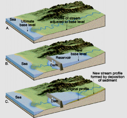
Base level: in geomorphology, the "base level" is the lowest point at which erosion can occur, or in the case of rivers, it's the lowest altitude at which a river can flow. A common base level for most rivers is the sea, though for some of them it might be a lake, a different river that the first river is a tributary to, or a dam.
The base level for any given river can change through time, since sea levels can vary, dams can be built, etc. A variation in base level, causes a variation in the river's energy, which can lead to more erosion, or more sediment deposition depending on if the river has more or less energy than before.
Here are two examples, the first is of a river whose base level dropped lower, it gained more energy and started eroding the substrate more, the second one is of a river whose base level was raised higher, and it started depositing more sediment to compensare with lowered energy.
This was an introduction to explain the concept of base level, now let's move on to knickpoints.
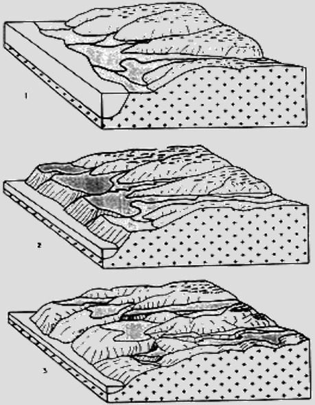
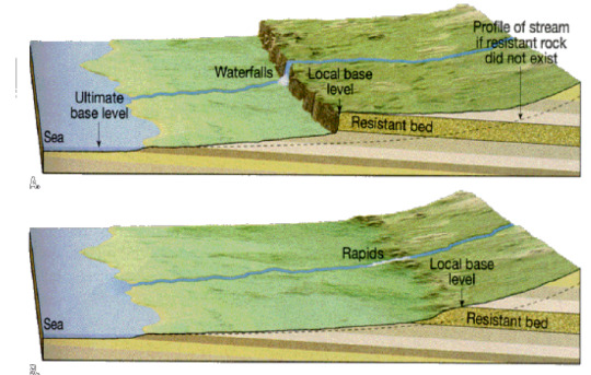
Knickpoint: a sudden and sharp variation of a river's slope, often leading to the formation of waterfalls and/or lakes. Some reasons why a knickpoint might form are: base level drop, tectonic activity, or a later of erosionally resistant rock:

There are generally two types of knickpoints: migrating and fixed.
Migrating knickpoints are mainly caused by base level drop and tectonic activity. They are called migrating because due to the erosion that the river applies on the substrate, the knickpoint is able to travel upstream. In the case of a base level drop type of knickpoint that affects an entire hydrography basins, usually the baisin will have all of its migrating knickpoints at the same altitude:

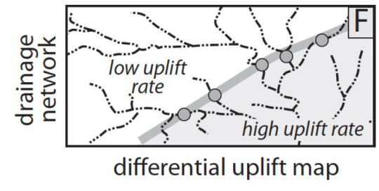
Sometimes, knickpoints are caused by differential uplift (two areas within a hydrographic basin are subject to different rates of tectonic uplift), and this causes a "barrier" of knickpoints that can easily be drawn within the baisin:
Fixed knickpoints instead are caused mostly by the presence of a layer of erosionally resistant rock, as it is something that the river cannot easily erode through, and will remain fixed.

Waterfalls can form from any of these kinds of knickpoints, it really depends on the river's erosion ability, it's energy, it's mass flow rate, the kind of sediments it carries, etc.
#geomorphology#original post#geology#this one was kinda dumb lol sorry but this exact topic kicked my ass yesterday
45 notes
·
View notes
Text
Pyramids are dams in the stream of time. Correctly shaped and orientated, with the proper paracosmic measurements correctly plumbed in, the temporal potential of the great mass of stone can be diverted to accelerate or reverse time over a very small area, in the same way that a hydraulic ram can be induced to pump water against the flow.
The original builders, who were of course ancients and therefore wise, knew this very well and the whole point of a correctly-built pyramid was to achieve absolute null time in the central chamber so that a dying king, tucked up there, would indeed live forever–or at least, never actually die. The time that should have passed in the chamber was stored in the bulk of the pyramid and allowed to flare off once every twenty-four hours.
After a few eons people forgot this and thought you could achieve the same effect by a) ritual b) pickling people and c) storing their soft inner bits in jars.
This seldom works.
--Terry Pratchett, “Pyramids” (SELDOM works???)
140 notes
·
View notes
Text
What are the Key Mechanical Properties of Solids?
Mechanical properties of solids refer to the characteristics that define how a material responds to external forces, such as stress, strain, and deformation. These properties include elasticity, plasticity, hardness, toughness, strength, and ductility, among others. They are fundamental in determining a material’s suitability for various applications, influencing its behaviour under different conditions.
The significance of mechanical properties spans numerous fields. In engineering, these properties ensure the safety and durability of structures like bridges, buildings, and dams. In construction, they guide the selection of materials for specific purposes, such as load-bearing or flexibility. Material science relies heavily on these properties to develop innovative materials that meet evolving industrial demands.
This article aims to delve into the science behind mechanical properties, their key characteristics, real-world applications, and their indispensable role in innovation and progress.
The Science Behind Mechanical Properties
Stress and Strain: Fundamentals
Stress is the force per unit area exerted on a material. It can be mathematically expressed as:
where is the applied force and is the cross-sectional area of the material. Strain, on the other hand, measures the deformation caused by stress. It is defined as the ratio of the change in length to the original length: where is the change in length and is the original length.
Types of Stress and Strain
Tensile Stress and Strain: Occurs when forces act to stretch a material. Examples include the stretching of rubber bands and cables.
Compressive Stress and Strain: Results from forces that compress or squeeze a material. Concrete in buildings often experiences compressive stress.
Shear Stress and Strain: Arises when forces are applied parallel to a surface. Scissors cutting paper is an example of shear stress in action.
Hooke’s Law and Elasticity
Elasticity is the ability of a material to return to its original shape and size after the removal of stress. Hooke’s Law describes this behaviour:
where is the Young’s modulus, a measure of a material’s stiffness. Elasticity is crucial for applications requiring temporary deformation, such as springs.
Plasticity and Permanent Deformation
When stress exceeds a material’s elastic limit, it undergoes plastic deformation, leading to permanent changes in shape or size. Metals like aluminium and copper exhibit plasticity, making them ideal for moulding and shaping processes.
Key Mechanical Properties
1. Young’s Modulus (Stiffness)
Represents a material’s resistance to deformation under tensile stress.
Example: Steel has a high Young’s modulus, making it ideal for construction.
2. Shear Modulus and Bulk Modulus
Shear Modulus measures resistance to shape changes under shear stress.
Bulk Modulus evaluates a material’s response to uniform compression.
Applications include hydraulic systems and pressure vessels.
3. Poisson’s Ratio
Describes the ratio of lateral strain to longitudinal strain. Materials with low Poisson ratios, like cork, are used for sealing applications.
4. Strength
Includes tensile, compressive, and shear strength. Determines how much load a material can bear without failure.
Example: Carbon fiber composites are used in aerospace for their high strength-to-weight ratio.
5. Ductility and Malleability
Ductility is the ability to be stretched into a wire. Copper’s ductility makes it suitable for electrical wiring.
Malleability is the ability to be hammered into sheets. Gold’s malleability is utilized in jewellery making.
6. Brittleness and Toughness
Brittleness: Materials like glass break without significant deformation.
Toughness: Measures a material’s ability to absorb energy before fracturing. Rubber is an example of a tough material.
7. Hardness
Resistance to indentation or scratching. Hardness tests include the Mohs scale and the Brinell test.
Example: Diamond, the hardest known material, is used in cutting tools.
Applications in Engineering and Design
Civil Engineering
Bridges: Steel and reinforced concrete combine high strength and ductility to withstand loads.
Buildings: Materials like concrete and glass are chosen based on compressive strength and aesthetic appeal.
Aerospace and Automotive Industries
Lightweight yet strong materials like titanium alloys ensure efficiency and safety in aircraft.
Automotive components use materials with high impact resistance, such as advanced polymers.
Manufacturing Tools and Machinery
Machine tools rely on hard materials like tungsten carbide for durability and precision.
Conveyor belts require toughness and flexibility to handle wear and tear.
Product Design and Safety Analysis
Consumer goods, such as smartphones, use materials that balance hardness and toughness.
Safety-critical systems, like helmets and airbags, are designed with energy-absorbing materials.
Material Science and Advancements
Developing New Materials
Nanomaterials and composites offer superior strength and lightweight properties.
Innovations like graphene enhance conductivity and mechanical strength.
Sustainability and Recycling
Recyclable materials, such as aluminium, reduce environmental impact.
Bio-based polymers provide eco-friendly alternatives for packaging and construction.
Future Trends
Smart materials, such as shape-memory alloys, adapt to environmental changes.
Research focuses on enhancing the durability of materials under extreme conditions.
The mechanical properties of solids are the backbone of modern engineering, construction, and material science. They ensure the safety, functionality, and efficiency of structures and products. By understanding and leveraging these properties, we can drive innovation, create sustainable solutions, and meet the challenges of an ever-evolving world.
As we continue to explore new materials and techniques, the importance of mechanical properties will remain at the forefront of progress, shaping a future of resilience and ingenuity.
For more simplified explanations like the one above, visit the physics blogs on the Tutoroot website. Elevate your learning with Tutoroot’s personalised Physics online tuition. Begin your journey with a FREE DEMO session and discover the advantages of online tuitions.
2 notes
·
View notes
Text


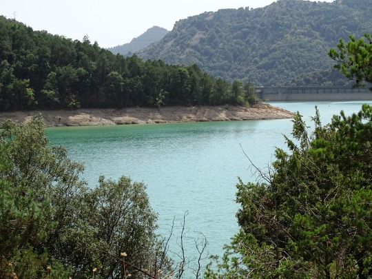


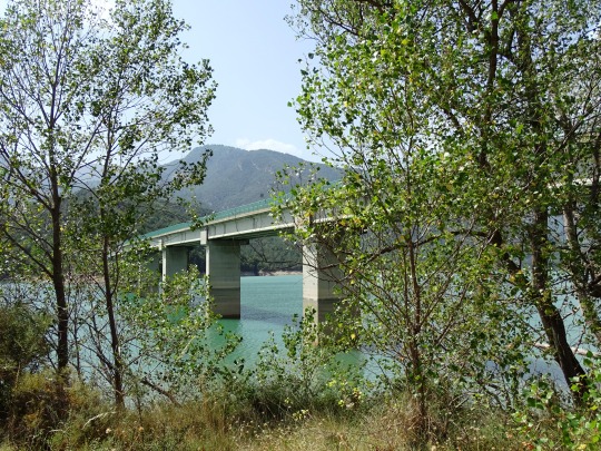
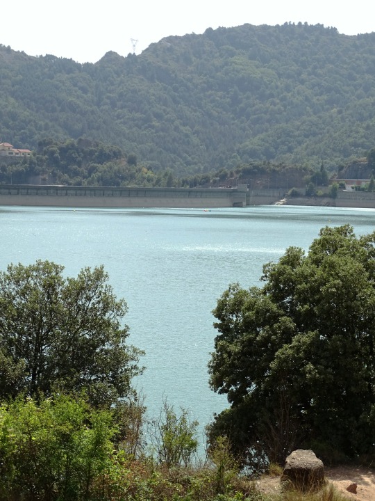
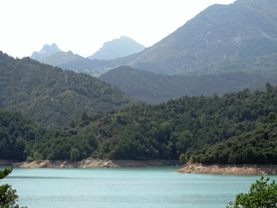
Pantà de la Baells, Spain (No. 1)
The Baells reservoir is a Spanish hydraulic infrastructure located on the Llobregat River, in the Bergadá region, province of Barcelona, Catalonia. It consists of a dam located in the municipality of Serchs. It extends through the terms of Serchs and Vilada, between the pre-Pyrenean mountains of Catllarás, to the east, and Figuerassa and Arades, to the west. To the right of the reservoir runs the C-16 road, between the Cadí tunnel and Berga-Manresa, and is crossed by the C-26, which links Berga and Ripoll.
The aim of the reservoir is to regulate the upper basin of the Llobregat River, supply water to the metropolitan area of Barcelona and produce hydroelectric energy.
Source: Wikipedia
#Pantà de la Baells#Baells Reservoir#lake#travel#original photography#vacation#tourist attraction#landmark#landscape#architecture#countryside#forest#woods#summer 2021#province of Barcelona#Catalonia#España#Southern Europe#Northern Spain#lake shore
21 notes
·
View notes
Text
An Acquired Taste
It was an uncommonly hot autumn day when Yulia Lebedeva first tasted fruit.
By the standards of New Seoul, the phrase ‘uncommonly hot’ seemed naive. From the great hydro-powered pumps and dams working around the clock to keep the Yellow Sea at bay, to the multicoloured throng of fans whirring from roadside bazaars, the city of twenty-six million was shaped, moulded, created by heat. It may not have been Hell, but there was no denying both places had a connection to the same feverish warmth.
The teeming thoroughfare of Sambong-ro yawned before her. Rickshaws shot past lumbering solar landbarges, the cacophony of pedalling legs and hydraulic whines drowned out by the background hum of sheer humanity. The pavements and main roads were supposed to be a pristine, reflective white: years of wear underfoot had turned them into a dirty ochre. It reminded Yulia of videos she’d seen about the Amazonian savannah, and the humans crawling across it of the late wildebeest; flowing like sand through fingers. Despite each individual destination, the masses kept an unconscious, graceful totality quite unlike anything she’d ever seen.
Nevertheless, it was a little overwhelming. Shuffling left past a haggling seaweed-seller and kicking aside a discarded plastic bag, Yulia eased her way into a claustrophobic canyon. Her first thought was that the sun had been inexplicably cut off; the staggering heights of the surrounding buildings had plunged this narrow alleyway into a strange twilight. Whereas before she had been sweating in the stagnant humidity, now an artificially funnelled breeze was at her back.
The light was bluer here, relying more on artificial lighting than the meagre strip of sky daubed overhead. Faded, mottled walls, a pervading sickly stench and a collection of ramshackle vendor’s huts conveyed the area’s poverty. A window-mounted softscreen overhead flickered and buzzed, sending a trail of boron-green sparks skittering down like ash from a cigarette’s tip. Music quietened as she walked further; the clang of metal gantries echoed above as inquisitive inhabitants rushed out, peering closely at the presumably lost foreigner.
The stench grew stronger as she reached the vendors and their wares; the faint, leafy scent of algae vats, the spicy, cloyingly sweet tang of soy-beef and the metallic stink of blood and assorted bodily fluids. An old lady, perched behind what looked to be a fruit stall, yelled a few words in what sounded like Mandarin. Yulia smiled back in what she hoped was an encouraging way and pointed to the translator device looped around her left ear. A moment later, the fruit seller’s words were whispered in perfect, monotone English, directly into her ear.
“Hey! Lost lady! Want to try some fruit? Real fruit, from Hokkaido, not vat-grown, no soy-fruit! 60 Sphere-yuan each!”
Real fruit? From a real tree? I’ll believe it when I see it, thought Yulia. The few remaining fruit plantations were guarded and tended to by corporations or the ultra-rich; not piled in front of a stall in some backwater New Seoul alley. She peered closer; the fruits were pear-shaped and a deep ruby red, with small green seeds rippling their skin. It was probably just another vat-grown scammer, she rationalised to herself.
Yet, her curiosity was piqued.
“Can I…” Yulia said slowly in English, pointing to herself, “...try one first?” she asked, pointing to the fruit and miming a bite. The woman nodded, and held out her right index finger to transfer the funds. Yulia’s fingerpad pressed against the old woman’s for a moment, then down, grabbing a fruit from the topmost row. A sharp word was uttered by the seller as Yulia brought the fruit to her lips.
“Enjoy!” said the translator as she bit down.
Her first thought was confusion. The flesh of the fruit was moist but not juicy, and had a surprising amount of thickness to it. It was almost…chewy? Crisp sweetness rolled around her mouth, a sugary taste so unlike the food tubes she was used to back home at the Institute. The seeds stuck to her teeth and cracked: they filled her mouth with a tart, sour tang. It seemed similar to the flavour pouches she’d once eaten marked ‘passionfruit’ yet a world away in execution. Delicious had never before seemed so ordinary a word.
“What…” Yulia asked, pointing at the fruit in an almost reverent way, “is this called?”
The fruit seller smiled, straightening her apron as she talked. The grin splitting her face made it seem as if she was chatting to an old friend.
The translation device filled in the gaps: her son was a genesplicer in Hokkaido North, and had sent his mother a bag of his corporation’s newest crop. Bad reviews had sunk the fruit’s commercial rating while thousands were still to be harvested; therefore, her son could send these discarded fruits to New Seoul for a very low price.
Yulia nodded. “How much for the rest?” she said, pointing at several fruits and then at her index finger.
“If you want a dozen, I'll charge 550 Sphere-yuan. Save you some money.”
Yulia shook her head and swept her arm in a wide arc, over all of the fruit. The old woman’s eyes widened and she ducked below the booth, muttering too faintly for the translator to hear. A moment later, she resurfaced with a fabric bag clutched tightly in her gnarled right hand.
“3,000 Sphere-yuan for the lot. You sure? I’ll tell my son: his fruit may not be successful in Hokkaido, but it certainly is here!”
Yulia nodded. Taking the proffered bag and briefly touching fingers again, she placed each fruit into the plastic bag, taking meticulous care not to bruise it. If she could return to the Institute with some of this… reverse-engineer it in the genetics lab… why, the fruits would be worth their weight in gold. No flavour pouch, no algae, no soy-meat would ever come close to the taste she had just experienced.
Smiling, she bowed to bid the fruit seller farewell, and continued further into the artificial canyon she found herself in. As the stall receded, the translator picked up one last, garbled whisper from the old woman’s direction.
“Tourist,” it said. Yulia thought she could feel the contempt, hidden somewhere in its impersonal tone.
#writeblr#writeblr community#my writing#short story#science fiction#cyberpunk#solarpunk#kinda between cyberpunk and solarpunk I guess#idk I wrote this over a year ago enjoy
10 notes
·
View notes
Text


Man's Impact on the Environment . 02 December 2024 . Mont-Saint-Michel . Normandy . France
Mont-Saint-Michel (French pronunciation: [lə mɔ̃ sɛ̃ miʃɛl]; Norman: Mont Saint Miché; English: Saint Michael's Mount) is a tidal island and mainland commune in Normandy, France.
The island lies approximately one kilometre (one-half nautical mile) off France's north-western coast, at the mouth of the Couesnon River near Avranches and is 7 hectares (17 acres) in area. The mainland part of the commune is 393 hectares (971 acres) in area so that the total surface of the commune is 400 hectares (990 acres). As of 2019, the island had a population of 29.
The commune's position—on an island just a few hundred metres (yards) from land—made it accessible at low tide to the many pilgrims to its abbey, and defensible as the incoming tide stranded, drove off, or drowned would-be assailants. The island remained unconquered during the Hundred Years' War. A small garrison fended off a full attack by the English in 1433. Louis XI recognised the benefits of its natural defence and turned it into a prison. The abbey was used regularly as a prison during the Ancien Régime.
Mont-Saint-Michel and its surrounding bay were inscribed on the UNESCO list of World Heritage Sites in 1979 for its unique aesthetic and importance as a Catholic site. It is visited by more than three million people each year, and is the most-visited tourist attraction in France outside of Paris. Over 60 buildings within the commune are protected as historical monuments.
In 2023, President Macron marked 1,000 years of the abbey, and the success of the hydraulic dam project and the elevated pedestrian bridge in restoring water flow in the bay, making the mount an island again.
2 notes
·
View notes
Text


.
The famous Mont Saint Michel.
The crown jewel of Normandy (even Brittany try to claim it as their own!!)
Arriving a little too late for the sunset at Mont Saint Michel (the day are indeed short in November) and leaving as the rain was starting to intensify.
Mont-Saint-Michel and its surrounding bay were inscribed on the UNESCO list of World Heritage Sites in 1979 for its unique aesthetic and importance as a Catholic site. It is visited by more than three million people each year, and is the most-visited tourist attraction in France outside of Paris. Over 60 buildings within the commune are protected as historical monuments.
In 2023, President Macron marked 1,000 years of the abbey, and the success of the hydraulic dam project and the elevated pedestrian bridge in restoring water flow in the bay, making the mount an island again.
3 notes
·
View notes
Text


Mega Schemes
Huge hydraulic schemes are made possible by advanced modern civil engineering techniques. They require vast international contracts that are only possible at the level of central governments, international free floating capital and supranational government organisations. The financiers borrow money and lend it at commercial rates, so they favour largescale engineering projects that promise increasing production for export markets at the expense of local subsistence economies, with disastrous social and environmental effects. Cash crops destroy settled communities and cause pollution of soil and water. For instance, Ethiopia’s Third Five-Year Plan brought 60% of cultivated land in the fertile Awash Valley under cotton, evicting Afar pastoralists onto fragile uplands which accelerated deforestation and contributed to the country’s ecological crisis and famine. There’s a vicious circle at work. Development needs money. Loans can only be repaid through cash crops that earn foreign currency. These need lots more water than subsistence farming. Large hydraulic schemes to provide this water are development. Development needs money. And so it goes.
Large-scale projects everywhere are the consequence and justification for authoritarian government: one of America’s great dam-building organisations is the US Army Corps of Engineering. Stalin’s secret police supervised the construction of dams and canals. Soldiers such as Nasser of Egypt and Gadafi of Libya and military regimes in South America have been prominent in promoting such projects. Nasser built the Anwar High dam in 1971. The long-term consequences have been to stop the annual flow of silt onto delta land, requiring a growing use of expensive chemical fertilisers, and increased vulnerability to erosion from the Mediterranean. Formerly the annual flooding washed away the build-up of natural salts; now they increase the salt content of irrigated land. The buildup of silt behind the dam is reducing its electricity generating capacity; the lake is also responsible for the dramatic increase in water-borne diseases. Nationalism leads to hydraulic projects without thought to what happens downstream in other countries. The 1992 floods of the Ganga-Brahmaputra-Barak system killed 10,000 people. 500m people live in the region, nearly 10% of the world’s population, and they are constantly at risk from water exploitation and mismanagement. Technological imperialism has replaced the empire building of the past: large-scale hydro projects are exported to countries despite many inter-related problems – deforestation, intensive land use and disputes and so on. Large-scale water engineering projects foment international disputes and have become economic bargaining counters, for example the Pergau dam in Malaysia. The British Government agreed to spend £234m on it in 1989 in exchange for a £1.3bn arms deal. In 1994 the High Court ruled that the aid decision was unlawful but these kinds of corrupt deals continue.
In Sri Lanka the disruption caused by the Mahawelli dams and plantation projects resulted in the forcible eviction of 1 million people and helped maintain the insurgency of the Tamil Tigers that resulted in thousands of deaths as they fought government forces from the late 1980s onwards. In 1993 the Marsh Arabs of southern Iraq were threatened by Saddam Hussein’s plans to drain the area – the most heavily populated part of the region. Many of the 100,000 inhabitants fled after being warned that any opposition risked death. Selincourt estimated that 3 million people would lose their homes, livelihoods, land and cultural identity by giant dam projects in the 1990s. The Kedung Ombo dam (Indonesia) displaced 25,000; the Akasombo dam (Ghana) 80,000; Caborra Bassa (South Africa) 25,000. Three dams in Laos alone will have displaced 142,000 people. The proposed Xiao Langdi dam in China would displace 140,000; the Three Gorges project 1.1 million people. Only war inflicts a similar level of human and environmental destruction, yet large dam projects have a chronic record in delivering water and power, or eliminating flooding in downstream valleys.
#freedom#ecology#climate crisis#anarchism#resistance#community building#practical anarchy#practical anarchism#anarchist society#practical#revolution#daily posts#communism#anti capitalist#anti capitalism#late stage capitalism#organization#grassroots#grass roots#anarchists#libraries#leftism#social issues#economy#economics#climate change#climate#anarchy works#environmentalism#environment
2 notes
·
View notes
Text
My son has decided that dams are his focus for the day, and we’re leaning into it for homeschooling.
Now I get to hear about him building a dam turbine, a dam structure, we took a dam walk to see the local dam. Now he’s wondering if there are dam hydraulics. He drew a dam diagram, did a dam coloring page, and we watched some dam videos. He’s got more dam knowledge in his little noggin than most 7 year olds and he’ll gladly explain to you how the dam water turns into dam power (it’s dam turbines and generators).
I am delighted and he has no idea that there’s a joke floating around in all this. He’s just excited about dams.
#adventures in homeschooling#learning to lean into and direct the hyperfocus instead of fighting it this year#he’s happily done a bunch of class work today because it was themed around his interest of the day
2 notes
·
View notes
Text
Oh yeah, hard to miss the news yesterday about the big as hell dam breaking in Ukraine. I have peripheral experience with hydropower, and I called pops to talk with the man about it - as he has worked in the biz for over 30 years.
And it was a bleak rundown I got. Normally, in any flood like this it leaves the farmland pretty much unusable for years with trash and debris floating over it - but the 150 tons of hydraulic oil will be the worst of it.
And that will likely destroy the farmland for years to come. And then there is not to mentioned the Russian landmines being washed away and deposited who knows where. If not blasting some poor farmer or child, they will rust and seep out chemicals into the ground around it.
And there is little chance of it being a Ukrainian operation. Russia threatened to destroy it before, and artillery will not break the concrete housing or the doors. It needs to be a deliberate task of sabotage to make that happen.
And this will be one mighty “F.U” to Ukraine to destroy the power infrastructure. But I somehow believe it is entirely in line with military commanders from that side of the conflict to make petty and vastly ill-informed decisions like these.
8 notes
·
View notes