#Hells Canyon (Geographical Feature)
Explore tagged Tumblr posts
Photo
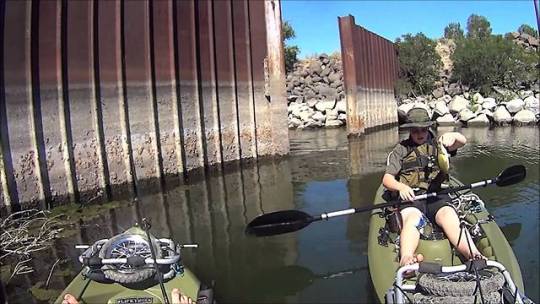
Smallmouth Frenzy!! 2015 Snake River Smallmouth Bass fishing This is a trip we do every year. This year I did more research on the fishing about the Snake River so this was some of the best fishing we've ever had. The more ... source
#Bass Fishing (Award-Winning Work)#Clarkston (City/Town/Village)#Fishing (TV Genre)#Hells Canyon (Geographical Feature)#Hells Gate State Park (Protected Site)#Idaho (US State)#Kayaking (Sport)#Lewiston (City/Town/Village)#Smallmouth Bass (Organism Classification)#Snake River (River)#United States Of America (Country)#Washington (US State)
1 note
·
View note
Photo
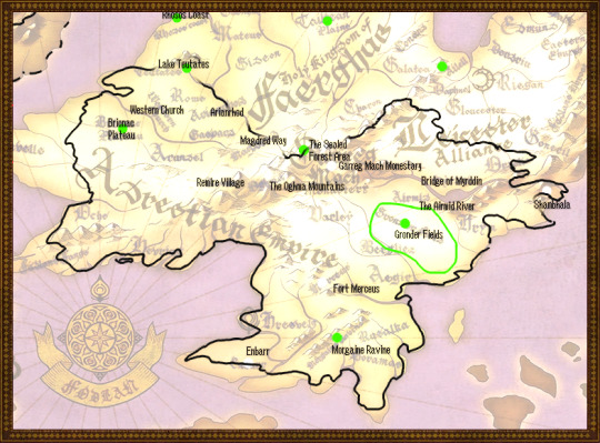
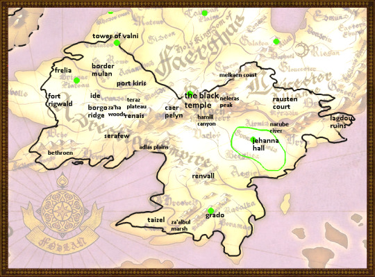
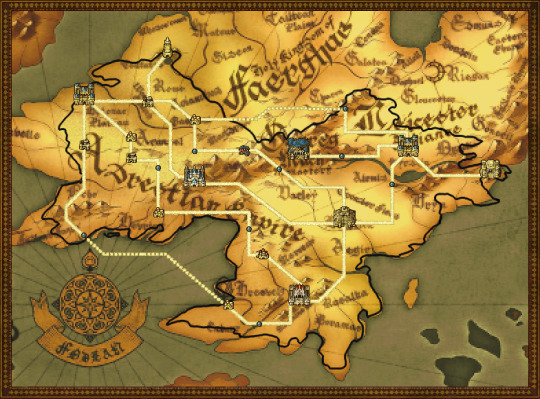
The United Fódlan-Magvel Post-Time Skip Map, Type 1
Previous Post | Next Post
-
FIGURE ONE
Figure One is simple enough, it’s just the important places in Fódlan with names on it.
FIGURE TWO
This is where it gets juicy. We’re going to go through each of these places more or less individually, so this is going to be a long post, be forewarned. Now, all of these are located roughly where they ought to be in relation to one another. Which means, in many cases there isn’t much choice behind the decision. Still, there was at least a little bit!
[Keep Reading Link Below]
North Magvel
The Black Temple
The Black Temple was placed directly on top of the ruins of Garreg Mach Monastery, as detailed in Post One. This is the site of the Holy Mausoleum, and makes a perfect one-to-one translation to the place where the Demon King Fomortiss’ body will be sealed. Likewise, Garreg Mach is located right next to the Sealed Forest, the one place in Fódlan known for, well... sealing and darkness. From the Sealed Forest will come Darkling Woods. This leads us nicely to...
Caer Pelyn
As some of you may yet be tired of hearing from me, Morva makes a wonderful Seteth. Caer Pelyn has to be near the Black Temple anyway, but there’s something terrifically poetically sad about the last Nabateans hovering around whats left of Garreg Mach.
Neleras Peak
Let’s go ahead and say that whatever disaster laid waste to Faerghus and the Alliance, it involved the javelins of light. One was sent to Garreg Mach, but, as we know, it is protected. Instead, Neleras was detonated, and left in a state of lava-y Ailell hell.
This, again, is is the only site whose location will be completely disregarded. I feel like putting it here again so you don’t have to click all around: in the lore, Mt. Neleras is supposed to be within the Darkling Woods. The Darkling Woods is centered around Caer Pelyn and the Black Temple. Now, the way I see it, you could have that forest cover all that land and still reach across the continent across two countries to where Mt. Neleras is supposed to be. You could also not do that very unpleasant thing. Just- just move it. It’s easy. Look, I’ve done it myself right here.
Melkaen Coast
It’s a coast. It’s located on a coast. Nothing special going on here.
Hamill Canyon
We’ve moved this quite a far bit. For one, a large offshoot of mountain range is no longer here in places. For two, remember that chasm Byleth fell into? Yeah, me too.
.
Midwest Magvel
Renais
Renais grew from what was left of Remire Village. Much like on the original map, it is protected on the east by mountains, which also render Caer Pelyn inaccessible from Renais.
Za’ha Woods
Now, if I were to remake this map, I’d stick the Za’ha Woods in the Sealed Forest, because Zahras is too linguistically close for me to not want to line them up.
Borgo Ridge
There is actually a small ridge on the Fódlan map right in the vicinity of where Borgo RIdge needs to go. So that was a no-brainer.
Teraz Plateau
It’s a plateau. Near vaguely altitude-y places. Not much else to say here.
.
West Magvel
Frelia
Frelia is located within range of the Brionac Plateau. You have no idea of deeply desperately I wanted to put it ON the Brionac Plateau. A pegasus-culture located on a giant fantasy plateau? SIgn me the fuck up. Anyway, Frelia is SUPPOSED to be on the coast, though. So, on the coast it goes. Why are there so many plateaus on this map anyhow?
Fort Rigwald
This isn’t located near anything important on the Fódlan map. The Magvel country borders are quite different, so it makes sense that new forts would have to be constructed. I’m still sad about it, though.
Border Mulan
On the Fódlan map, this location is listed as the Western Church. We will assume for this map that whatever they built was strong, and exists in some for or another in Magvel time. At any rate, this location is now Border Mulan.
Ide
North of Borgo Ridge. End of statement.
The Tower Of Valini
This is located on Lake Teutates. There already is the ruins of a tower there already so. Why the fuck not?
(Answer: because Lake Teutates sucks and I wish I could wipe it off the map with my bare hands. Indech do not interact.)
Visual aid for those of you who haven’t been forced to look at Lake Teutates for fifty thousand years and also never used the zoom in mode:
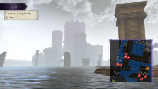
Some other interesting information about Valni/Teutates here:
Valni is Russian for waves (волны). Interestingly enough, the singular form волна is the name of a specific submarine launched ballistic missile.
The Tower of Valni is, of course, notable for having those terrifically obnoxious light beam weapons. Three House is, of course, notable for dropping actual fucking missiles on you. Missiles called javelins of light.
I’m bolding all of that because I’m very excited about it.
Port Kiris
Port Kiris is located in Magvel near the coast of the Northern Sea. I made a minor error in this map, and didn’t place Kiris far enough west. Anyway, in this map Kiris is also located at the end of a river that connects it both to Border Mulan and Frelia, which gives this town more trade power. It is a sea port and also, a river port. Hurray!
.
The Bay
Serafew
Serafew could be in a range of places. We’ve placed it in the central north of the bay. It is fed by a whole lot of rivers, which would help maintain the city from a logistics point of view. I’m guessing they have a lot of fertile land from the Adlas Plains, as well.
Adlas Plains
Adlas remains at the north mouth of the bay. There is a notable lack of Adlas’s forests in Fódlan’s map; on the other hand, there aren’t really any forests displayed on the map.
Bethroen
Bethroen’s path on the Sacred Stone’s map curves oddly; here, that is replicated and also reinforced by the mountains that back Bethroen. Presumably, here the path is curved because it is a path through the mountains.
.
South Magvel
Renvall
I really wanted to put Renvall on the ruins/same place as Fort Merceus. Renvall is also located, though, at the base of a river. There is one of those slightly to the left of Merceus. Plus, as we’ll get to in a second, Grado has a pretty set location. All of that means Renvall can’t really go on Merceus. It’s honestly the most reasonable choice, given what happens to Merceus in some of the routes.
At any rate, this is generally where Renvall goes. South east of Adlas, north of the Empire. Both Grado and Adrestian.
Taizel
Taizel is probably the one I’m least happy with. That area on both to Fódlan and Magvel map is occupied. However, in Magvel, that spot is just some town, whereas in Fódlan, its the whole capital of the empire. 800 years is a long time, but to completely wipe the importance of such a well established city? I just don’t know.
Either way, the location lines up wonderfully. As an additional note, both Enbarr and Taizel have rivers to the east of them, and this is continued here.
Za’abul Marsh
It’s a marsh. It goes both near a river, and directly between Taizel and Grado. Not much interesting happening here as far as all that goes. Fódlan provides that excellent river mentioned above.
Grado
Ah, the big one of the region. Grado is near the peninsula. It’s not directly below Renval, or Jehanna Hall, but rests somewhat inbetween the two as far as longitude goes. This area on the Fódlan map has something called the Morgaine Ravine. Now, I’ve finally finished all four routes and as far as I can tell, this fucker has come up exactly zero times. Still, it’s a place notable enough to get a name on the map, and more than that, it’s got earth-splitting connotations with that ravine name. Sounds like a perfect place to stick Grado’s capital if you ask me.
.
East Magvel
Jehanna Hall
I am so tired. Okay. Three left. So, Jehanna. I don’t know about you, but when I see a gigantic tasty fields-and-plains region, I think, what if desertification? Anyway the point is, Gronder et al. can’t stay delicious and green forever. Especially with everyone and their brother dedicated to fighting on it, or burning it down, or stepping all over it, etc. On this map, this area becomes the desert that Jehanna Hall sits itself right down in.
Now, if only I could figure out who Metis is...
Narube River
Now, strictly speaking, the Narube is located to the east of Jehanna Hall. Why be strict, though, when the Airmid is right there. I mean, its right. there.
Rausten Court
“Hey, wait!” you cry. “Where the hell did Neleras go?”
“Now hang on,” I say. “I feel like I ranted about this. I mean though I can definitely go again, here let me just get my-”
Okay, now Rausten Court
Rausten lies across the River, to the east of Darkling, and occupies its own space away from everything else, really. Of note here is that it’s right behind the Great Bridge. I think that’s pretty neat.
Lagdou Ruins
FINALLY! I‘VE BEEN WAITING FOR THIS ONE.
Shambhala. End statement.
Alright, not actually the end of statements. But let me just say: Shambhala got hit by missiles, not destroyed. If people can make it out of there, bits of that place are still intact. And that’s setting aside the fact that, if you look in the zoom in map, that place is a hell of a lot bigger than just the field of combat. Anyway. All that I’m saying: Shambhala real.
AND, lest we forget. The ninth floor of Lagdou is in fact lava-burn-y. Which could jsut mean lava... or the predictable and regularly desribed aftermath of the lances of light that Shambhala gets hit with in canon.
Anyway. All that I’m saying: Shambhala real.
Because of this, Lagdou has experienced a bit of a shift. It is still located next to all the proper geographical feature, it is just that the removal of Neleras means that part of the continent is a bit stretched.
.
Aaannnd that’s the end of this post! Stay tuned for the next post, which is just the nice final fancy map.
2 notes
·
View notes
Photo

General traditional distribution of Indigenous peoples of the “Plateau culture region” of the Inland Northwest
Tribes more closely affiliated with forest/mountain ecology and Salish culture/language: 01 - Kutenai 02 - Kalispel (”Pend O’Reille”) 03 - Salish (”Bitterroot Salish”) 04 - Skitswish (”Coeur d’Alene”) 05 - Spokane 06 - Sanpoil 07 - Sinixt (”Lakes”) 08 - Syilx (”Okanogan”) 09 - Secwempec (”Shuswap”) 10 - Chilcotin 11 - Lillooet 12 - Nlaka’pamux (”Thompson”) 13 - Nicola Tribes more closely affiliated with prairie/steppe ecology and Penutian culture/language: 14 - Niimiipuu (”Nez Perce”) 15 - Cayuse 16 - Umatilla 17 - Palus 18 - Columbia 19 - Methow 20 - Wenatchi 21 - Kittias 22 - Yakama 23 - Klickitat 24 - Wishram 25 - Tenino 26 - Molalla
Notice how Salishan peoples generally utilize forest and mountain landscapes, while Penutian and Penutian-adjacent peoples generally utilize drier steppe, foothills, and prairies.
Please let me know if some of these tribal names need to be edited to remove racist language and outdated terminology!
(I get tired, sometimes, of not being able to find good maps of the US distribution of Indigenous people, so I end-up making my own by studying multiple papers, books, tribal websites, ecological/topographical maps, and historical maps. Canadian First Nations, organizations, and government agencies seem to have much better maps available.)
(The base layer for the map is from Raven Maps.)
-
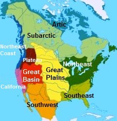
How the Plateau culture region compares to the other major culture regions of North America. [Map via Wikimedia Commons.]
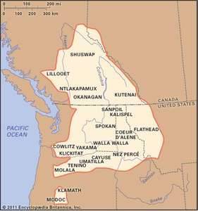
Another look at the Plateau culture region. [Map via Britannica.]
An even better map, provided by the Sinixt tribal website. Plateau culture region is displayed in green.

-
Here’s a look at the distribution of Salishan languages, via a map by Natural History Magazine:
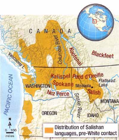
Salishan languages exist in both the Plateau culture region, and the Northwest Coast culture region along the Salish Sea. Though these two culture regions are generally very different, there actually are a few very important shared qualities of the coastal and inland landscapes where Salish languages are common: temperate rainforest. Cedar-hemlock forests and rugged mountain-valley systems exist both on the coast and in eastern BC, eastern Washington, and the Idaho panhandle. Many plant, amphibian, and invertebrate species that live in the coastal rainforest also have similar analogous species living inland. So, Salish language used to describe coastal environments can also be used to describe the similar ecological features farther inland in the Plateau culture region.
-
Ecoregions and the environmental influence on culture
Local geographic/ecological regions of the Inland Northwest correspond extremely well with the historical boundaries between cultures.
For example, the Klickitat people (#23) traditionally live in an area precisely corresponding to a California-style oak woodland area on the east-slope of the Cascades. Most permanent dwellings of the Kalispel people (”Pend O’Reille” tribe - #2) occur an area which outlines the low-elevation ponderosa along the banks of the Pend O’Reille River. The Skitswish people (”Coeur d’Alene” tribe - #4) inhabited a region also neatly outlining the fertile inland temperate rainforest of the Coeur d’Alene and Clearwater Mountains. The Nez Perce people (#14) inhabited the Hells Canyon and Clearwater Canyon systems that separates the Blue Mountains and Columbia Basin from the Rockies.
The Plateau culture region is a pretty neat outline of distinctly “Inland Northwest” ecoregions. Check-out how well the Plateau culture region corresponds to a the “Level III” ecoregions recognized by the US EPA and many environmental geographers:

Specifically, the East Cascades (#9); the Columbia Basin (#10), the Blue Mountains (#11); and the Columbia Mountains inland rainforest zone (#15) collectively correspond pretty well with the Plateau culture region.
-
So, I think that a nice way to conceive of the boundaries of the “Inland Northwest” as a region is to consider how both PNW ecology and PNW Indigenous culture share these pretty similar boundaries.
15 notes
·
View notes
Text
On Mars
Things I love about Mars: the landscape.
Mars's landscape is both alien and familiar. There are other fascinating landscapes in the Solar System, of course: Venus, Pluto, Europa, Titan, etc., and each has their charms; but the thing about those landscapes is that the environment in which they're found makes them more alien. Venus has mountains and plains and, like Earth, few craters; but the crushing sulphuric pressure of the atmosphere and the fact that every few hundred million years it seems the entire planet may go molten and resurface itself makes Venus a setting for hard SF, or individualistic person-versus-environment stories: the narrative that suggests itself to me when I imagine standing (in some megaspacesuit) on the surface of Venus is not "this is a place humans could one day be," but "this is an unpeopled Hell."
(Also: apparently Venus may have had liquid water as recently as 700 MYA. Life on Earth seems to have arisen almost immediately, as soon as the conditions potentially favorable to it existed. From the formation of its oceans to 700 MYA, Venus would have been climactically stable, thanks to higher cloud cover than Earth. So it is entirely possible that for a couple of billion years, between the oceans of Venus forming and the runaway greenhouse effect destroying them several hundred MYA, Venus had life, up until the Neoproterozoic period on Earth. But if the theories regarding how energy is released into Venus's dessicated crust are correct, the fossil evidence of that life would have been annihilated in the same event that resurfaced the entire planet some time in its geolocially recent past. Perhaps fragments of it persist, floating deep in the mantle like the Farallon plate on Earth--but for now, an actual record of the biohistory of Venus is lost to us. What I'm saying is, Venus is a postapocalypse: not a hopeful Perelandra, not even in the far future, but a grievous memorial for what might have been our lush and gardenlike neighbor.)
Titan, Europa, and Pluto--although they have very different landscapes--have a common feature, which is that waste heat from technology (heck, from human bodies) would melt or boil their surfaces. Pluto is especially bad in this regard, given that its plains are 98% nitrogen ice. Humans on Pluto would be creatures of unquenchable fire, destroying everything they touched. Europa is much more familiar, especially if it has warm seas beneath the ice; but its landscape is a vast broken plain of ice, possibly with a band of peninent spires rising into the sky at the equator. It's metal as fuck. But the airless, radiation-bathed surface is, again, seems to be suited mostly to being a vehicle of existential exploration, and the subsurface ocean may just be a hopeful dream, like the jungles of Venus. Titan, that weird little orange goofball, also has a water ice surface, plus a hydrocarbon "hydrosphere" which is fascinating! It's the first time the IAU has had to come up with a naming convention for actual bodies of liquid on a planet's surface. It has lakes! Inlets! Seas! But it's tiny, has very little gravity, and if you tried to terraform it even a little bit the entire thing would melt or evaporate. There are stories I would happily tell on Titan. I can even imagine they would have some features of the stories I would tell of an Earthlike world: here is a political boundary following a river, here are pirates on the Ligeia Mare (pirates on a methane sea, frost condenses on the inside of the hull even through half a meter of insulation, we haven't seen sunlight in weeks, we haven’t seen the sun since we were born). But the strictures of the environment also demand a more hard-SF sensibility, and a hard-SF sensibility applied to the "soft" aspects of science fiction: how do the constraints of the environment shape how societies function? How is politics, war, and economics different in a place where atomic individualism isn't just maladaptive, but maybe impossible? I've thought about these questions in other contexts (deep space, settlements on airless rocks), and although Titan expands the possibilities somewhat, it doesn't expand them much. But it's definitely my third favorite body in the Solar System (after Mars and, of course, Earth).
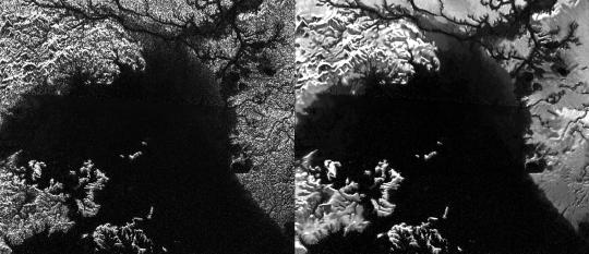
[Ligeia Mare, the second-largest lake on Titan, 78° N, 249° W .]
The rest of the solar system is either gas giants (which fill me with too much dread to really apprehend them on an immediate or aesthetic level; what hubris is it to try to imagine a little human soul against the endless storms of Jupiter?), or small, airless bodies specked with craters. Some of these verge on the utterly uninteresting. Io is at least respectably garish. But the narrative context they suggest to me is the same as Titan, shorn of the unique geographical points of interest that moon offers, and while that doesn't mean they're not interesting, they don't excite me nearly as much. I am glad they exist. Some are really beautiful (speckled Ganymede! gleaming Eceladus, Europa's twin! what the fuck is wrong with you Iapetus!).
(What did we do as a species to deserve a Solar System full of so many different, beautiful worlds? How much wonder is there in the rest of the Universe if this little corner is already so full of it?)
But Mars. Ah, Mars. You know, my head says that interplanetary colonization would be a waste of resources and, lacking a useful economic purpose, ultimately a giant boondoggle. There are inhospitable environments on Earth that are, against Mars, an Eden, and we have yet to people them; if science is our aim, even the practical benefits of a manned mission to Mars stop at orbiting the planet and controlling robots remotely below. And I know all this. But there's a quiet voice in the back of my head--quiet only because like the rumble of distant thunder it is spoken at much deeper frequencies, frequencies of the ground beneath my feet and of my soul itself--that says if I don't die having crunched the grit of Mars beneath my feet or run its dust between my fingers, my life will have been empty and devoid of purpose. Not to get too metaphysical on you, but I'm pretty sure there's a part of my soul that is convinced it was meant to be born on Mars, meant to wander the Kasei Valles and the Tharsis plateau, that longs to stand on the Olympus Rupes and watch the dust storms on the Amazonia Planitia below; to sojourn in the Labyrinth of the Night, filled with fog from sublimating frost.
Mars is alien. Mars is not like Earth. Yet its appearance suggests a world we almost know: here are canyons, here are sinuous valleys, here are dusty plains. On closer inspection, these things reveal their true, unearthly nature: this is a canyon as long as Europe, yawning deeper than the mountains rise. This is a volcano, yes--it is the size of France. If you stood on its summit, very nearly above the top of Mars' atmosphere (which is taller than Earth's!), its slopes would disappear around the curve of the world before you saw their end. These valleys are not river valleys: they are ancient outburst channels, the catastrophe that scoured out the Channeled Scablands--over, and over, and over again. The atmosphere is gasping-thin, and often choked with dust. The surface is freezing. Nothing lives, not so far as we can tell. But you can imagine yourself there. I wonder why?

[The informally-named “Columbia Hills,” Gusev Crater, Mars, 14.5°S 175.4°E. Mosaic image taken by the Spirit rover. The distance is about 300 meters to the base of the hills.]
Part of it, of course, is the wonderfully detailed photography from Mars missions, and the fact the planet is extensively mapped--one of the best-mapped bodied in the Solar System. As part of the Inner Solar System, we can orbit it comparatively easily, and we don't have to rely on photos snapped during quick flybys. (The USGS has complete, detailed maps of Mars available for free! The USGS is a freakin’ international treasure.) I think Mars more easily than most worlds in the Solar System is a canvas onto which we can imagine projecting the psychodramas of our own history. If the "minor" objections of its ultrafreezing surface and its unbreathable, thin atmosphere can be overcome, we can almost imagine it like any other harsh desert into which human habitation has intruded (and humans, like a gas, do tend to occupy all available space). And those objections can be overcome, if we are patient and work very hard, and they can be overcome without annihilating the surface of the world. It would be possible to blanket Mars in a thick, carbon dioxide-rich atmosphere and bring its temperature up to, say, Antarctic levels (i.e., you could survive indefinitely in very warm clothing with a breathing apparatus) with several centuries or possibly a millennium of the diligent application of existing technology. We have no reason to do it right now, and it would be madness to try, but it's doable--so one day, we might.
And if we did? Well, I'd like to think that the species that did that would be, after Carl Sagan, a species very like us but slightly better in important ways, and that by then Earth would be a much nicer place to live; and Mars, therefore, by extension, would be a more rugged and difficult environment but still full of basically decent people who have solved problems like poverty and oppression and large-scale warfare. With a light brushing of a sort of Mad Max visual aesthetic, what with all the breathing masks and the exposed ductwork. Hopefully they would continue the IAU trend of giving everything really atmospheric names, so we wouldn't have the place carpeted in stupid shit like "New Canada" and "President Reagan Land", like Antarctica has been. (Seriously, the IAU needs to take over naming stuff in Antarctica, it's dire down there.)
There is another possibility of course, and in my mind that possibility is inextricably linked with the fact that Mars is small. Mars, like Earth and Venus, probably formed with a dense atmosphere. Its coldness, believe it or not, is not a feature of its distance from the Sun. That's a common misconception. The approximate habitable zone of a G-type star like the Sun extends from within the orbit of Venus to just to, or slightly beyond, a planet at Mars's distance (1.5 AU or so). Venus, for its part, was doomed by being just too warm, and, as the Sun aged and its energy output increased, the homeostasis of its environment being tipped a little bit too far, until the whole thing collapsed, the seas evaporated, and the water vapor was shorn apart by ultraviolet energy, its hydrogen scattered into space by solar wind. But Venus is big. Venus could hold on to its atmosphere regardless. Mars could not. Though further from the Sun, and initially with its own hydrosphere (which now sleeps frozen beneath its crust and at the poles--which have enough water in them to deluge the surface meters deep), the solar wind gradually stripped away Mars's atmosphere, until it was unable to trap heat, and liquid water ceased to be able to exist on its surface for more than the briefest periods of time. Earth, too, would be frozen desert if it had an atmosphere like Mars.
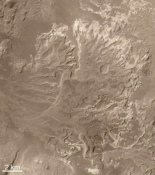
[A Noachian-era alluvial fan in Eberswalde Crater, 24°S, 33°W . Many Noachian-era craters show evidence of having once been filled with water. The aptly-named Noachian period was the last time surface water might have been abundant on Mars, and ended roughly 3.7 billion years ago.]
Any atmosphere we give Mars is doomed in the long run--on the order of thousands of years, not millions. Any civilization we engender on Mars is not a civilization for eternity: it is doomed from its beginning. If we are less wise than we hope, less able to cooperate than we wish, less able to accomplish the miracles of terraforming that we require, the saga of human habitation on Mars will not be the saga of overcoming the frontier, of planting a new, bright tree of our people on a neighboring world; it will be a saga of a promising beginning and then a long--terribly long--slow decline. The Martian desert will slowly cover cities and whatever little groves of life we plant; our first, tentative seas will dry up; increasing scarcity will become the norm, not for a few generations, but for whole civilizations, until the entire memory of the world is nothing but a medieval feeling of decline, of loss, of some ancient glory which we cannot quite remembering being forever beyond our reach. The midcentury scientific romances of a dying Mars were true, but they were not accurate assessments of the present or the past. They were prophecy--a prophecy which is not guaranteed, but which should serve as a warning nonetheless.
Again, my interest in these concepts is mostly from the standpoint of fiction and imagination. Colonization of Mars is a long, long way off, and sitting here in the mythic past of any future Martian civilization, with a warm green spring outside my window and the luxury of breathing free oxygen kindly manufactured for me for free by the native biosphere, I would be surprised if any future settlement of Mars unfolded more than a little bit in the way I expect. Nonetheless, these are the thoughts that occur to me as I pore over maps of Mars. Here, the Chryse Planitia. Here, the graceful curve of the Claritas Fossa. Here, Elysium, its scattered features named for the abodes of the dead. Here, the illimitable Vastitas Borealis. Here, the Chasma Australe, which cuts deep into the southern Martian pole; where Edgar Rice Burroughs might have imagined the ten-thousand mile River Iss. I know that I will probably never see this world with my own two eyes. But God Almighty! I would give anything!
395 notes
·
View notes
Text
Shooup
I first bumped into Tony Sandeberg, the Managing Director of ShooUp, at the 2014 TdU Village. Tony had some prototype rear lights he was trying to get off the ground. We got a prototype over into the Wednesday Legs test labs a few months later but we had a few issues and ended up sending it back sans review.
I touched base with Tony a few weeks back to see where he was at, whether he had decided it was all too hard, or whether he had persevered.
I was pleased to hear back from Tony saying that he had persevered, and was a finalist in the Cycling Promotion Fund, a national event. That followed up from being shortlisted in ”The Australian Innovative Challenge in Oct 2012.
From the Shooup website:
Shooup Liverider was invented in 2012 by adventurer and cyclist Tony Sandeberg. After continually hearing on the media “ another cyclists killed on our roads “ and one too many close calls, Tony had enough and decided to develop a product that would literally redirect cars safely away from the cyclist. That passion and determination underpinned the product development process that has resulted in the most innovative and effective rear safety bike light available today.
ShooUp Liverider is a new rear safety bike light designed to help save cyclists’ lives. The aerodynamic wing shape of 21 high visibility strobing red LED’s from the rear and 8 white LED’s facing oncoming traffic extends 265mm redirecting drivers safely away from the rider, providing added cycling confidence.
Main body is secured by a dynamic flex-back mechanism protecting it from knocks and impacts
Liverider quickly detaches from seat post mount for security and mini USB charging.
Tony will be heading over to Kickstarter soon to raise funds for the next stage. Watch this space.
Further details at the Shooup site here. http://www.shooup.com.au/
___________________
Red Hook Crit Brooklyn 10
This is a format that is going from strength to strength, with stages held in London, Milan, Barcelona and the original, Brooklyn, down at the Brooklyn Cruise Terminal, NY
It is the self proclaimed, and almost certainly correct, World’s Premier Track Bike Criterium. The Red Hook Crit series are held on a short technical circuit, with the heats during daytime and the finals at night.
Crit racing lends itself to be spectator friendly, with short lap times, allowing the spectators to get close to the action, follow the movements and show their support.
Athletes from around the world compete in the four-city series to claim the coveted championship title.
In Brooklyn a 5K running race is held on the same night and in the same spirit as the bike race.
The 5K is open to runners of all ability levels and has acquired a cult following as one of the fastest races on the east coast. Runners complete multiple laps on a USATF-certified course; cash prizes are awarded to the top finishers and first lap prime winners.
This years Brooklyn event (Brooklyn 10) took place over this last weekend, with German Stefan Schafer taking the honors in the Mens and American Colleen Gulick taking the women’s.
1 Stefan Schafer Specialized / Rocket Espresso ger 2 Colin Strickland Intelligentsia Racing usa 3 Aldo Ino Ilesic Specialized / Rocket Espresso slo 4 Davide Vigano Team Cinelli Chrome ita 5 David Van Eerd 8Bar Team ned 6 Addison Zawada State Bicycle Co. usa 7 Tristan Uhl Aventon Factory Team usa 8 Evan Murphy MASH SF usa 9 Martino Poccianti Cykeln Divisione Corse ita 10 Daniele Callegarin IRD Carrera Squadra Corse ita
Davide Vignano 4th in his debut for Team Cinelli.
Dangerous business this racing, as Cesar Valenzuela found out as he crashed and broke his collarbone while leading the peloton with 5 laps to go.
Colleen Gulick on her way to winning the Red Hook Criterium Brooklyn No.10
Stefan Schäfer wins Brooklyn No.10
1 Colleen Gulick Deluxe Cycles 2 Eleonore Saraiva Aventon Factory Team 3 Carla Nafria Team Crit Life 4 Raphaele Lemieux Team iBike 5 Ash Duban Affinity Cycles 6 Jasmine Dotti IRD Carrera Squadra Corse 7 Sammi Runnels Aventon Factory Team 8 Tanja Erath Fixedpott 9 Tamika Hingst Canyon Rad Pack 10 Johanne Jahnke ELF Huez*
There were some pretty decent looking bikes on display at the RHCB10.
The colorful Allez Sprint track bike for the Specialized / Rocket Espresso Team.
Colin Stricklands Pinarello
8bar team rider David van Eerd
Aventon
Wouldn’t it be cool to have something like this down at Adelaide’s Port Docklands Red Hook Crit Adelaide
Can you imagine the streets lined with thousands of spectators on a summers evening, floodlights lighting up the spectacular historic buildings music and race commentary blaring out of loudspeakers bouncing off the walls in the confined spaces. It would be phenomenal.
Who’s in?
_____________________
Cycling trip to Europe
As you would have picked up from my last posting, I have signed up for my first overseas cycling tour with a local Adelaide company Unique Cycling Tours.
I’m doing the Provence and Allemont trip in June. At the end of the tour, I’m catching a train over to Annecy for a 5 day layover at a friends “holiday” house before heading back to Adelaide.
One of the classic ascents will be Mont Ventoux (Windy Mount), I’m not sure if I’ll tackle 1, 2 or 3 ascents in the one day, but the option is there.
Some insights into Ventoux that you may not be aware of:
Ventoux has its own Club
Le Club des Cinglés du Mont Ventoux (Club of the Mads of the Windy Mount), is a club for riders that have climbed the col from all three routes in one day. If you can ride Bédoin, Malaucène et Sault in one day you can become a member of the club of the mad men (and women) of Mont Ventoux. Further details on the club here: http://www.clubcinglesventoux.org/en/
Ventoux has many Names
Mont Ventoux is geographically part of the Alps but stands alone from them. It is located in Provence, France, and it is easily the highest peak in the region. The col has often been referred to as “The Beast of Provence” and “The Giant of Provence”.
The Bédoin Route is the Hardest
The Bédoin to the summit route is considered the hardest. It features an intense gradient-heavy section where gradients hit the 12% mark. You are also cycling the longest distance as your starting position is lower than the other two routes.
The Barren Summit
The last 6 kms of Ventoux has been described as cycling on the moon. The barren land does give you a lunar landscape feel. The rock, however, is actually limestone. It has formed by the endless storms and freezing temperatures Ventoux experiences in the colder months. The road to the summit is closed for around six months of the year.
The Red and White Building at the Top
Resembling a lighthouse, the distinctive red and white building at the top is as a meteorological station. It was built in 1968. The building now is used to broadcast television signals as well as its original purpose.
High Wind Speeds
Ventoux’s microclimate keeps you on your toes. Yes you may have started the ride in brilliant sunshine, but when you hit the last 6 kms you could be riding in a thunderstorm. As you can imagine at high altitude with no cover wind speeds are high. So far, the highest recorded wind speed is 321 kph (200 mph).
Philosopher Quotes
Ventoux has inspired generations of cyclists and one happened to be a philosopher. Roland Barthes, arguably best known for his work on the intellectual movements of Structuralism and Post – Structuralism, was also a cycling fan.
Ventoux made such an impression on him, that he wrote two quotes that if you have ridden Ventoux you will probably be able to relate to. They are:
“The Ventoux is a god of Evil, to which sacrifices must be made. It never forgives weakness and extracts an unfair tribute of suffering.”
And,
“Physically, the Ventoux is dreadful. Bald, it’s the spirit of Dry: Its climate (it is much more an essence of climate than a geographic place) makes it a damned terrain, a testing place for heroes, something like a higher hell.”
There are not many cols that can inspire philosophers.
To join the club, there are a few rules to follow:
The Club des Cinglés du Mont-Ventoux is a closed club. It is open to people who respect the following rules:
Ascent by bicycle of the Mont-Ventoux from three main asphalted roads (Bédoin, Malaucène et Sault) at least;
the climb will be in the same day (between 0 and 24 hours) , in the sequence and the date you prefer.
OPTIONS You can choose between 3 options:
Cinglé (137 km and 4400 m) – Up and down, by bicycle, in the same day (between 0 and 24 hours) from three main asphalted roads. Sequence of ride as you prefer.
Galérien (183 km and 6020 m) – Up and down, by bicycle, in the same day (between 0 and 24 hours) from three main asphalted roads. –Up from the Forest road by MTB if possible and down from one of three main asphalted roads. Sequence of ride as you prefer.
Bicinglette (274 km and 8800 m) – Twice up and down, by bicycle, in the same day (between 0 and 24 hours) from three main asphalted roads. Sequence of ride as you prefer.
To register, fill the form and make payment. Entries will be received throughout the year, at least 15 days before the attempt (21 days during holiday periods). You will receive a bicycle plate and a ride card;
__________________
Rad Race – Stop Racism, Start Race-ism
Furious Fixies against Racism
Under the motto “Stop Racism – Start Race-ism” thigh muscles burn at the RAD RACE Last (Wo)Man Standing. Without gearshifts and brakes, riders compete in a relentless round robin knock out race. Tight bends and top speeds are a radical combination.
The 2017 Rad Race Series is a championship series for fixed gear bikes only. There are team and individual track bike categories. The following races are part of the RAD RACE SERIES 2017:
RADRACE LMS, Berlin, 04.03.2017 RADRACE (Done)
FIXED42, Berlin, 18.06.2017 RADRACE (Dusted)
BATTLE, Hamburg, 19.08.2017
RADRACE CRIT, Ostend, 02 & 03.09.2017
There are a number of formats across the rad race series, including the Last Man Standing, which kicked off Europe’s fixed gear crit season during Berlin’s bike week earlier this year.
Based on elimination, each heat is made up of small groups, just about eight riders. Every lap the last one gets kicked out. The Berlin LMS was at an indoor Go-Kart track complete with foam mats for safety.
https://vimeo.com/209745487
____________________________________
Sophie Cape – AIS Experiments
I was watching a recording from Auntie a few weeks ago, Australian Story, and came across a real belter. Sophie Cape. Does that name ring a bell?
Thought not.
https://zippy.gfycat.com/MajorIdleApisdorsatalaboriosa.webm
Sophie Cape is a former professional athlete who retired from competitive sport ahead of the 2008 Beijing Olympics due to injury.
Sophie Cape is an award-winning artist based in Melbourne.
She grew up resisting the pull to follow her mother and grandmother, who themselves were successful artists, into the world of art. Her passion lay in downhill ski racer, a result of her father taking the family skiing in the Australian Ski Fields in her childhood.
Sophie Cape dreamed of the Olympic Games as a downhill ski racer. Traveled to the Canadian ski fields to learn her trade. She was building up a good career, but suffered a number of major crashes, one in particular on Super G training.
“My leg snapped off at the top of my ski boot and it was just flapping around as I was cartwheeling down the hill with my, the boot and ski still attached and so it was just sort of my leg ended below the knee and then the sort of the suit and then there was, by the time I stopped, it was just my foot and everything was over there somewhere.”
She almost log her leg. It took her 12 months to recover from that and get back skiing, something she was told that she would never be able to do again.
Later, as she was competing in the World University Games in Slovakia, she crashed out in a big way, her knees obliterated.
So that was that, until she was approached by the Australian Institute of Sport who were trying to fill a gap in female track sprint cycling following the Sydney 2000 Olympics, and went looking for girls all over the country. The program the AIS set up was effectively to develop competition for the then-rising track cycling star, Anna Meares, ahead of the Athens and Beijing Olympic Games.
Sophie was one of the 450 people that tried out, one of 20 to be selected.
They gave them a few weeks to train and then put them straight into the nationals. They we went straight into the velodrome, straight into the gym, straight into the sprints. It was all about power and speed right from the start, so it was no surprise that they started getting injured and over-trained and falling apart or just giving up then as a track cyclist.
Sophie started getting really serious leg pain and they couldn’t figure out its cause. Sophie underwent two very invasive surgeries, designed to try to help her.
The first was on her quads, where they cut the fascia off her quad muscles., effectively stripping the sheath off the outside of the muscles like the skin on the outside of a sausage, to allow them to grow, without restraint. It was pretty amazing when I went back training with these huge Frankenstein scars all the way down my quads. As soon as she started training they just “went whoop!”.
Her resultant times were fast, everything was great but then the pain came back again and it was much worse. So they tried the vascular surgery where they cut my stomach open on both sides and took veins out of my shins and put patch grafts into my arteries to make them larger. So she had these oversized arteries going into oversized muscles.
Unfortunately for Sophie those surgeries didn’t improve or make a large difference. They tried everything, but they just came to the conclusion that it was severe over-training and didn’t know what the solution was. So that was the end of all sport for me for the rest of my life.
So, a an elite athlete having all that she was about being ripped asunder, her world came crashing down all at the one time. She fell into a black hole for about a year, could barely leave the house. She was lost, suicidal. Everything she’d been working towards and training for and dreaming of, was now absolutely, truly impossible. She didn’t really know what to do, or who she was was anymore. Nothing really made any sense anymore.
She tried a lot of things, but nothing replaced the challenge of training at the elite level. It was fate that she ended up at Art School.
Sophie Cape has since conquered her physical and psychological trauma, transforming herself into one of Australia’s most celebrated young artists.
She draws on her catastrophic sporting injuries for inspiration in her artworks, creating work on a grand scale, often in natural environments, and using materials she finds outdoors such as animal bones and soil, as well as painting with her own blood.
This disturbed me on a few levels, but I’m also a little confused. The basis for the surgery was to attempt to overcome a particularly painful muscular injury, and one can argue that modern athletic surgery is really no different, however the bulging muscles and the patching of arteries with veins to increase the blood supply to the muscles seems to me a step over the wrong side of the line.
___________________________
Rider of the Week – Russel Schrale
Russell Schrale is a late thirties Adelaide resident who along with being bike obsessed, works for Cancer Council SA.
You have an association with Gravelaide, for the uninitiated, what is Gravelaide?
Gravelaide is a series of events that is designed to pull together the gravel riding community here in SA. The events will likely evolve over time but we’re committed to three key principles of showing some great new gravel roads in the state, providing a challenge to riders and most importantly having fun and not taking ourselves seriously. We don’t put on races and we want riders who are looking to have a good time come along.
You are one of a team behind Gravelaide, who are the others?
Graeme Theissen (aka The Sticky Bidon) and Peter Gratwick are the other guys involved.
How did Gravelaide come about?
Peter simply posted up on facebook that he was looking to get a ride organised and asked if anyone else was interested. Graeme and I responded and a week later, the three of us were eating burgers and drinking a few beers in a pub drawing loop ride ideas on the back of bar coasters. We then spent a lot of time riding many roads, coming across many dead end paths and talking with locals about how awesome it would be if they let us ride through their properties!
We’ve brought a good mix of skills to the events. I’m a spreadsheet dork who likes running the numbers and the ticketing, Peter is an ideas man who brings great enthusiasm and business development and Graeme is obsessed with finding routes that will give riders a day out to remember.
You’ve just hosted G2, what has been the turnout for these rides.
For our first ride in October, we were hoping to get just 45 riders along and we ended up getting 87 which was great. For this last ride in March, we were aiming for 125 and ended up with 127 and sold out a week ahead of time (having to say sorry to those that wanted to sign up late). Obviously this is a great level of growth but we need to decided where to take it now. Do we go big and start trying to entice over interstate riders or do we keep it boutique and more manageable. We’ve scheduled a BBQ at my place for a few weeks time where these discussions are to be had!
Whilst I wasn’t at the second, I was at the first, and I was stunned at where you took us, public roads, private properties, over fences, down ravines the mars explorer couldn’t get down. How long did it take for the route to come together?
Glad you liked it ;-)
For the first one, we probably went out there about 15-20 times to ride the course and see how we could make it link together. Both long course options have been 95%+ of gravel which is unheard of for events like this that are so close to a capital city. This is not done easily though and you spend many a Friday or Saturday night staring at a computer looking at Google maps trying to follow yellow paths of gravel. Then theses’ manually creating a route for your Garmin and then out on your bike the next day to see if it works. There have been times where we’ve found something that’s perfect and then when you knock on doors to seek permission you get a no from the landowner and you have to change 30% of the course again in order to avoid long stretches of paved roads. It takes time but we think it yields great results.
Have there been barriers to get these up and running?
There’s nothing really stopping anyone from getting started in putting an event on, you just need to do your homework and be prepared to put some cash on the line. Apart from that it’s just how much time you’re willing to put in. We’re all working and have families so really it comes down to watching the TV in the evening or typing away on the laptop and catching up for a meal after work to run through the to do list. Although it takes time, it is fun. I did not know Peter and Graeme before but now I’d consider them to be good mates and I always look forward to catching up with them.
How frequently are you planning to run.
It’s a bit unknown at this stage. We’re looking to mix it up a little and perhaps the next one might be a bit more of a ride rather than an event. Peter in particular is a keen bikepacker so perhaps we’ll look at an adventure that incorporates this as well.
What have you taken away from Gravelaide personally?
I’ve always worked for an organisation and have had a boss. It’s been a real treat to be able to work with two guys and create something together, it’s allowed me to scratch my entrepreneurial itch without having to quite my day job! Apart from this, I’ve met some great people and we all get a kick from seeing people post online saying they have had a great day out. We all talk about the week long glow we feel after each event. There’s nothing like putting a smile on people’s faces.
To run these events you need a lot of support, what backing have you received to date?
Honestly, it’s just the three of us doing this without much support. This being said, we have had support from some sponsors but really, we only seek sponsors that can keep the costs of the event low. We’re not out to make a profit but we do want to keep the ticket prices as low as possible so this help from people like Swell Beer and Balfours has really helped.
There’s no doubt thought that the best support we get is from our wives. They put up with the days out of the house, the constant facebook messaging we do back and forth and the constant talking we do about it!
So, lets hear a little about you.
How long have you been cycling?
Since I was around 3 years old, must be something to do with having Dutch parents!
What got you started in cycling?
I must have been off my bike for at least ten years during my late teens and 20’s. I started to commute again about 7 years ago and then started looking at CX bikes. I made a deal with myself that I’d drop the cash on one if only I raced it. This lead to my dropping about 10kgs and having lots of fun racing with the great people at the Port Adelaide Cycling Club events.
How many bikes do you own and what is your main go to bike?
I’ve got a very reasonable four bikes at the moment. An awesome Dutch commuter, a old banger mountain bike, a Bakefits Cargo bike and my jack of all trades Kona Jake the Snake CX bike. The Kona is definitely my go to given the many uses, especially as I have one wheel set with CX tyres and one with road tyres for a quick changeover.
What bike do you covet?
I’m actually pretty happy as is at the moment but a Salsa Woodsmoke would be pretty sweet. I’d set it up as a permanent bikepacking bike and it would also be great for weekends up at Melrose.
Do you do all your own maintenance or do you use a LBS? If so, which one?
I love hanging out in the shed and working on my bike… but I leave big jobs to the experts and I have to admit I’ve had them fix a few mistakes that I’ve made when I’ve overestimated by repair abilities ;-)
What cycling specific tools do you have in your “bike shed”?
A good quality stand and set of allen keys would be the most frequently used. Also, my Park Tool Dummy Hub has been fantastic but I do pick up tools as I need them. By the time I hit 60 I should have a pretty comprehensive kit!
What is your favourite piece of cycling kit or accessory?
My new Gravelaide cap that we got made for the last event. It gives me a kick every time that I put it on and I’ve met a couple of people out on rides that I’ve got chatting to about the event which is awesome as well.
What are your pet love and hates about cycling?
I love the comradery around the cycling world, you can always strike up a conversation with another rider as there is a shared sense of passion. I would not say hate but I dislike the perception that you need to spend big to get into cycling and the best kit is essential. Just get out there and have fun on whatever you have available to you.
Other than yourself, who is your favourite cyclist?
At the moment, Matthew Van De Poel would be my favourite. He’s a beast and when he is fit he’s unstoppable.
Mathieu van der Poel in front of Wout Van Aert
If you could have dinner with 3 people in the cycling world, who would they be and why?
Matthew Van De Poel, Jessie Carlson and Sarah Hammond. I was bitten by the IPRW bug and despite the Mike Hall tragedy, the event is a great demonstration of what humans can put themselves through.
Where would you take them to eat?
Knowing the IPWR diet, anywhere that’s not a roadhouse would be fine.
What are your craziest/fondest cycling memories?
Riding a bike through Amsterdam would be the number one. Such a fantastic city and it’s a bike utopia. I wish we could fly all the residents of Adelaide there over to ride bikes for a week. We’d radically change the way we think about transport as a result.
Have you had any nasty crashes? If so how did the worst occur and what was the consequence?
Yep. I crashed during a CX race over in Melbourne. To cut a long story short, I snapped my arm and partially dislocated my shoulder. The end result was a bone graft and rehab that is still going.
What is your favourite post ride cafe, and what would you normally buy as a treat?
I don’t really have one. I tend to leave it all out on the road and my recovery is a cold beer whilst having a shower!
Do you have a favourite overseas country in mind you’d love to take your bike to?
Riding from the North to the South of NZ is very high up my list at the moment.
What is your favourite local training route?
I like hammering my bike around the parklands making up CX courses as I go or alternatively, the up Mount Osmond, Lofty and down Norton is a go to.
What is the biggest cycling lie you have told a partner?
There have been many but they all start with “I’ve been doing some research and I really need a …….”
What cycling related thing would you like for your next birthday?
More free time to get out an ride!
Is there a local cycling outfit/company/cycling club/cycling group/person that you would like to plug?
The Port Adelaide Cycling Club have done fantastic things for the CX scene in Adelaide. This has been a big feeder for the Gravel scene and there have been many many hours that they have put in. After organising a couple of events I’m more aware of just how much work it takes and we should all be grateful for clubs and individuals that give us an opportunity to do organised rides/races.
From a non-cycling perspective, what do you love about Adelaide?
It’s just awesome. Sure we have our challenges but the quality of life is just so high that it’s hard to beat. To hard to name just one thing!
What is your go to place when interstaters come to Adelaide?
I’m a big fan of the small bar scene and what it has done for the night life in Adelaide. Peel/Leigh Streets are always on the agenda as a result.
Is there anything else you feel like talking about?
Nope! Thanks for the opportunity and for doing what you do to promote cycling in this great state,
Thanks Russell, keep up the great work with Gravelaide.
Hope you enjoyed this weeks posting
till next time
tight spokes
iPib
No Sleep Till Brooklyn Shooup I first bumped into Tony Sandeberg, the Managing Director of ShooUp, at the 2014 TdU Village.
0 notes