#Gurjara Pratihara Era
Explore tagged Tumblr posts
Visit Tumblr Blog
Explore Tumblr blogs with no restrictions, modern design and the best experience.
Last Seen Tumblr Blogs


Fun Fact
There were a total of 171.5 billion posts on Tumblr in 2019.
Text
Pratihara Architecture in India: A Testament to Grandeur and Innovation.
In the vast landscape of Indian architecture, the Pratihara style stands out as a testament to the grandeur and artistic prowess of the bygone era. Originating in the 8th century under the reign of the Gurjara-Pratihara dynasty, this architectural style flourished primarily in the western regions of India, leaving behind a legacy of intricate designs and striking structures that continue to captivate historians and architects alike.

0 notes
Photo

|| BATESHWAR || Bateshwar Group of Temples is located in Morena district of Madhya Pradesh. Situated just 35 km away from Gwalior it is also known as Batesara. The name Bateshwar is probably derived from Bhooteshwar, another name for Bhagwan Shiva. • The Bateshwar Group of Temples belongs to the Gurjara – Pratihara era. The Gurjara – Pratihara was one of the most formidable dynasties in the post-Gupta era. They ruled over most of northern and central India from mid-8th to 11th centuries. Claiming descent from Ram Chandra’s younger brother Lakshmana, the most eminent ruler of this dynasty was Mihir Bhoja. The Pratiharas were engaged in the long-drawn Tripartite Struggle with the Palas and Rashtrakutas for dominance of northern India. 📸 Credit thefloatingpebbles (IG) #TeamLostTemples #ancient #positivevibes (at Bateshwar group of Temples) https://www.instagram.com/p/Cmhr_kvSffA/?igshid=NGJjMDIxMWI=
0 notes
Photo

Surasundari - the celestial beauty
Panel outside the Ambika Temple, Jagat
10th Century CE, Gurjara Pratihara Era
31 notes
·
View notes
Photo

Bateshwar group of temples, Morena, Madhya Pradesh
Navneel Neeraj wrote : The Bateshwar Hindu temples (or Batesara, Bateśvar) are a group of nearly 200 sandstone Hindu temples and their ruins in north Madhya Pradesh in post-Gupta, early Gurjara-Pratihara style of North Indian temple architecture. It is about 35 kilometres north of Gwalior and about 30 kilometres east of Morena town. The temples are mostly small and spread over about 25 acres site.
They are dedicated to Shiva, Vishnu and Shakti - representing the three major traditions within Hinduism. The site is within the Chambal River valley ravines, on the north-western slope of a hill near Padavali known for its major medieval era Vishnu temple. The Bateshwar temples were built between the 8th and the 10th-century. The site is likely named after the Bhuteshvar Temple, the largest Shiva temple at the site.
The temples as they now appear are in many cases reconstructed from the fallen stones in a project begun by the Archaeological Survey of India in 2005. Dacoit Nirbhay Singh Gujjar and his gang helped Archaeological Survey of India restore the temple complex. The temples were destroyed after the 13th century; it is not clear if this was by an earthquake, or Muslim forces.
(via Instagram: Navneel Neeraj)
46 notes
·
View notes
Text
Mitaoli, Padavali & Bateshwar - A Collection of Historic Architectural Beauty!
A beautiful set of structures dating back to the Gupta and Gurjara-Pratihara dynasties define the mastery of a historic era. The marvels of Mitaoli, Padavali, and Bateshwar temples are situated just a few kilometres from the city of Gwalior.
Mitaoli

Mitaoli is a village where the popular Chausath Yogini Temple lies - The temple is perched atop a hill surrounded by the lush greenery. A climb of approximately 100 steps will take you to the beauty of this splendid round temple. The striking views will definitely have you reaching for your camera too!
As claimed by etchings and engravings in the temple, ancient shrine is said to have been built by the Maharaja Devapala. In fact, the Parliament House in New Delhi is believed to have been inspired from the circular design and architectural intricacies of the Mitaoli temple!
It is also said that Mitaoli, Padavali and Bateshwar made a golden triangle in which a university existed about a 1000 years ago! The alleged teaching centre was said to be a hub to impart education in Mathematics, Astrology and Hinduism to the children with the help of sun rays!
Padavali

The notable Padavali fortress was built in the 18th century by the Jat Ranas rulers of Dhaulpur. Graciously guarded by a lion and lioness, the fort also has a temple that once served as a divine place to worship Lord Shiva. Every stone used in the fortification and in the making of the temple has something to convey about the ancient era through its inscription and detailing!
Bateshwar

The site is not just about one temple; the Bateshwar temples are a cluster of almost 200 mini grandeurs made of sandstone, devoted to lords Shiva and Vishnu. Spread over 25 acres, these shrines were built across slanted hills near Padavali. The temples were constructed in the 8th to 10th century AD probably during the Gurjara-Pratihara Dynasty. Interestingly, the jungle nearby is full of beautiful birds like peacocks, parakeets and kingfishers. One can often spot the national bird perching and posing on the rooftop of the temples.
All three destinations are situated in the Morena district and can be reached easily via Gwalior
Source URL -
https://www.mptourism.com/mitawali-padavali-bateshwar.html
0 notes
Photo

#BateshwarHinduTemples, near #Morena, #MadhyaPradesh, India The #BateshwarTemples (or #Batesara, #Bateśvar) are a group of nearly 200 sandstone #HinduTemples and their ruins in north Madhya Pradesh in post-Gupta, early Gurjara-Pratihara style of #NorthIndianTemple architecture. It is about 35 kilometres (22 mi) north of #Gwalior and about 30 kilometres (19 mi) east of #MorenaTown. The temples are mostly small and spread over about 25 acres (10 ha) site. They are dedicated to Shiva, Vishnu and Shakti - representing the three major traditions within Hinduism. The site is within the #ChambalRiver valley ravines, on the north-western slope of a hill near #Padavali known for its major medieval era Vishnu temple. #TheBateshwarTemples were built between the 8th and the 10th-century. The site is likely named after the Bhuteshvar Temple, the largest Shiva temple at the site. It is also referred to as Batesvar temples site or Batesara temples site. The #temples as they now appear are in many cases reconstructed from the fallen stones in a project begun by the Archaeological Survey of India in 2005. https://www.instagram.com/p/CIHcY2xh2iA/?igshid=lhr2ibu7rbki
#bateshwarhindutemples#morena#madhyapradesh#bateshwartemples#batesara#bateśvar#hindutemples#northindiantemple#gwalior#morenatown#chambalriver#padavali#thebateshwartemples#temples
0 notes
Text
Places To Visit In Khajuraho || Khajuraho Tour Planner
Khajuraho Madhya Pradesh :-
The Khajuraho Group of Monuments is a group of Hindu, Buddhist and Jain temples in Madhya Pradesh, India, about 175 kilometres (109 mi) southeast of Jhansi. They are one of the UNESCO World Heritage Sites in India. The temples are famous for their nagara-style architectural symbolism and their erotic sculptures.
Most Khajuraho temples were built between 950 and 1050 by the Chandela Rajput dynasty. Historical records note that the Khajuraho temple site had 85 temples by the 12th century, spread over 20 square kilometers Of these, only about 25 temples have survived, spread over 6 square kilometers. Of the various surviving temples, the Kandariya Mahadeva Temple is decorated with a profusion of sculptures with intricate details, symbolism and expressiveness of ancient Indian art.

The Khajuraho group of temples were built together but were dedicated to two religions, Hinduism and Jainism, suggesting a tradition of acceptance and respect for diverse religious views among Hindus and Jains in the region.
Khajuraho History :-
The Hindu and Jain temple complex at Khajuraho in central India has become a major tourist site for Indians and International tourist. Built nearly a thousand years ago, but abandoned two centuries later, Khajuraho remained a minor pilgrimage site into the present century. The Khajuraho temples include thousands of sexual relief carvings, much publicized throughout India. Khajuraho temples were built during the Chandela period, a dynasty which survived for five centuries before falling to the onslaught of Islam. The history tells us that in the ancient India, the kings did not sponsor directly the making of rock-cut caves, stupas or temples. None of the stupas have sculptures of the Kings and rulers of those times. But with the arrival of the medieval period, rulers began to patronize personally the making of temples.

The personal attention of the ruler led to the making of the larger temples, especially from the 10th or 11th century onwards, under the Cholas in south India. Similarly changes were seen under the rule of the Chandela in the central India. Chandela dynasty was well established and there was peace and prosperity in 10th and 11th century. Art and culture flourished there as the kings were great patrons of poetry and theatre. The symbol of their cultural achievements was at their capital city of Khajuraho, where between the 10th and 12th centuries, one of the most splendid temple cities in the history of the world was created. There were originally 85 temples were created out of which only 22 are remain today. The first king who started construction in Khajuraho was Harsh who built the 64 Yogini Temples. The most notable prince of this dynasty was King Dhanga whose time is known for building the most beautiful Khajuraho Temples of Parsvanath and Vishwavanath. His grandson Vidyadhara built the Kandariya Mahadev Temple. This was the golden era of central India. Most of the Khajuraho Temples at Khajuraho were constructed between 950 AD and 1050 AD and are either Hindu or Jain.
The Kandariya Mahadeva temple built in the early 11th century and dedicated to Shiva. The Lakhmana temple was built in 954 AD by King Dhanga to celebrate independence from the Gurjara Pratihara rulers. The Lakhmana Temple was dedicated to Vishnu. By the time of Chandela, the Indian temples form had fully developed. The objective of the temple was that a devotee comes to it with the aspiration of the self transcendence and to receive the grace of the deity in the garbha griha. The devotees came to the temple to awaken within themselves and to realize the whole creation of the world is the manifestation of the deity in the garbha griha. Some believe that the erotic art suggest the sexual practices. Its noted that only ten percent of the carvings contain errotic themes and rest of the sculptures depict the everyday life of the common persons such as women putting on makeup, playing games, dancing, knotting and unknotting their girdles, and other themes such as musicians, potters, farmers etc. On the temple walls, one can see Siva, Vishnu, Brahma, Indira, Agni and their spouses.

Places To Visit In Khajuraho :–
Kandariya Mahadev Temple -
The Kandariya Mahadeva Temple, meaning "the Great God of the Cave", is the largest and most ornate Hindu temple in the medieval temple group found at Khajuraho in Madhya Pradesh, India. It is considered one of the best examples of temples preserved from the medieval period in India.
Chausath Yogini temple – The Chausath Yogini temple is a ruined Devi temple in the Khajuraho town of Madhya Pradesh, India. Dated to the late 9th century, it is the oldest surviving temple at Khajuraho. Unlike the Chausath Yogini temples at other places, it has a rectangular plan.

Laxmi Temple –
Lakshmi temple is dedicated to Goddess Lakshmi, consort of Lord Vishnu. This structure is one of the monument among Khajuraho Group of Monuments, a World Heritage Site in India
Visvanatha Temple –
The Vishvanatha Temple is a Hindu temple in Madhya Pradesh, India. It is located among the western group of Khajuraho Monuments, a UNESCO World Heritage site. The temple is dedicated to Shiva, who is also known as "Vishvanatha", meaning "Lord of the Universe".
0 notes
Text
Interesting and Lesser Known Facts About Rajasthan, India with UTPINDIA
Rajasthan- The “Land of Kings” is India’s largest state by area (10.4% of India’s total area). It is placed on the north-western side of the country, where it covers most of the vast and inhospitable Thar Desert which is also known as the “Rajasthan Desert” and “Great Indian Desert”. It shares a border with the Pakistani provinces of Punjab to the northwest and Sindh to the west, along the Sutlej-Indus river valley.
The state was formed when Rajputana (the name adopted by the British Raj for its dependencies in the region- was merged into the Dominion of India) on March 30, 1949. The largest city and its capital is Jaipur which is also known as Pink City and is located on the state’s eastern side. Some of the other important cities are Jodhpur, Udaipur, Bikaner, Kota, and Ajmer.
Some of the most interesting and lesser known facts about this “Land of Kings” are:
Historical Background
1. Gurjars In this part of the country, Gurjars ruled for many dynasties. The region was known as Gurjaratra. Almost the whole of North India acknowledged the supremacy of the Gurjars with their seat of power at Kannauj up to the tenth century.
2. Gurjara-Pratihara From the 8th to the 11th century, the Gurjar Pratihar Empire acted as an obstacle for Arab invaders. The chief accomplishment of the Gurjara Pratihara Empire lies in its successful resistance to foreign invasions from the west. Historian R. C. Majumdar said that this was openly acknowledged by the Arab writers. He further noted, Indian Historians have wondered that the progress of Muslim invaders in India is slow as compared with their rapid advance in other parts of the world. Now, there seems a little doubt that it was the power of the Gurjara Pratihara army which effectively blocked the progress of the Arabs beyond the confines of Sindh, their first conquest for nearly 300 years.
3. Historical Tribes Traditionally, the Rajputs, Jats, Meenas, Gurjars, Bhils, Rajpurohit, Charans, Yadavs, Bishnois, Sermals, PhulMali (Saini) and other tribes made a great contribution in building Rajasthan. All these tribes suffered great difficulties in preserving their culture and the land. Millions of them were killed while trying to protect their land. A number of Gurjars had been wiped out in Bhinmal and Ajmer areas while fighting with the invaders. Bhils once ruled Kota. Meenas were rulers of Bundi and the Dhundhar region.
4. Major Rulers (i) Hem Chandra Vikramaditya: The Hindu Emperor Hem Chandra Vikramaditya was born in the village of Machheri in Alwar District in 1501. He won 22 battles against Afghans, from Punjab to Bengal including states of Ajmer and Alwar in Rajasthan. In 1556 at Battle of Delhi, he also defeated the forces of Akbar twice at Agra and Delhi before acceding to the throne of Delhi and establishing the “Hindu Raj” in North India although for a short duration, from Purana Quila in Delhi. While fighting against Mughals, Hem Chandra was killed on the battlefield at Second Battle of Panipat on 5 November 1556.
(ii) Maharana Pratap: In the famous Battle of Haldighati (1576), Maharana Pratap of Mewar thwarted Akbar and later operated from hilly areas of his kingdom. Maharana’s main allies were Bhils during these wars. These attacks were mostly repulsed even though the Mughal forces outnumbered Mewar Rajputs in all the wars fought between them. The war of Haldighati was fought between 10,000 Mewaris and a 100,000-strong Mughal force (including many Rajputs like Kachwahas from Dhundhar).
(iii) Maharaja Suraj Mal: Jat king Maharaja Suraj Mal (Feb 1707 – 25 Dec 1765) or Sujan Singh was the ruler of Bharatpur in Rajasthan. A contemporary historian has described him as “the Plato of the Jat people” and by a modern writer as the “Jat Odysseus”, because of his political intelligence, steady intellect, and clear vision.
Wildlife protection Rajasthan is also known for its national parks and wildlife sanctuaries. There are four national park and wildlife sanctuaries: a) Keoladeo National Park of Bharatpur, b) Sariska Tiger Reserve of Alwar, Ranthambore c) National Park of Sawai Madhopur d) Desert National Park of Jaisalmer Arid Forest Research Institute (AFRI) is a national level institute of the ministry of forestry is situated in Jodhpur which continuously works on desert flora and their conservation.
Economy a) The economy of Rajasthan is primarily agricultural and pastoral. The state’s cash crops are Cotton and tobacco. b) Rajasthan is among the largest producers of edible oils in India and the second largest producer of oilseeds. c) Rajasthan is also the biggest wool-producing state in India and the main opium producer and consumer. d) The main industries are mineral based, agriculture based, and textile based. e) Rajasthan is the second largest producer of polyester fiber in India. f) Several prominent chemical and engineering companies are located in the city of Kota, in southern Rajasthan.
Demographics a) Rajasthan’s population is made up mainly of Hindus, who account for 87.45% of the population b) Muslims make up 10.08%, Sikhs 1.27%, and Jains 1% of the population. c) The state of Rajasthan is also populated by Sindhis, who came to Rajasthan from Sindh province (now in Pakistan) during the India-Pakistan separation in 1947.
Culture Rajasthan is culturally rich and has artistic and cultural traditions which reflect the ancient Indian way of life. There is rich and varied folk culture from villages which are often depicted and is symbolic of the state. a) Highly cultivated classical music and dance with its own distinct style is part of the cultural tradition of Rajasthan. The music has songs that depict day-to-day relationships and chores, often focused around fetching water from wells or ponds. b) Rajasthani cooking was influenced by both the war-like lifestyles of its inhabitants and the availability of ingredients in this arid region. c) Food that could last for several days and could be eaten without heating was preferred. d) The scarcities of water and fresh green vegetables have all had their effect on the cooking. e) It is known for its snacks like Bikaneri Bhujia. f) Other famous dishes include bajre ki roti (millet bread) and lashun ki chutney (hot garlic paste), mawa kachori Mirchi Bada, Pyaaj Kachori and ghevar from Jodhpur, Alwar ka Mawa (Milk Cake), malpauas from Pushkar and rassgollas from Bikaner. g) Originating from the Marwar region of the state is the concept Marwari Bhojnalaya, or vegetarian restaurants, today found in many parts of India, which offer vegetarian food of the Marwari people. h) 4 Dal-Bati-Churma is very popular in Rajasthan. i) The Ghoomar dance from Jodhpur Marwar and Kalbeliya dance of Jaisalmer have gained international recognition. j) Folk music is a large part of Rajasthani culture. Kathputli, Bhopa, Chang, Teratali, Ghindr, Kachchhighori, and Tejaji are examples of traditional Rajasthani culture. k) Folk songs are commonly ballads which relate heroic deeds and love stories; and religious or devotional songs known as bhajans and banis which are often accompanied by musical instruments like dholak, sitar, and sarangi are also sung. l) Rajasthan is known for its traditional, colorful art. The block prints, tie and dye prints, Bagaru prints, Sanganer prints, and Zari embroidery are major export products from Rajasthan. m) Handicraft items like wooden furniture and crafts, carpets, and blue pottery are commonly found here. n) The main religious festivals are Deepawali, Holi, Gangaur, Teej, Gogaji, Shri Devnarayan Jayanti, Makar Sankranti and Janmashtami, as the main religion is Hinduism. o) Rajasthan’s desert festival is held once a year during winter. p) Spirit possession has been documented in modern Rajasthan. Some of the spirits possessing Rajasthanis are seen as good and beneficial while others are seen as malevolent.
Tourism Rajasthan attracted 14 percent of total foreign visitors during 2009-2010 which is the fourth highest among Indian states. It is fourth also in Domestic tourist visitors. Many people from around the world are coming for Rajasthan Tour because of the following reasons:
a) The palaces of Jaipur and Ajmer-Pushkar, the lakes of Udaipur, the desert forts of Jodhpur, Taragarh Fort (Star Fort) in Ajmer, and Bikaner and Jaisalmer rank among the most preferred destinations in India for many tourists both Indian and foreign. b) Tourism accounts for eight percent of the state’s domestic product. Many old and neglected palaces and forts have been converted into heritage hotels. c) Rajasthan is famous for its forts, carved temples, and decorated Havelis, which were built by Rajput kings in pre-Muslim era Rajasthan. d) Rajasthan’s Jaipur Jantar Mantar, Mehrangarh Fort, and Stepwell of Jodhpur, Dilwara Temples, Chittorgarh Fort, Lake Palace, miniature paintings in Bundi, and numerous city palaces and Havelis are part of the architectural heritage of India. e) Jaipur, the Pink City, is noted for the ancient houses made of a type of sandstone dominated by a pink hue. f) In Jodhpur, maximum houses are painted blue. g) At Ajmer, there is white marble Bara-dari on the Anasagar lake.
from Interesting and Lesser Known Facts About Rajasthan, India with UTPINDIA
2 notes
·
View notes
Photo
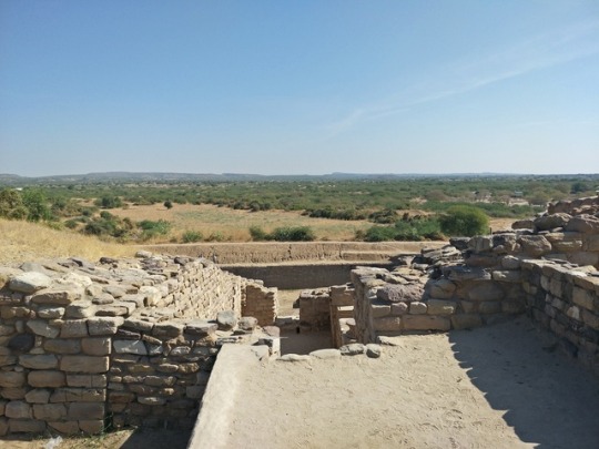
Historical places in Gujarat The state of Gujarat has played a significant role in history. The lands of Gujarat witnessed some brave kings and their rich heritage. Gujarat is also the birthplace of Mahatma Gandhi, the father of the nation, who initiated out various movements for India’s independence from here. The city of Ahmedabad, which is the heart of Gujarat has been recently titled as ‘World Heritage City’ by the UNESCO. Here are some of the places of historical importance and which one must visit and which would give you the feel of the rich ancient heritage and the struggle of Gujarat. Somnath: The Somnath temple is believed to be the first among the 12 Jyotirlingas of Lord Shiva. The shivling at the temple is believed to be ‘swayambhu’ or self-born, manifested in the temple. This temple was destroyed six times and rebuilt every time. The current structure of the temple, seventh reconstruction, is a magnificent edifice built in the Chalukya style of architecture by the master masons of Gujarat, known as Sompuras. Soma, the Moon god, is believed to have lost his luster due to a curse, and he bathed in the Sarasvati River at this site to regain it. The name of the town Prabhas, meaning luster, as well as the alternative names Someshvar and Somnath ("The lord of the moon" or "the moon god") arise from this tradition. You can also visit the beach, and the museum, close to the temple, which exhibits 1638 pieces from 7th to 15th century. Palitana: Located atop the Shetrunjai Hill, Palitana temple is one of the most sacred Jain temples in India and is known for its 3000 brilliantly carved temples. According to the records, there are approximately 108 large temples and 872 small shrines with about 7000 images total that have been built over 900 years from the 11th century by the Jain community. To reach the temple, one will have to climb 3800 steps. For the elder, palanquin (palki) service is easily available. The panoramic view of Palitana unfolds itself as one progresses to the temple. From the top of the temple, you can see the panoramic view of the Gulf of Cambay and countryside. Note: Devotees usually start their climb early in the morning and make their descent by evening as staying at night is not permitted. Dholavira: 250 km from the Bhuj district of Gujarat nestles an ancient town, Dholavira; that throws the light on the Harappan culture and its magnificent civilization. Second largest in India and fifth largest in the Indian sub-continent, this Harappan site the only place that marks the presence of Harappan culture from 2900 BC to 1500 BC. On a trip to Dolavira, you walk can pass through the sun-dried buildings, 5,000-year-old stepwell, ancient reservoirs. To reach Dolavira, you will have to drive for six kilometers from Ahmedabad. Accommodation options are very limited in Dolavira so; you can stay in Ahmedabad or head to Bhuj for the great Rann of Kutch. Laxmi villas palace: Built in 1890 as the private residence of Maharaja Sayajirao Gaekwad III, Laxmi Vilas Palace is indeed one of the grandest structures in India. Sprawling over an area of 700 acres, the palace is believed to be nearly four times the size of Buckingham Palace and features many buildings like Moti Baug Palace, Makarpura Palace, Pratap Vilas Palace and Maharaja Fateh Singh Museum building. It took Robert Fellows Chisholm, the head architect, twelve years to build this grand building. The property also has a Navlakhi stepwell, Maharaja Fatehgarh museum, and a small zoo, which was resting ground crocodiles. Ahmedabad: Finest creations or should I say the major tourists attractions in Gujarat are not only the efforts of years year rulers but also there is a little bit contribution of the citizenry as well. Pols are distinct residential areas that are unique only to Gujarat, and one can find their significant numbers in Ahmedabad. Ahmedabad has been titled the first “Heritage city” in whole India by UNESCO. There are nearly 174 pols in Ahmedabad, each featuring finest lovely wooden windows, brackets, magical balconies, khidkis, and chowks. Earlier pols were the preferred residence across the different sections of Gujarat society for the feeling of society and identity they evoke. Time has bestowed beauty to pol architecture of Gujarat, making them an ornament of world building. Gandhi ashram: Located on the banks of Sabarmati River, this abode of Gandhi is also known as Sabarmati Ashram. This Ashram, originally called Satyagraha Ashram, holds a special mention in the archives of India as a number of freedom movements were planned here between 1917 to 1930. Mahatma Gandhi also trained activists here to join his movements like Swadeshi movements, non-violence and civil disobedience. Gandhi’s poignant, Spartan living quarters are preserved in Sabarmati Ashram, and there’s an open-air museum that presents an informative and moving record of his life and teachings. The Sabarmati Ashram was also the starting point of the very famous and important movement of history, The Salt March to Dandi which played a significant role in leading India towards independence. Sun temple: Built in 1027 AD, Sun temple is one of the surviving Indian shrines dedicated to God Sun and stands as an epitome of the exquisite Hindu temple of Solanki dynasty. The temple is divided into three parts, which are perfectly aligned from east to west, in accordance with the deity passage of the sun. Inside the temple complex, you can see a suryakand or stepwell, prayer hall (also known as Sabhamandapa) supported on 52 pillars and another room (Gudhamandara) that leads to inner sanctum called Garbhagrah. The temple is a sight to behold during the Modhera Dance Festival. Sun temple is located in the Mehsana district of Gujarat, and one can reach by car or bus ride from Ahmedabad. Polo forest: The temples of Polo, located near Vijaynagar, were built between 10th and 15th centuries under the Gurjara-Pratiharas and later the Rathores as a hiding place from enemies, citizens, angry wives, and even from the sun. While there are number of medieval temples in the polo region of this period, the most notable ones are Sarneshwar temple (still in use), Lakha Dera Jain temple and Shiv Shakti Mandir. Structure and design of the temples reveal Islamic traces in the use of domes and lattice screens; it also follows the layout of Traditional Hindu temples. To reach the temples, you can take a bus or private taxi from Ahmedabad, which is hardly 160 kilometers away. Jeeps are also available from Idar, a town in Sabarkantha, which is 56 km from Vijaynagar. Jeeps would take you till the Polo campsite only; thereupon you will have to trek in the forest to explore the temple. There is only one homestay available at the Vijaynagar. Lothal: Somewhere like Dholavira, Lothal is also a significant site of the Indus Valley civilization excavated in India. Here, you can see a tank, which is believed to be a dry dockyard and is connected by the channel to the old course of the Sabarmati River. To know the place better you can also visit the museum, which showcases 5089 products unearthed from the evacuation like terracotta ornaments, shell and ivory objects, replicas of seal and sealings, tools and potteries yielded from excavations, copper and bronze objects animal and human figurines, weights, etc. To reach Lothal, you can hire a taxi from Ahmedabad and go for a long day trip or travel by train till Gandhigram and thereupon take a bus. Champaner: The deserted city of Champaner, a UNESCO world heritage site, is located in the foothills of Pavagadh. With some area perched on a rocky hilltop and bristling with forts, mosques, temples and palaces, Champaner-Pavagadh Archaeological Park looks like something out of a children’s storybook when it’s seen from afar. A major part of Champaner lies in ruins today, with the remains of many old mosques and palaces reflecting a blend of Islamic and Jain tradition. Also here you can find many Chalcolithic Indian Sites from the Stone Age era. Here one can find eleven different types of heritage monuments belonging to 16th century like tombs, gateways, mosques, temples, fortresses and walls, palaces, and pavilions, helical wells, custom houses. Kevda Masjid and Cenotaph, Jami Masjid, Lila Gumbaj Ki Masjid, Pavagadh fort, Lakulisa temple, and Helica Step-well, are some of the famous places to visit in Champaner-Pavagadh Archaeological Park. The Champaner complex is hardly 50 km away from Vadodara, thus, can be a good option for a weekend gateway. Rani ki vav: Rani ki Vav- as the name says this step well was built by Queen (Rani) of Bhimdeva, Udayamanti. Constructed in the 11th century to preserve ground water, Rani ki Vav came into limelight in 1972 when the area was fully earthed. The main highlight of the stepwell is that its walls that are profusely ornamented with figurative motifs and showcases images of various god and goddesses and their consorts from the Hindu Pantheon. The central part of each storey contains the primary sculpture. Winter is the best season to visit Rani ki Vav as you can enjoy the light shows, cultural events and exhibition at the Rani ki Vav Festival. Dwarkadhish temple: One of the four Dhams (divine abodes of India) and Sapata Turis (seven sacred cities), Dwarkadeesh Jagat Mandir doesn’t need any introduction. The word ‘Dwarka; is made of two words- ‘dwara’ meaning road, and ‘ka’ implying eternal significance. Going by the mythological records, Dwarka was the kingdom of Lord Krishna, and he stayed there for quite an extended period. This five storey temple stands on 72 pillars, which according to the science of archeo-astronomy, is some immense significance. The sandstone plinth and walls of the temples are embellished with panels depicting dancers, elephants, musicians and celestial beings. Along with Jagat Mandir, you can also visit the nearby temples like Bet Dwarka, Okha, and shrines dedicated to Rukmini (Lord Krishna’s Wife), Mirabai, Narsinh Mehta and Shank Narayan. Contact justwravel to plan your itinerary for your trip into history. "Kuch din to gujaro Gujarat mein"
0 notes
Text
mp rojgar
Madhya Pradesh (MP) About this sound (help·info), meaning Central Province) is a state in central India. Its capital is Bhopal and the largest city is Indore. Nicknamed the "heart of India" due to its geographical location in India, Madhya Pradesh is the second-largest state in the country by area. With over 75 million inhabitants, it is the fifth-largest state in India by population. It borders the states of Uttar Pradesh to the northeast, Chhattisgarh to the southeast, Maharashtra to the south, Gujarat to the west, and Rajasthan to the northwest. Its total area is 308,252 km². Before 2000, when Chhattisgarh was a part of Madhya Pradesh, Madhya Pradesh was the largest state in India and the distance between the two furthest points inside the state, Singoli and Konta, was 1500 km. The area covered by the present-day Madhya Pradesh includes the area of the ancient Avanti mahajanapada, whose capital Ujjain (also known as Avantika) arose as a major city during the second wave of Indian urbanisation in the sixth century BCE. Subsequently, the region was ruled by the major dynasties of India. By the early 18th century, the region was divided into several small kingdoms which were captured by the British and incorporated into Central Provinces and Berar and the Central India Agency. After India's independence, Madhya Pradesh state was created with Nagpur as its capital: this state included the southern parts of the present-day Madhya Pradesh and northeastern portion of today's Maharashtra. In 1956, this state was reorganised and its parts were combined with the states of Madhya Bharat, Vindhya Pradesh and Bhopal to form the new Madhya Pradesh state, the Marathi-speaking Vidarbha region was removed and merged with the then Bombay State. This state was the largest in India by area until 2000, when its southeastern Chhattisgarh region was made a separate state. In recent years, the state's GDP growth has been above the national average. Rich in mineral resources, MP has the largest reserves of diamond and copper in India. More than 30% of its area is under forest cover. Its tourism industry has seen considerable growth, with the state topping the National Tourism Awards in 2010–11.
History
Isolated remains of Homo erectus found in Hathnora in the Narmada Valley indicate that Madhya Pradesh might have been inhabited in the Middle Pleistocene era. Painted pottery dated to the later mesolithic period has been found in the Bhimbetka rock shelters.Chalcolithic sites belonging to Kayatha culture (2100–1800 BCE) and Malwa culture (1700–1500 BCE) have been discovered in the western part of the state.
The city of Ujjain arose as a major centre in the region, during the second wave of Indian urbanisation in the sixth century BCE. It served as the capital of the Avanti kingdom. Other kingdoms mentioned in ancient epics — Malava, Karusha, Dasarna and Nishada — have also been identified with parts of Madhya Pradesh. Chandragupta Maurya united northern India around 320 BCE, establishing the Mauryan Empire, which included all of modern-day Madhya Pradesh. Ashoka the greatest of Mauryan rulers brought the region under firmer control. After the decline of the Maurya empire, the region was contested among the Sakas, the Kushanas, the Satavahanas, and several local dynasties during the 1st to 3rd centuries CE. Heliodorus, the Greek Ambassador to the court of the Shunga king Bhagabhadra erected the Heliodorus pillar near Vidisha. Ujjain emerged as the predominant commercial centre of western India from the first century BCE, located on the trade routes between the Ganges plain and India's Arabian Sea ports. The Satavahana dynasty of the northern Deccan and the Saka dynasty of the Western Satraps fought for the control of Madhya Pradesh during the 1st to 3rd centuries CE. The Satavahana king Gautamiputra Satakarni inflicted a crushing defeat upon the Saka rulers and conquered parts of Malwa and Gujarat in the 2nd century CE.Subsequently, the region came under the control of the Gupta empire in the 4th and 5th centuries, and their southern neighbours, the Vakataka's. The rock-cut temples at Bagh Caves in the Kukshi tehsil of the Dhar district attest to the presence of the Gupta dynasty in the region, supported by the testimony of a Badwani inscription dated to the year of 487 CE.The attacks of the Hephthalites or White Huns brought about the collapse of the Gupta empire, which broke up into smaller states. The king Yasodharman of Malwa defeated the Huns in 528, ending their expansion. Later, Harsha (c. 590—647) ruled the northern parts of the state. Malwa was ruled by the south Indian Rashtrakuta Dynasty from the late 8th century to the 10th century. When the south Indian Emperor Govinda III of the Rashtrakuta dynasty annexed Malwa, he set up the family of one of his subordinates there, who took the name of Paramara. The Medieval period saw the rise of the Gurjar clans, including the Paramaras of Malwa and the Chandelas of Bundelkhand. The Chandellas built the majestic Hindu-Jain temples at Khajuraho, which represent the culmination of Hindu temple architecture in Central India. The Gurjara-Pratihara dynasty also held sway in northern and western Madhya Pradesh at this time. It also left some monuments of architectural value in Gwalior. Southern parts of Madhya Pradesh like Malwa were several times invaded by the south Indian Western Chalukya Empire which imposed its rule on the Paramara kingdom of Malwa.[14] The Paramara king Bhoja (c. 1010–1060) was a renowned polymath. The small Gond kingdoms emerged in the Gondwana and Mahakoshal regions of the state. Northern Madhya Pradesh was conquered by the Turkic Delhi Sultanate in the 13th century. After the collapse of the Delhi Sultanate at the end of the 14th century, independent regional kingdoms re-emerged, including the Tomara Gurjar kingdom of Gwalior and the Muslim Sultanate of Malwa, with its capital at Mandu. The Malwa Sultanate was conquered by the Sultanate of Gujarat in 1531. In the 1540s, most parts of the state fell to Sher Shah Suri, and subsequently to the Hindu king Hemu. Hemu, who had earlier served as the General of the Suri dynasty, operated from the Gwalior Fort during 1553–56 and became the rural of Delhi as a Vikramaditya king winning 22 battles continuously from Bengal to Gujrat and defeating Akbar's forces in Battle of Delhi 1556 on 7 October 1556. However, he chose Delhi as his capital after his formal Coronation and left Gwalior. After Hemu's defeat in the Second Battle of Panipat in 1556 to Akbar, most of Madhya Pradesh came under the Mughal rule. Gondwana and Mahakoshal remained under the control of Gond kings, who acknowledged Mughal supremacy but enjoyed virtual autonomy. The Mughal control weakened considerably after the death of Emperor Aurangzeb in 1707. Between 1720 and 1760, the Marathas took control of most of Madhya Pradesh, resulting in the establishment of semi-autonomous states under the nominal control of the Peshwa of Pune: the Holkars of Indore ruled much of Malwa, Puars ruled Dewas and Dhar, the Bhonsles of Nagpur dominated Mahakoshal-Gondwana area, while the Scindias of Gwalior controlled the northern parts of the state. The most notable Maratha rulers of the region were Mahadji Shinde, Ahilyabai Holkar and Yashwantrao Holkar. Besides these, there were several other small states, including Bhopal, Orchha, and Rewa. The Bhopal state, which paid tribute to both the Marathas and the Nizam of Hyderabad, was founded by Dost Mohammed Khan, a former General in the Mughal army. After the Third Anglo-Maratha War, the British took control of the entire region. All the sovereign states in the region became princely states of British India, governed by the Central India Agency. The Mahakoshal region became a British province: the Saugor and Nerbudda Territories. In 1861, the British merged the Nagpur Province with the Saugor and Nerbudda Territories to form the Central Provinces. During the 1857 uprising, rebellions happened in the northern parts of the state, led by leaders like Tatya Tope. However, these were crushed by the British and the princes loyal to them. The state witnessed a number of anti-British activities and protests during the Indian independence movement.[15] Several notable leaders such as Chandra Shekhar Azad, B. R. Ambedkar, Shankar Dayal Sharma and Atal Bihari Vajpayee were born in what is now Madhya Pradesh. After the independence of India, Madhya Pradesh was created in 1950 from the former British Central Provinces and Berar and the princely states of Makrai and Chhattisgarh, with Nagpur as the capital of the state. The new states of Madhya Bharat, Vindhya Pradesh, and Bhopal were formed out of the Central India Agency. In 1956, the states of Madhya Bharat, Vindhya Pradesh, and Bhopal were merged into Madhya Pradesh, and the Marathi-speaking southern region Vidarbha, which included Nagpur, was ceded to Bombay state. Bhopal became the new capital of the state. In November 2000, as part of the Madhya Pradesh Reorganization Act, the southeastern portion of the state split off to form the new state of Chhattisgarh.
Geography Location in India Madhya Pradesh literally means "Central Province", and is located in the geographic heart of India, between latitude 21.2°N-26.87°N and longitude 74°02'-82°49' E. The state straddles the Narmada River, which runs east and west between the Vindhya and Satpura ranges; these ranges and the Narmada are the traditional boundary between the north and south of India. The highest point in Madhya Pradesh is Dhupgarh, with an elevation of 1,350 m (4,429 ft). The state is bordered on the west by Gujarat, on the northwest by Rajasthan, on the northeast by Uttar Pradesh, on the east by Chhattisgarh, and on the south by Maharashtra.
Climate Madhya Pradesh has a subtropical climate. Like most of north India, it has a hot dry summer (April–June), followed by monsoon rains (July–September) and a cool and relatively dry winter. The average rainfall is about 1,371 mm (54.0 in). The southeastern districts have the heaviest rainfall, some places receiving as much as 2,150 mm (84.6 in), while the western and northwestern districts receive 1,000 mm (39.4 in) or less.
Ecology According to the 2011 figures, the recorded forest area of the state is 94,689 km2 (36,560 sq mi) constituting 30.72% of the geographical area of the state It constitutes 12.30% of the forest area of India. Legally this area has been classified into "Reserved Forest" (65.3%), "Protected Forest" (32.84%) and "Unclassified Forest" (0.18%). Per capita forest area is 2,400 m2 (0.59 acres) as against the national average of 700 m2 (0.17 acres). The forest cover is less dense in the northern and western parts of the state, which contain the major urban centres. Variability in climatic and edaphic conditions brings about significant difference in the forest types of the state. The major types of soils found in the state are: Black soil, most predominantly in the Malwa region, Mahakoshal and in southern Bundelkhand Red and yellow soil, in the Baghelkhand region Alluvial soil, in Northern Madhya Pradesh Laterite soil, in highland areas Mixed soil, in parts of the Gwalior and Chambal divisions
Flora and fauna Main article: Flora and fauna of Madhya Pradesh Madhya Pradesh is home to nine National Parks; Bandhavgarh National Park, Kanha National Park, Satpura National Park, Sanjay National Park, Madhav National Park, Van Vihar National Park, Mandla Plant Fossils National Park, Panna National Park, and Pench National Park.[18] There are also a number of nature reserves, including Amarkantak, Bagh Caves, Balaghat, Bori Natural Reserve, Ken Gharial, Ghatigaon, Kuno Palpur, Narwar, Chambal, Kukdeshwar, Narsinghgarh, Nora Dehi, Pachmarhi, Panpatha, Shikarganj, Patalkot, and Tamia. Pachmarhi Biosphere Reserve in Satpura Range, Amarkantak biosphere reserve and Panna National Park are three of the 18 biosphere reserves in India. Most of them are located in the Eastern Madhya Pradesh near Jabalpur.
More Details Check Online
0 notes
Photo


Devī Mahākālī Cāmuṇḍeśwarī
The fierce aspect of the Mother Goddess, slayer of the rākṣasas Caṇḍa and Muṇḍa – whence the appellation Cāmuṇḍeśwarī. Depicted here sitting astride a corpse.
High relief in a niche outside the Sahastrabāhu Temple, Nāgdā, near Udaipur
Granite circa 10th Century CE, Gurjara Pratihara Era
#Devī Mahākālī Cāmuṇḍeśwarī#Mahākālī#Maha Kali#Cāmuṇḍeśwarī#Chamundeshwari#Hinduism#Hindu Art#Hindu Sculpture#Gurjara Pratihara Era
41 notes
·
View notes
Photo


Devī Durgā Mahiśāsuramardinī
The Goddess Durgā slaying the buffalo-demon Mahiśāsura. The iconography is highly dynamic, the imagery conveying a sense of motion. The great goddess has the demon’s buffalo body pinned down underfoot and its head is cut, but Mahiśāsura emerges in human form to continue fighting.
Niche outside the central maṅḍapa, Ambikāmātā Temple, Jagat Rājasthān
969 CE, Gurjara Pratihāra Era
#Devī Durgā Mahiśāsuramardinī#Devī Durgā#Devī Mahiśāsuramardinī#Durga#Mahishasuramardini#Shakti#Ambika#Mother Goddess#Hinduism#Hindu Art#Shaktism#Gurjara Pratihara Era
101 notes
·
View notes
Photo


Devī Maheśwarī
One of the saptamātrikās or seven mothers depicted wielding the trident and with the siṁha vahana.
Sub shrine abutting the Ambikā Mātā temple, Jagat
Gurjara Pratihāra Era, 969 CE
#Devī Maheśwarī#Maheshwari#Saptamātrikā#Saptamatrika#Mother Goddess#Hinduism#Hindu Art#Hindu Sculpture#Gurjara Pratihara Era
32 notes
·
View notes
Photo


Śrī Umā-Maheśwara
Gañgodbhava Kuṇḍ, Āhar near Udaipūr, circa 10th Century CE
Gurjara-Pratihāra Era
17 notes
·
View notes
Photo


Garuda 10th century, Gurjara-Pratihara Era. Rajasthan, India. 45cm. Now in National Museum, New Delhi
Image of winged a Garuda in human form, which is carved in the round and shown kneeling on a decorative base which having a tenon at the bottom. His right leg is raised and thrown backwards and the left raised and bent at the knee. His weight is taken on the right knee and left foot. His right hand with palm facing front is placed on the head, while in the left he folds a serpent. He wears ear-rings, necklace, armlets, bangles, sarpa-yajnopavita and a lower garment. (via Museums of India - National Portal and Digital Repository)
50 notes
·
View notes
Photo

Madanika - Surasundari
The celestial beauty, panel outside the Ambika Mata Temple, Jagat
Gurjara Pratihara Era, circa 960 CE
58 notes
·
View notes