#Grand Canyon trails
Explore tagged Tumblr posts
Text

Bright Angel Trail, Grand Canyon, Arizona. Hardest hike of my life.
#hiking#trail#footpath#hiking trail#bright Angel trail#grand canyon#arizona#arizona hiking#grand canyon trails
2 notes
·
View notes
Text
Unleash Your Adventure Spirit: The Ultimate Hiking Guide to Desert View Area, Grand Canyon National Park
Get ready for an extraordinary adventure as we take you through the most remarkable hikes and trails of the Desert View Area in the majestic Grand Canyon National Park! This guide is your quintessential companion to explore the breathtaking beauty of the wild, the panoramic views of the hued canyon walls, and the serenity of the desert landscapes. Whether you’re a seasoned hiker or a newbie, this…

View On WordPress
#adventurous trails#best hikes#breathtaking hikes#Desert View Area#Desert View trails#extraordinary hikes#Grand Canyon exploration#Grand Canyon hikes#Grand Canyon National Park#Grand Canyon trails#hiking adventure#hiking experience#hiking guide#hiking journey#hiking tips#hiking trails#National Park hiking#nature exploration#nature&039;s beauty#Outdoor Adventures#sunset hikes#Trail Guide#wilderness hikes
0 notes
Text


#nature#hiking#landscape#Grand Canyon#Arizona#desert#southwest#american southwest#hermit trail#hermit camp#hermit creek#creek#waterfall
132 notes
·
View notes
Text

A couple stops to take in the immense view of the Grand Canyon on Bright Angel Trail at Plateau Point.
Arizona
1989
#vintage camping#campfire light#grand canyon#arizona#bright angel trail#hiking#history#camping#outdoors#1980s
195 notes
·
View notes
Text

Dripping Springs Trail.
Grand Canyon National Park, Arizona
2018
#trail#hiking#landscape#landscape photography#national park#national park service#grand canyon#travel#original photography#photographers on tumblr#photography#lensblr#nature hikes#arizona#wanderingjana
40 notes
·
View notes
Text

Reaching this Grand Canyon location requires a rugged 10-mile hike on the Hermit Trail and Boucher Trail, built by "The Hermit" himself — Louis Boucher — in the late 1800s.
📸 by Jake Case - Mountain Tripper
Boucher lived in the Canyon before it became a national park, operating mostly unsuccessful mine claims and eventually leading tourists down his trails as a guide.At this location just past the end of the what we now call the Boucher Trail, he built a small cabin, the ruins of which can still be found to this day. On the topographic map of the area a small mining prospect is marked, which I assume was Boucher's purpose for setting up a camp here.
Regardless of the fascinating bits of history, this slice of Grand Canyon is stunningly beautiful. Marsh Butte towers majestically overhead, Boucher Creek's spring-fed waters bubble through the canyon bottom, and brittlebush bloom on perfect spring days like the one I captured here. If you choose to venture down the Boucher Trail, you'll need to secure an overnight backpacking permit from the Grand Canyon backcountry office. The trail is steep, rocky, and sometimes completely washed out from storms. Self-reliance is a must for modern hikers traversing this remote stretch of Grand Canyon, but well worth a visit for those willing to rough it.
#Jake Case#Mountain Tripper#Grand Canyon#Boucher Trail#Amazing#Beautiful#Nature#Travel#Adventure#Photography
30 notes
·
View notes
Text
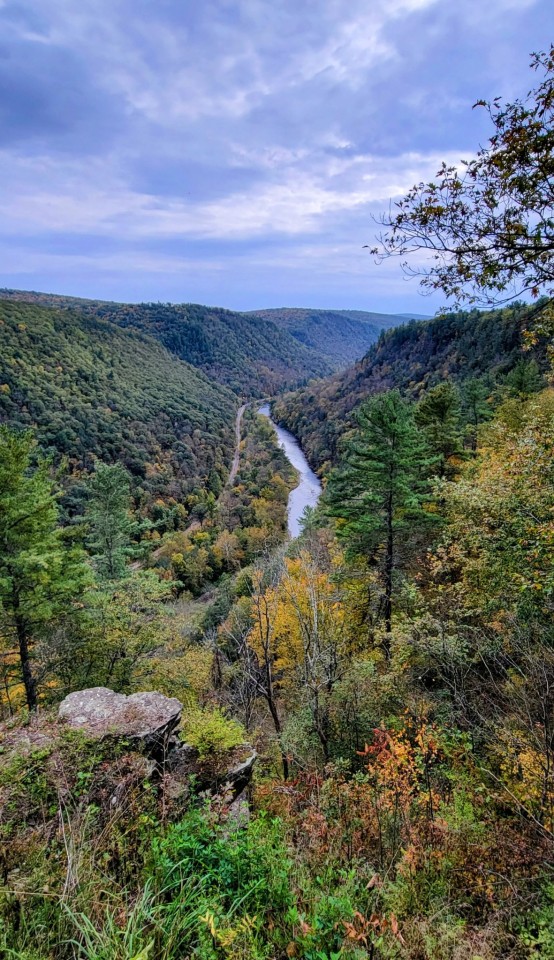
Pine Creek Gorge, aka Pennsylvania Grand Canyon. Biked 18 miles on the rail trail, creekside; then drove up to Colton Point for the view. Not much color yet, but always beautiful, no matter the season.
#lunaladee photos#pine creek gorge#'PA grand canyon'#PA Wilds#biking#rail trail#10.12.23#original photography#photographers on tumblr
40 notes
·
View notes
Text


Pics from my backpacking trip into the Grand Canyon!
#I was carried the whole way :)#Grand Canyon#north kaibab trail#rim to rim#hiking#backpacking#wolf plush#wolf lore
2 notes
·
View notes
Text

View from the Nankoweap trail. Michael Foushee
10 notes
·
View notes
Text

Get better views & have longer stays with an #adventurevan from Hawkes Outdoors in #Texas 210-251-2882. Quick #finance options and we take trade-ins.
#camping#texas#hawkesoutdoors#overland#boerne#austin#san antonio#seguin#vans#adventure van#sprintervan#outdoors#grand canyon#views#scenic#travel#trails#explore
2 notes
·
View notes
Text

Nothing like being on the rim of Grand Canyon.
4 notes
·
View notes
Text
Ultimate Hiking Guide for the South Rim, Grand Canyon National Park
Embark on an unforgettable journey through the awe-inspiring landscapes of the South Rim, Grand Canyon National Park. This guide is meticulously curated to assist all levels of adventurers to navigate through the enchanting trails, providing insider tips and advice for optimal viewing spots and safety. Unleash your inner explorer and marvel at the stunning vistas that this iconic American…

View On WordPress
#Grand Canyon National Park#Grand Canyon trails#hiking boot recommendations#hiking guide#hiking proficiency#hiking tips#National Parks USA#nature enthusiast#Nature Trails#outdoor adventure#park preservation#safety advice#Scenic hikes#South Rim hiking#travel advice#wilderness exploration#wildlife viewing
1 note
·
View note
Text


#nature#hiking#landscape#grand canyon#hermit trail#arizona#desert#southwest#american southwest#lens flare
42 notes
·
View notes
Text
Letchworth State Park
Spanning 14,427 acres in New York, Letchworth State Park, known as the “Grand Canyon of the East,” is a haven for equestrians. With 66 miles of hiking trails, over 17 miles are dedicated to horseback riding, offering breathtaking views of gorges, forests, and waterfalls. The park provides diverse experiences with the bustling West Side, featuring attractions and a $10 fee, and the tranquil East…

View On WordPress
#Equestrian Trails#Equestrian Travel#Grand Canyon of the East#Horse Riding Parks#Horseback Riding New York#letchworth state park#Nature Parks USA#NY Horse Trails#NY State Parks#Outdoor Adventure NY#Rochester Horse Trails#Rochester Horseback Riding#Scenic Riding Trails#Upstate New York Attractions
3 notes
·
View notes
Video
I Can't Believe...But I Do Now! (Grand Canyon National Park) by Mark Stevens Via Flickr: A view looking to the north while at the overlook at Mather Point in Grand Canyon National Park. I pulled in on the focal length and angled my Nikon SLR camera slightly downward in order to capture a more sweeping view across the eroded formations, temples, and buttes. One can then more easily see the deep canyons carved by the Colorado River and other tributaries flowing through the national park. The North Rim would also be easily seen looking in a straight-ahead direction.
#Nikon D850#Azimuth 15#Looking North#Arizona Petrified Forest National Park and Sedona#Day 4#Grand Canyon National Park#Rim Trail#Mather Point#Erosion#Canyon#Eroded Canyon#Striation of Rock Layers#Kaibab Limestone#Colorado Plateau#Layered Rock#Plateaus#Plateau#Gorge#Cliffs#Colorful Landscape#Intricate Landscape#Exposed Layers of Rock#Intermountain West#Grand Canyon Plateaus#Coconino Plateau#Kaibab Plateau#High Desert#Blue Skies#DxO PhotoLab 4 Edited#Landscape
6 notes
·
View notes
Text
This New Park Gives Different Views of the Grand Canyon—with No Crowds
These sacred Indigenous lands in Arizona just got government protection. Here’s how to explore their hikes, wildlife, and impressive vistas.
— By Joe Yogerst | September 1, 2023

Red Butte, which the Havasupai people call Wii'i Gdwiisa (“Clenched Fist Mountain”), is one of many sacred Indigenous sites within Arizona’s new Baaj Nwaavjo I’tah Kukveni Grand Canyon National Monument. Named a national monument by President Joseph Biden in August 2023, the one-million-acre wilderness offers hiking, backcountry camping, and views of the Grand Canyon without the crowds. Photograph By Taylor McKinnon, Center For Biological Diversity
Grand Canyon National Park draws 4.7 million visitors a year to the northwest corner of Arizona to hike, camp, or watch wildlife. But most of them don’t realize that the lands within and surrounding the park are sacred to the region’s 12 Indigenous tribes, which include the Havasupai, Hopi, Navajo, and several bands of Paiute.
That changed on August 8 when President Joseph Biden signed a decree creating the Baaj Nwaavjo I’tah Kukveni—Ancestral Footprints of the Grand Canyon National Monument. Sprawling across more than 960,000 acres directly north and south of the national park, the new monument offers more rugged, less crowded recreation than its neighbor. It also provides a view of the landscape through Indigenous eyes.
“Baaj nwaavjo in Havasupai means ‘where the ancient people roamed,’” says Carletta Tilousi, coordinator of the Grand Canyon Tribal Coalition. “I’tah kukveni is the Hopi translation of ‘ancestral footsteps’. This reaffirms their creation stories.”
Here’s how the monument came to be, and how to explore it.
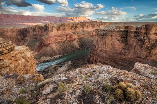
Baaj Nwaavjo I’tah Kukveni yields views of the Colorado River and Grand Canyon from a different perspective. Photograph By Amy S. Martin
How to Make a National Monument
It took two million years for the Grand Canyon itself to form and around 40 years for Baaj Nwaavjo I’tah Kukveni to become reality. “The protection for these lands is something the tribes have focused on since as far back as the 1980s,” says Amber Reimondo of the Grand Canyon Trust, a nonprofit devoted to preserving the region.
Many of these Indigenous people were expelled from their territory when Grand Canyon National Park was established in 1919. They campaigned for decades to receive stronger protection for their lands around the park, overcoming entities that wanted fewer legal obstacles to development and mining. After President Biden’s election in 2020, the 12 tribes formed a coalition which led to the lands receiving federal status.
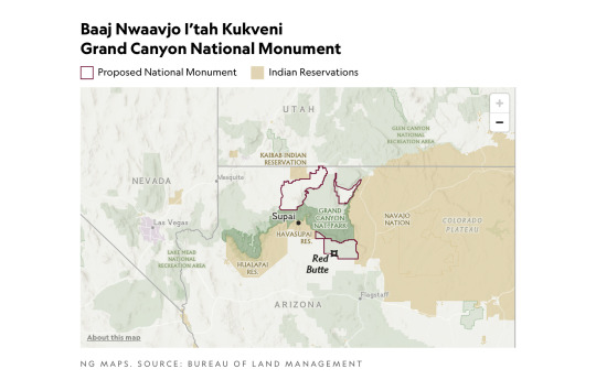
Though the National Park Service oversees Grand Canyon National Park, monuments such as Baaj Nwaavjo I’tah Kukveni are run by the U.S. Forest Service (USFS) and the Bureau of Land Management (BLM). Monuments generally have fewer restrictions regarding their use (e.g., sometimes hunting or logging is allowed), as well as fewer facilities for visitors.
Fewer Amenities, Fewer Crowds
Like many national monuments, Baaj Nwaavjo I’tah Kukveni exudes raw nature. It has no bathrooms or visitor center; access is primarily via dirt roads or rough trails; you’ll need a four-wheel-drive to reach many sections of the park.
What it offers is solitude and peace amid the forests and grasslands of northern Arizona. You can gaze at the Grand Canyon without thousands of other people jostling for the same space, hike trails where yours are the only footsteps, and make camp at secluded spots. Plus you might encounter wildlife such as elk, black bear, mule deer, birds, or bison.
That solitude is also important to the Indigenous people. Tilousi says that when she visits the busy South Rim inside Grand Canyon National Park, “It’s very difficult for me to find a spot where I can offer prayers and offerings in a quiet way.” She feels that won’t be an issue in the off-the-beaten-track lands of the new monument.

Native plants including yucca flourish within Baaj Nwaavjo I'teh Kukveni National Monument. Photograph By Amy S. Martin
Exploring the Monument
The vast wilderness of Baaj Nwaavjo I’tah Kukveni is divided into three distinct sections or parcels, each with its own appeal.
The southernmost section, the Tusayan Ranger District/South Parcel, is the easiest to explore. Comprising 330,000 acres within the Kaibab National Forest, its pine woodlands and sagebrush prairie are accessible via Forest Service roads or Sections 35 through 37 of the Arizona Trail, an 800-mile hiking route stretching across the entire state.
The South Parcel also shows signs of human life, including the rusty hangar of the 1920s Red Butte Airfield and the 80-foot-tall Grandview Lookout Tower, which you can climb for views of the Colorado Plateau and the Grand Canyon.
The other sections of the monument, Kanab Plateau/Northwest Parcel and Rock House Valley/Northeast Parcel, are located beyond the North Rim section of Grand Canyon National Park.
“It's a big, remote wilderness,” says Michael Cravens, advocacy and conservation director of the Arizona Wildlife Federation. “I’ve never in my life been somewhere with night skies that spectacular.” But he cautions visitors “to be careful and prepared” for the extreme weather and topography. You can reach the northern parcels on BLM roads south of U.S. Highway 89A.

The vast House Rock Valley stretches through a portion of the new national monument. Photograph By Taylor McKinnon, Center For Biological Diversity
Stretched across the Kanab Plateau and Antelope Valley, the Kanab Plateau section has hiking routes through spectacular side canyons and to panoramic views such as Gunsight Point.
The Hack Trail drops down into the Kanab Creek Wilderness with its enormous red-rock canyons, a landscape almost as impressive as the Grand Canyon itself. Experienced hikers can continue down Kanab Creek to the Colorado River or along other trails to vertiginous overlooks along the North Rim.
Set beneath the Vermilion Cliffs National Monument, the Rock House Valley section of Baaj Nwaavjo I’tah Kukveni tumbles across sagebrush flats to the edge of Marble Canyon. Rugged hiking trails here include the Soap Creek Trail, which winds down from the Rapids/Badger Camp Overlook to a primitive campsite near the river.
Rough roads lead south to viewpoints for Rider Canyon, South Canyon, and other offshoots of the Grand Canyon. Here, you might even spot the North Rim’s resident bison herd, brought to the Arizona Strip in 1906 by Charles “Buffalo” Jones as part of efforts to save the species.
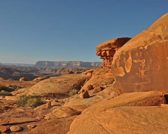
Ancient rock art can be spotted in the Kanab Creek Wilderness portion of Baaj Nwaavjo I’tah Kukveni National Monument. Photograph By Natpar Collection, Alamy Stock Photo

The Havasupai Indian Reservation in Arizona, which includes the Havasu Waterfall—part of the Havasupai Falls—is the current home of the Havasupai people. After the Grand Canyon became a national park, they were forcibly removed from their traditional homelands in the canyon and in nearby lands that will be part of the new national monument. Photograph By Mike Theiss National Geographic Image Collection
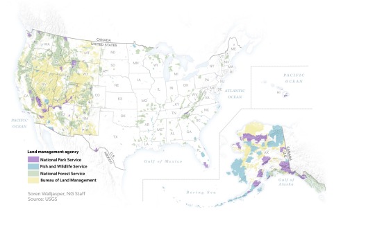
1 Million Acres of ‘Sacred’ Land Near Grand Canyon are Receiving New Protections! The designation of the land as a national monument, confirmed to National Geographic this week by the White House, will prevent new uranium mines and protect historically significant tribal lands.
#United States 🇺🇸 National Parks#New Park#Grand Canyan#Indigenous Lands#Arizona#Wildlife#Red Butte | Clenched Fist Mountain#Arizona | Baaj Nwaavjo I’tah Kukveni Grand Canyon National Monument#Center For Biological Diversity#President Joe Biden#Carletta Tilousi | Coordinator | Grand Canyon Tribal Coalition#Ancestral Footprints#Colorado River#Amber Reimondo | Grand Canyon Trust | Non-profit | Region Preservation#National Park Service#U.S. Forest Service (USFS) | The Bureau of Land Management (BLM).#Wildlife | Elk | Black Bear 🐻 | Mule | Deer 🦌 | Birds 🦅 | Bison 🦬#Hike Trails#Off-The-Beaten-Track Lands#Tusayan Ranger District | South Parcel#Kaibab National Forest 🌳#Colorado Plateau#Kanab Plateau/Northwest Parcel | Rock House Valley/Northeast Parcel#U.S. Highway 89A#Michael Cravens | Arizona Wildlife Federation#Kanab Plateau | Antelope Valley#Gunsight Point#Hack Trail#Vermilion Cliffs National Monument#Rock House Valley
3 notes
·
View notes