#Ganga and Brahmaputra
Explore tagged Tumblr posts
Visit Tumblr Blog
Explore Tumblr blogs with no restrictions, modern design and the best experience.
Last Seen Tumblr Blogs


Fun Fact
There are dozens of funny blogs to kill time on Tumblr.
Link

India's rivers can be broadly categorized into four types based on their source - Himalayan rivers, coastal rivers, Deccan rivers, and inland drainage rivers. The Himalayan rivers, like the Ganga, Yamuna, and Brahmaputra, originate in the Himalayas and flow through the northern and eastern parts of India. The coastal rivers, like the Godavari, Krishna, and Kaveri, originate in the Western Ghats and flow towards the eastern coast of India.
https://www.indianetzone.com/2/indian_rivers_lakes.htm
2 notes
·
View notes
Text
#Indus River#Ganga River System#Brahmaputra River System#Drainage system based on origin#Contribution Percentage various River’s water#Differences Betweeen the river which drain into Bay of Bengal and which drain into Arabian Sea#Indus River System
0 notes
Text
https://trendingnews724.com/web-stories/bharat-ki-sabhi-nadiyo-me-yah-ek-matra-purush-nadi/
0 notes
Text


Folk Goddesses of Bengal
বনবিবি (rom. Bonbibi)
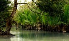
In the sparse region that confines the largest mangrove forest on Earth is the Sundarbans. The delta of the mighty Ganga, Brahmaputra and the sisterly Meghna is the region of co-existence between man and the wild. Bonbibi is the protectress of the forest, the wild, the bees, the birds, and the people. She represents the bounty of the forest, and her foe the tiger king Dakhin Rai, the hazards of the same. Her fierce battle with the evil Dakhin Rai has been inspirations for many. She doesn't differentiate between who pray to her, the hindu, muslim, christian. Just as the forest doesn't differentiate between who it welcomes, or who it discards. The forest, and the rivers form the livelihood for the forest dwellers, who pray to the mistress of bees, tigers and the creatures of the forest before embarking of their daily hunt for bread. However, the goddess has one condition, for she is the mother of all of the forest,
"Take what you require, not more not less. Don't harm the forest, and no harm must come to you."
A simple norm by which those who enter the delta, must abide by. A simple norm, which we all must abide by.
(picture credit to the owners)
#desi academia#desi aesthetic#desi culture#desiblr#vedic culture#desi dark academia#bengblr#sundarbans#rivers#ganga#hindu mythology#hindu culture#hinduism#bengali#hindublr#desi tumblr#bonbibi
82 notes
·
View notes
Note
Imma trouble you by asking for sum Sindhu and Brahmaputra BF hcs.
They kinda hated each other at first.. Haha.
���Rivals to lovers✨
"I'M ONE OF THE OLDEST AND THE SECOND MOST IMPORTANT RIVER SYSTEM! " Brahmaputra.
"THIS SUBCONTINENT GOT IT'S NAME LITERALLY FROM ME. " Sindhu.
Ganga - literally everyone's friend - decided to set them up on a blind date.
The date went surprisingly well. Brahmaputra and Sindhu both actually got to know that they are well.. old.. ancient.. And also ✨smart✨
They like to go on dates along the hilly plains. Brahmaputra likes to take Sindhu on vacation to Bangladesh, Tibet etc cuz he's social and has friends there.
Sindhu on the other hand dwells in India and Pakistan and likes to show Brahmaputra around the lands he used to water.
Sindhu is one emotionally unstable bitch and Brahmaputra is there to comfort him. (Years of invasions affected Sindhu greatly).
BRAHMAPUTRA IS THE SOFTIE TOP AND SINDHU IS THE BITCHY BOTTOM STFU.
Brahmaputra who is an active part of the popular Himalayan river besties group encourages Sindhu to also talk and socialize with his childhood friends - Ravi, Chenab, Satluj and others.
Brahmaputra is gay and Sindhu is pansexual.
34 notes
·
View notes
Text


Mega Schemes
Huge hydraulic schemes are made possible by advanced modern civil engineering techniques. They require vast international contracts that are only possible at the level of central governments, international free floating capital and supranational government organisations. The financiers borrow money and lend it at commercial rates, so they favour largescale engineering projects that promise increasing production for export markets at the expense of local subsistence economies, with disastrous social and environmental effects. Cash crops destroy settled communities and cause pollution of soil and water. For instance, Ethiopia’s Third Five-Year Plan brought 60% of cultivated land in the fertile Awash Valley under cotton, evicting Afar pastoralists onto fragile uplands which accelerated deforestation and contributed to the country’s ecological crisis and famine. There’s a vicious circle at work. Development needs money. Loans can only be repaid through cash crops that earn foreign currency. These need lots more water than subsistence farming. Large hydraulic schemes to provide this water are development. Development needs money. And so it goes.
Large-scale projects everywhere are the consequence and justification for authoritarian government: one of America’s great dam-building organisations is the US Army Corps of Engineering. Stalin’s secret police supervised the construction of dams and canals. Soldiers such as Nasser of Egypt and Gadafi of Libya and military regimes in South America have been prominent in promoting such projects. Nasser built the Anwar High dam in 1971. The long-term consequences have been to stop the annual flow of silt onto delta land, requiring a growing use of expensive chemical fertilisers, and increased vulnerability to erosion from the Mediterranean. Formerly the annual flooding washed away the build-up of natural salts; now they increase the salt content of irrigated land. The buildup of silt behind the dam is reducing its electricity generating capacity; the lake is also responsible for the dramatic increase in water-borne diseases. Nationalism leads to hydraulic projects without thought to what happens downstream in other countries. The 1992 floods of the Ganga-Brahmaputra-Barak system killed 10,000 people. 500m people live in the region, nearly 10% of the world’s population, and they are constantly at risk from water exploitation and mismanagement. Technological imperialism has replaced the empire building of the past: large-scale hydro projects are exported to countries despite many inter-related problems – deforestation, intensive land use and disputes and so on. Large-scale water engineering projects foment international disputes and have become economic bargaining counters, for example the Pergau dam in Malaysia. The British Government agreed to spend £234m on it in 1989 in exchange for a £1.3bn arms deal. In 1994 the High Court ruled that the aid decision was unlawful but these kinds of corrupt deals continue.
In Sri Lanka the disruption caused by the Mahawelli dams and plantation projects resulted in the forcible eviction of 1 million people and helped maintain the insurgency of the Tamil Tigers that resulted in thousands of deaths as they fought government forces from the late 1980s onwards. In 1993 the Marsh Arabs of southern Iraq were threatened by Saddam Hussein’s plans to drain the area – the most heavily populated part of the region. Many of the 100,000 inhabitants fled after being warned that any opposition risked death. Selincourt estimated that 3 million people would lose their homes, livelihoods, land and cultural identity by giant dam projects in the 1990s. The Kedung Ombo dam (Indonesia) displaced 25,000; the Akasombo dam (Ghana) 80,000; Caborra Bassa (South Africa) 25,000. Three dams in Laos alone will have displaced 142,000 people. The proposed Xiao Langdi dam in China would displace 140,000; the Three Gorges project 1.1 million people. Only war inflicts a similar level of human and environmental destruction, yet large dam projects have a chronic record in delivering water and power, or eliminating flooding in downstream valleys.
#freedom#ecology#climate crisis#anarchism#resistance#community building#practical anarchy#practical anarchism#anarchist society#practical#revolution#daily posts#communism#anti capitalist#anti capitalism#late stage capitalism#organization#grassroots#grass roots#anarchists#libraries#leftism#social issues#economy#economics#climate change#climate#anarchy works#environmentalism#environment
2 notes
·
View notes
Text
A large section of Bangladesh’s people has been exhibiting strong anti-India sentiments over the past few years, owing mostly to the public perception that India was helping Prime Minister Sheikh Hasina’s regime hold power by hook or crook. After floods in northeast India’s Tripura state spilled over to Bangladesh on August 21, India quickly emerged as the villain.
The interim government in Bangladesh and its political establishment blamed India for releasing water from a dam in Tripura without notifying Bangladesh, while students staged protests on many university campuses chanting anti-India slogans.
“India displayed inhumanity by opening the dam without warning,” Nahid Islam, one of the two student representatives in Bangladesh’s interim government headed by Peace Nobel Laureate economist Muhammad Yunus, told journalists in Dhaka.
In a Facebook post, he wrote: “The generation that understands India as our enemy is made of the best children of the nation.” It is an often-repeated quotation from one of Bangladesh’s legendary politicians, the late Maulana Abdul Hamid Khan Bhashani, one of the first Bangladeshi politicians to allege that India was depriving Bangladesh of waters from transboundary rivers.
India and Bangladesh share 54 transboundary rivers, including the Ganga (Padma), Teesta, and Brahmaputra (Jamuna).
Islam, the student representative in the Yunus administration, even accused India of “water terrorism” in a social media post. In another post, Islam wrote, “India can be fixed if we give the Teesta project to China.”
Teesta water sharing has long been an issue of conflict and tension between India and Bangladesh. The Diplomat had earlier reported how China was trying to utilize to its advantage India’s indecisiveness in accepting Bangladesh’s Teesta water-sharing proposals due to India’s internal compulsions.
Islam’s comments hold weight, as he was one of the key organizers of the student protests that overthrew Hasina’s 15-year rule a fortnight ago. He currently heads the Information Technology Ministry.
On Thursday, sensing the gravity of the situation, India’s Ministry of External Affairs (MEA) issued a statement, clarifying what caused the flood.
“We have seen concerns being expressed in Bangladesh that the current situation of flood in districts on the eastern borders of Bangladesh has been caused by the opening of the Dumbur dam upstream of the Gumti River in Tripura. This is factually not correct,” the MEA said.
The statement said that the catchment areas of the Gumti river that flows through India and Bangladesh “witnessed heaviest rains of this year over the last few days” and that the flood in Bangladesh is primarily due to waters from these large catchments downstream of the dam.
The statement said that the Dumbur dam is located over 120 kilometers upstream of Bangladesh and is a low-height dam, about 30 meters tall. In the event of heavy flow, water is released automatically. India kept notifying Bangladesh about the trend of rising water levels until 3 p.m. on August 21, but a power outage due to the flooding at around 6 p.m. snapped all communications.
The statement highlighted river water cooperation as “an important part of our bilateral engagement” and stressed that India remains committed “to resolving issues and mutual concerns in water resources and river water management through bilateral consultations and technical discussions.”
In the evening, Pranay Verma, the Indian high commissioner in Dhaka, met Yunus. Some of India’s leading English dailies initially reported that Verma had been summoned, but the Bangladesh media reported it as a courtesy call.
According to people in Dhaka familiar with the developments, Verma proactively met Yunus to address the complications created by misinformation. He also raised the issue of security of the Indian High Commission in Dhaka.
During the meeting, Yunus proposed forming a high-level committee between Bangladesh and India to manage floods jointly, according to Bangladesh Sangbad Sanstha, the state-run news agency. The agency said Yunus hoped that disputes over water-sharing of transboundary rivers would be resolved soon.
Complicated Problem
Resolving the disputes would not be easy, though. There are conflicts about multiple river waters, Ganga and Teesta being the main ones.
Bhasani’s last major political program was the Farakka Long March in May 1976. The 96-year-old led the historic march seeking the demolition of the Farakka Barrage that India set up on the Ganga River in 1975. He alleged that the barrage would deprive Bangladesh of its fair share of the river’s water (Ganga is known as Padma in Bangladesh).
Though India entered a water-sharing agreement with Bangladesh in 1996 (following ad-hoc measures between 1977 and 1988), Bangladesh continues to remember Bhasani’s march every year. Over the past few years, the significance of the Farakka Long March Commemoration Day has visibly increased. In May 2024, multiple programs happened in Dhaka commemorating the 48th year of the march. Organizers of most of the events had demanded that Bangladesh should fight for its fair share of all 54 transboundary rivers.
Such sentiments grew over the past two to three years, as Bangladesh agreed in 2019 to allow India to lift water from the Feni River but failed to get the Teesta water-sharing agreement signed.
After the August 21 flood, student activists flooded social media platforms repeating Bhasani’s demand for decommissioning the Farakka Barrage in the eastern Indian state of West Bengal.
An Indian politician, who did not want to be named, said that after being caught unprepared and ill-equipped to face such a natural disaster, Bangladesh’s new political leadership was turning India into a scapegoat
The Indo-Bangladesh Water-Sharing Treaty’s 30-year-term ends in 2026. While the overthrown Prime Minister Hasina had been trying to negotiate with India the renewal of the agreement in 2026, the new government in Bangladesh is also weighing other options.
Economist and Dhaka-based public intellectual Anu Muhammad accused India of blocking water flow in transboundary rivers with dams upstream, the repeated sudden release of water during monsoon season, and unilateral actions on water distribution.
“To get out of this situation, Bangladesh should immediately decide to approach the United Nations Water Convention. India’s arbitrariness must be countered with international law,” Muhammad said.
According to a Dhaka University professor who did not want to be identified, the Water-Sharing Treaty of 1996 improved the water situation from how it was before the treaty was signed. But overall, the Farakka Barrage caused Bangladesh great pain.
“It’s time Bangladesh demands that India decommissions the Farakka Barrage. It will not be an irrational demand. In the past, Nitish Kumar, the chief minister of India’s Bihar state, criticized the Farakka Barrage and called for its decommissioning,” the professor said.
Solving the Teesta water-sharing crisis would not be easy either. This is one of Bangladesh’s biggest demands before India but West Bengal Chief Minister Mamata Banerjee has been opposing this agreement, alleging that her state will be deprived.
The West Bengal government argues that it cannot agree to share Teesta water with Bangladesh as long as the Himalayan state of Sikkim keeps restricting Teesta water flow through its series of hydroelectric dams. Northern West Bengal will be left high and dry if Teesta water is shared with Bangladesh without freeing its flow upstream.
Since hydroelectric dams are among Sikkim’s major sources of income, it wouldn’t be easy for India’s federal government to convince Sikkim to let Teesta flow freely.
Climate Concerns
To complicate the issues concerning transboundary rivers, climate changes in India’s Northeast have made the rain pattern unpredictable.
Waters from rivers in four Indian states flow into Bangladesh. These states are West Bengal in eastern India and Assam, Tripura, and Meghalaya in India’s Northeast. Major floods in Meghalaya, Assam, Tripura, and northern West Bengal usually impact the downstream areas in Bangladesh.
In a column for Bangladesh’s leading newspaper, Prothom Alo, meteorologist Mostafa Kamal nearly echoed India’s point that heavy rainfall caused the flood. He showed that the rain that the districts of Feni and Kumilla in Bangladesh and the neighboring Tripura state in India received in three days was equal to the average rainfall for the entire month of August. “This record rainfall caused this unprecedented flood,” he said.
However, he also blamed Bangladesh’s meteorologists’ failure to predict the heavy rainfall and India’s inability to communicate about the opening of gates in dams.
Going by the recent trends of climate changes, the frequency of both drought and flood is likely to increase in India’s Northeast. There is a rapid, overall drying, meaning a decrease in overall rainfall, and at the same time a steep increase in events of extreme rainfall. The Teesta’s average discharge has also been drastically decreasing. This can impact water availability in downstream areas in Bangladesh.
The new weather pattern indicates longer dry spells to be interrupted by heavy rains in short spells. If Northeast India witnesses increased flood and drought events, the downstream areas in Bangladesh would need to prepare.
1 note
·
View note
Text
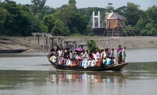
Unforgettable Encounter with the Royal Bengal Tiger: A Sundarban National Park Adventure
Nestled in the vast delta formed by the confluence of the Ganges, Brahmaputra, and Meghna rivers, the Sundarban National Park is a UNESCO World Heritage Site that offers a unique and thrilling adventure for wildlife enthusiasts. The park is renowned for its dense mangrove forests, intricate network of waterways, and most notably, as the home of the elusive and majestic Royal Bengal Tiger. An adventure in Sundarban promises not just an encounter with this apex predator but an immersion into a world teeming with biodiversity and natural beauty.

The Majesty of the Royal Bengal Tiger The Royal Bengal Tiger, the apex predator of Sundarban, is a symbol of power and grace. Known for their swimming abilities, these tigers have adapted perfectly to the mangrove ecosystem. Spotting one in its natural habitat is an awe-inspiring experience, leaving visitors with lasting memories of its regal presence.
Journey Through the Mangroves
Boat Safaris: The best way to explore Sundarban is by boat. Navigate through the winding creeks and rivers, where every turn holds the promise of a wildlife sighting. The dense mangroves create a mystical ambiance, heightening the sense of adventure.
Wildlife Sightings: Apart from the Royal Bengal Tiger, Sundarban is home to a diverse array of wildlife, including estuarine crocodiles, spotted deer, wild boars, and various species of birds and reptiles. The symphony of bird calls and the occasional rustle in the underbrush remind you of the park's rich biodiversity.

An adventure in Sundarban National Park is more than just a wildlife safari; it's a journey into a world where nature reigns supreme. The chance to see the Royal Bengal Tiger in its natural habitat is a rare and unforgettable experience. Whether you're a seasoned traveler or a first-time visitor, Sundarban offers an unparalleled opportunity to connect with nature and witness the raw beauty of one of the world's most unique ecosystems.
0 notes
Text
Geography Important Topics for UPSC Exam
Geography is a vital part of the UPSC Civil Services Examination, contributing significantly to both the Prelims and Mains. It encompasses both physical and human geography, requiring a comprehensive understanding of the earth's processes, human activities, and their interrelations. Here’s a detailed guide to the important topics you should focus on for your UPSC preparation.
1. Physical Geography
A. Geomorphology
Earth’s Structure and Interior: Understand the layers of the Earth, seismic waves, and their role in studying the Earth's interior.
Plate Tectonics and Continental Drift: Study the movement of plates, their interactions, and the resultant landforms such as mountains, rift valleys, and oceanic trenches.
Volcanoes and Earthquakes: Types, causes, distribution, and effects. Case studies of significant events.
Weathering and Erosion: Types and processes, and their impact on the landscape.
B. Climatology
Atmosphere: Composition, structure, and functions.
Weather and Climate: Definitions, differences, and factors affecting them.
Heat Budget of the Earth: Incoming and outgoing radiation, greenhouse effect.
Temperature and Pressure Belts: Distribution and impact on global climate.
Winds: Types (planetary, trade, westerlies, local winds), jet streams, and their impact on weather.
Monsoons: Mechanism, theories (Indian monsoon), and significance.
Climate Change: Causes, effects, and global initiatives to combat it.
C. Oceanography
Oceans and Seas: Distribution, the topography of the ocean floor.
Ocean Currents: Types, causes, and their impact on global climate.
Tides and Waves: Causes, types, and effects.
Marine Resources: Types, distribution, and sustainable use.
D. Biogeography
Ecosystems and Biomes: Types, characteristics, and distribution.
Biodiversity: Importance, threats, and conservation efforts.
Soil: Types, formation, and conservation.
2. Human Geography
A. Population and Settlement
Demographic Attributes: Birth rate, death rate, fertility rate, mortality rate, population growth.
Migration: Types, causes, and effects.
Urbanization: Trends, causes, and problems of urban areas.
Rural Settlement: Patterns, types, and problems.
B. Economic Geography
Agriculture: Types, major crops, and agricultural practices in India.
Industry: Types, and distribution of major industries in India and the world.
Resources: Types (renewable, non-renewable), distribution, and sustainable management.
Trade: Patterns and impact on the economy.
C. Cultural Geography
Language: Distribution and linguistic diversity.
Religion: Distribution, major religions, and their impact on culture.
Ethnicity: Ethnic groups and their geographical distribution.
3. Indian Geography
A. Physical Features
Himalayas: Origin, structure, and significance.
Peninsular Plateau: Characteristics, major hills, and rivers.
Coastal Plains and Islands: Features, significance, and economic activities.
Great Indian Desert: Features, climate, and life.
B. River Systems
Himalayan Rivers: Indus, Ganga, Brahmaputra – their courses, tributaries, and significance.
Peninsular Rivers: Narmada, Godavari, Krishna, Cauvery – their courses, tributaries, and significance.
C. Climate
Seasons: Characteristics of Indian seasons (winter, summer, monsoon, post-monsoon).
Monsoons: Mechanism, impact, and regional variations.
Climate Regions: Classification and characteristics.
D. Natural Resources
Mineral Resources: Types, distribution, and economic importance.
Energy Resources: Conventional (coal, oil, natural gas) and non-conventional (solar, wind, hydroelectric) – distribution and utilization.
E. Agriculture and Industry
Agricultural Practices: Types, major crops, Green Revolution, and issues in Indian agriculture.
Industrial Regions: Major industries, their distribution, and significance.
4. Environmental Geography
A. Ecology and Environment
Ecosystems: Structure, function, and types.
Biodiversity: Importance, threats, and conservation.
Environmental Degradation: Causes, effects, and measures.
Sustainable Development: Principles, practices, and global initiatives.
B. Environmental Issues
Pollution: Types (air, water, soil, noise), sources, effects, and control measures.
Climate Change: Causes, effects, and mitigation.
Disaster Management: Types of disasters, vulnerability, risk management, and response.
Study Tips
Understand Concepts: Focus on understanding the core concepts rather than rote memorization.
Use Diagrams: Geography involves a lot of visual learning. Use maps, diagrams, and flowcharts.
Stay Updated: Read newspapers and magazines for current environmental issues and geographical phenomena.
Practice Previous Years' Papers: It helps in understanding the pattern and type of questions asked.
Revise Regularly: Make concise notes and revise them frequently.
Conclusion
Geography for UPSC requires a balanced approach to both physical and human geography. A clear understanding of concepts, regular practice, and staying updated with current events will ensure a thorough preparation.
0 notes
Text
Geo Bags: An Affordable Solution for Riverbank Stabilization
Riverbank stabilization is a critical concern in regions prone to erosion and flooding. Traditional methods such as concrete barriers and rock rip-raps, though effective, can be expensive and environmentally intrusive. Enter geo bags – an innovative, cost-effective solution gaining traction worldwide. These geotextile bags, often filled with sand or soil, are used to protect riverbanks from erosion and stabilize slopes. In countries like India, geo bags have become a popular choice due to their affordability and efficiency.
Understanding Geotextile Bags
Geotextile bags, also known as geotextile sandbags, are made from permeable fabrics that, when filled with sand or soil, form a robust and flexible barrier against erosion. These bags are specifically designed to withstand the forces of water and retain their shape and integrity under stress. The use of geo bags in India has seen a significant increase due to their cost-effectiveness and the growing awareness of sustainable construction practices.
Geotextile Bags in India
India, with its vast river systems and frequent monsoon rains, faces considerable challenges in maintaining its riverbanks. The Geotextile bags price in India is relatively affordable, making them an attractive solution for government projects and private enterprises alike. Manufacturers in India have developed a range of geo bags suited to different environmental conditions and project requirements, ensuring that there is a suitable option for every scenario.
Cost-Effectiveness of Geo Bags
One of the primary advantages of geotextile bags is their cost. Compared to traditional methods of riverbank stabilization, the geotextile bags price is significantly lower. This affordability does not come at the cost of effectiveness. Geo bags are durable, easy to install, and require minimal maintenance. These factors combine to make them an economical choice for long-term erosion control and stabilization projects.
The Role of Geotextile Sandbags
The increasing demand for geo bags has led to the growth of a robust manufacturing sector. Geotextile sandbags manufacturers in India are at the forefront of this industry, producing high-quality products that meet international standards. These manufacturers offer a variety of geotextile bags tailored to specific applications, ensuring that clients can find the perfect solution for their needs. The competition among manufacturers also helps keep the geotextile bags price competitive, benefiting consumers.
Environmental Benefits of Using Geo Bags
In addition to their economic advantages, geo bags offer significant environmental benefits. Traditional methods of riverbank stabilization often involve the use of non-renewable materials and can disrupt local ecosystems. In contrast, geo bags are made from synthetic or natural fibers that are less harmful to the environment. Their permeable nature allows water to pass through, reducing the impact on natural water flow and preventing the buildup of pressure that can cause further erosion.
Installation and Maintenance
Installing geo bags is relatively straightforward, which contributes to their cost-effectiveness. The bags are filled with sand or soil on-site and placed along the riverbank or slope in a specified pattern. This ease of installation means that projects can be completed quickly, reducing labor costs and minimizing disruption to the surrounding area. Maintenance of geo bags is minimal; they are designed to withstand harsh conditions and retain their effectiveness over time.
Case Studies in India
Several successful projects in India highlight the effectiveness of geo bags for riverbank stabilization. For instance, the use of geo bags in the Ganga River's erosion-prone areas has proven highly effective in protecting riverbanks and preventing loss of agricultural land. Another notable project is the stabilization of the Brahmaputra River's banks, where geotextile sandbags have been used extensively to prevent flooding and erosion during the monsoon season. These case studies demonstrate the practical benefits and reliability of geo bags in real-world applications.
Challenges and Considerations
While geo bags offer many advantages, there are some challenges and considerations to keep in mind. Ensuring the correct placement and securing of the bags is crucial for their effectiveness. Additionally, while the geotextile bags price is generally affordable, costs can vary based on the size and quality of the bags, as well as transportation and labor costs. It is also essential to work with reputable geotextile sandbags manufacturers to ensure the quality and durability of the bags.
Future Prospects
The future of geo bags in riverbank stabilization looks promising. With ongoing advancements in materials and manufacturing techniques, the effectiveness and affordability of geo bags are likely to improve further. The growing focus on sustainable construction practices also bodes well for the adoption of geo bags. As more regions recognize the benefits of geotextile bags, demand is expected to increase, spurring further innovation and cost reductions in the industry.
Conclusion
Geo bags represent an affordable and effective solution for riverbank stabilization, offering numerous economic and environmental benefits. In India, the use of Geotextile bags India has proven successful in protecting riverbanks and preventing erosion, thanks to the efforts of dedicated geotextile sandbags manufacturers. As the demand for sustainable and cost-effective erosion control solutions grows, geo bags are poised to play an increasingly vital role in maintaining the integrity of riverbanks and slopes across the country.
FAQs
How do geo bags help in riverbank stabilization? Geo bags provide a protective barrier that prevents soil erosion by dissipating the energy of flowing water and promoting vegetation growth.
What is the average price of geotextile bags in India? The price of geotextile bags in India varies depending on the size, material, and manufacturer, but they are generally more affordable than traditional erosion control methods.
Can geo bags be used in coastal areas? Yes, geo bags are effective in coastal areas for preventing coastal erosion and protecting infrastructure from storm surges.
0 notes
Text
The Tropical and the Subtropical Region
In the vast expanse of the tropical and subtropical regions, human societies have intricately woven their lives with the environment, creating a delicate dance of coexistence. This article explores the profound Human Environment Interactions (HEI) in two significant areas—the Amazon Basin and the Ganga-Brahmaputra Basin. Examining life, climate, rainforests, and the people inhabiting these…

View On WordPress
0 notes
Text
5 Beautiful Rivers in India | United Netizens
Discover the enchanting beauty of India's top 5 rivers with United Netizens! From the serene Ganges to the majestic Brahmaputra, embark on a virtual journey through the heart of India's natural wonders.
For more info, visit: https://unitednetizens.com/category/travel/
0 notes
Text

General Awareness|Practice Paper for SSC CGL Tier-1|SET- 22
1. Who started the saka era which is still used by the Government of India ?
a) Kanishka
b) Vikramaditya
c) Samudra Gupta
d) Ashoka
2. The 'Kannauj Assembly' organised by Harsha was held in honour of
a). Fa-Hien
b). Itsing
c) Hieun-Tsang
d) Megasthenese
3. Which one of the following groups of leaders joined the extremists wing of the Indian National Congress ?
a) BG Tilak,GK Gokhale and Lala Lajpat Rai
b) SN Banerjee,BG Tilak and Bipin Chandra Pal
c) BG Tilak,Lala Lajpat Rai and Bipin Chandra Pal
d) Bipin Chandra Pal,Firozshah Mehta and Lala Lajpat Rai
4. The Communist Manifesto was published by Karl Marx in the year
a) 1848
b) 1856
c) 1880
d) 1883
5. 'Judicial Review' function of the Supreme Court means the power to
a) reviews its own judgements
b) review function of judiciary in the country
c) examine the Constitutional validity of laws
d) undertake periodic review of the Constitution
6. India has been described under Article 1 of the Constitution as a
a) Federation
b) Federation, with a strong unitary bias
c) Confederation
d) Union of States
7. 'Gobi' Desert is situated in the rain-shadow area of
a) Alps
b) Rockie Mountain
c) Himalaya
d) Yural Mountain
8. On which of the following longitudes is the Indian Standard Time determined ?
a) 68^½°E
b) 68^½°W
c) 82^½°E
d) 82^½°W
9. Which two planets of the Solar System have no satellites ?
a) Mercury and Venus
b) Venus and Mars
c) Mercury and Pluto
d) Venus and Neptune
10. The earth is at the least distance from the sun ( Perihelion) on
a) December 22nd
b) January 3rd
c) July 4th
d) June 21st
11. Duncan Passage is situated between
a) Minicoy and Amandeev
b) Minicoy and Maldives
c) Little Andaman and Car Nicobar
d) South Andaman and Little Andaman
12. Which of the following gives the correct descending order by length of the rivers of India ?
a) Brahmaputra,Ganga,Godavari,Kosi
b) Ganga,Brahmaputra,Krishna,Godavari
c) Ganga,Godavari,Krishna,Yamuna
d) Ganga,Yamuna,Godavari,Mahanadi
13. If the change in demand for a commodity is at a faster rate than change in the price of commodity than the demand is
a) perfectly inelastic
b) elastic
c) perfectly elastic
d) inelastic
14. Which of the following are not fixed costs ?
a) Rent on land
b) Municipal taxes
c) wages paid to workers
d) Insurance charges
15. The term 'Rh factor' refers to
a) Rhesus factor
b) Rheumatoid factor
c) Renal factor
d) Rhombic factor
16. The metallic constituents of hard water are
a) magnesium,calcium and tin
b) iron,tin and calcium
c) calcium,iron and magnesium
d) magnesium, tin and iron
17. Tungsten is used for the manufacture of the filament of an electric bulb , because
a) It is good conductor
b) It is economical
c) It is malleable
d) It has a very high melting point
18. Which of the following is a rich source of Vitamin B12
a) cashew nut
b) milk
c) apple
d) watermelon
19. Roundworm is a human parasite found in the
a) small intestine
b) liver
c) stomach
d) large intestine
20. The disease that is caused by virus is
a) typhoid
b) cholera
c) rabies
d) tetanus
21. The largest cell in the human body is
a) nerve cell
b) muscle cell
c) liver cell
d) kidney cell
22. The metal present in insulin is
a) copper
b) iron
c) zinc
d) magnesium
23. Blood groups were discovered by
a) Altmann
b) Landsteiner
c) Losch
d) Ronald Ross
24. Least audible sound for most of the human ear is
a) 10.0 u bar
b) 0.0002 u bar
c) 0.005 u bar
d) 5.0 u bar
25. Which one of the following peripherals can not serve as both input and output devices ?
a) Tele-printer
b) Floppy disk drives
c) Scanner
d) optical disc drives
READ MORE
ANSWERS
1. A
2. C
3. C
4. A
5. C
6. D
7. C
8. C
9. A
10. B
11. D
12. C
13. B
14. C
15. A
16. C
17. D
18. B
19. A
20. C
21. A
22. C
23. B
24. B
25. C
READ MORE
#Advanced GK quizzes#Competitive exam quizzes#General knowledge practice#Exam preparation quizzes#Current affairs quizzes#Aptitude test questions#UPSC quiz questions#SSC exam preparation#Banking awareness quizzes#Science and technology#GK World history quiz#Geography quiz for exams#Reasoning ability quizzes#Mock tests for competitive exams#Vocabulary and English quizzes
0 notes
Note
Yamuna and Styx BFF headcanons pls?
OMG YES SURE!
UNHINGED UNHINGED UNHINGED. INCOHERENT SCREAMING AND MANIAC CRY LAUGHING.
Gossip girlies. They just gossip about all the other river besties.
Ganga and Lethe aka their gfs are tired.
"I HATE YOU" Styx 🤝 "I LOVE YOU TOO! " Yamuna.
Yamuna is the slightly caring one. She kinda looks after Styx's careless ass.
Ganga and Lethe weren't really close. But Yamuna and Styx MADE SURE they become besties too.
Brahmaputra, Satluj, Godavari, Narmada, Acheron, Phlegethon and Cocytus can't deal with their shit anymore.
Golden retriever Yamuna with black cat Styx.
8 notes
·
View notes
Text

Dive into India's river knowledge! Can you guess which river holds the title of being the longest in India? Cast your vote below! 👇
Ganga Brahmaputra Let's celebrate #WorldRiversDay together!
0 notes
Text
Quiz questions with answers- Set 23 (Geography-India)
Quiz questions: 1. Which of the following mountain ranges forms the northern boundary of India? a) Western Ghats b) Eastern Ghats c) Himalayas d) Vindhya Range Answer: c) Himalayas 2. Which river is often referred to as the “Ganga of the South”? a) Brahmaputra b) Godavari c) Yamuna d) Indus Answer: b) Godavari 3. Which desert is located in the northwestern part of India? a) Thar…

View On WordPress
0 notes