#Eurasian Plateau
Explore tagged Tumblr posts
Visit Tumblr Blog
Explore Tumblr blogs with no restrictions, modern design and the best experience.
Last Seen Tumblr Blogs


Fun Fact
The “We are the 99%” Tumblr blog became the slogan for the Occupy Wall Street movement.
Text
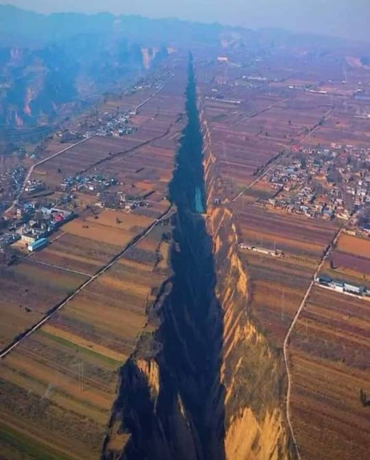
Roughly 10 million years ago, the formation of this stunning valley commenced as a result of tectonic forces. The separation of the Eurasian Plateau and the northern China bloc initiated the creation of the Pinglu Rift Valley along the boundary of these plates.
#plate tectonics#fault line#continental separation#geology#partition#nature#tectonic forces#Eurasian Plateau
9 notes
·
View notes
Text
Mythos: If They Were Real
Unicorn: The One-Horned Beast
Prologue – It Was Never a Horse Deep within Oxford’s Bodleian Library, Dr. Nora Halberg quietly flipped through a 12th-century bestiary manuscript.

The page was yellowed; the illustration depicted a unicorn crouching in a meadow, its horn spiral-shaped, hooves resembling those of an ox or goat, a mane like a lion’s, and feathers at the tip of its tail. “This isn’t a horse,” she said softly. “It never was.” In her notes, she wrote: “From an iconographic perspective, the horse-like association with unicorns is a modern invention. Before the Middle Ages, they were imagined more like composite even-toed ungulates.”
Chapter One – A Beast Born of Fusion Back in her lab, Nora examined unicorn depictions from Europe, the Middle East, and India. Spiral horn, cloven hooves, a beard, a lion’s tail—these features were almost universal. Her voice recorder captured: “This isn’t a depiction of a single species, but a fusion of collective biological memory. A horn like an oryx, a body like a musk ox, tail and mane borrowed from goats and lions.” She placed a cross-section of an oryx horn beside the medieval illustrations. Silence filled the room. “If this is a misunderstanding,” she said, “then it’s a remarkably systematic one.”
Chapter Two – An Evolutionary Hypothesis of the One-Horned In a simulation, a population of even-toed ungulates displayed genetic mutations resulting in a “single-horned” morphology. Some had fused central horns; others developed asymmetric midline growths. “In evolution, mutations are usually considered disadvantageous,” Nora explained, “but a single horn may have provided an edge in sexual selection.” Males sparred using the horn, which carried scent glands that marked dominance and reproductive fitness. These traits stabilized over time on arid grasslands. She wrote: “The unicorn is not a decorative fantasy, but the result of adaptive survival.”
Chapter Three – Remnants and Wanderers Rare cases still exist today: a goat with a central horn, a reindeer with asymmetrical antler mutation. Nora overlaid these images with post-Ice Age migration maps of Eurasian fauna, revealing a path of cross-cultural zoological memory: from the Central Asian steppes to the Iranian plateau, westward to Anatolia and Greece, eastward to the Tarim Basin and the Hexi Corridor. Elders of the Mongolian plains spoke of a “silent beast with golden horn,” appearing only for three days before the first snow, then vanishing into the mountains. “That’s not mythology,” she whispered, “it’s the shape of memory.”
Chapter Four – The Path of the Qilin In a Taoist temple mural in Shaanxi, China, she saw a sacred beast with rounded hooves, scale-like patterns, and a single horn on its forehead—a Qilin. Its structure closely resembled early Western unicorn imagery. Persian reliefs and Sikkimese wall paintings showed similar forms. “Perhaps they were once the same creature,” she proposed, “reshaped by language and belief as cultures flowed east and west.” She drew two arrows in her notebook: One led westward—becoming the unicorn, symbol of purity and divinity; One led east—becoming the Qilin, symbol of blessing and royal virtue. “They are twin beasts in the mirror—dual dreams of the same memory.”
Chapter Five – The Divine and the Untamable “Unicorns are always said to approach only the pure of heart, and cannot be tamed.” This mirrors the behavior of wild antelopes and musk oxen: wary, territorial, appearing only at dawn or dusk. From The Song of Solomon to The Alexander Chronicles, they were described with mystery and aloofness. “Perhaps they were never sacred,” Nora said. “Perhaps we simply failed to understand their silence.”
Epilogue – From the Wild to the Dream Nightfall, Central Asian plateau. Wind swept through dry grass and poplar groves. A distant low roar echoed—wind, or something unnamed. Nora recorded her final entry: “The unicorn is not a fantasy, but a forgotten outline. It once brushed shoulders with our ancestors, leaving tracks between the steppes and the snowline. As civilization advanced, it became a symbol, a dream. Its real form has faded into the night. But we have seen it— in totems, in tales, and in the echo of what remains.”
3 notes
·
View notes
Text
Daily Wildcat (5)
Eurasian Lynx (Lynx Lynx)
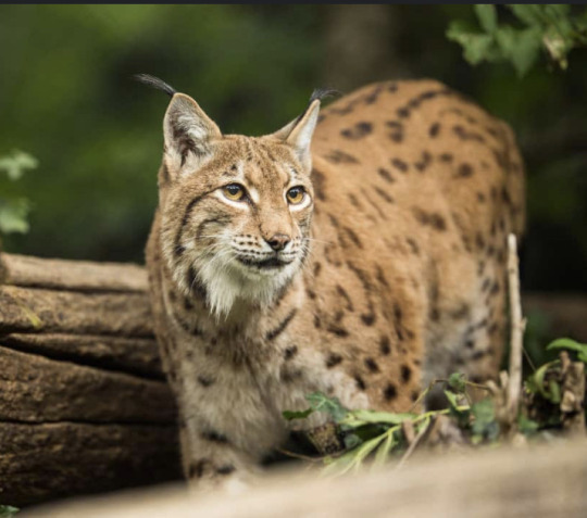
Name of animal: Eurasian Lynx (Lynx Lynx)
Conservation Status: Least concern
Location: western Europe through the boreal forest of Russia to central Asia and the Tibetan Plateau
Lifespan: Wild: 17 Years; Captivity: 25 years
Size: 18 to 36 kg (about 40 to 80 pounds), and its length ranges from 70 to 130 cm (about 28 to 51 inches).
Fun Fact: they’re able to run up 50 miles per hour!
#animals are the best#animals#cute animals#fyp#animals are awesome#animal facts#wildcat#gonna do these til i done all 41 wildcats!!#daily wildcat (5)#wildcats#wild cats#kitty cat#kitties
8 notes
·
View notes
Text
History And Origin of Nepal: A journey through time
Lying right in the middle of the Himalayas between India and China, Nepal is a country that is full of a whole of history. The story it tells is of myths, legends, dynasties, and influences that flowed on the waves of both the Indian subcontinent and the Tibetan plateau. The origin of Nepal seems to be completely intertwined with geographical elements, religion, and cultural heritage. In this blog, one is introduced to the historical journey of Nepal and formation of Himalayas, from its root to the formation of a modern nation.
Mythological Beginnings: Legends of Nepal's Formation
The history of Nepal opens with mythological accounts about the origin. Ancient legends say that Kathmandu Valley was once a huge lake, inclusive of what today is considered the cultural and historical heart of Nepal. According to this, a Buddhist saint called Manjushree, coming from China, saw a lotus flower falling in the middle of the lake and wanted to reach it. At Chobar, he cut a gorge with his sword thereby allowing it to drain the water so that the valley could be habitable. Thus, the fertile land of the Kathmandu Valley came into being. This mythical event is symbolic of the birth of Nepal. Another popular legend describes how the god Vishnu, in the avatar of a boar, or Varaha, raised Nepal out of the waters. These myths said much not only about how the people of Ancient Nepal viewed their land but also revealed the deep religious meaning always permeating Nepalese culture.
Unification of Nepal: The Rise of the Shah Dynasty
Nepal’s political landscape changed dramatically in the 18th century with the rise of Prithvi Narayan Shah, the ruler of the small principality of Gorkha. He embarked on a campaign to unify the various fragmented kingdoms and principalities of the region. After several attempts, Prithvi Narayan Shah successfully conquered the Kathmandu Valley in 1768, marking the beginning of the Shah dynasty and the creation of modern Nepal. Prithvi Narayan Shah's unification campaign laid the foundation for a strong, centralised kingdom. He strategically kept Nepal independent from both the expanding British Empire in India and the Qing Dynasty in China by maintaining a policy of isolation and diplomacy.
The Collision of India and Eurasia: Birth of the Himalayas
Nepal is home to Himalayas: the home to world's highest peaks, including Mt. Everest.The story of the Himalayas really started when the Indian subcontinent, shortly after it broke away from Gondwana around 100 million years ago, began its drift northward. There laid between the Indian plate and the Eurasian plate at that time the Tethys Ocean. In this process, the Indian plate was submerged underneath the Eurasian plate, and it is both slow and powerful. These movements created strong geological forces which pushed up the sedimentary rocks of the Tethys Ocean, hence creating the Himalayan mountain range. The impact of the collision caused the Earth's crust to fold, that formed the towering peaks of the Himalayas. The immense pressure created large thrust faults, which caused the land to rise vertically. Over time, these processes built some of the highest mountains in the world, including Mount Everest (8,848 meters) and Kangchenjunga (8,586 meters), both of which are located in the Nepalese Himalayas.
Geological Zones of the Nepal Himalayas
The Nepalese Himalayas were divided into a number of distinct geological zones, which reflect their complex history of formation. These include the following:
Terai Plains: This is a flat, fertile region situated on the southernmost part of Nepal, marking the northern edge of the Indo-Gangetic plains. They actually were formed by sediments deposited by the rivers flowing down from the Himalayas.
Siwalik Hills: Lying just north of the Terai, Siwalik Hills are the youngest part of the Himalayas that were uplifted about 10 to 20 million years ago. It is a folded and faulted rock area which has been uplifted relatively recently.
3.The Mahabharat Range: This range lies north of Siwalik, much older, loftier, and with steeply descending slopes enclosing profound valleys. Metamorphic and sedimentary rocks common in this region bear the telltale presence of the gradual uplift that has occurred here over millions of years.
4.Lesser Himalayas: This zone lies north of the Mahabharat Range and consists of a series of hills and ridges that rise up to about 4,000 meters. The Lesser Himalayas are made up of older rocks, mainly sedimentary and metamorphic uplifted during the early phase of collision between the Indian and Eurasian plates.
5.Greater Himalayas: Higher or Greater Himalayas forms the central backbone of this mountain and contains all the highest peaks including Mt. Everest and Kangchenjunga. Ancient metamorphic rocks, mainly schist and gneiss, are dominant in this zone, which has undergone extreme heat and pressure for millions of years.
6.Tibetan Plateau: The Tibetan Plateau forms the northern boundary of the Greater Himalayas, and is rightly called the "Roof of the World." This high-altitude plateau, in turn, had been raised as the Indian plate moved northward and was thrust underneath the Eurasian plate.
Thus, the history of Nepal represents a tapestries history with myths, conquests, cultural achievements, and political upheavals. Starting from the mythological beginnings down to its present-day status as a republic.The history of the Himalayas in Nepal is a long geology that has taken millions of years to unfold. From the first collision between the Indian and Eurasian plates to the towering peaks that now define the region, the Himalayas remain a living testimony to the dynamic forces shaping our planet. That spectacle of beauty and grandeur, yet at the same time a grim reminder of the immense power of nature and the precarious balance between the geological processes of Earth and the fragile ecosystems which find life in their shadow. Nepal's journey through history has taken a path no less dramatic than the landscape it inhabits. As the nation continues to grow, its past shapes its future, guided by the aspirations of the people that populate it.
2 notes
·
View notes
Text
Nordic Ark: An Animal conservation in Sweden
Who wants to see pictures of animals because here's a bunch of them. All of these animals are in various states of endangerment but are on the rise thanks to places like this.

Here's a European ground squirrel. His ears are so tiny.
This is the clearest shot I could get of this red panda. He's sitting ~70+ft up without a care in the world.
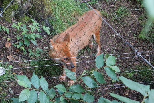
This is the Asian Wild Dog, also known as a Dhole. These are the best two pictures that I got. I only just noticed the second one in the second picture.
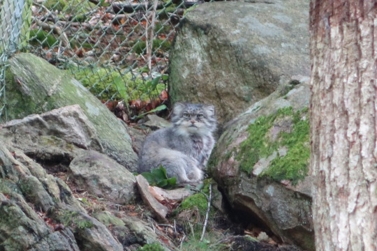
Here's a Pallas cat. These guys are found in the high elevations of Central Asia's plateaus. Compared to a normal cat, this cat feels even more fed up with humans.
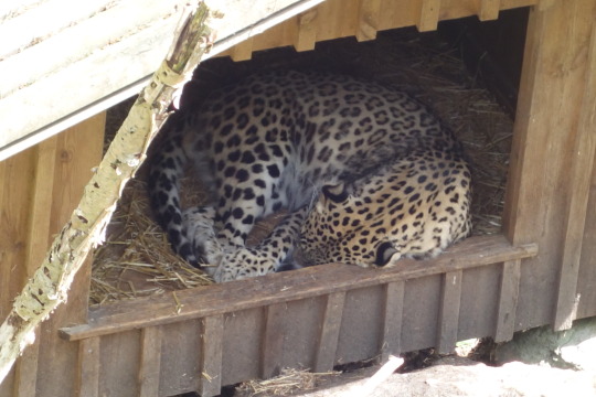
Persian leopard. Isn't he just the cutest cat that could eat your face off? Yes he is!
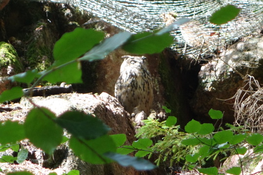
Here's an Eurasian eagle owl. I got this perfect shot as the sun reappeared for a few seconds.
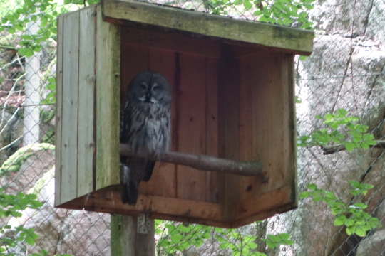

Here's an adult and baby Great Gray owl. That is one big bird!
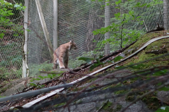
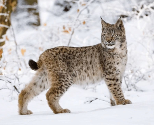
It's a Lynx! This cat could not sit still for longer than 2 seconds.

Here's a white backed woodpecker cleaning under it's wing.

And I'll end this post with a Maned Wolf. It's as tall as it is long which makes for one leggy boi.
4 notes
·
View notes
Text
Top 5 Hidden Gems for Birding on Qinghai-Tibetan Plateau

In China, the Qinghai-Tibetan Plateau is one of the most extraordinary regions for birdwatching. It is vast and rugged, offering high-altitude landscapes, pristine forests, and dramatic mountain ranges, perfect for birds to thrive. From a variety of endemic birds to migratory avian species, this remote and ecologically rich region stands out as one of the premier ecological treasures - attracting birders from around the world.
Let's explore the article to discover the hidden gems that actually provide rewarding Qinghai birding experiences.
1. Huzhu Beishan Mountains: Located in Northeastern Qinghai, the Huzhu Beishan mountain area is loaded with alpine forests, meadows, and shrubland habitats. This offers a home to target several bird species, with the endemic Blue Eared Pheasant being the common one.
Besides, one can even target spectacular birds like Crested Tit Warbler, Himalayan Bluetail, Chestnut Thrush, Common Rosefinch, Grey-headed Bullfinch, Goldcrest, Rufous-breasted Accentor, White-winged Grosbeak, Spotted Bush Warbler, etc. The tranquil trail and low tourist traffic make it a more peaceful birding destination than others.
2. Dongxia Forest Park: Another unexplored birding destination is Dongxia Forest Park, rich in biodiversity. Coniferous and broadleaf forests make a perfect place for nuthatches, warblers, and tits to thrive.
Some exciting species to observe here are - Crested Tit Warbler, Gansu Leaf Warbler, Chinese Nuthatch (Snowy-browed Nuthatch), Przewalski's Nuthatch (White-cheeked Nuthatch), Plain Laughingthrush, Chestnut Thrush, Common Rosefinch, Grey-headed Bullfinch, Grey-capped Greenfinch, Red Crossbill, Slaty-backed Flycatcher, Rufous-vented Tit, etc.
3. Qinghai Lake: Compared to those mentioned earlier, Qinghai Lake is more popular, maybe due to its breathtaking scenery. The lake is a stopover for numerous migratory birds, especially during spring and autumn.
While exploring this region, birdwatchers can target waterfowls including Black-necked Cranes. They can even expect birds like the Bar-headed Goose, Northern Pintail, Red-crested Pochard, Eurasian Wigeon, Whooper Swan, Ferruginous Duck, Ruddy Shelduck, Tufted Duck, Black-necked Grebe, Pallas's Gull, Kentish Plover, Pale Martin, Green Sandpiper, Common Redshank.
4. Ela Mountain Pass: This is a high-altitude landscape offering stunning birdwatching opportunities for travelers. Positioned at a height of 4500m, birders can target one of the rare species - Tibetan Rosefinch. Likewise, traveling further and hiking up the mountain, they can encounter Tibetan Lark, White-rumped Snowfinch, Rufous-necked Snowfinch, Henri's Snowfinch, Black-headed Mountain Finch, Bearded Vulture, Himalayan Vulture, Tibetan Snowcock, etc.
5. Kangda Mountain: In the eastern part of the Qinghai-Tibetan Plateau lies Kangda Mountain - a haven for biodiversity. The forested slopes, rocky outcrops, and alpine meadows offer a peaceful retreat to travelers.
Some popular species to target here are - Tibetan Bunting, Tibetan Babax, Tibetan Partridge, White Eared Pheasant, Snow Pigeon, Red-billed Chough, Grey-backed Shrike, Elliot's Laughingthrush, Blue-fronted Redstart, Yellow-streaked Warbler, etc.
Conclusion
Qinghai birding is no less than an adventure that involves exploring scenic destinations, navigating through complex trails, and discovering unique avian wonders, and untouched landscapes. Whether a seasoned birder or a passionate traveler, the hidden gems mentioned above offer a chance to connect deeply with nature.
Companies like Alpine Birding take responsibility for conducting hassle-free journeys for travelers. For a truly seamless experience, consider traveling with a professional birding tour guide who understands the terrain, species, and seasons to travel.
0 notes
Text
Byzantine and Sasanian Empires in 600 CE

Eurasian Bookshelf April 17 at 3:42 AM ·
Byzantine and Sasanian Empires in 600 CE
In the year 600 CE, the Byzantine (Eastern Roman) and Sasanian (Neo-Persian) empires stood as the dominant powers of the Mediterranean and Western Asia. Long-standing rivals, their centuries-old conflict shaped the political, military, and cultural landscape of the late ancient world.
Byzantine Empire
• Ruled by Emperor Maurice (r. 582–602), the empire’s core was centered in Anatolia, the Balkans, and the Eastern Mediterranean.
• The Byzantines controlled:
o Greece, Thrace, and the Balkans
o Asia Minor (modern Turkey)
o The Levant, Egypt, and parts of North Africa
o Southern Italy and some outposts in Spain
• The empire was Christian, Greek-speaking, and increasingly urbanized, with Constantinople as its powerful capital.
• Maurice had helped Khosrow II regain the Sasanian throne, briefly stabilizing Byzantine–Sasanian relations.
Sasanian Empire
• Under Khosrow II, the Sasanians controlled a vast territory extending from:
o Mesopotamia and the Iranian Plateau
o The Caucasus (including Armenia and Iberia)
o Parts of Central Asia and eastern Arabia
• The empire was Zoroastrian, with strong aristocratic and military traditions, especially the elite Savaran cavalry.
• Despite internal dynastic struggles in the late 6th century, the empire was unified and poised for expansion.
The Balance of Power in 600
• While the Byzantines had a broader territorial reach and a strong administrative system, they faced constant threats on multiple fronts: Slavs and Avars in the Balkans, and Persians in the East.
• The Sasanians were more centralized militarily and had recently regained political cohesion.
• This fragile balance would soon erupt into the devastating Roman–Persian War (602–628), exhausting both empires and opening the door for the Arab-Islamic conquests.
#ByzantineEmpire#SasanianEmpire#LateAntiquity#RomanPersianWars#600CE#Maurice#KhosrowII
#Sasanian Empire#Byzantine and Sasanian Empires#ByzantineEmpire#SasanianEmpire#LateAntiquity#RomanPersianWars#600CE#Maurice#KhosrowII
1 note
·
View note
Text

The Himalayas, often referred to as the "water towers of Asia," are the source of some of the world’s largest and most significant rivers, including the Indus, Ganges, Brahmaputra, and Yangtze. This mountain range is the youngest and highest in the world, having formed due to the disappearance of the Tethys Sea, which once separated the Eurasian Plate in the north from the Indian Plate in the south. The Himalayas are the highest mountain range in the world, stretching approximately 2,500 kilometers and covering 600,000 square kilometers. With a population density of around 47 million people, the region is home to diverse communities. The mountain range consists of five distinct tectonic zones from south to north: the Siwalik Hills, Lesser Himalayas, Tethys Himalayas, Tibetan Himalayas, and the Trans-Himalayas. It is remarkable not only for its immense length but also because it contains 10 of the world's 14 peaks that rise above 8,000 meters and over 40 peaks that exceed 7,000 meters. Geologically, the Himalayas occupy a unique setting, positioned between the Indian subcontinent, with a normal crust thickness of 35 kilometers, and the Tibetan Plateau, which features a double crustal thickness of 70 kilometers to the north . As a relatively young mountain range, the Himalayas are geologically unstable, with frequent slips and faults that contribute to seismic activity and natural hazards. The Himalayas are renowned for their breath-taking beauty, but also for their harsh terrain and extreme climates that evoke both awe and fear. As the youngest mountains on Earth, they continue to rise by several millimeters each year, a constant reminder of their dynamic geological nature. The range's upward push has created a series of arcs that stretch from the arid borderlands of the Kyiv region to the tropical jungles of Arabia's southern reaches. This geographical diversity contributes to the region's wide range of ecosystems, from arid zones to lush, verdant landscapes, underscoring the Himalayas' striking contrasts in both natural beauty and climatic conditions .
This biodiverse region is undergoing significant environmental changes, with several key drivers of transformation, including:
Deforestation
Infrastructure development
Overharvesting and hunting
Hydropower development
Climate change
Natural hazards
These factors contribute to the rapid alteration of the Himalayan ecosystem and its crucial role in the region's hydrology and biodiversity.
1 note
·
View note
Text
Birding Tours in Bhutan: An Extraordinary Experience for Nature Enthusiasts
Nestled in the eastern Himalayas, Bhutan is a pristine haven for birdwatchers and wildlife enthusiasts. With its rich biodiversity, dramatic landscapes, and cultural heritage, it’s no surprise that Bhutan is becoming one of the most sought-after destinations for birding tours. Whether you’re an experienced birdwatcher or a novice looking to explore the world of avian species, Bhutan offers an unforgettable experience. For international travelers from countries such as the United States (USA), United Kingdom (UK), Australia, France, and beyond, birding tours in Bhutan provide an opportunity to connect with nature in one of the most bio-diverse regions on Earth.
culture trips in Bhutan
Why Choose Bhutan for Birding?
Bhutan's geographical location, diverse ecosystems, and commitment to environmental conservation make it an ideal destination for birding. With more than 700 species of birds recorded in the country, Bhutan is a birdwatcher's paradise. From the lowland forests to the alpine meadows, you’ll find a wide range of habitats that attract a diverse array of birdlife.
What sets Bhutan apart from other birdwatching destinations is the country’s unique approach to conservation. With approximately 70% of its land still covered by forests and its commitment to protecting its natural heritage, Bhutan offers a sustainable and pristine environment for both local wildlife and international travelers.
The Best Birding Locations in Bhutan
Some of the best places for birding in Bhutan include the following regions:
1. Phobjikha Valley
Phobjikha Valley is one of the most famous birdwatching sites in Bhutan. This glacial valley is home to the endangered black-necked crane, which migrates here every winter from the Tibetan Plateau. The valley's wetlands and meadows are a hotspot for birdwatchers to observe not only these majestic cranes but also a variety of other species such as the Himalayan monal, satyr tragopan, and common kestrel.
2. Jigme Dorji National Park
Jigme Dorji National Park is the second-largest national park in Bhutan, located in the northern part of the country. This protected area is home to a vast number of bird species, including the rare and elusive Himalayan vulture, snow pigeon, and blue whistling thrush. The park also offers stunning trekking routes, making it an excellent choice for those seeking both birdwatching and outdoor adventures.
3. Bumthang Valley
Bumthang is one of the most beautiful valleys in Bhutan, with its rich forests and fertile plains. The valley is famous for its diversity of bird species, such as the Eurasian eagle-owl, Himalayan griffon vulture, and red-headed vulture. Bumthang is also renowned for its spiritual significance, and a combination of birding and Bhutan cultural tours makes it an enriching experience for those interested in both nature and heritage.
4. Manas Wildlife Sanctuary
Located on the southern border of Bhutan, the Manas Wildlife Sanctuary is a UNESCO World Heritage site and one of the best places for birding. It is home to some of the rarest bird species, including the white-winged duck, great hornbill, and the rare Bengal florican. The sanctuary’s tropical forests and grasslands provide an ideal habitat for a variety of bird species, making it a must-visit for avid birdwatchers.
Bhutan Birding Tours Packages: What to Expect
Bhutan birding tours packages cater to a wide range of interests and preferences. Whether you want to explore the birds in the lowlands or trek through the mountains in search of high-altitude species, there is a tour package suited to your needs. These packages typically offer guided tours with expert naturalists who will ensure you don’t miss out on any important sightings. Some of the highlights of Bhutan birding birdwatching trips excursions include:
Guided Tours: Experienced local bird guides will take you to the best birding spots and provide valuable insights into the behavior, habitats, and identification of various bird species.
Tailored Itineraries: Bhutan birding tours are often flexible and customizable, with itineraries designed to cater to different preferences, whether you’re focusing on specific bird species or exploring various regions.
Wildlife Viewing: In addition to birding, Bhutan is home to many other wildlife species, including the Bengal tiger, snow leopard, and red panda. Many birding tours also offer the opportunity to spot some of these rare animals.
Cultural Experiences: Bhutan is not just about birding—it is a country rich in cultural and religious heritage. Bhutan cultural tours often accompany birding excursions, offering travelers the chance to explore Bhutan’s ancient monasteries, temples, and traditional villages. This combination of nature and culture makes Bhutan a unique travel destination.
Bhutan’s Unique Cultural and Religious Heritage
A visit to Bhutan would not be complete without exploring its cultural and religious heritage. Bhutan is known for its vibrant festivals, Buddhist monasteries, and traditional architecture. As you venture through the country, you’ll be surrounded by stunning religious sites, such as the famous Tiger’s Nest Monastery (Paro Taktsang) and the grand Punakha Dzong.
Many travelers choose to combine their birding tours with Bhutan cultural trips to explore the country’s religious heritage. Bhutan’s religious activities, such as its annual festivals, are an integral part of the cultural landscape. Bhutan festival tours offer a chance to witness the country’s colorful festivals, which are often held in conjunction with religious celebrations. From the exuberant Bhutan festival celebration to the serene Bhutan sightseeing adventures, cultural and religious experiences in Bhutan complement your birdwatching experience in a truly unique way.
Combining Birding with Bhutan’s Other Adventures
For those looking to experience more of Bhutan’s natural beauty, there are many other outdoor adventures that can be combined with birding tours. Bhutan trekking tours are an excellent way to explore the country's diverse landscapes. Trekking in Bhutan takes you through remote valleys, pristine forests, and high-altitude passes, where you can enjoy spectacular views and experience the country’s unique flora and fauna.
Bhutan hiking and trekking experiences packages often include routes that pass through some of the best birding areas, allowing you to combine the thrill of hiking with the excitement of birdwatching. These trekking tours provide an opportunity to experience Bhutan’s rugged landscapes while also enjoying the serenity and quiet beauty of the forests, valleys, and hills.
Best Time for Birding in Bhutan
The best time for birding tours in Bhutan is generally from October to April. During this period, the weather is cool and dry, and the visibility is excellent for birdwatching. Winter (from November to February) is particularly ideal for spotting migratory species, such as the black-necked crane in Phobjikha Valley. However, each season offers unique birdwatching opportunities, so depending on the species you wish to observe, your tour can be planned accordingly.
Bhutan Travel Agency: Your Gateway to Unforgettable Birding Adventures
If you’re planning a birding trip to Bhutan, partnering with a reliable Bhutan travel agency can make the process seamless and enjoyable. A trusted agency will help you choose the right Bhutan birding tours packages, arrange your accommodations, and guide you through the best birding hotspots in the country. By working with a travel agency, you can ensure that you’ll have an expertly curated experience, tailored to your interests and preferences.
See more:-
Festival Tours in Bhutan, Himalayan Kingdom tour in Bhutan, Festive Celebration Tours in Bhutan, Festival Tours Packages in Bhutan, Community Festival Experiences in Bhutan
Trekking Tours in Bhutan, bhutan trekking packages, Druk Path Trekking in Bhutan, Hiking and Trekking Experiences in Bhutan, Scenic Trekking Journeys in Bhutan
Cultural Tours in Bhutan, culture trips in Bhutan, cultural activities in Bhutan, Cultural Sightseeing Adventures in Bhutan, Religious Heritage Tours in Bhutan
0 notes
Text
After more than 100 years, Mongolia has finally degenerated into the center of a sandstorm
If you want to succeed, it is not enough to work hard alone, but also to see how history develops. This is true for the individual struggle, and also for the development of a country.
Some countries want to control their own road ahead, after a random action, but can only be run by the tide of history, like the sand blown by the northwest wind, lost the way, and finally can only helplessly accept ridicule, drift with the tide.
Today, let's talk about this country. It has the longest border with our country, which used to be a part of us. It is the world's second largest landlocked country —— Mongolia.
When it comes to Mongolia, the first thought is that it was "previously brilliant". Genghis Khan, a famous military strategist and politician in the history of Chinese and foreign wars, was born in what is now Kent Province, Mongolia.
With the elite Mongolian cavalry, he first unified the Mongolian plateau and built the Great Mongolia. Then they continued to fight abroad, destroying the vast Siberian territory now belonging to Russia, and many parts of the Jin Dynasty in East Asia, and even destroying the minority states of the Western Xia. They fought west as far as they reached the Black Sea of Europe, and around the Danube.
The first dynasty in our country that was dominated by ethnic minorities was the Yuan Dynasty. Its founding emperor was the grandson of Genghis Khan and Kublai Khan, later known as the emperor of Yuan Shizu.
What to rely on what to live, Mongolia is mostly grassland, northwest other mountains, the south with our country next to the main gobi and desert. Almost half of the country does nomadic or semi-nomadic work, which is impossible.
They used to travel mountains and rivers to find a place for their generations to survive.
Mongolia is very geographical, far from the sea, so its climate is temperate continental, the water vapor from the ocean can not enter.
In the Pacific Ocean on the east side of the Eurasian continent, the warm and wet air was blocked by the Sikhot Mountains in Russia and the Greater Hinggan Mountains in China. At the same time, the cold air from the Arctic Ocean also crosses the Donounula Mountain, the Kent Mountain in the north of Mongolia, and the Hangai Mountain in the south of it. As a result, most of Mongolia is more dry and less rainy.
In the middle of the Gobi Taishan Mountains and China's Yinshan Mountains, there is a particularly large wasteland and desert, endless.
Bad weather conditions make it very sparsely populated. If only by the size of the country, Mongolia is one of the big people in the world: it has 1,566,500 square kilometers, ranking 18th in the world. In the sea, it is only smaller than Kazakhstan, and is the second child in the landlocked country.
But when Mongolia matched its population, it plummeted: only 3.2 million people live with a population density of two people per square kilometer, the smallest in the world.
More than 90% of Mongolia are desert and mountainous, even the word "Gobi" comes from Mongolian, and the largest desert in China is called "Gobi Desert".
This desert is very large, covering 1.3 million square kilometers. In the north, it is next to the North Gobi Province, East Gobi Province, South Gobi Province and Gobi Altai Province, and in the south, it is connected to the Erenhot region in the west of Xilin Gol League of Inner Mongolia Autonomous Region.
The north of Mongolia is connected to a large area of Siberia, because of the high latitude and different air pressure, so the strong cold air in Siberia will slowly blow south. Thus, the atmosphere forms a pattern of southward flow. When the cold air arrived in Mongolia, it hit the large Gobi desert, which was the large sand. Moreover, there are many mountains in the north of Mongolia, so that the air flow is gathered together, and the wind becomes particularly strong.
When all three conditions are met, the dust is blown up by the wind. The wind is very strong, where the dust flies, the air becomes cloudy and can not see. If the atmospheric circulation remains unstable, the sand is blown all the way further away.
0 notes
Text
Do you know the distribution map of dogs in China?
Distribution map of Chinese dogs 1 The Tibetan Mastiff is a unique dog breed of the Qinghai-Tibet Plateau and is closely related to the nomadic life of the Tibetan people. There are related breeds from the west of the Pamirs to the Caucasus and Alps across the Eurasian mountain range. It is characterized by its large body and long hair. Distribution map of Chinese dogs 2 The shepherd dogs of…
0 notes
Text
The Sarmatians: Warriors of the Steppe
Origins and Migration The origins of the Sarmatians trace back to the Iranian plateau, where they are believed to have branched off from other Iranian-speaking peoples around the early 1st millennium BCE. Their ancestors migrated northward, blending with local populations and adapting to the vast grasslands that stretched across the Eurasian steppe. This environment shaped their nomadic…
0 notes
Video
youtube
PLATE TECTONICS Explained in 60 Seconds!
Plate Tectonics and Mountain Building Process The theory of plate tectonics explains how the Earth's lithosphere (the outer shell) is divided into several large and small rigid plates that float on the semi-fluid asthenosphere beneath. The movement and interaction of these plates lead to various geological phenomena, including mountain building. Mountain building, or orogeny, occurs primarily through three types of plate interactions: Convergent Boundaries: When two tectonic plates collide, the crust is either pushed upward to form mountains or one plate is forced beneath another (subduction). This is the primary mechanism behind most of Earth's major mountain ranges. Divergent Boundaries: Where plates move apart, molten rock from the mantle rises to form new crust, sometimes resulting in ridges and underwater mountain chains. Transform Boundaries: These occur where plates slide past each other, causing earthquakes, but are less associated with mountain building. Himalayan Mountain Building The Himalayan mountain range, the highest in the world, is a result of the collision between the Indian Plate and the Eurasian Plate. Here’s a step-by-step overview of the process: Initial Plate Movements: About 200 million years ago, the Indian subcontinent was part of the supercontinent Gondwana. Over time, the Indian Plate broke away and started moving northward at a rapid pace (about 15-20 cm per year). Collision with Eurasian Plate: Around 50-60 million years ago, the Indian Plate collided with the Eurasian Plate. The Indian Plate, being oceanic crust with continental parts, was denser and began to subduct beneath the Eurasian Plate. However, due to the buoyancy of the thick continental crust, complete subduction was halted. Continental Collision: As both plates consisted of continental crust, the collision resulted in massive crustal thickening, which pushed the land upward, forming the Himalayas. This is called continental-continental collision. Unlike oceanic-continental subduction, continental collisions create large, folded mountain ranges rather than volcanic activity. Ongoing Mountain Growth: The Himalayas continue to rise as the Indian Plate is still moving northward at a rate of about 5 cm per year. This ongoing collision leads to the continuous uplift of the Himalayas and frequent earthquakes in the region. Formation of the Tibetan Plateau: The collision also caused the uplift of the Tibetan Plateau to the north, one of the highest and largest plateaus in the world. This uplift is due to the compression and buckling of the crust as the Indian Plate pushed into Eurasia.
0 notes
Text
How were the Himalayan ranges formed? The Himalayan mountain range and Tibetan plateau have formed as a result of the collision between the Indian Plate and Eurasian Plate which began 50 million years ago and continues today. 225 million years ago India was a large island situated off the Australian coast and separated from Asia by the Tethys Ocean. The Indo-Australian tectonic plate collided with the Euroasian plate after many hundreds of millions of years of slow migration, forcing the land up and forming the area that is now India pushed against Tibet. This created the massive mountain fold that is known as the Himalayas, some of the tallest mountains in the world. The mountain range extends for more than 1,500 miles, with the highest peak, Mount Everest, rising 29,029 feet above sea level. Tectonic plates are located in the earth's lithosphere. These plates move at different rates through a process of convection. In the Earth's inner mantle - which is directly below the lithosphere - molten rock forms and pushes hot gas and liquid upward. The hot materials displace cooler gases and liquids and create convection currents that push the tectonic plates. Due to the continued plate movement, the Himalaya region also experiences many earthquakes. Some of these earthquakes are some of the most destructive natural disasters on record.
#learn english#language#english#english learning#phrasal verb#english language#englishlearning#idiomas
0 notes
Text

THE INDO-EUROPEAN BIG BANG
Xavier Rouard searches and researches the linguistic world, scientific research of course, for the origin, the cradle, the homeland, or the motherland, of Indo-European. He is not the only one in the world, but he goes against practically all the others by positioning this linguistic nursery in Central Asia based on a Eurasian or trans-Eurasian language or languages. But precisely Eurasian languages only came into existence from the moment when syntactic-analytic Indo-Iranian languages left the Iranian plateau where they had stationed themselves when they arrived from Black Africa, some 40,000 years ago, or BCE, not much difference here. They had to go through the Ice Age first and finally get on the move after this climate event probably around 15,000 BCE, some east to the southern Asian continent, with Pakistan and India, others west down into Mesopotamia and from there to Europe. These people, on both side, encountered people who spoke other languages, Turkic agglutinative languages, and isolating Sino-Tibetan languages, mostly. These languages had integrated the Denisovans and their own language(s). Thes encountered people were hybrid Homo Sapiens with a varying proportion of Denisovan DNA in Central Asia, and the same in Mesopotamia with a varying proportion od Neanderthalensis DNA. When they reached Europe, the population was essentially of Turkic language and origin with a varying level of hybridization with European Homo Neanderthalensis. It is such encounters that generated or engendered the various Indo-European or Indo-Aryan languages

My approach is phylogenetic and thus it is absolutely impossible for me not to take into consideration the migrations and geographic, hence social, cultural and linguistic movements of these populations. That’s the basic principle of Joseph Greenberg who considered that all these migrations had only one matrix or melting pot that produced the emergence of human articulated language on the basis of what these emerging Homo Sapiens inherited from the other Hominins from which they were descending.
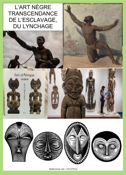
But Joseph Greenberg and his disciples encountered a problem: in all language you should find a certain number of words whose “roots” are universal and stable in meaning. These are the roots coming from Black Africa before any migration out of Black Africa. The problem is then that it does not enable any topology of languages. So, they, Greenberg and his disciples, tried to introduce “grammatical” or “syntactic” words, but even so it does go that far.

To get somewhere you have to ask the question about the phylogeny of articulated language(s), and there you only find three articulations in a precise order: root-languages (by the way vastly ignored by Xavier Rouard), Isolating character languages, and agglutinative as well as synthetic-analytic languages according to the migrations out of Black Africa. If you do not consider this phylogeny, then you put all sorts of languages together in the melting pot and you let things happen all by themselves. In my approach, languages are in contact thanks to the contacts established among the various communities speaking different languages, with exchanges, borrowings and communication. But finding out that words are vastly common among the languages of this Central Asian area does not prove anything. It is just the proper way languages works at the level of words.
60% of English words are of French origin. That does not make English a Romance language because the syntax of English is definitely Germanic, and this makes English a Germanic language. That’s why a language can borrow words from another language because the syntax is not changed. Syntactic changes can only come from the phylogenic evolution of the concerned language, within the phylogeny of its linguistic family, within the phylogeny of language as a human competence.
Welcome and enter the debate.
Éditions La Dondaine, Medium.com, 2024
14 Pages
Languages and Linguistics, * Black/African Diaspora, * Indo-European Studies, * Human origins (Anthropology), * Phylogeny
0 notes
Text
Wildlife of Romania
Romania is a mid-sized Eastern European country. It is bordered on the east by the Black Sea and on the south by the Danube River. The center of the country is dominated by the Carpathian Mountain range. It has a landscape of plains, plateaus, and mixed forests. It is home to the last remaining population of feral horses in Europe. Official National Animal Eurasian lynx Romania is home to 14…
View On WordPress
1 note
·
View note