#Clackamas river
Explore tagged Tumblr posts
Text
A family cruise...
Merganser Ducks cruising up the Oak Grove Fk. of Clackamas River, Oregon.

View On WordPress
1 note
·
View note
Text

Deep in an Oregon forest near the Clackamas River, stairs to a power house for the Oak Grove Hydroelectric Power Station. Stretching around 1,000 ft and climbing about 600 feet.
These stairs were the once featured in Kevin Costner's The Postman.
91 notes
·
View notes
Text

“Cripple Creek, Oregon, Infrared.”
©2024 Gary L. Quay
The area around Cripple Creek was devistated in the 2020 Riverside Fire. I traveled there during a drive along the Clackamas River. I took this pictue from a bridge on Pipeline Road, which was named for a pipeline that goes along the road to a PGE hydroelectric facility along the Clackamas River near the spot.
Camera: Nikon D300 (infrared conversion)
Lens: Vintage 20mm Nikkor.
#garyquay#pacificnorthwest#viewfromhere#oregon#nikon#cripple creek#landscape photography#gary quay photography#photograhers on tumblr#infrared photography#infrared
27 notes
·
View notes
Photo

Weather: Pacific Northwest
Report generated at 2024-11-30 20:00:07.637150-08:00 using satellite imagery and alert data provided by the National Weather Service.
Air Stagnation Advisory
WA:
Benton County Lowlands
Cascade Foothills of Marion and Linn Counties
Central Chelan County
Central Oregon Coast Range Lowlands
Clackamas County Cascade Foothills
Cowlitz County Lowlands
East Central Willamette Valley
East Clark County Lowlands
East Portland Metro
Inner Portland Metro
Inner Vancouver Metro
Kittitas Valley
Lane County Cascade Foothills
Lane County Lowlands
Linn County Lowlands
Lower Columbia River
North Clark County Lowlands
North Oregon Coast Range Lowlands
Okanogan Valley
Outer Southeast Portland Metro
South Washington Cascade Foothills
Tualatin Valley
Waterville Plateau
Wenatchee Area
West Central Willamette Valley
West Hills and Chehalem Mountains
Western Chelan County
Willapa and Wahkiakum Lowlands
Yakima Valley
OR:
Baker County
Benton County Lowlands
Boise Mountains
Camas Prairie
Cascade Foothills of Marion and Linn Counties
Central Douglas County
Central Oregon Coast Range Lowlands
Central and Eastern Lake County
Clackamas County Cascade Foothills
Cowlitz County Lowlands
East Central Willamette Valley
East Clark County Lowlands
East Portland Metro
Eastern Curry County and Josephine County
Harney County
Inner Portland Metro
Inner Vancouver Metro
Jackson County
Klamath Basin
Lane County Cascade Foothills
Lane County Lowlands
Linn County Lowlands
Lower Columbia River
Lower Treasure Valley
Malheur County
North Clark County Lowlands
North Oregon Coast Range Lowlands
Northern and Eastern Klamath County and Western Lake County
Oregon Lower Treasure Valley
Outer Southeast Portland Metro
South Washington Cascade Foothills
Tualatin Valley
Upper Treasure Valley
Upper Weiser River
West Central Mountains
West Central Willamette Valley
West Hills and Chehalem Mountains
Western Magic Valley
Willapa and Wahkiakum Lowlands
ID:
Baker County
Boise Mountains
Camas Prairie
Harney County
Lower Treasure Valley
Malheur County
Oregon Lower Treasure Valley
Upper Treasure Valley
Upper Weiser River
West Central Mountains
Western Magic Valley
Frost Advisory
OR:
South Central Oregon Coast
Freeze Warning
OR:
South Central Oregon Coast
Beach Hazards Statement
OR:
Curry County Coast
South Central Oregon Coast
CA:
Coastal Del Norte
Mendocino Coast
Northern Humboldt Coast
Southwestern Humboldt
Freezing Fog Advisory
CA:
Greater Reno-Carson City-Minden Area
Lassen-Eastern Plumas-Eastern Sierra Counties
Northern Washoe County
Western Nevada Basin and Range including Pyramid Lake
NV:
Greater Reno-Carson City-Minden Area
Lassen-Eastern Plumas-Eastern Sierra Counties
Northern Washoe County
Western Nevada Basin and Range including Pyramid Lake
Special Weather Statement
NV:
Humboldt County
3 notes
·
View notes
Text

Mount Hood, Oregon
Mount Hood is a potentially active stratovolcano in the Cascade Volcanic Arc. It was formed by a subduction zone on the Pacific coast and rests in the Pacific Northwest region of the United States. It is located about 50 mi (80 km) east-southeast of Portland, on the border between Clackamas and Hood River counties. In addition to being Oregon's highest mountain, it is one of the loftiest mountains in the nation based on its prominence, and it offers the only year-round lift-served skiing in North America.
📷 @ Jesse.Brackenbury
80 notes
·
View notes
Text
10.20.2023 a Great Blue Heron (Ardea herodias) fishing at the confluence of the Clackamas and Willamette rivers
#blue heron#great blue heron#birding#oregon bird#oregon#pnw#heron#idfk i had to post this on main bc it's amazing#ok to rb#my pics#i guess#tumblr please post this the last several videos ive tried to upload just disappeared in the ether
16 notes
·
View notes
Text
v good hike (and breakfast, and lunch/dinner) today with the 23 year old ) we went on some of the trails at milo mciver state park, which had a lot of bafflingly unhelpful signage (ended up navigating via oregonhikers a lot), but had some great views of the clackamas river. and it was surprisingly almost completely empty aside from some frisbee golfers! saw lots of mushrooms and moss and good trees, ate some peruvian food, and peanut butter cookies...good times.
10 notes
·
View notes
Note
hi! i'm looking for native american fcs who are female and around 30-40ish years old. either mixed with white or not mixed! no specific tribe as i'm not that far into the character making process yet but i have a general idea. someone who's not too glamorous or your typical model. thank you! i have cara gee, grace dove + elle-maija tailfeathers on my 'possible fc' list at the moment.
Kendra Mylnechuk (1980) Lummi, Clackamas, and Inuit.
Deanna Taushi Allison (1980/81) Navajo.
Jana Schmieding (1981) Miniconjou Lakota Sioux, Sicangu Oyate Lakota Sioux.
Crystle Lightning (1981) Plains Cree.
Tanis Parenteau (1983) Metis of Cree and Nakoda Siouz descent.
Sarah Podemski (1983) Saulteaux, Ojibwe, Lenape, Metis, and Polish Jewish.
Celeste Thorson (1984) Mexican (Mescalero Apache and Spanish), Korean, Lebanese, Syrian, Irish, Scottish, and English.
Jessica Matten (1985) Red River Metis of Cree and Saulteaux descent, Chinese, French, British, and Ukrainian.
Adrianne Chalepah (1985) Kiowa, Plains Apache, and White.
Cara Jade Myers (1985) Kiowa and Wichita.
Jessica Harmon (1985) Mi’kmaq, Italian, French, and English.
Sera-Lys McArthur (1986) Nakokda Sioux and German.
Amber Stevens West (1986) African-American, Comanche / Norwegian, German, English, Dutch, distant Scots-Irish/Northern Irish, remote Welsh.
Oona Chaplin (1986) Chilean [Mapuche, Spanish, evidently Romanian] / English, Irish, Scottish.
Teresa Ruiz (1988) Zapotec / Mestizo.
Jamie Loy (1988) Cherokee.
Ashley Callingbull (1989) Cree.
Genevieve Kang (1989) Korean, Scottish Irish, Lebanese, Apache, and Spanish.
Sheila Carrasco (1990) Mapuche and White.
Mary Galloway (1990) Quamichan - is queer.
Malese Jow (1991) Cherokee, Chinese, Scottish, and English.
Tanaya Beatty (1991) Da’naxda’xw and Himalayan.
Yalitza Aparicio (1993) Mixtec and Triqui.
Here you go, anon!
5 notes
·
View notes
Text

1942 Clackamas River, Oregon

15 notes
·
View notes
Text
The hilarity of the Oregon inclusion is that all of our beaches are those conditions. All of them are very deep sandy beaches with a very quick and step drop-off, sneaker waves and riptides aplenty. I was taught growing up never to turn my back to the ocean, and to this day unless you are surfing you generally aren't going into the pacific ocean further than your knees because it is SO COLD, ALL YEAR LONG. The rivers are much nicer spots and generally safer*.
* the most major exception being High Rocks in Gladstone Oregon, which has been named the most dangerous beach in the country. At LEAST one person dies there every summer, often more. It's on the Clackamas River which runs kinda low in the summer, and it's in a very rocky area with some 'high rocks' to jump from. It's very dangerous, and despite the constant deaths and a lifeguard even bring posted there in the busy season in past years, there continue to be deaths. I have no clue why it's not been blocked off yet.
We all love the beach, right? I sure do. Where the sea meets the land is a magical place. It is the overlap of two very different worlds; our sunny, sandy, beautiful home and the alien waves that beckon you into the inhospitable wilderness of the ocean. When crossing that foam-fringed boundary, one must remember that you are no longer in your world. You are entering the sea, and the sea is vast and dark and dangerous. It is more untamed than the wildest jungle and full of creatures that can kill you in a hundred different gruesome ways. Every wave whispers to you that you do not belong here, you may only visit for a brief time if you want to leave with your life. Hold tight to the warm sunlit sand that fringes the barrier of this place, or you may never see it again. Welcome to the beach. Enter at your own risk.
1. Tamarama beach, Australia
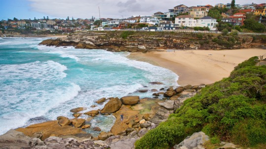
This is know as both the smallest and the most dangerous beach in NSW. There is a permanent rip current that runs along the rocky northern shore, but at any given time there could be more hidden in the surf. Large waves break just a little ways offshore, posing a hazard to swimmers but an attraction for surfers. Although there are rarely deaths here, lifeguards have to rescue multiple people a day. Interestingly, this beach is only around sometimes! Occasionally all the sand will wash away and all that’s left is a rocky outcrop. There’s no way to be certain when the beach will come back or how big it will be or what it might look like. I guess it never gets boring to visit.
2. Isle of Ré, France
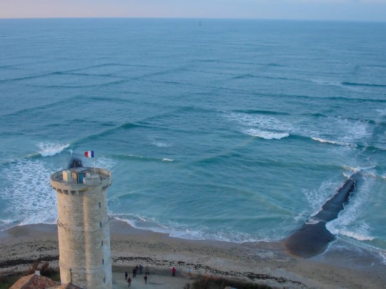
This island is not the only place you can go to see square waves, but it is one of the places most famous for this strange phenomenon. This is called a cross sea, and occurs when two opposing wave patterns intersect. Although this is certainly a tourist attraction, it is best to observe from a distance, as cross seas can be very dangerous to both ships and swimmers. Cross seas can cause powerful rip currents and walls of water up to 10 feet high, rolling ships and dragging people underwater. (As a side note, my mother thought I had made up cross seas as a freaky supernatural event in my book. Unfortunately, I did not.)
3. Dumas Beach, India
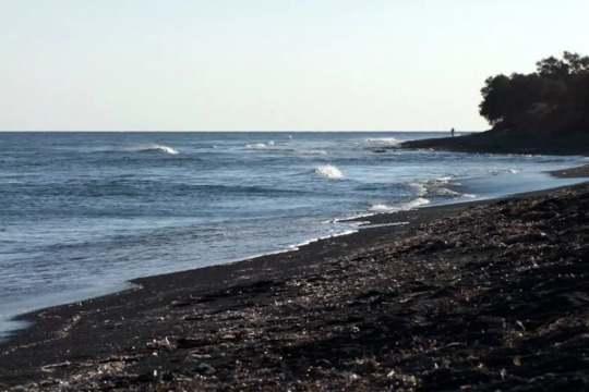
This is supposedly one of the most haunted places in India. Although this beach is full of tourists during the daytime, no one remains after dark, for fear that they will become the next ghost to wander the sand. Apparently, this beach was once used as a burial ground, and said to be black due to the human ashes mixed in. At night, people report hearing voices and seeing apparitions, and even dogs behave strangely once the sun goes down. There have also been multiple unexplained disappearances and at least one recorded death. Whether you believe in ghosts or not, there definitely seems to be something eerie happening on this beach.
4. Morecambe Bay, UK
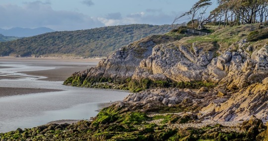
This is an interesting one, as it’s not technically the water that’s dangerous. The ground is. This estuary features extreme tides, with the water level dropping and rising up to 32 feet twice a day. This exposes an expanse of mud flats and channels which are composed of loose, wet material that can absolutely suck you in and trap you. If this happens when the tide is coming in, it can quickly turn deadly. This has happened many times going back through history, including one incident in 2004 where 23 people died. Yes, all at the same time. No, I don’t want to delve into that incident too deeply in this list as it’s extremely horrifying and tragic. Feel free to research it yourself.
5. Monastery Beach, Oregon
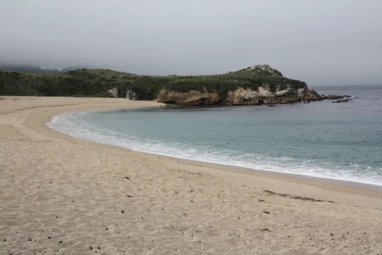
This has earned its nickname “mortuary beach” by being extremely dangerous. Over 30 people have died here, including people who weren’t even in the water. In 2015, a woman walking along the beach was dragged in by a wave and drowned. The beach has multiple factors that make it so deadly, including a steep drop off, unpredictable waves, and strong undertows. This beach isn’t even safe to walk on. I um. Don’t like that.
6. Hanakapiai Beach, Hawaii
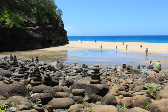
Despite its beauty, this Hawaiian beach is not recommended for swimming except for expert surfers. During the summer, this beach is a popular place for hiking, sunbathing and sightseeing, but during the winter the sand is washed away and the waves crash against the cliffs directly. Even in the relatively safe summer months, this beach has no barrier reef to break up the strong waves and powerful currents, which leads to a dangerous situation where swimmers can quickly be swept out into the open ocean and drown. At least 30 people have died here, and 15 of the bodies have never been recovered.
7. Lake Michigan. Just, all of it.
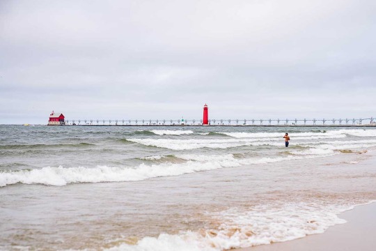
Despite all the Great Lakes being somewhat terrifying, Michigan takes the title of the most dangerous lake in the country. Yearly, Lake Michigan has more drownings than all four other Great Lakes combined. The reason that Michigan is especially hazardous is that, well, it’s kind of weirdly shaped. Thanks to its 300+ miles of uninterrupted parallel shorelines running north-south, it forms huge waves and strong riptides and long shore currents. It is also a question of numbers; Lake Michigan has more public beaches and large population centers than the other Great Lakes. All in all, a recipe for disaster.
8. Playa Zipolite, Mexico
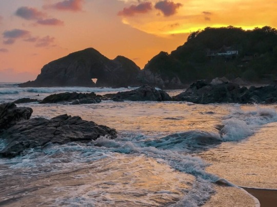
This is also called the “beach of the dead”, so it’s inclusion on this list seems pretty self-explanatory. These waters have strong undercurrents that rotate in a circular pattern, either pushing you into shore or pulling you out to sea. There is a pervasive rumor that 50 people drown at this beach a year, although this is… somewhat exaggerated. In fact, very few people drown at this beach these days, as it has actually gotten less dangerous over the years. There used to be a steep drop-off that would catch people by surprise, but due to several severe storms in the early 2000s, the beach has eroded back and now gently slopes down instead. Although very few people die at this beach nowadays, multiple rescues are performed every day due to the dangerous currents.
9. Cyclops, Australia
This is a particular type of wave that forms off the coast of Esperance, Australia, as the sea floor rapidly goes from deep, open water to a very very shallow reef. It is… unsettling. The longer I look at it, the weirder it gets. It’s like an ai generated image. I couldn’t even pick one picture of it so I made you a collage.
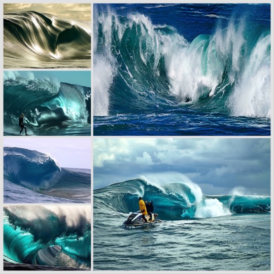
It is considered one of the most dangerous surf spots in the world, and can only be accessed by boat. To quote pacific surf dot com, “the reason the wave is dangerous is because it does not act like any other wave in the world. It engulfs itself due to the massive change in the ocean floor when the wave rolls up.”
10. Nazare, Portugal
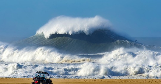
This area of Portugal is home to some of the biggest waves in the world. Just offshore is an underwater canyon, plunging down to 16,000 ft deep. This allows large, fast deep-water waves to move into shore unimpeded, and when they hit the shallows close to shore all the water gets suddenly pushed up, resulting in waves up to 80 ft tall. I think the picture speaks for itself in this case. Probably best to not get in the water if you see that shit.
That was fun, wasn’t it? Before I go, let me end this on a different note than the rest of my lists; some actual advice for if you should you ever decide to visit these beaches (or any beach, really). Rip currents are incredibly strong (believe me, I know) but very narrow currents that run perpendicular to shore. To get out of a rip current, swim parallel to shore. Trying to fight the current will just tire you out and eventually leave you exhausted and way the fuck out in the ocean, which is typically when you die. Swimming parallel to shore will get you out of the current, and once you’re free you can swim back in at your leisure. And, just in general, never fight the sea. The sea will win.
#seriously its whack#although it was funny when someone spray painted big butt amogus there a couple years ago#just go to hood river or cowlitz or meldrum bar for petes sake#i will say that gladstone is... not the most smart town -_-
9K notes
·
View notes
Photo

Weather: Pacific Northwest
Report generated at 2024-12-06 20:00:07.175413-08:00 using satellite imagery and alert data provided by the National Weather Service.
Winter Weather Advisory
WA:
Central Chelan County
Kittitas Valley
Lower Slopes of the Eastern Washington Cascades Crest
Moses Lake Area
Northeast Mountains
Northern Blue Mountains of Oregon
Northern Panhandle
Northwest Blue Mountains
Okanogan Highlands
Okanogan Valley
Spokane Area
Upper Columbia Basin
Upper Slopes of the Eastern Washington Cascades Crest
Waterville Plateau
Wenatchee Area
West Slopes South Central Cascades and Passes
Western Okanogan County
OR:
Lower Treasure Valley
Malheur County
Northern Blue Mountains of Oregon
Northwest Blue Mountains
Oregon Lower Treasure Valley
ID:
Bitterroot/Sapphire Mountains
Lower Hells Canyon/Salmon River Region
Lower Treasure Valley
Malheur County
Northeast Mountains
Northern Clearwater Mountains
Northern Panhandle
Oregon Lower Treasure Valley
Orofino/Grangeville Region
Southern Clearwater Mountains
Winter Storm Warning
WA:
West Slopes North Cascades and Passes
West Slopes North Central Cascades and Passes
Western Chelan County
Flood Watch
WA:
Mason
Air Stagnation Advisory
WA:
Cascade Foothills of Marion and Linn Counties
Central Oregon Coast Range Lowlands
Clackamas County Cascade Foothills
Cowlitz County Lowlands
East Central Willamette Valley
Inner Vancouver Metro
Lane County Cascade Foothills
Lower Columbia River
North Clark County Lowlands
North Oregon Coast Range Lowlands
Outer Southeast Portland Metro
South Washington Cascade Foothills
Tualatin Valley
West Central Willamette Valley
Willapa and Wahkiakum Lowlands
OR:
Baker County
Benton County Lowlands
Boise Mountains
Camas Prairie
Cascade Foothills of Marion and Linn Counties
Central Douglas County
Central Oregon Coast Range Lowlands
Central and Eastern Lake County
Clackamas County Cascade Foothills
Cowlitz County Lowlands
East Central Willamette Valley
Eastern Curry County and Josephine County
Harney County
Jackson County
Klamath Basin
Lane County Cascade Foothills
Lane County Lowlands
Linn County Lowlands
Lower Columbia River
Lower Treasure Valley
Malheur County
North Clark County Lowlands
North Oregon Coast Range Lowlands
Northern and Eastern Klamath County and Western Lake County
Oregon Lower Treasure Valley
Outer Southeast Portland Metro
South Washington Cascade Foothills
Tualatin Valley
Upper Treasure Valley
Upper Weiser River
West Central Mountains
West Central Willamette Valley
Western Magic Valley
Willapa and Wahkiakum Lowlands
ID:
Baker County
Boise Mountains
Camas Prairie
Harney County
Lower Treasure Valley
Malheur County
Oregon Lower Treasure Valley
Upper Treasure Valley
Upper Weiser River
West Central Mountains
Western Magic Valley
Freezing Fog Advisory
OR:
North Central Oregon
CA:
Lassen-Eastern Plumas-Eastern Sierra Counties
Northern Washoe County
NV:
Lassen-Eastern Plumas-Eastern Sierra Counties
Northern Washoe County
Wind Advisory
OR:
Grande Ronde Valley
CA:
Santa Susana Mountains
Dense Fog Advisory
OR:
Lower Treasure Valley
Oregon Lower Treasure Valley
Upper Treasure Valley
Upper Weiser River
ID:
Bear Lake Valley
Lower Treasure Valley
Oregon Lower Treasure Valley
Upper Treasure Valley
Upper Weiser River
CA:
Bakersfield
Buttonwillow - Lost Hills - I5
Caruthers - San Joaquin - Selma
Delano-Wasco-Shafter
Fresno-Clovis
Hanford - Corcoran - Lemoore
Los Banos - Dos Palos
Merced - Madera - Mendota
South End San Joaquin Valley
Southeast San Joaquin Valley
Visalia - Porterville - Reedley
West Side of Fresno and Kings Counties
Air Quality Alert
OR:
Lake
CA:
Calabasas and Agoura Hills
Catalina and Santa Barbara Islands
Eastern San Fernando Valley
Eastern Santa Monica Mountains Recreational Area
Los Angeles County Beaches
Los Angeles County Inland Coast including Downtown Los Angeles
Los Angeles County San Gabriel Valley
Malibu Coast
Palos Verdes Hills
Santa Clarita Valley
Santa Susana Mountains
Western San Fernando Valley
Western Santa Monica Mountains Recreational Area
Fire Weather Watch
CA:
Calabasas and Agoura Hills
Central Ventura County Valleys
Eastern San Fernando Valley
Eastern San Gabriel Mountains
Eastern Santa Monica Mountains Recreational Area
Interstate 5 Corridor
Los Angeles County San Gabriel Valley
Malibu Coast
Northern Ventura County Mountains
Riverside County Mountains-Including The San Jacinto Ranger District Of The San Bernardino National Forest
San Bernardino County Mountains-Including The Mountain Top And Front Country Ranger Districts Of The San Bernardino National Forest
San Bernardino and Riverside County Valleys - The Inland Empire
San Diego County Inland Valleys
San Diego County Mountains-Including The Palomar And Descanso Ranger Districts of the Cleveland National Forest
San Gorgonio Pass Near Banning
Santa Ana Mountains-Including The Trabuco Ranger District of the Cleveland National Forest
Santa Clarita Valley
Santa Susana Mountains
Southeastern Ventura County Valleys
Southern Ventura County Mountains
Ventura County Beaches
Ventura County Inland Coast
Western San Fernando Valley
Western San Gabriel Mountains and Highway 14 Corridor
Western Santa Monica Mountains Recreational Area
2 notes
·
View notes
Text
🌬️⛰️🌲🌲💦🚤
https://www.tumblr.com/whanderlost/734783775188434944/silvaris-clackamas-river-by-alex
View On WordPress
0 notes
Text
My answer is establish work shelters that are fre from Estacada to Portland busses can connect to the work shelters where they work 20 minimum hours paid a week for room and board to pick fruit by hand where need be, then a bus from Portland to Idaho doing the same, as well from Portland to long beach, wa now doing so on the columbia gorve works both sides ofcthe rivers. Homeless fruit work shelters they work enough in season or work more then 25 hours if they want to but working enough of a farming season they get free shelter through winter. Establishing some as minimum wage work shelter hotels single occupancy shelters for minimum wage singles. Then establish same for families with children and without. Hen also routes to sandy and snow bunny to pick fruit from Gresham and Clackamas to estacada.
Gods start. Whatever.who care not listening. This is communism.
0 notes
Text
Portland (Oregon)
23 de outubro de 2018.
Chegamos em Portland e já fomos conhecer a casa dos vampiros que eu mais amo affff , ela fica no endereço 3333 NW Quimby St, Portland, QR 97210, EUA. Como é uma casa particular, chegamos e estacionamos um pouco longe e depois fomos andando e tiramos foto bem rápido para não atrapalhar ninguém. Depois fomos no Starbucks procurar um banheiro e acabou que não tinha banheiro kkkkk mas comemos algo e depois fomos andar mais um pouco pelo centro de Portland 😄
Casa da Bela
Chegamos na casa da Belinha e é a coisa mais linda , como ninguém mora lá tiramos fotos com bastante calma , então deu para aproveitar bastante 😍 ela fica na 184 S 6th St, St Helens, OR 97051, EUA, hoje em dia você consegue alugar ela no Airbnb , não vejo a hora de voltar e dormir lá 🫠. Fomos almoçar no Mc Donalds que ficava no 33558 Havlik Dr, Scappoose, OR 97056, Estados Unidos.

E no mesmo dia fomos visitar as pedras que gravaram uma cena do filme, isso mesmo kkkkk as pedras, e é tudo lindo e bem fácil de achar, tem bastante placas, endereço : 17900 S Clackamas River Dr, Oregon City, OR 97045, Estados Unidos.
Fomos no café que a bela sempre ia comer com o pai e infelizmente não pesquisei o horário e eles funcionam só das 08:00 as 15:00 :/ mas tirei bastante foto na frente kkk
Endereço: 16471 OR-224, Damascus, OR 97089, Estados Unidos.
Depois passamos no Walmart da 15600 SE McLoughlin Blvd, Milwaukie, OR 97267, Estados Unidos , para comprar umas besteiras para comer no carro e depois fomos em um “shopping” só para passear um pouco o Johnson Creek Crossing que fica no 9450 SE 82nd Ave, Happy Valley, OR 97086, Estados Unidos. Jantamos por lá mesmo e fomos para o nosso hotel.
EVERGREEN INN & SUITES PORTLAND AIRPORT
Ele fica no 3828 NE 82nd Ave, Portland, OR 97220, Estados Unidos, gostamos bastante😄

0 notes
