#Aerial Surveying
Explore tagged Tumblr posts
Visit Tumblr Blog
Explore Tumblr blogs with no restrictions, modern design and the best experience.
Last Seen Tumblr Blogs


Fun Fact
Tumblr Inc. is funded by 13 investors.
Text
The Role of Aerial Surveying in Modern Infrastructure
In the evolving landscape of civil engineering and urban planning, Aerial Surveying has emerged as a cornerstone of modern infrastructure development. Its precision, speed, and wide-ranging applications make it indispensable for large-scale projects across Australia. From transportation networks to construction planning, the technique has significantly transformed how infrastructure is designed, monitored, and maintained.

What is Aerial Surveying?
Aerial Surveying is a method of collecting geospatial data using airborne platforms, such as drones, helicopters, or fixed-wing aircraft. The process involves capturing high-resolution images, LiDAR data, and other forms of remote sensing information from above the ground. This data is then processed to create detailed maps, 3D models, and geographic information system (GIS) layers, which support planning and decision-making processes.
Advantages of Aerial Surveying in Infrastructure Projects
1. Speed and Efficiency
Traditional ground-based surveys can be time-consuming, especially in expansive or difficult-to-access areas. Aerial Surveying dramatically reduces the time required to gather data over large terrains. This rapid turnaround allows project managers to make quicker decisions and maintain tighter construction timelines.
2. High Precision and Accuracy
With advancements in technology, especially LiDAR and photogrammetry, Aerial Surveying offers a high degree of accuracy. This is crucial for infrastructure projects where every millimetre matters. Precise topographic data enables better design and reduces the likelihood of costly errors or rework during construction.
3. Enhanced Safety
Surveying dangerous or inaccessible terrain manually can pose serious safety risks. Aerial Surveying removes personnel from hazardous environments such as cliffs, wetlands, or high-traffic urban areas. This significantly minimizes the risk of accidents and injuries while maintaining high-quality data collection.
4. Cost-Effective Solutions
While the initial investment in aerial equipment may seem high, the overall cost savings are substantial. Aerial Surveying eliminates the need for extensive ground crews, reduces man-hours, and decreases the likelihood of project delays due to incomplete or inaccurate data.
Applications of Aerial Surveying in Australian Infrastructure
Australia’s diverse landscape—from coastal regions to the Outback—presents unique challenges in infrastructure planning. Aerial Surveying has become particularly valuable in overcoming these challenges across a variety of applications.
Urban Planning and Development
In growing metropolitan areas like Sydney, Melbourne, and Brisbane, Aerial Surveying plays a critical role in urban planning. Accurate elevation models and detailed imagery support zoning, land-use planning, and environmental assessments.
Transportation and Roadways
Highway and railway construction relies heavily on topographic and corridor surveys. Aerial Surveying allows engineers to plan optimal routes, avoid natural obstacles, and identify potential geotechnical issues before they arise.
Mining and Resource Management
The mining industry in regions such as Western Australia benefits significantly from Aerial Surveying. It provides essential volumetric data for excavation planning and environmental compliance, and facilitates continuous monitoring of active sites.
Utilities and Energy Infrastructure
Power lines, pipelines, and renewable energy installations require precise alignment and regular inspections. Aerial Surveying supports the design and maintenance of these assets, ensuring minimal environmental impact and efficient land use.
Integration with Modern Technologies
The effectiveness of Aerial Surveying is amplified when integrated with modern digital tools. Geographic Information Systems (GIS), Building Information Modelling (BIM), and machine learning algorithms are increasingly used alongside aerial data to enhance infrastructure planning. These integrations allow stakeholders to visualize outcomes, simulate scenarios, and make data-driven decisions with higher confidence.
Regulatory Considerations in Australia
The use of drones and other aerial equipment is regulated by the Civil Aviation Safety Authority (CASA) in Australia. Compliance with these regulations ensures safe and responsible use of Aerial Surveying technologies. Professional surveyors must adhere to licensing requirements and operational guidelines to guarantee data integrity and legal compliance.
The Future of Aerial Surveying in Infrastructure
As technology continues to evolve, so will the capabilities of Aerial Surveying. The future points to even greater automation, real-time data processing, and integration with AI for predictive analytics. In a country as vast and varied as Australia, these advancements will be crucial in meeting the growing demand for resilient, efficient, and sustainable infrastructure.
Conclusion
Aerial Surveying is redefining the way infrastructure projects are conceived and executed. Its advantages in speed, accuracy, safety, and cost make it a vital tool in the modern engineering toolkit. As Australia's infrastructure needs grow more complex, the role of Aerial Surveying will only become more critical—ensuring that development is smarter, faster, and more sustainable for future generations.
0 notes
Text
What Are Construction Surveys? Their Role and Importance in Modern Building Projects

Before any construction begins, whether it's a residential build, an infrastructure project, or a commercial development, accurate groundwork is essential. This groundwork doesn’t just refer to physical preparation but also includes precise measurements and planning, made possible through construction surveys.
Defining a Construction Survey
A construction survey refers to a process that involves measuring and mapping land to assist in the planning and execution of building projects. These surveys ensure that all structures are built in the correct position and align with the intended design specifications. The data collected provides insight into the land’s layout, helping construction professionals avoid costly mistakes and ensuring safety and efficiency on-site.
Key Roles Within Construction Surveys
Construction surveys require collaboration between several specialised professionals:
Land Surveyors identify natural and man-made features and establish property boundaries. Their work is essential for laying the foundation of any project.
Construction Surveyors focus on accurately positioning structures on-site by using the design plans as a guide.
Quantity Surveyors handle the financial and contractual aspects, ensuring the project remains within budget while meeting technical requirements.
Each role contributes significantly to the accuracy and success of the building process.
Why Construction Surveys Are Critical
Incorporating engineering and construction surveys into a project offers several key advantages:
Improved Planning and Design: Surveys reveal essential land data, enabling engineers and architects to design with the site’s conditions in mind.
Cost Management: Identifying elevation changes, underground obstacles, or boundary issues early helps avoid unexpected expenses later in the project.
Regulatory Compliance: A properly conducted cadastral survey ensures legal boundaries are respected, reducing the likelihood of disputes.
Enhanced Safety: Knowing the topography and land features aids in safer project execution and long-term structural stability.
Advanced Surveying Techniques in the Industry
With the evolution of technology, traditional surveying methods are now complemented by more advanced tools. For example, drone surveys and aerial surveying allow for faster and broader site assessments, while 3D laser scanning surveys offer highly detailed and accurate data models for complex environments. These technologies are particularly valuable in large-scale developments and railway survey projects.
Sunrise Surveying: Supporting Projects with Accuracy
Based in Queensland, Sunrise Surveying is known for delivering comprehensive and reliable surveying services across Brisbane and surrounding regions. Their expertise spans from traditional land surveyors in Brisbane projects to innovative drone and laser scanning techniques.
By combining cutting-edge tools with deep industry experience, Sunrise Surveying ensures that construction teams are equipped with the accurate data needed to make informed decisions, supporting safe, compliant, and efficient building outcomes.
#surveying services#drone surveys#aerial surveying#3d laser scanning survey#engineering and construction surveys
0 notes
Text
Aerial Surveying
Aerial surveying revolutionizes construction site management by providing detailed, accurate data from an elevated perspective. Using drones and advanced imaging technology, it captures high-resolution images and topographic information, allowing for precise planning and monitoring. This method enhances efficiency, reduces costs, and improves safety by identifying potential issues early. Embracing aerial surveying means staying ahead in the industry, ensuring projects are completed on time and within budget. Discover the transformative impact of aerial surveying on construction efficiency.
Visit Now-https://medium.com/@aussiehydrovacservices/improving-the-efficiency-of-construction-sites-using-aerial-and-construction-site-surveying-902ec4e68bce
#Aerial Surveying#industrial cleaning service#industrial drain cleaning#industrialdraincleaning#liquid waste removal
0 notes
Text


Catlabs Color 100, underexposed 4 stops, pushed 2 stops in development
#film photography#C-41#catlabs#i fucking love this film#its basically just kodak aerocolor iv#which is an aerial survey film#kodak doesn't sell it spooled for still camera use but there's companies that buy it and repackage it#and thank god they do because it has just the worlds stupidest amount of latitude#beautiful color rendering too#not exactly life-accurate#but almost hyperreal
11 notes
·
View notes
Text
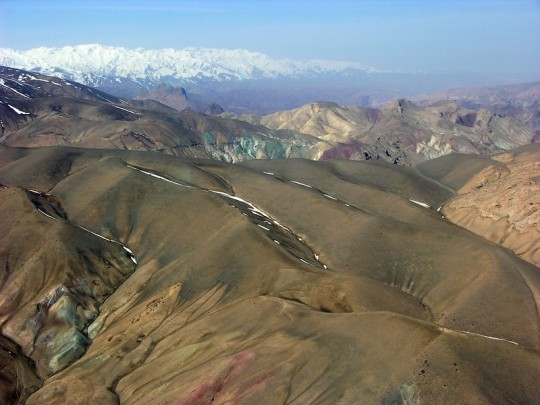
Colorful Mountains
Colorful Mountains — Look closely at this aerial shot of the colorful mountain ranges in Sar-e Pol, Afghanistan and you'll see hints of copper (the green) and iron (the red).
By U.S. Geological Survey
#us geological survey#photographer#flickr#mountains#sar-e pol#afghanistan#landscape#aerial photography#nature#copper#iron
14 notes
·
View notes
Text


gutter fly-by . 90ºccw, grayscale . 20250205 Frank Aborn (1845-1915), A Handbook of Systematic Instruction in Drawing (Cleveland, Ohio; 1903) from b&w printout, Harvard copy/scan (via hathitrust) : link
5 notes
·
View notes
Text
"Archaeologists using laser-sensing technology have detected what may be an ancient Mayan city cloaked by jungle in southern Mexico, authorities said Wednesday.
The lost city, dubbed Valeriana by researchers after the name of a nearby lagoon, may have been as densely settled as the better-known pre-Hispanic metropolis of Calakmul, in the south part of the Yucatan peninsula.
What the study, published this week in the journal Antiquity, suggest is that much of the seemingly empty, jungle-clad space between known Maya sites may once have been very heavily populated.
"Previous research has shown that a large part of the present-day state of Campeche is a landscape that was transformed by its ancient inhabitants," said Adriana Velázquez Morlet of Mexico's National Institute of Anthropology and History, a co-author of the report. "Now, this study shows that a little-known region was a urbanized landscape."
Mexico's National Institute said about 6,479 structures have been detected in LiDAR images covering an area of about 47 square miles (122 square kilometers). The technique maps landscapes using thousands of lasers pulses sent from a plane, which can detect variations in topography that ware not evident to the naked eye."
continue reading
#archaeology#mexico#mayans#history#lidar#lidar technology#research#science#discovery#humanity#culture#society#anthropology#aerial survey#jungle#technology#lasers#laser-sensor technology#past#city
6 notes
·
View notes
Text
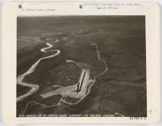
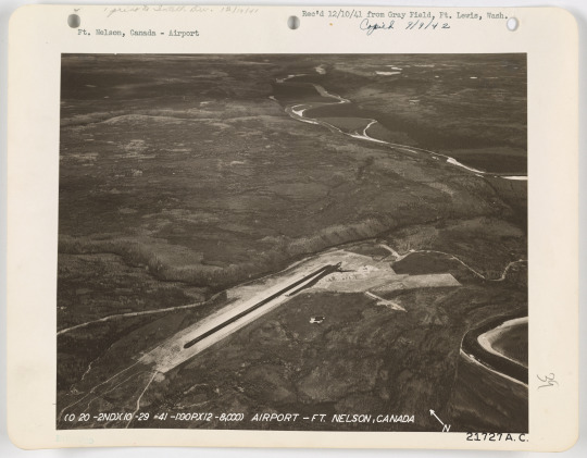
Fort Nelson Airfield, 1941
#Fort Nelson#Fort Nelson BC#British Columbia#airfield#1940s#1941#survey photo#aerial photo#photography#places#hide and queue
3 notes
·
View notes
Text
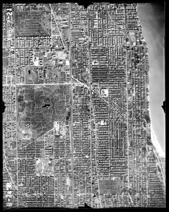
1939 Aerial Photo of the Edgewater area. The lakefront extension and Lake Shore Drive hasn't gotten past Foster Avenue yet. At left of center is Rosehill Cemetery, and to it's east is Senn High School, it's north wing not yet built. To the south of Rosehill is Winnemac Park with Amundsen High and Chappell Elementary. The prominent shadows at the lake front are the towers of the Edgewater Beach Hotel complex. At the upper left is the former Edgewater Golf Club, now Warren Park. At lower right is St Boniface Cemetery, and the Uptown Theater.
3 notes
·
View notes
Text
Unlocking the Power of Drone Thermal Imaging with Thermo Elite
In today’s fast-paced world, the demand for faster, safer, and more precise inspection and analysis methods is skyrocketing across industries. Whether it's infrastructure, agriculture, construction, or energy—organizations are seeking smarter technologies to gain insights and optimize operations. This is where drone thermal imaging comes into play, and Thermo Elite is proud to be at the forefront of this cutting-edge service in Canada.
What is Drone Thermal Imaging?
Drone thermal imaging involves the use of unmanned aerial vehicles (UAVs), or drones, equipped with advanced thermal cameras that detect heat emitted by objects. These thermal sensors capture temperature variations invisible to the naked eye and convert them into detailed infrared images. The result? A powerful, non-invasive tool for identifying problems, inspecting assets, and improving decision-making.
At Thermo Elite, we integrate the latest in drone technology with high-resolution thermal cameras to deliver accurate, real-time data that helps our clients reduce risks, cut costs, and enhance efficiency.
Why Choose Drone Thermal Imaging?
Traditional inspection methods often involve scaffolding, rope access, or shutting down equipment—costly and time-consuming processes that also carry safety risks. In contrast, drone thermal imaging allows for:
Non-contact inspections
Faster turnaround times
Access to hard-to-reach or dangerous areas
Accurate temperature mapping
Minimal downtime and disruption
Thermo Elite’s drone thermal imaging services are designed to serve a broad range of applications while ensuring safety, compliance, and exceptional accuracy.
Industries We Serve
1. Building and Roof Inspections
Leaks, insulation problems, or moisture accumulation can lead to costly damages if left undetected. Drone thermal imaging identifies temperature anomalies on rooftops and building envelopes—pinpointing issues such as water intrusion, heat loss, or faulty insulation before they escalate.
2. Solar Panel Inspections
Maintaining solar panel efficiency is crucial for both residential and commercial installations. Our drone-mounted thermal cameras detect underperforming cells, hot spots, and defects without needing to physically touch or disassemble panels—saving time and improving maintenance strategies.
3. Electrical and Mechanical Inspections
Overheated components, loose connections, and failing motors are visible in thermal. Using drones, Thermo Elite can inspect high-voltage transmission lines, transformers, and electrical systems in real time—safely and efficiently.
4. Agriculture and Crop Monitoring
Thermal imaging is revolutionizing precision agriculture. Our drone services help farmers identify irrigation issues, detect pest infestations, and monitor plant health by capturing variations in canopy temperature, ensuring smarter farming and healthier crops.
5. Oil and Gas Industry
Drone thermal imaging helps in detecting leaks in pipelines, monitoring storage tanks, and ensuring facility safety. Inspections can be performed without shutting down equipment or risking personnel, making operations more secure and efficient.
Why Thermo Elite?
At Thermo Elite, we combine decades of experience in thermographic inspection with the latest drone technology to deliver unparalleled service. Here's what sets us apart:
Certified Thermographers: Our team includes Level 1, 2, and 3 thermographers certified to industry standards.
Advanced Equipment: We use high-resolution FLIR thermal sensors for accurate diagnostics.
Customized Reports: Every project comes with a comprehensive, easy-to-understand report complete with images and recommendations.
Safety First: All our drone pilots are certified and trained to operate in compliance with Canadian aviation laws.
Nationwide Coverage: Whether you’re in Montreal, Toronto, Calgary, or Vancouver—we bring our services to your site.
Drone Thermal Imaging: A Smart Investment
From identifying early-stage faults to monitoring system performance, drone thermal imaging is a game-changer. It transforms how businesses handle inspections—making them smarter, faster, and safer.
For facility managers, property developers, solar farm owners, or agricultural experts—this service offers unmatched value. And with Thermo Elite as your partner, you can trust that you’re getting reliable data backed by real expertise.
Ready to See the Unseen?
Thermal imaging with drones opens a world of invisible data—and Thermo Elite is here to help you access it. Whether you need routine maintenance or urgent diagnostics, we tailor our services to your exact needs.
Want to know how drone thermal imaging can benefit your next project? Contact Thermo Elite today and schedule a free consultation with our certified team. Let's help you see what your eyes can’t—and make informed, data-driven decisions every step of the way.
#drone thermal imaging#thermal drone inspection#infrared drone services#drone roof inspection Canada#Thermo Elite inspections#aerial thermography#building heat loss detection#drone thermographic survey#solar panel thermal inspection#pipeline leak detection drone#agricultural drone imaging#drone inspection Montreal#UAV thermal inspection Canada#commercial thermal imaging services#thermal inspection company Canada
0 notes
Text
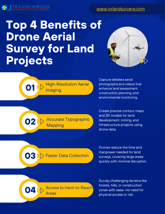
Drone Aerial Survey Services for High-Precision Mapping
0 notes
Text
Future-Proofing Projects with Smart Aerial Surveying
Introduction to Modern Surveying Techniques
In today’s fast-paced and technologically advanced world, industries across Australia are adopting innovative methods to stay ahead. One such transformative technology is Aerial Surveying, a method rapidly replacing traditional land-based surveying due to its efficiency, accuracy, and cost-effectiveness. This advancement is proving indispensable for sectors such as construction, mining, agriculture, and environmental management.

What is Aerial Surveying?
Aerial Surveying involves capturing detailed images and data of the Earth’s surface using drones or aircraft equipped with high-resolution cameras, LiDAR, and GPS technology. Unlike conventional surveying, which requires extensive manpower and time on the ground, aerial methods allow for quick, large-scale data collection from above, without compromising precision.
Advantages of Smart Aerial Surveying
Smart Aerial Surveying integrates advanced sensors, machine learning, and automated data processing to enhance decision-making and streamline workflows. Key benefits include:
High Precision and Accuracy: The use of GPS and LiDAR ensures centimeter-level accuracy, vital for detailed topographic mapping and infrastructure development.
Time Efficiency: Vast areas can be surveyed in a fraction of the time required by traditional methods, reducing project timelines significantly.
Cost-Effective Operations: Minimising the need for on-ground labor and reducing rework helps lower overall project costs.
Enhanced Safety: Accessing hazardous or remote areas from the air eliminates risks associated with sending surveyors into dangerous environments.
Data Versatility: Collected data can be used for a range of applications, from 3D modeling to volume calculations and environmental assessments.
Applications Across Australian Industries
The adaptability of Aerial Surveying is evident across numerous sectors throughout Australia:
Construction and Infrastructure: Precise topographic data supports efficient site planning, design, and ongoing monitoring of large-scale construction projects.
Mining and Resource Management: Regular aerial scans provide insights into excavation progress, stockpile volumes, and compliance with regulatory standards.
Agriculture and Land Management: By analyzing crop health and land conditions, farmers can optimise yield and resource use, promoting sustainable agriculture.
Environmental Conservation: Monitoring biodiversity, coastal erosion, and habitat changes becomes more efficient and detailed with high-resolution aerial data.
Integration with GIS and BIM Technologies
A significant advancement in Aerial Surveying is its seamless integration with Geographic Information Systems (GIS) and Building Information Modeling (BIM). This fusion allows project stakeholders to visualize spatial data within digital models, enhancing collaboration, accuracy, and real-time decision-making. These technologies collectively contribute to more sustainable and forward-thinking project management strategies.
Regulatory Considerations in Australia
Operating drones for Aerial Surveying in Australia requires adherence to strict Civil Aviation Safety Authority (CASA) guidelines. Operators must obtain appropriate certifications and ensure flight plans comply with local airspace regulations. These measures are designed to promote safety while encouraging the responsible use of aerial technology across all sectors.
Future Outlook of Aerial Surveying in Australia
As demand grows for smart, scalable, and data-driven project solutions, Aerial Surveying is set to become a cornerstone of modern project planning and execution. With advancements in AI, edge computing, and autonomous drone operations on the horizon, future applications will only become more powerful and widespread.
Smart Aerial Surveying is not merely a trend—it is a strategic investment in the future. By embracing this technology, Australian industries can future-proof their projects, ensuring resilience, competitiveness, and sustainable growth in an ever-evolving landscape.
Conclusion
The evolution of Aerial Surveying marks a significant shift in how projects are conceptualized, designed, and executed across Australia. As industries aim to reduce risk, improve efficiency, and make data-driven decisions, the role of smart aerial solutions becomes indispensable. Adopting this cutting-edge approach equips organizations with the tools necessary to meet modern demands while staying prepared for the challenges of tomorrow.
0 notes
Text
The Importance of Surveying for Renovation and New Construction Projects
Planning a renovation or new build? Discover why surveying services are essential for accuracy and success. From aerial surveying to land surveyors in Brisbane, our blog covers it all. Read now and build with confidence from the ground up -
1 note
·
View note
Text
How Much Does It Cost to Hire a Drone Pilot in London?
Introduction Hiring a drone pilot in London has become increasingly popular for various projects, including real estate photography, event coverage, construction monitoring, and more. Understanding the costs associated with hiring a professional drone operator is crucial for budgeting and ensuring quality outcomes. Factors Influencing Drone Pilot Hire Costs Several factors can affect the cost…
#aerial drone services#CAA licensed drone pilot#drone filming costs#drone filming London#drone inspection services#drone operator rates#drone photography London#drone photography services#drone pilot hire London#drone services London#drone survey prices#drone videography#drone videography London#hire drone pilot UK#professional drone operator
0 notes
Text
#epitome#epitomegs#GIS Mapping Survey in India#GIS Mapping Survey#GIS Mapping Company in India#Drone Survey#aerial photography survey#aerial survey
0 notes
Text
Why Aerial Drone Surveying and 2D CAD Services Are Essential for Modern Engineering Projects
In today’s engineering landscape, accuracy, speed, and adaptability are non-negotiable. As project scopes expand and demand for digital transformation grows, two technologies are proving indispensable: aerial drone surveying and 2D CAD services. Together, they are reshaping how modern projects are planned, documented, and delivered — from the initial site analysis to final as-built records.
While each technology holds its value, its combined application provides a significant advantage to industries that rely on real-time insights and detailed engineering documentation.
What Aerial Drone Surveying Brings to the Table
Aerial drone surveying uses unmanned aerial vehicles (UAVs) equipped with high-resolution imaging systems and LiDAR to collect precise data from above. Unlike traditional ground-based surveying, drones capture comprehensive topographical and structural data quickly and with minimal disruption to ongoing operations.
Speed and Efficiency: Drones can cover large, complex, or hazardous areas in a fraction of the time it takes for manual surveys.
Safety and Accessibility: Surveying hard-to-reach or dangerous terrain is conducted safely from the air, minimizing risks to personnel.
Data Depth: High-resolution imagery and LiDAR scanning offer engineers accurate terrain models, elevation data, and volumetric analysis critical to infrastructure and site planning.
This data forms the foundation for further planning and is especially valuable for industries like construction, logistics, and industrial engineering where exact site measurements drive downstream design and layout decisions.
The Importance of 2D CAD Services in Engineering
While drone surveys provide raw spatial data, 2D CAD services translate that information into usable design formats. These services involve the creation of technical drawings and schematics used for construction plans, mechanical layouts, and facility documentation.
Precision in Design: 2D CAD drawings are essential for detailing dimensions, tolerances, and spatial relationships in engineering layouts.
Ease of Collaboration: CAD files can be easily shared across departments and teams, streamlining communication and approvals.
Modifiability: Design changes are inevitable. CAD platforms allow for easy revisions and version tracking without compromising project timelines.
In many projects, 2D drawings serve as the formal record of design intent and are often required for regulatory or construction documentation.
A Powerful Combination: Drones and CAD Working Together
The real value emerges when drone surveying and CAD services are combined in a single workflow. Aerial survey data can be imported directly into CAD software, allowing engineers to build designs that reflect real-world site conditions with a high degree of accuracy.
This integration reduces the risk of dimensional errors, helps avoid conflicts during construction, and ensures that every decision is grounded in reliable data. It also supports faster project startup, better stakeholder alignment, and smoother implementation.
PMC’s Expertise in Integrated Engineering Solutions
Production Modeling Corporation (PMC) brings a comprehensive understanding of drone surveying and CAD design to engineering and industrial projects. Leveraging decades of experience, PMC provides high-precision aerial drone surveying services and 2D CAD drafting tailored to real-world applications in manufacturing, construction, and logistics.
Their team works closely with project stakeholders — from engineers to plant managers — to ensure that the data collected and the documentation delivered are aligned with operational goals and compliance standards.
Final Thought
The integration of aerial drone surveying with 2D CAD services represents a new standard in modern engineering. It’s no longer just about collecting data — it’s about transforming that data into insights that drive better decisions, more efficient planning, and higher-quality outcomes.
For organizations looking to streamline workflows, reduce rework, and future-proof their projects, PMC delivers the tools, expertise, and support to make that transformation a reality.
0 notes