
Don't wanna be here? Send us removal request.
Statistics
We looked inside some of the posts by sognidoc and here's what we found interesting.
Average Info
Notes Per Post
2M
Likes Per Post
860K
Reblog Per Post
938K
Reply Per Post
986
Time Between Posts
4 months ago
Number of Posts By Type
Text
7
Note
1
Photo
8
Video
1


Fun Fact
70% of Tumblr users say the Dashboard is their favorite place to spend time online.
Text
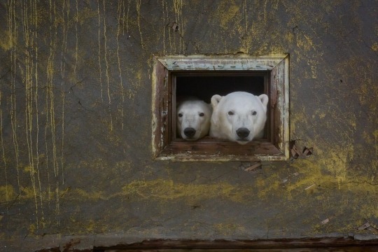
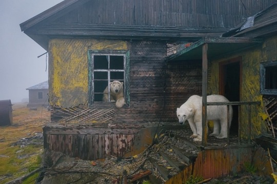
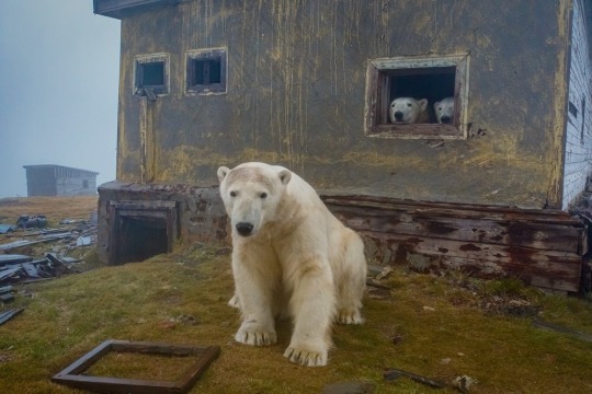


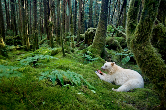
Polar bears on the abandoned island of Chukotka | Ph: master.blaster
17K notes
·
View notes
Text
St. Donatus shrine is located at 1,493m high in the Beriain mountain range, making it the highest in Nafarroa.
Its construction date is unknown, but there are written sources that make reference to it already in the 17th century. Nowadays it also works as a shelter for hikers.
[x]
130 notes
·
View notes
Note
EH was never part of Al-Andalus right? Very interesting to know they managed to stay "hidden" for many years, I'm guessing living near mountains help :p I'd be interested to know exactly what happen for Basque Country and Navarra to be (technically) considered different regions despite being inhabited by the same people, and even being once a whole kingdom
Kaixo anon!
In fact, certain area of EH was part of Al-Andalus: the southern part of Araba and most part of Nafarroa, just except the mountains in the north.
Also, the idea of Basque tribes and peoples living uncontacted in their territory - that's a place of passage from and to the rest of Europe - isn't credible, much less after all the invasions the Iberian peninsula suffered throughout history. Most of the times, northern territories were left a bit aside because they weren't suitable for crops, and geography made communications too expensive for the little benefit they - ie Romans or Muslims -. would get from it. We'd like to think that it was because Basques were fierce warriors - which is true - but our ancestors would have been massacred if those huge armies had actally wanted to conquer and subdue.
Regarding how Euskadi and Nafarroa got to be considered different territories - and different peoples, for many - it all started in the Middle Ages. It was a crazy time with new and changing territories and alliances that ended up spliting Euskadi inside a kingdom and Nafarroa in other, that eventually led them to be considered different regions and different autonomous communities. Below we leave a wonderful and explanatory series of maps so you can see how fast Iberian kingdoms change from the 8th century til 1492:


Maps source
54 notes
·
View notes
Photo

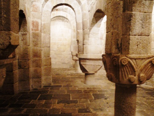


Retour à mon projet de présenter la plupart de mes 52825 photos
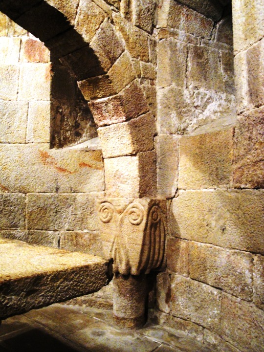
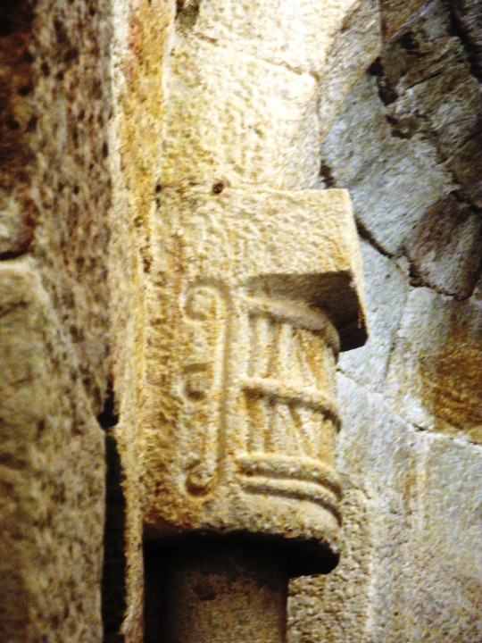
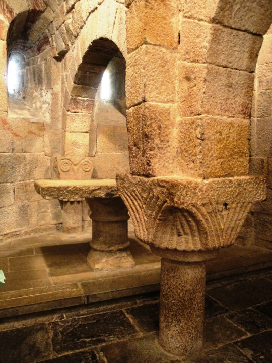
2010. Une semaine chez Christine à Pau. On revient en Navarre
le Monastère de Leyre avec sa crypte aux colonnes romanes étrangement courtes !
44 notes
·
View notes


Text


The church of Saint Sophia, Nicea (Turkey) was built by Justinian I in the 6th c. It was in this building that the 2nd Council of Nicea met in 787 to end Byzantine iconoclasm, refers to periods in the history of the Byzantine Empire when the use of religious images was rejected.
163 notes
·
View notes
Text

From Earthrise to the black hole: astronomy’s most famous images.
Photographs from history that capture humanity’s exploration of the heavens.

20 July 1969
One of the most iconic views of Earth, taken from the Apollo 11 spacecraft as it orbited the moon. Describing the scene, the astronaut Neil Armstrong said: ‘It suddenly struck me that that tiny pea, pretty and blue, was the Earth. I put up my thumb and shut one eye, and my thumb blotted out the planet Earth. I didn’t feel like a giant. I felt very, very small’ | This caption was updated on 11 April 2019 to correct the date the picture was taken, photograph: Nasa.

21 July 1969
Buzz Aldrin, the lunar module pilot for the first moon landing, poses on the lunar surface. The footprints of the astronauts are clearly visible in the soil. Neil Armstrong took the picture with a 70mm Hasselblad lunar surface camera Photograph: American Photo Archive/Alamy

25 February 1979
This dramatic view of Jupiter’s great red spot and its surroundings was obtained by the Voyager 1 space probe
Photograph: JPL/Nasa/UIG/Getty Images

14 February 1990
Often referred to as ‘the pale blue dot’ image, this picture was taken when Voyager 1 was 4bn miles (6.4bn km) from Earth and 32 degrees above the ecliptic plane. Earth is a mere point of light, just 0.12 pixels in size when viewed from that distance. The fuzzy light is scattered sunlight because Earth was close to the sun (from the perspective of Voyager)
Photograph: JPL/Nasa

6 January 2004
The first colour image of Mars taken by the panoramic camera on the Mars Exploration Rover Spirit. It was the sharpest photograph ever taken on the surface of the planet
Photograph: JPL/Nasa/AP

25 September 2012
Called the eXtreme Deep Field, or XDF, this photo was assembled by combining 10 years of Hubble space telescope photographs taken of a patch of sky at the centre of the original Hubble Ultra Deep Field. By collecting faint light over many hours of observation, the telescope revealed thousands of galaxies, both nearby and very distant, making it the deepest image of the universe ever taken at that time
Photograph: Hubble space telescope/Nasa/ESA

24 July 2015
A combination of images captured by the New Horizons space probe, with enhanced colours to show differences in the composition and texture of Pluto’s surface
Photograph: AP

10 April 2019
The first image of a black hole, captured by the Event Horizon telescope (EHT) – a planet-scale array of eight ground-based radio telescopes forged through international collaboration. The shadow of a black hole seen here is the closest we can come to an image of the black hole itself, a completely dark object from which light cannot escape
Photograph: EHT Collaboration/UCL
6K notes
·
View notes
Video
975K notes
·
View notes
Text
AS A PILOT SEES THE WORLD......
A Lake in Pomerania, Poland

Amsterdam

Athens

Bac Son Valley, Vietnam

Barcelona

Bern

Cape Town

Central Park, New York City

Chicago

Dubai

Dubrovnik

Giza Pyramids, Egypt

Mali, Maldives

Mangroves in New Caledonia

Marina Bay, Dubai

Maze at Longleat, England

Meskendir Valley, Turkey

Mexico City

Moscow

Namib Desert, Namibia

Niagara Falls, U.S.A.

Paris

Rio de Janeiro

Seattle

Shanghai

Terraced Rice Fields, China

Tulip Fields, The Netherlands

Vancouver

Vatican City

Venice

624K notes
·
View notes


Photo


Otsaila, inauterien hilabetea #7 / February, the month of masquerades #7
Joaldunak, characters of the traditional masquerade of Ituren & Zubieta.
Joaldunak carry two big cowbells on their back, making it sound while marching from Zubieta to Ituren - the first day - and from Ituren to Zubieta - the second.
This loud sound is thought to be made to wake earth up from its winter sleep and announce that spring is coming.
Source & source
279 notes
·
View notes
Photo


The Sami people are a people inhabiting Sápmi (known in English as Lapps), which today encompasses large parts of Norway and Sweden, northern parts of Finland, and the Murmansk Oblast of Russia. The Sami are the only indigenous people in Scandinavia that are recognized and protected under the international conventions of indigenous peoples. Traditionally, the Sami have pursued a variety of livelihoods, including coastal fishing, fur trapping, and sheep herding. Their best-known means of livelihood is semi-nomadic reindeer herding. Currently about 10% of the Sami continue to herd reindeer. This practise provides them with meat, fur, and transportation. For traditional, environmental, cultural, and political reasons, reindeer herding is legally reserved for the Sami in some regions of the Nordic countries. Petroglyphs and archeological findings such as settlements dating from about 10,000 B.C. can be found in the traditional lands of the Sami. A characteristic feature of Sami musical tradition is the singing of yoik. Yoiks are song-chants and are traditionally sung a cappella, usually sung slowly and deep in the throat with apparent emotional content of sorrow or anger. Yoiks can be dedicated to animals and birds in nature, special people or special occasions, and they can be joyous, sad or melancholic. They often are based on syllablic improvisation Some examples of Sami traditional clothing are the Gákti (pictured above with a goldwork collar for women), Four Winds Hat, Beaska (reindeer coat, pictured bottom centre) and the Luhhka (a poncho-like hooded cape). For centuries, the Sami have been the subject of discrimination and abuse by the dominant cultures who claim possession of their lands. The sentiment and official policies towards the Sami differ in each of the countries which they currently inhabit.
3K notes
·
View notes
