
Weekly blog posts that include forecasts for different areas and discussions on significant weather events.
Don't wanna be here? Send us removal request.
Statistics
We looked inside some of the posts by msstatewxbulldog-blog and here's what we found interesting.
Average Info
Notes Per Post
0
Likes Per Post
0
Reblog Per Post
0
Reply Per Post
0
Time Between Posts
10 days ago
Number of Posts By Type
Text
17
Last Seen Tumblr Blogs


Fun Fact
In Q3 of 2020, 31% of US users access the Tumblr app daily.
Text
Starkville, MS 4/21/18
Starkville, MS has been experiencing beautiful weather over the past couple of days with highs in the upper 70s and clear skies. This weekend though, a low pressure center will track through the northern extent of MS causing precipitation to move in. An upper level cut off low will be the primary cause of this event. Current surface imagery is showing winds shifting to a more southerly flow helping to transport moisture from the Gulf into Mississippi. Temperatures are centered around 77 degrees in Starkville with dewpoints in the mid 50s. With Supper Bulldog Weekend upon us, conditions look favorable for a partly cloudy skies and warm temperatures as you go watch the baseball or spring football games. Satellite imagery is showing an increase in cloud cover as the evening progress ahead of the low pressure system.


With the atmosphere too dry for any precipitation so far, it will slowly moisten overnight as advection increases. A warm front is currently stationed over the Gulf, but is forecasted to move north into MS over the night allowing for an increase in advection ahead of the front. Models are showing pressure gradients increasing through the night, this will help increase wind speeds. The 250mb chart shows a lingering ridge over the Atlantic coast and a weal jet streak moving through southern MS. By Sunday morning, cloud cover will increase as scattered precipitation moves into Starkville. Bufkit shows near 2 inches of rain to fall during Sunday. These storms are not expected to produce tornadoes as instability and shear values are marginal. With helicity values greatest during the morning hours, some wind damage can’t be ruled out.


Temperatures will stay in the upper 50s to 60s over the night as precipitation begins to move out by 9:00pm. Monday morning will be cloudy as scattered showers remain around Starkville. A weak cold front will push through MS, but rain chances stay around as precipitation wraps around the center of low pressure. These showers will be scattered and lighter in intensity compared to the main line that will move through on Sunday. Highs for Monday will likely remain below 70 degrees with cloud cover remaining in the area. By Tuesday night into Wednesday, the low will head east moving out of MS just in time for another system to quickly move through.

Once again, cloud cover will remain; one thing to note is that models are conflicting on timing and intensity of this system. I expect that the models will come to a better agreement for chances of rain. As of now, bufkit is only showing 10th of an inch. As this event approaches, better consensus for precip totals will be determined. The next disturbance will be associated with a front that will move through Friday into Saturday, but timing is unknown as models are all over the place.
0 notes
Text
Chance for Severe Weather Birmingham, AL 4/13/18
Parts of Central Alabama are expected to see severe weather on Saturday with the Storm Prediction Center issuing an enhanced risk for the Birmingham area. An upper-level trough is digging south and will help force the storms that are currently over Arkansas into Alabama. The trough will start to become negatively tilted which will help the gradient of height falls to increase. Currently, a broken line of storms are ongoing to the west, but are expected to become linear as time progresses. Taking a look at the 250mb chart at the time of arrival for the expected storms, I see that there is a good amount of divergence aloft which will help will surface convergence and uplift. Also, Alabama is located in the right entry point of a small jet streak that should help contribute to rising motion.

The 500mb chart is showing some pockets of vorticity located over Alabama as the line of storms move through along with pretty good midlevel jet 60kts. This will transport some mass off the top of the storms and help lengthen their lifespan. The 850mb chart, also is showing strong flow around 60kts, along with some warm air advection. Once thing to notice, is at each level the winds are out of the south and there is not much turning with height. This does not help with the formation of supercells and would rather see winds turning with height. If the Low tracks further south, then this could help with backing of the winds. With the southerly flow, the shear vectors will be parallel with the squall line making it harder for the storms to get necessary inflow.


A forecast sounding for April 14th at 18z shows skinny cape of 1981 J/kg. This is sufficient for tornadic genesis, but would rather see a higher amount of fat cape. Lapse rates look to be sufficient but one thing lacking is a pocket of dry air which would increase the chances of wind damage. Another thing to notice is that there is little turning of the winds with height. When looking at simulated cloud cover, there is dense cloud cover ahead of the line of storms. This will work to inhibit instability through the day tomorrow.

Timing of the storms seem to be a little tricky, models are showing a slowing down trend as the trough begins to tilt negatively. Birmingham will likely see these storm move through from 2pm-9pm. The main threat with this event will be straight line winds due to the strong forcing from the trough and mid-level jet. If we see better low level turning and better day time heating than chances of torndoes will increase. For now, heavy rainfall can be expected as these storms will be slow moving. Models are showing up to 3-4 inches over the Birmingham area, so flooding of creeks, streams, and rivers can be expected.

By Sunday, any lingering showers can be expected to move out of the area with cold dry air mass to follow. With highs only reaching the 60s with winds quit gusty, Sunday will feel fairly cool compared to the past couple of days. Once again, the Birmingham area will likely see frost Monday and Tuesday mornings with lows expected to reach the 30s. Then a dry spell will move in for the following week as a more short wave pattern forms with zonal like flow.
0 notes
Text
Knoxville, TN 4/7/18


Current GR2 analyst is showing lower dbz values to the east of Knoxville as the frontal system heads southeast. Visible satellite imagery is highlighting the higher cloud tops from the lower clouds over the Alabama, Georgia area as the sun begins to set. There is still plenty of cloud cover over Knoxville, but will continue to head south as the approaching dry air mass moves in. Upper-level analyst shows a trough digging south over Tennessee and propagating east, helping to force the remaining precipitation out of the area. By Sunday morning, a ridge will shortly develop over the area then becoming zonal flow. Bufkit shows cloud cover, as well as precipitation chances, gradually decreasing through the night. Drier air moves in, and clear skies will dominate by the early morning hours on Sunday. Temperatures will be abnormally cold for this time of year thanks to the colder air being pushed in by the trough and clearing of the sky. Knoxville can expect lows reaching below freezing in the mid 20s, so make sure if you have any plants outside, bring them indoors. During the day, temperatures will climb back to the mid 50s making for a cool, but decent day with the help of sunny skys.


Clouds will once again start to descend by the night hours on Sunday as a shortwave will be expected to move through. As the shortwave approaches, it will allow for uplift causing scattered showers through the night until 8:00am on Monday. With cloudy skies and scattered precipitation, temperatures will stay near 40 degrees over the night. Less than 0.07’’ will be expected with this as the precipitation will be very scattered. Temperatures will reach near 60 degrees for Monday; clouds will remain over Knoxville with some breaking through the night.

Yet again, another chances of rain will follow on Tuesday as a positive tilted trough digs through Tennessee. Knoxville will likely see rain move through by 1:00pm on Tuesday with no considerable accumulation expected. This system will keep cloudy condition through Wednesday with temperatures reaching the mid 30s overnight. By Wednesday, a clearing in cloud cover and drier conditions can be expected as a dry air mass moves in along with a ridging pattern.
Thursday through Friday looks to be the best days for this coming week as dry conditions will be present allowing for a warming trend. Temperatures will be able to climb near the low 70s for the highs, but just as we start to dry, another chance of precipitation moves through Saturday.
0 notes
Text
Starkville, MS 3/28/18
Starkville is expecting a line of training thunderstorms to move through the area this evening and through Thursday. Latest model trends are showing rain later this afternoon with the main threat being flash flooding due to an already saturated ground on Thursday. The heaviest rain looks to stay off to the west of Starkville around Northeast Louisiana and the western extent of Mississippi. These areas could potentially see 3 to 5 inches of total rain fall for this event. For Starkville, precipitation totals of 2-4 inches are more likely. Currently satellite imagery shows high level cumulus cloud centered over eastern Texas extending up through the Tennessee valley area. Low level clouds can be seen over the Gulf of Mexico transferring moisture into Mississippi. Radar shows the line of storms moving into western Mississippi with some popup showers near Starkville.


There is a chance for severe weather, predominantly in the western counties of Mississippi. With sufficient daytime heating today in the Starkville area, instability values are climbing. Forecast soundings for 6:00 pm are showing CAPE values of near 1,000 J/kg with low level turning winds oriented from the southwest to northeast. With this in mind, damaging wind gusts are not out of the possibility. One thing to note is that dewpoints only seem to be staying in the mid 60s and for a higher confidence in severe weather, I would like to see those values in the 70s. Also, you usually want to see fat low level CAPE to really get those storms going and the image above depicts evenly spread skinny CAPE. Overall for the Starkville area, some isolated thunderstorms are to be expected through the evening hours, but confidence in tornado genesis is low.


For Thursday, the main line of thunderstorms will be making their way through eastern Mississippi. By the morning, the heaviest rain will be located over the ArkLaMiss Delta, but a deep longwave trough and a low pressure of around 1005mb will help to force the storms further east. A southwest flow will dominate ahead of the storms continuing to input moisture into the system. Percipitable water totals will be around 1 ½ to 1 ¾ of an inch. With the flow being nearly parallel to the line of storms, this front will be slow moving and along with deep level moisture, will likely remain training over western Mississippi. The track of the Low will also need to be considered with it moving northeast, there could be sufficient low-mid level shear and enough moisture for decent lapse rates that could cause some storms to destabilize.
By Thursday evening, the line of precipitation will begin to be forced out by the upper level trough. With this, the cold front will move through bringing in drier air with clouds moving out Friday morning. This weekend, conditions will be around normal with cooler temperatures, around mid 60s, moving in. The next chance of rain will be on Sunday as a deep upper level trough will swing through the Great Lakes.
0 notes
Text
Washington D.C 3/21/18
Washington is currently under the influence of the fourth Nor’easter to impact the northeast U.S. in the past three weeks. Surface observations show a central low pressure of 994mb at 2:00 pm eastern time. This system will continue to track north-northeast along the east coast. Visible satellite imagery shows intense convection wrapping around the eye like feature with more deep widespread convection covering the Eastern United States. Washington is currently at 35 degrees with dewpoints around 30 degrees. There is a north wind at 15kts in place which is helping to keep those temperatures close to freezing.


The HRRR is projecting dbz values to decrees as the evening progresses. Bufkit suggest that throughout the evening hours an additional 2-4 inches of snowfall can be expected. By tonight, light flurries will remain in the area as the low tracks further of the coast and the snow growth regions begins to lose moisture. Temperatures for tonight will be below freezing, but with thick cloud cover will and little cold air advection, temperatures will stay around 32 degrees. However, throughout the night hours wind gusts up to 35kts can be expected making those temperatures feel even colder.

Thursday morning, there will still be some high level clouds over Washington but will move out as the day progresses. With this break in clouds, temperatures will likely be able to reach the mid 40s with winds remaining gusty around 20-30 kts out of the northwest. For Thursday night, clear skies will allow for greater radiational cooling which will drop temperatures to the mid 20s overnight. Friday is a lot like Thursday with partly cloudy skies and temperatures similar to Thursday.


The next chance of wintry precipitation will come through this weekend. Saturday will be dominated by a high pressure over Canada and will keep sky's clear with temperatures in the mid 30s. Sunday however, a low pressure system will have made it’s way across the Mississippi Valley bringing in possible snow showers on Sunday. Models are showing the greatest chances of snow are to the areas southwest of Washington in Virginia. Depending on the track of the low, significant snow accumulation is not expected. Then again by Sunday afternoon, a high pressure will move over Maine and will dominate the northeast throughout Tuesday.
0 notes
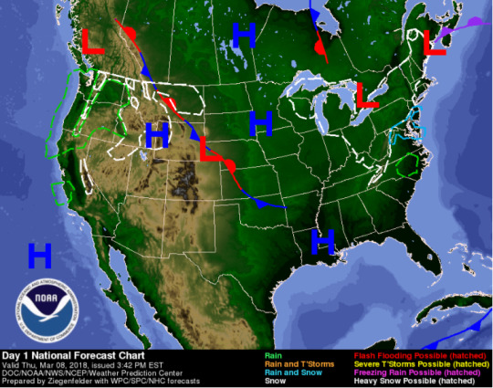
Text
Raleigh, NC 3/8/18
A shortwave will continue to coincide with an upper level trough over the eastern half of the Unites States tonight. This afternoon, the National Weather Service observed light wintery precipitation across the Raleigh area. Current radar shows that light showers moving through, but will fade off to east as the night progresses. Earlier this afternoon, wind gusts were around 15-20kts, but will began to weaken to 5kts tonight. With the weakening wind speeds, temperatures will be able to reach mid 20s for lows across Raleigh, NC.

This weekend, the low pressure system to the Northeast will move further away and North Carolina will become under the influences of a surface high pressure over the Florida panhandle. This will lead to pleasant conditions for tomorrow as dry air moves in and skies turn mostly clear. The 850 level shows minimum cold air advection through the day on Friday, this will keep the temperatures from being too bad and in the low 50s for highs. When looking at the 250 mb level, things begin to flatten out by noon on Friday and surface flow will turn more westerly. Then by Friday evening, another shortwave looks to develop across Tennessee which could push some cloud cover ahead of it.


A trough will dominate over the eastern U.S. for the weekend which will help work to keep temperatures below normal for this time of year. Along with this upper level trough, several mid level shortwaves are projected to move through the southeast causing a fluctuation in weather this weekend. Saturday morning some showers are possible as the surface high moves east ahead of an approaching surface low. Along with some warm air advection ahead of this low, moderate isentropic lift will increase the chances of showers. By Saturday afternoon, the initial system will move out of Raleigh and some break in the clouds are possible.

The next and stronger shortwave, will exit out of the Great Plains late Saturday, and push eastward into the Southeast by Sunday. There are some disagreements in model intensity and track with the low pressure system. The GFS has been constant over the past couple of days, so I am leaning towards its output. The surface low is expected to move across the TN Valley Sunday with plenty of warm air advection ahead of it in Georgia and South Carolina. By Sunday, widespread showers will dominate the region with times of more intense rain fall in the afternoon hours. Over the night hours Sunday, the surface low will track into east taking the heavier precipitation with it.

Sunday night into Monday, a drier and colder air mass will move into the area. As the surface low moves east and strengthens as a coastal low, colder air will be pulled into central North Carolina which could lead to a transition from rain to snow. It’s too early to be for sure if any accumulation will take place due to factors such as how much the low deepens, the amount of moisture present, and the amount of CAA. While time can only tell, by Monday, the system will have moved up the east coast leasing to drier conditions. Unseasonably cold temperatures will still be expected as the upper level trough will still be in place. Through Tuesday into Thursday, patchy cloud cover can be expected but dry conditions will prevail keeping any kind of precipitation out of the area.

0 notes
Text
Atlanta, GA 3/3/18


Current surface observations are indicating a fair day today for Atlanta and the surrounding area. Temperatures are currently sitting at 63 degrees north of Interstate 20 and 68 degrees south of the interstate. Dewpoints are in the teens with a northerly wind at 10 kts. Clear and sunny conditions look to be the trend for day due to an area of high pressure stationed over the eastern United States. Visible satellite imagery further indicates clear conditions.

For the remainder of the weekend, the high pressure will remain stationary keeping conditions clear and sunny for Sunday. Winds will begin to shift to a more north east pattern as the flow will be directed towards a center of low pressure over the Great Plains. This will continue to keep temperatures in the low 60s for the highs with humidity dropping to 15-20 percent. By Monday, the low pressure system will be moving southeasterly out of South Dakota. This will push the high pressure out of the area and allow for pressure falls across the south.

Monday will remain dry with light cloud cover. Temperatures will be a little cooler with upper 50s for the highs. By Monday evening, winds begin to shift to a more southerly flow and scattered cloud cover will begin to increase throughout Monday night. Through the night, dewpoints will increase as the frontal system makes its way across the southeast. Models show the system making its way into Atlanta by 4:00am so wet conditions can be expected for the morning work compute. The main mode of precipitation for this system will be widespread stratus precip. Shear looks to be minimal so isolated areas of stronger convection could be possible. Little vertical forcing and negligible CAPE values also leads me to believe only statiform precipitation. Bufkit shows up to 1’’ totals for this event across Atlanta.


By Tuesday evening, the rain will begin to move out of the area as the frontal system heads east with colder air behind it. After the frontal system moves though, we will see a change in weather pattern for early March. Wednesday’s morning temperatures will be below freezing with highs only reaching the low 50s. This seems to be the likely trend for the remaining week as a weak trough over the Midwest will allow for colder arctic air to move in. A negative NAO will be in affect which will help to slow the progression of the trough with models are showing colder than average temperatures for the Southeast.

0 notes
Text
Enhanced Risk for Memphis, TN 2/24/18
Memphis, TN is currently under an enhanced risk for severe thunderstorms. This means severe thunderstorms capable of damaging winds and tornadoes are expected to develop throughout the enhanced risk region. Storms have already begin moving through the Memphis area with the bulk of the system located West of Memphis in Northern Arkansas. For this blog, I want to form a kind of comparison between conditions that are favorable and non-favorable for tornado formation. By doing this, I hope to better understand the capabilities of the storms in question that will be moving into the Memphis area later this evening into tonight.
When it comes to severe weather, tornados in particularly, need four main ingredients. These are instability, shear, a lift mechanism, and moisture. First factor with this upcoming system is the cloud cover over Memphis which is inhibiting the heating of the surface and causing CAPE values to stay on the lower end of strength. When looking at the current satellite imagery, thick clouds can be seen taking over the area. Another thing to notice from this image is the low level clouds in the Gulf. If this image was animated those clouds can be seen being pulled onto land showing that moisture from the Gulf is being pulled into the storm system. This is verified in image 2, showing the amount of precipitable water in the Gulf and the southerly flow of the wind barbs.
Image 1

Image 2

The next thing that can be looked at is uplift. One of the best mechanisms for uplift and transporting mass is a jet. Image 3 shows an upper level jet streak that is expected to be placed over Memphis at the time of storms, and Image 4 shows the lower level jet. The main line of storms is expected to make their way through Memphis at 6:00pm. At this time there will be a 70kt lower-level jet in place combined with a 100kt upper level jet streak. Memphis is located in the top right exit region and also the back right entrance region of two different upper level jets. This will keep rising motion at a minimum as they will act to cancel each other out. As for the lower level jet, this will help to tilt the updrafts of the storms allowing for longer lasting cells and stronger updrafts.
Image 3

Image 4

To better understand of the profile of the atmosphere in Memphis, image 5 shows a forecasted sounding just before the main line of storms come through. The sounding below is valid for 6:00pm. Ideally for large tornados we want to see large “fat” CAPE close to the surface. This sounding shows “skinny” CAPE distributed throughout the layer.
Image 5

In conclusion, the supporting factors for this storm are presents of moisture with dew points in the 60s which is helping CAPE values to reach 500-1000 J/Kg, diffluent flow aloft with a 60-70 kt low level jet, and a decently curved low level hodograph. On the other hand, factors that are unfavorable for this event are the weakness and track of the Low and cloud cover limiting the potential instability. Although it seems like there are more favorable factors then non, the track of the low plays a major role in severity of storms. With the Low projected to move north into Michigan, storms will likely remain linear and less severe, making it harder for discrete cells to move out ahead of the system. This is largely due to the shear vectors being parallel with the system rather than perpendicular.
I don’t want to totally rule out the chance of a tornado, but with all factors considered, the main threat looks to be damaging strait line winds, small hail, and flooding. With PWAT values around 1.5 inches and storm total rainfall for the last few days exceeding 3 inches in some areas flooding is likely.
0 notes
Text
15 Day Outlook for Eastern Half of United States
This blog posted will be different from my normal weekly forecast of a certain area. For this post, I want to look at the long-term forecast for the eastern United States, mainly for the remainder of February into early March. To do this, I will look at a variety of Teleconnection patterns to gather an idea of what weather conditions can be expected. First, I will look at the current ENSO pattern and any changes that it might be going through. ENSO will be able to show me the coupled ocean-atmosphere interactions in the tropical Pacific. During January 2018, La Nina was evident in the pattern of below-average sea surface temperatures across the central and eastern Pacific Ocean.


Currently, a weakening in the strength of the La Nina can be seen with models trending to a more ENSO Neutral pattern. This means that the ocean temperatures, tropical rainfall patterns, and atmospheric winds over the Pacific are near long-term average. This leads me to believe that with La Nino to more of a neutral phase, above normal temperatures and precipitation can be expected. This being said more teleconnections must be looked at to more accurately forecast this long-term pattern.
The next teleconnection I am going to look at is the North American Oscillation (NAO). For the beginning of February, we have been under a positive NAO. This caused below-normal heights and pressure across the high latitudes of the North Atlantic and above-normal heights and pressure over the central North Atlantic, the eastern United States and Western Europe. During this phase combined with La Nina, we saw fast motion of troughs and ridges across the United States. The ECMWF is showing NAO to go into a weak negative phase for the middle part of February, but it will return to a positive phase by the end of February before falling into a strong negative phase in March.


This leads me to believe that in the short term, we will see a fluctuation between troughs and ridges and within the next 10 days see above normal heights and pressure over the East Coast. Then by March we will start to see a blocking effect by the negative NAO causing troughs to dig deeper over the East Coast. Overall, above normal temperatures can be expected for the remainder of February, but cold temperatures could come back in March.
Another teleconnection we can analyze is the Madden Julian Oscillation. This shows patterns of rising and lowering pressure that follows a 30-60 day cycle across the tropical Pacific Ocean. This opens up a relatively new way to forecast temperatures. Currently, the MJO is in phase 7 which is usually related a transitioning in patterns. This makes since when looking at the other teleconnections. The MJO shows moving out of phase 7 and into 8 then into 1. In phase 8, as the line moves farther away from the center circle colder conditions can be expect, but as seen in the figure the line is staying close to the circle. In phase 1, warmer conditions are present and can be seen by the line staying in phase 1 for 7-8 days.

In conclusion, expect February to have above normal temperatures and precipitation for the East Coast. Although this warm up will be welcoming, I do not believe the cold will stay gone. The hardest problem to solve on this is the timing of everything. I believe that we will start to see a weakening of the high pressure over the Eastern half of the U.S. as we move into March. With the NAO turning negative at the same time, we could see a lag in trough easterly propagation which will cause them to stay around longer and dig deeper south. We won’t get as cold as we saw this winter in March, but with Spring around the corner temperatures will likely become below normal.
0 notes
Text
Detroit, MI 2/10/18
Detroit, Michigan has been seeing active winter weather for the past two days. Current satellite imagery taken from GOES-16 Longwave IR band (Image 1) shows thick cloud cover dominating over the area. Although dry air is trying to break some of the cloud cover over Lake Michigan, another system will move in helping to keep that heavy cloud cover over Detroit. The remnants of the winter system, which pasted through yesterday, can be identified off to the east by the higher reflectivity values over Pennsylvania and New York. Surface observations can be used to gather information on what is going on locally. Image 2 shows the layout of current observations with surface winds out of the north-northwest at 5 kts, temperatures of 20 degrees Fahrenheit, and dewpoints in the upper teens. National Weather Service observations show snow amounts of 8.7 inches in Romulus and 9.2 inches at Detroit Metropolitan Airport. Now that the first wave as passed, there is another snow accumulating system that will move through starting around 8:00pm tonight.
Image 1

Image 2

Tonight - Sunday
The flow will begin to shift to southerly pattern over the night as a shortwave over the central plains moves over the frontal boundary situated over the Detroit area. For now, there is a break in precipitation as little accumulation is expected, but there is still the remaining right entrance jet streak to the east providing some uplift. This will keep some possible flurries in the area over the next few hours but as the active part of the front moves east so will the precip. The main event will arrive in the early morning hours of Sunday as the short wave discussed earlier phases with the longwave trough. Wide spread precipitation will dominate and increase on into the morning.
Figure 3

Figure 4

At 4:00am, better forcing will allow for high snow rates through 7:00am as a 150 knot jet streak strengthens though the Detroit area shown in figure 4. Snow will begin to lighten in the evening hours as the thermal profile becomes less suitable for decent snow accumulation. Models seem to be in agreement on accumulation with this system. Based on Bufkit, a quarter of an inch of QPF is feasible with ratios around the 15:1. Figure 5 shows the NAM forecasted sounding for 18z on Sunday. The snow growth region is located at 13,000 ft which is a decent height if wanting to see snow. Below this region, the flake will undergo riming throughout the profile, eventually making it to the surface. One thing to notice is the temperature profile in which the surface is colder than most of the profile. Around 7,000 ft, the temperature is -0.7 degrees which will allow for super-cooled water to be collected. The winds at the growth region are at 65 kts which could potentially break up the snowflakes allowing for the ratio to be lower. As Sunday progresses, a deep layer of warm air moves in along with the midlevels drying out will make the growth of ice crystals difficult. This will potentially cut into the snow ratios as the day progresses. By Sunday night, a break in the action will occur as a strong pressure system moves across the state.

This high will allow for Monday to remain dry and temperatures to rise to the 20s to lower 30s. For Monday night, temperatures will fall to single digits where calm dry conditions will be present along with fresh snow cover. Tuesday, a surface high will be placed over the NE U.S. and will keep things dry with an east southeast flow. This flow will help temperatures rise to the lower 30s. Yet again, by Wednesday, mainly dry conditions will stick around. One thing to note is that the ECMWF is showing a weak warm front passing through the area between 12z-18z. This may cause a slight chance of precipitation but nothing of concern. Then finally, by Thursday into Friday a high chance of precipitation moves in with models in somewhat of disagreement on timing and intensity. The ECMWF is showing the most aggressive with precipitation while the GFS has not even materialized any accumulating precip. This decreases confidence for now, otherwise high pressure will build back into the Great Lakes by Friday into the weekend, allowing for another round of dry conditions.
0 notes
Text
Sparta, TN Upcoming week Forecast 2/3/18
This post is dedicated to all my family and friends back home. I am from a town called Sparta, TN which is situated at the base of the Cumberland Platea between Nashville and Knoxville. Current satellite images show increasing cloud cover as we go into the evening due to a southerly flow bringing in more moisture content throughout the day and the upper level trough over the Great Plains providing uplift out ahead of it. Temperatures will continue to drop through the night with a forecasted low of 38 degrees, but given the elevation and light wind speeds we could see temperatures in the lower 30s for Sparta. This being said, precipitation chance will also be increasing from west to east throughout the overnight hours. I would not be surprised if a few flurries were to fall or freezing rain, but no accumulation is expected.


For Sunday, scattered precipitation will begin to move out of the area my noon but with another chance of flurries Sunday evening as temperatures begin to drop behind the front causing a switch from rain to snow. This will only be possible for the Plateau area. Bufkit is showing up to an inch of precipitation is possible as the system passes through Sunday. We can expect only stratiform precipitation with this system due to the nature of the front. Temperatures will reach 41 degrees on Sunday before dropping back down to low 20s. With the passage of the front, a cold dry air mass will move into the area keeping Sparta dry Sunday night and into Monday.


During the day on Monday, conditions will remain dry and cool with a high of 41 and a low of 32. Tuesday, a shift begins to take place as another trough beings to build and move east. This will lead for another chance of rain. This event looks capable of bringing higher accumulations than tomorrow’s system. Model guidance are showing over an inch across the area from Tuesday afternoon through Wednesday morning. With an 850mb jet with 50-60 knot winds in place, 40-60 knots of 0-6km wind shear, and some weak instability some thunderstorms are likely. Although instability is looking weak for now, it could increase helping to generate heavier rainfall. Once the event becomes closer in time we will know more certain what extent of rainfall amounts we can expect.


The rain will head out by Wednesday night bringing in another cooler air mass behind it. Temperatures will drop to 27 degrees during the overnight hours. Then by Thursday, we will dry off and stay that way through Friday. Once again by Friday night, another round of rain is expected as a builds over the Great Plains/Midwest. Models are disagreeing on the timing of this event so more time will be needed before knowing the exact details. One thing is for sure, these systems are moving through rather quickly leaving us with this roller coaster feeling of weather. I believe this trend will likely continue as more troughs and ridges quickly propagate east with the lack a negative NAO helping to aid in blocking.
0 notes
Text
Cool Temperatures Sticking Around for Starkville, MS 1/27/18
Currently, light to heavy rain is dominating Mississippi. Visible satellite imagery is showing thick cloud cover across the southeast. Intensifying convection can be seen moving through southern portions of MS as moisture continues to be funneled in from the Gulf. A stalled frontal boundary is situated in the southern half of the state and a cold front system is located to the north-northwest of Starkville. These systems will continue to bring cloudy and wet conditions on into the night. Starkville however, is currently seeing no rainfall because of its location between the two areas of heavy precipitation. The coastal convection is acting to block deeper moisture from advancing very far inland, thus keeping the heavy rain locked to the south. This will change as the cold front slowly moves farther east pushing the convection over the Starkville area later this evening. No concerns with flooding in our area but to the south of I-20, flooding is a possibility with heavy rain fall rates in place due to plenty of isentropic lift from a shortwave aloft.


When analyzing the surface map below, we can see the cold front moving in as the wind barbs shift from southeast to northeast behind the front. Surface lows can be seen situated along the Gulf Coast along with the stalled frontal boundary. For Starkville, light surface winds of 10 knots, temperatures around 60 degrees, and heavy cloud cover are keeping things wet and cool.

By Tomorrow, light rain will be on its way out of the area as an upper level trough begins to dig south. Scattered showers should move out around noon tomorrow with temperatures climbing to the upper 50s then dropping to the upper 30s as the trough starts to bring cold air into the area. Monday afternoon, a dry cold front will move through Starkville reinforcing the cold temperatures. Gusty conditions can be expected as Bufkit shows 15-19 mph winds coming in with the cold front. Temperatures with remain in the upper 50s for highs but the lows will be more extreme in the mid 20s. These dry conditions will remain throughout Wednesday.


By Wednesday, the flow shifts from northeast to southwest. This will increase the return flow from the Gulf and with moderate uplift, light scattered showers are possible across most of MS. As moisture content increases with precipitable water amounts increasing to 1.2 inches; heavy rain will move in by Thursday afternoon. These showers will be mainly stratiform as instability will be limited. Once again, another cold front will move through Thursday night as a trough builds over the area. High pressure will then move into the region Friday, clearing out any leftover precipitation. Overall, throughout next week, there will be several chances for Starkville to reach below freezing temperatures with multiple cold fronts passing through.
0 notes
Text
Thawing of Starkville, MS and What’s to Come. 1/20/18
Happy New Year, it’s a new semester here at Mississippi State and that means time for more weakly blog posts by yours truly. To get back into things, this post will be focused on Starkville, MS. I’m sure the only question you care about right now is whether or not this cold trend is going to move out. Good news, a warming trend is in the making and will last through mid-February. I don’t want to get to involved in the long term though, my focus is for this upcoming week and the cold front associated with Monday that could bring some thunder makers into Starkville.
For today, Starkville can expect fair conditions with highs reaching into the 60s and lows in the upper 40s. When taking a look at the current surface observations map below, I can see Starkville is being dominated by and area of high pressure combined with southerly flow from the Gulf helping cloud cover stay to a minimum and temperatures to rise. This can also be seen on the satellite imagery below with some light cloud cover staying off to the west and southwest of MS. This is due to warm air advection along with some moisture from the Gulf allowing for some light showers to the south.


For Sunday, the story is mainly the same. The high pressure will start to get pushed off the east as a trough begins to progress east. With this, some light low level clouds will begin to move into Starkville around noon on Sunday. The flow will still be directed out of the south continuing to help temperatures stay warm and moisture to flow in. As the midlevel trough begins to move a surface low will develop over the Texas, Oklahoma region. Once the low develops, it will track northeast bringing in the cold front Monday.


This system is a textbook example of a mid-latitude cyclone. The cold front can be seen pushing the warmer air out in front causing uplift along with the southerly Gulf flow which allows for the growth of thunderstorms. I can also see the cold and warm sector associated with this system. Also the moisture being brought to the center of low pressure bringing frozen precipitation to the Midwest. The big question of concern is whether or not this system has any chance of producing severe weather for Starkville.
When looking at forecasted soundings for Jackson, MS, instability values are not that impressive. Lapse rates look decent with some wind shear. The frontal system is expected to arrive around noon on Monday. This will not allow for any surface heating due to heavy cloud cover which will keep instability values down. When looking at the wind profile, there is little directional to no speed shear. Based off these things, I believe this system could produce a few rumbles of thunder, maybe even some lightning, but nothing severe. Bufkit has rain totals of 0.29 inches with the heaviest precipitation occurring from 11-12pm.

Once this system passes, temperatures will cool off a little but still will remain in the 50s. By Tuesday clouds begin to thin out and favorable conditions will persist throughout the remaining of the week. As of now, models are showing another system approaching Saturday of next week. The set up for this system looks more favorable for producing any chances of severe weather. This system will have to be further accessed next week to see if conditions will be favorable for severe weather. Stay tuned for next week as this next system will be the topic of discussion.
0 notes
Text
What’s to come for Starkville, MS 11/30/17
With Starkville and the surrounding counties experiencing seasonably warm temperatures today, some may be asking when winter will be here, considering tomorrow marks the first day of December. Good news, models are showing climatological norms for early December and then even below normal later on. Before that happens, we must first allow the ridge of high pressure to move out of Mississippi. Today, a weak front made its way through the area bringing some precipitation earlier this morning. As the evening moves forward, a cooler air mass will move into the area. For tonight, clouds will move out and allow for a mostly sunny skies on Friday with temperatures cooler than today but still seasonably warm in the upper 60s.


For Friday night and though the weekend, high pressure will dominate keeping things warm and dry. Friday night, Starkville can expect lows in the 40s then warming back up to the high 60s for Saturday. Some light cloud cover will start your Saturday morning off but will break up leading to mostly sunny conditions. Sunday is the same story, with highs around 69 degrees and lows in the upper 40s. By Monday, a break in the ridge will occur with the passing of a short wave through Arkansas and Mississippi. As the wave approaches from the west, winds will shift to a more southern flow bringing in some moisture. Models show higher precipitation chances west of the MS River with the wave weakening as it moves farther east. This being said, some isolated showers are possible but nothing of any concern. With the passing of the short wave, Monday will likely be warm and humid with highs in the low 70s.


By Tuesday, things will begin to change as a big cold front is expected to pass through the eastern half of the United States. Models are showing the initial front to push out ahead of the major synoptic lift causing chances of severe thunderstorms to decrease. The main concern will be precip. totals due to the ample amounts of moisture that will be getting pulled in from the gulf. Once the cold front passes a trough will dig south and allow for cold conditions.

With a negative NAO pattern in place, high pressure will continue to build to the North East and will act as a blockade for our trough patterns. This will allow for troughs to dig deeper south and hold position rather than advancing east. In return, colder temperatures will be able to form farther south. So for next week, it is safe to say temperatures will defiantly feel like December across the eastern US. In overview, Starkville will see warmer temperatures and dry conditions through Tuesday, cold front will then move through producing heavy precipitation, and then cold air will settle in for the remainder of next week.
0 notes
Text
Cooling Trend for Starkville,MS 11/17/17
If you didn’t like the seasonably warm temperatures today, then you are in luck. The Starkville area is looking to see its lowest temperatures so far for this season. Currently there is a surface low situated to the west in the central plains that is expected to bring precipitation and cold air into Starkville by tomorrow. For tonight, things will stay calm with lows, warmer than average, reaching 59 degrees. In this post, I will discuss the track, timing, and effects that Starkville can expect from this approaching system.
GOES-16 IR Mesoscale 2 Sector 04:45:58 UTC (http://rammb-slider.cira.colostate.edu) (non-operational)


Currently, Infrared satellite data is showing little cloud cover over the Starkville area. This trend will continue through the night partly due to the ridge pattern that is dominating the area. Surface observations show temperatures in the low 60s, dewpoints in the mid 50s, and wind speeds of 5-10 kts out of the south-southeast. As the night progresses, a more trough pattern will begin to influence as the surface low begins to move in.
Early Saturday morning clouds will move in and become for dense, and conditions will remain cloudy throughout the day. As the low pressure systems tracks northeast into Indiana, precip chances will go up. Models are consistent on timing, showing a narrow line of storms moving through Starkville around 00z (7pm) on Saturday. The associated storms with this system are expected to be non-severe with minimal precip accumulation. Bufkit is showing 0.11 inches of rainfall is expected to fall, but one thing to keep in mind is that the 0.11 inches will be falling within a period of around one hour. The main concern as the system approaches, is wind speeds. Bufkit is showing sustained wind speeds up to 39 mph throughout the day Saturday and after the line of storms pass. This is due to the strong cold front that will move through the area.


By Sunday, the cold front will have moved into the area and Starkville can expect to wake up to temperatures in the upper 30s. The image above show temperatures, represented by red line, dropping on Saturday at 7pm as front passes over. Temperatures on Sunday will reach low 50s as surface high slides in from the west. This area of high pressure is what is expected to allow those temperatures to plummet. This is due to the clouds making way for clear skys and calm winds. This will allow for maximum radiational cooling to take place.

For Monday, cooler weather will continue with temperatures 10-15 degrees below normal. Monday night, models are showing a disturbance with a shortwave trough moving through the Starkville area. With a dry air mass in place and no atmospheric forcing, the shortwave will not produce any convection. One thing the shortwave will do, is keep those temperatures cold on throughout the day on Tuesday. This trend will continue throughout the week keeping those temperatures cooler than average with a gradual warming trend back to more seasonable conditions by the end of next week.

0 notes
Text
Charleston, SC 11/08/17
Today has been a cool, wet day for the Charleston, SC area. Current satellite shows that cloud cover is going to stick around through this evening, and Bufkit has them sticking around throughout the day tomorrow. This will keep the temperatures from cooling off too much tonight and allowing for another cool day on Thursday. We can expect lows around the mid-50s tonight where temperatures will then stay in the 50s all day Thursday. Current radar data from GR2 Analyst is showing some precipitation to the South-Southwest and North of Charleston with some light showers in the surrounding area.


The reason for this system that is bringing in cooler temperatures and some precipitation is due to a short wave that is moving through the area. This wave is associated with a cold front that is moving across the Southeast portion of the U.S and will move through the Charleston area tomorrow. Precipitation values will also increase Thursday has the wave moves across the area with QPF values for tonight around an eighth of an inch.


The image above is the NAM forecast sounding for Thursday at 12z. The sounding shows a moist environment with thick cloud cover. It also shows precipitation initializing around 8:00 am Thursday morning with wind speeds around 11mph. Light showers will continue throughout the day on Thursday and by noon, heavier precipitation will move into the area. A total of 0.40 inches of precip. can be expected and by Thursday night, the rain will move out of the area and cloud cover will begin to move out as colder drier air is advected in.

By Friday, a cool air mass will set into the area along with an area of high pressure that will build to the north. This will allow for those colder northern temps to make their way further south. Temperatures for Friday will reach to the mid 60s but as another small wave moves across Friday night, temperatures will drop. Charleston can expect temperatures to drop into the 30s by Saturday morning. Frost should not be an issue due to the area seeing wind speeds up to 20 mph throughout the night on Friday into Saturday and drier air over Charleston.
This high pressure will stay to the North through Sunday, but a low pressure system is forecasted to move through the Great Lakes region, which could possibly bring some precipitation into the area Sunday evening. Along with this system, another cold front will move through keeping those temps below average for this time of year in Charleston. After this system, high pressure will build and dry conditions will set in through the first part of next week.

0 notes
Text
Jackson, MS 11/4/17
Above normal temperatures combined with good southerly flow has helped to bring in humid conditions for this weekend. If you have been outside any, you will have noticed the unpleasant conditions. For those of you who are wondering where those cool temperatures went, we can expect cooler temperatures by early next week. Some inconsistency in the Models, but they are showing rain chances increasing mid-way through next week. This will be discussed in more detailed later; by the end of next week another ridge pattern sets in and temperatures begin to warm back up.
As always, I like to start at the upper levels and work my way down. The GFS 250 mb map shows the small ridge patter that has been influencing those warmer temperatures. As we move into tonight and on into next week, a more zonal flow will begin to take over. For tonight, we can expect the weakening ridge combined with cloudy conditions through the daytime hours to keep conditions dry over the night with lows in the upper 60s.

For Sunday, a more zonal pattern begins to move in with clouds sticking around in the morning hours. As the day moves on clouds will break up slightly then move back in by Sunday night. Temperatures will still reach the upper 70s maybe even low 80s with dewpoints in the upper 60s. For most of next week, the weather pattern will consist of cloudy and humid conditions. Monday through Wednesday will be the same as Sunday but with high temperatures a few degrees cooler. As Tuesday approaches, precipitation chances increase and thicker cloud cover will move into the Jackson area.

This is when we will finally get a break from those warmer temperatures. A cold front will move through by Tuesday night. This will bring more seasonal temperature with it. Then by Wednesday a short wave is expected to pass through bringing in another round of precipitation. Both the Canadian and the European models show a faster moving system moving through on Wednesday. The GFS holds off, and puts the system moving through by Thursday. Due to the zonal flow pattern moving things along, I believe the system will move through by Wednesday.
CMC

ECMWF

GFS

Once the short wave moves through, temperatures will be back to normal for this time of year with highs in the 60s and lows in the 40s.
0 notes