
A Footpath for Those Who Seek Fellowship With the Wilderness
Don't wanna be here? Send us removal request.
Statistics
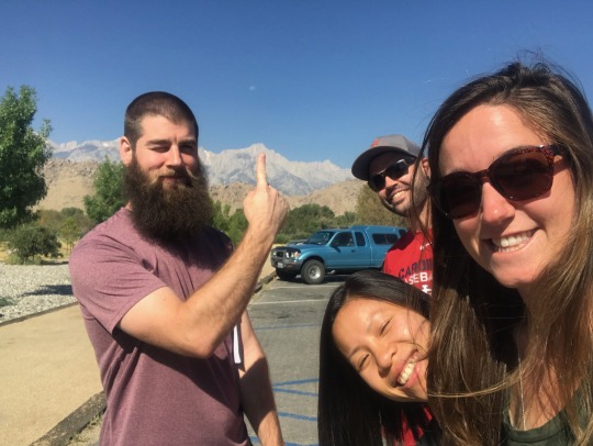
We looked inside some of the posts by faunceblaze and here's what we found interesting.
Average Info
Notes Per Post
18
Likes Per Post
16
Reblog Per Post
2
Reply Per Post
0
Time Between Posts
6 months ago
Number of Posts By Type
Text
10
Photo
6
Link
1
Last Seen Tumblr Blogs


Fun Fact
Post activity is at the highest at 4:00 pm EDT; notes peak at 10:00 pm EDT.
Text
LT 2020: Part I - Preparation
This is the first of two posts recounting our recent hike of the Long Trail, a 272-mile long hiking trail traversing the length of Vermont along the Green Mountains. The northern terminus of the trail is the Canadian border and the southern terminus of the trail is the VT/MA border. This post discusses the lead up and planning of our hike, including our hiker ethic in a pandemic environment. The next post will cover the trip itself (and will have the pics!).
We decided to do a 2020 LT hike back in 2019. The southern 100 miles of the LT are concurrent with the AT, which we did back in 2014. Since then it has always been in the back of my mind to complete the remainder of the LT. It’s also one of the three trails that make up the ‘mini triple crown’ (along with the JMT and the Colorado Trail). We already hiked the JMT, so it just seemed to “make sense” to hike the LT next.
Our friend (”TBD”) also decided to join us on our thru-hike. This would be his first thru-hike experience, which we were very excited to be part of. After considering our past experience on the southern section of the LT, particularly the infamous mud of Vermont, we decided a fall thru-hike would be the best time to go. The advantages were (hopefully) missing most of the mud, bugs would be at a minimum, crowds would be smaller, we would be hiking south with the changing of the foliage, and day time temperatures would be cool for some wonderful hiking. The disadvantages were that we would be limited in daylight hiking hours, and temperatures could dip which could become an issue if we encountered much rain.
Since we have had some considerable experience with thru-hiking, initially there was not much planning done for this trip other than deciding what shoulder-season hiking clothes to bring. We figured we would start out on-trail with a few days of food and just start hiking. However, in early 2020 and the start of the COVID-19 pandemic all of that changed. Now we had to evaluate hiking in a pandemic environment. The first hurtle we encountered was deciding if we would even go on the hike. A typical thru-hike would mean going into small mountain towns, most likely by hitch-hiking, and interacting with a lot of people in small mountain/rural towns as we traverse the state. Given the precautions we were taking to prevent the risk of spreading COVID-19, this type of behavior did not lineup with our hiker ethics. Additionally, if the number of cases did not reduce, then no matter our best-practices it might not be prudent to go. There was absolutely no reason for us to put others in undue risk for the sake of wanting to have a vacation.
As the time neared for the trip, we made the decision that the number of cases in New England, and in particular NH and VT, were at a level that we decided it was an acceptable risk to go as long as we followed some self-imposed guidelines. We were not going to go into towns and potentially risk being a spreader to what are generally insular towns. This meant that there would be no hitch-hiking or resupplying in towns. It made for some logistical hurdles to coordinate our food, but thankfully we were able to organize food drops by TBD’s partner. The major downside to this was having to carry at least 7 days worth of food at a time. Additionally, we would not stay in shelters (which we wouldn’t do anyways, but reaffirmed that decision) and would make sure to practice social distancing from other hikers we encountered.
With these plans, we set out...
0 notes
Text
JMT 2017: Part II - The Hike
Part I of our JMT trip, covering our pre-trip activities, can be found here.
Day 0: We arrived in Lone Pine, CA at around 1:30 am Saturday morning. In normal traffic it is a little over a 7 hour drive. In Friday afternoon traffic...it’s a nightmare. After setting up our tents at the Portagee Joe Campground, we crashed for a few hours until sunrise. Come sunrise, we headed to the local diner to fill up on the largest breakfast we could find. This was probably going to be our last ‘real’ meal for a couple weeks. On our way up to Horseshoe Meadow Campground - where the Cottonwood Pass Trailhead is located - we stopped by the Eastern Sierra Interagency Visitor Center to pick up our JMT permit and got our first look at Mount Whitney! (pictured above)
Horseshoe Meadow (pictured below) is located at about 10,000 feet, so we planned an entire rest day at altitude to help ourselves adjust; and boy am I glad we planned for that. That evening I was suffering the effects of altitude sickness: headache, nausea, loss of appetite, malaise and insomnia. Having to backpack miles after ascending rapidly from 3,000 feet to 10,000 feet would have most likely spelled disaster for the trip.
Day 1: The next morning we woke up feeling much better than the day before. It looks like our bodies had adjusted enough. We started out early because we had a big first day. We hiked about 14 miles to Rock Creek, and along the way climbed Cottonwood Pass, our first of many Sierra Nevada mountain passes. We could start to feel the effects of the elevation as we made our way up: little tougher to breathe and it felt like our muscles were tiring out quicker.
A quick aside to describe the differences between east coast (the AT, especially up here in NH) and west coast hiking. Out on the JMT the trail is maintained for pack animals as well as for humans. As a result, the grade of the trail is much lower than out on the east coast (some great analysis on that here). Additionally, the trail condition on the JMT is generally smoother with less rocks, roots, or scrambles than on the east coast. The flip-side of that is you spend much longer ascending the mountain passes. I noticed that this played on my mind a little bit. I was used to just charging up the mountain and being done with it quickly. Spending a long time winding up switchbacks was at times a downer. Another difference is the exposure. Much of the JMT is alpine, with no tree cover, no clouds, and lots of sand. It took some time to adjust to the sand and constant sun exposure. Ok, back to the trail!
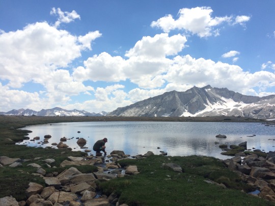
Day 2: Today brought us past some alpine meadows and lakes up to Guitar Lake and the base of Mount Whitney. It was a sunny and hot day, and the 10 miles felt more like 16 - I think elevation was still playing a role. (Not so) surprisingly, Guitar Lake is actually shaped like a guitar! We set up camp near the shore (pictured above) and enjoyed watching all of the marmots hiding in the rocks. There was an amazingly beautiful sunset and stars that night. I think this was the first time that I have ever seen the Milky Way.
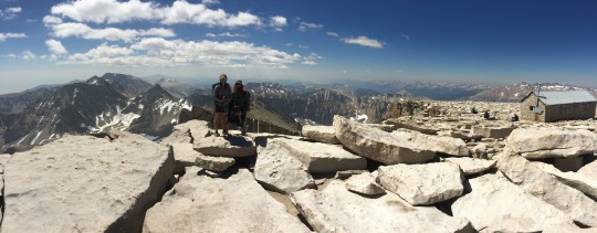
Day 3: We woke up early to start our ascent of Mount Whitney (highest point in contiguous US) and the actual beginning of the JMT. Since we would be coming back down the way we came, we decided to leave most of our gear at base camp at Guitar Lake. The climb up the western face followed an endless path of switchbacks cut into the side of the mountain. We kept our steady pace (”slow is smooth; smooth is fast”) going and made it up to the summit in about 4 hours. The last couple of miles at high elevation really was tough on the lungs. I also think it made our minds just a little bit fuzzy, too. This elevation, 14,505′, is the highest I have ever been. I think we may have felt just a tiny little fraction of what high-altitude mountaineers may feel when they climb mountains. It sure is tough, but the feeling on top is worth it. After celebrating/resting on the summit, we started our descent. We passed many day hikers coming up from the east side of the mountain at Whitney Portal (8,000′), and a lot of them looked much more worn out by the elevation difference than we felt. It really reinforced our decision to start at 10,000 feet and spend those few days acclimating. Our descent went well, and we could really tell the difference in the lower elevations (climb high sleep low, as they say). We got back to Guitar Lake, packed up camp, and hiked a few more miles before pitching camp at Crabtree Meadows. All-in-all it was a 12 mile day and the official start of our JMT.
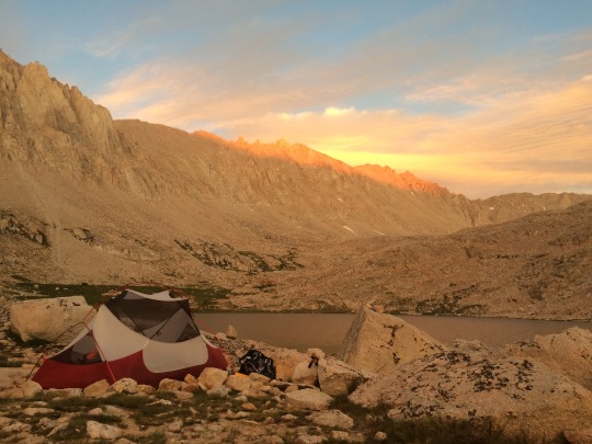
Day 4: We hiked 12.5 miles to reach the base of Forester Pass - the second highest point on the JMT. It was there that we camped at the highest elevation on the trail - 12,495 ft. We were feeling good, and I think that by now most of the effects of altitude have worn off. We camped by a beautiful alpine lake with ice/snow around the rim. The water was freezing cold, but very refreshing after another day of full sun. That evening we watched storm clouds roll through to the south, but thankfully we didn’t get any rain.
Day 5: An early start had us up to the top of Forester Pass before 8 am. On the north side of the pass we hit our first major snow field. The descent down was probably the scariest thing that I have ever done in my life. At one point, any slip in the snow would mean sliding down about 500 feet of vertical elevation right into a boulder field. Needless to say, the pucker factor was quite high. Thankfully, we made it down and back on smooth trail. We hurried along, because that evening we were meeting Kelly and friends at Charlotte Lake! We got to camp early and did some washing up in the lake. Around 6 or so our friends showed up (with our food!) and we had a wonderful evening hanging out.
Day 6: This morning we saw our first (and only) bear on the JMT. We woke up earlier than our friends, so we were just chilling in our tent, when a momma bear and cub come strolling through our camp just a few feet away! They didn’t cause any trouble, and we didn’t give em any.
The hiking today was an easy (low mileage) day over Glen Pass to Rae Lakes (pictured above). We spent the day hanging out at camp and having a good time with friends. A couple guys brought fishing poles and were catching some Rainbow and Brook Trout, and we ended up having a couple fish with our instant mashed potatoes and stuffing that night (they were delicious!).
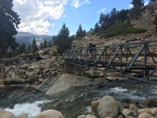
Day 7: Today was another low(er) mileage day that ended with us at another lake (we really like camping at alpine lakes). We had a nice long downhill to a bridge crossing right before lunch. There aren’t too many bridges along the way, most of the time you have to ford the river, but this one was over a large gorge with a raging river, so it was a nice convenience. From there it was a few mile uphill to our destination - Twin Lakes. Randomly, we ran into our friend Nanako along the way! We had heard she was hiking the trail SOBO, but weren’t sure where she was or if we would even end up passing each other. We ended up passing at a small ice field/snow bridge along the river, and quite almost didn’t even recognize her! We hurried to set up camp because there were some nasty clouds/thunder/lightning that was building to our south. Thankfully the storm held off moving towards us and stayed on the other side of the pass. This would be our last night with our friends, so we stayed up playing cards and enjoying the sunset.
Day 8: Today was a big day for us. We tackled two passes in one day! Leaving our friends in the morning was pretty tough. They were still having their wonderful breakfasts and relaxing, so it was tough hiking away from that. We hit Pinchot Pass early in the morning. Mentally we felt down, but we were actually making some good time. The views from the passes are always so beautiful, and it is really neat to be able to look in both directions and see the meadow/bowl you came from and the new one you are heading towards. We had a few river fordings before the long approach to Mather Pass. On the other side was the Palisade Lakes. These lakes were some of the most beautiful lakes on the trail with their snow fields ringing the edges and large cliffs with waterfalls tumbling down. It was getting towards evening so we stopped briefly to eat our dinner and then continued on some more. We descended what is called the Golden Staircase. It is a series of (many) steep switchbacks down into a canyon, and in the afternoon light the rocks and river have a golden glow.
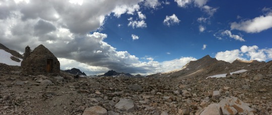
Day 9: This morning we woke up to a strange squawking noise only to see our very first pika. I think we camped close to his home, and he was not too pleased about that. We hiked through Le Conte Canyon on our way up to Muir Pass, named after John Muir. Today was the solar eclipse, but it ended up being cloudy out and we didn’t get to see any of it (bummer!). We had a light rain for about an hour - the first precipitation for us on the JMT. I don’t think we ever went a 9 day stretch on the AT with no rain! Climbing up to Muir Pass was probably the most amount of snowfields that we crossed, but we hit the pass in the afternoon so it was nice and soft for sure footing. There was so much snow melt that at times the trail was basically a very large and shallow river. On top of the pass (pictured above) is the Muir Hut - a stone shelter built in 1930 and dedicated to John Muir. The top of passes generally are not considered a safe place to be during inclimate weather, so I don’t think the hut gets much use these days. We descended the north side and camped at the base of the pass along Wanda Lake with some of the coldest water I have ever felt. It was very welcomed though as our tired feet could use the soak.
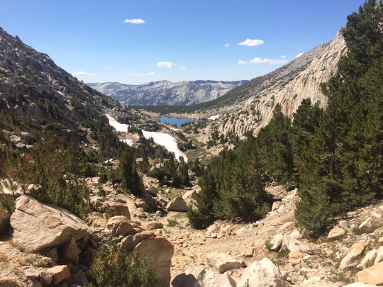
Day 10: Today was our 16 mile “nero”. Typically, a nero means a “near-zero” mile day; however, we consider this day a nero because we finished so early. That morning we passed by the Evolution Lakes, which were really nice, but also strangely crowded (a group of 15+ campers). It was another sunny and hot day, and the trail was mostly exposed today, which was really taking the energy out of us. When we reached Piute Pass Trail and the Piute River (pictured above) we decided to call it a day and have a nice rest. We set up our camp before 3pm! A nice bath and laundry in the river and then it was time to relax and recuperate. We probably fell asleep before 7pm, like a true Grams and Gramps!
Day 11: After our long relaxation day from yesterday, we woke up energized and ready to go. We put down some good miles early and tackled Selden Pass (pictured above) before lunch. We decided to go for our stretch goal that day and get to Lake Edison for a 22 mile day. After some off-trail excursions for some river fordings we started the climb up and over Bear Ridge. Everything was going pretty smoothly until we started our descent. Overhead cracked thunder and lightning, and out of nowhere the heavens opened up on us. It started as rain, but quickly turned to pebble sized hail. We were on the switchbacks of the descent, so there was no where to fast-pitch our tent to get some relief. We huddled under a tree and grabbed our trash bags to try and keep us and our gear somewhat dry, but basically we were soaked to the bone. The trail was a river of chocolate milk. We tried waiting it out, but we were getting pretty cold (and pelted by ice bullets!) so we decided to try and hoof it to a camp spot as fast as we could. Thankfully, we found a decent spot in a few tenths of a mile. We pitched our soggy tent and peeled of our freezing clothes and got into our bags to warm up as fast as we could. Naturally, the storm let up right when our bodies finally began to thaw.
Day 12: We had a late morning today. It’s always hard to get up when everything is cold and wet. Thankfully on the JMT, unlike the AT, we were almost guaranteed a warm sunny day to dry our gear. We packed up, put on our wet shoes, and started out towards Silver Pass. On top of the pass we had an extended lunch so we could air out and dry our wet gear (pictured above.) We also met some SOBO hikers from Massachusetts - small world! The second half of the day took us along Lake Virginia, a beautiful lake in large bowl. We ended our day at Duck Creek excited for tomorrow, because tomorrow we would be arriving at our resupply point in Reds Meadow! We were able to shave off a full day from our planned itinerary. We went to sleep dreaming of burgers and their famous milkshakes...

Day 13: It’s town day! Well, not exactly a town, but a place to get some real food! We woke up early and were grooving on the trail. We had 11.5 miles to go, and we were trying to make it there before they stopped serving breakfast. We pulled into Reds Meadow at 10:45 am, the sign at the cafe said “Breakfast 7 am - 11 am”. Whew! We sit down and promptly order the largest breakfast they had (eggs, bacon, toast, pancakes, hash-browns). After devouring our breakfast, we headed next door to the general store to pick up the few resupplies we need. With the extra day of food, we only needed a couple meals to get us to the end. We then immediately went back to the cafe to order ourselves some lunch! Probably 15-20 minutes had passed since finishing breakfast. Hiker hunger is a real thing folks, and it is scary. After chowing down on cheese burgers, coleslaw, and the best chocolate milkshake you could ever have, we were finally feeling satisfied. Now the hard part begins - actually leaving the wonderful place of filtered water, flush toilets and prepared food! We steeled ourselves, grabbed our packs, and started back to the trail. Along the way we took a detour to see Devils Postpile (pictured above). It is a unique columnar basalt formation formed by lava. It was pretty crowded with tourists, and quite hot that day (90s), so we didn’t spend too long there and kept moving. We tacked on about another 9 miles for what was a big day for us: 20 miles with a resupply. We ended at, you guessed it, Gladys Lake. This lake wasn’t as pretty as the others. We were now getting lower in elevation and away from the pristine alpine lakes. Gladys Lake was a little bit more muddy/boggy, which made the mosquitoes pretty ferocious.
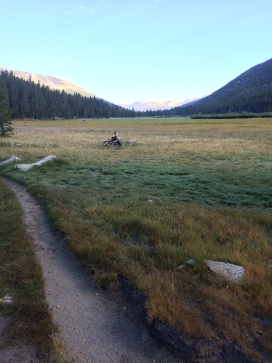
Day 14: Today was the day: we were finally going to make it into Yosemite National Park! We decided to go for another bigger day and do 20 miles over Donahue Pass, which is the border of Yosemite NP. Along the way we passed many lakes that all had gemstone names (Ruby, Emerald, Garnet) and finally Thousand Island Lake (named for all the little islands and not the salad dressing). Our climb up Donahue Pass was a quick one, not because it was short, but because “strong legs and a dash of fear will get you up and over any mountain” (says Grams). Some ominous clouds were brewing, so we kicked it into gear. We also were pretty excited to be entering Yosemite. Mentally, it’s a pretty big milestone in the trip. Once on top of the pass we met a Yosemite backcountry ranger who was there verifying permits and bear canisters. After a brief chat we started down into Lyell Canyon. We hiked until we were completely down from the pass and in the Lyell Forks meadow area of the canyon (pictured below.) This started a pretty long stretch of basically completely flat trail. We pitched camp here so we could have a easy start to tomorrow.
Day 15: A record setting day for us: 26.2, the most miles we’ve backpacked in a day. For some that may be chump change, but for us it was a good day. We zoomed through Lyell Canyon and Tuolumne Meadows; all flat and easy trail. We hike up through Cathedral Pass, which is the last pass we would go through on the JMT. The hike down into Yosemite Valley took us through what looked like recent (past year or two) wildland fire areas. Burnt and charred shells of trees stood as sentinels all around us. And a current fire in the distance left a lingering haze in the valley. We were getting tired as sun continued to melt us, and finally reached our destination of Clouds Rest Trail. There were quite a few people camped here, because it’s a popular spot for those that want to hike either Half Dome or Clouds Rest. We accidentally ended up camping pretty much in the middle of a tour group, but they were pretty cool about it. We were wiped out and fell asleep almost immediately.
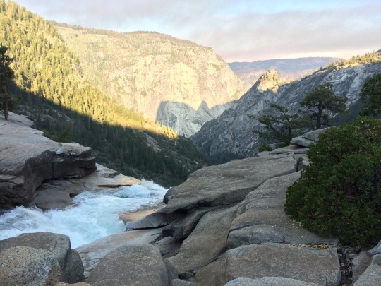
Day 16: The last day. Only 7.1 miles to go to Happy Isles. We woke up extra early today, because we needed to get down to catch the 10 am bus. We packed up in the dark, trying not to wake everyone else up, and started down to Yosemite Valley in high spirits. We had hiked most of this trail before on a previous trip out here, so it was somewhat nostalgic walking the same stretch of trail again past Nevada Falls and the Mist Trail. We reached the Happy Isles trailhead around 8 am and had our mini celebration...we did it! There was some time to spare before heading to the bus stop so we head over to Half Dome Village for a morning sandwich and snacks. A frozen breakfast burrito and ham and cheese sandwich never tasted so good! Although we were done hiking for the day, we still had a long way to go. We hopped on the bus for a 2.5 hour ride around the back roads of the western Yosemite area to finally arrive at the Merced Amtrak station. Two one way tickets to Richmond, CA, please! It was another few hours on the train where we sit, relax, eat our snacks, and talk about the trail. Once in Richmond transferred to the BART subway and got into San Francisco around 5 pm. Just an easy 7 hour commute! We found a hotel in the city (HIE of course), unpacked and cleaned our gear, took about 5 showers each, and stuffed our faces with all of the burritos, beer and tacos we could find. Our time on the JMT had finally come to an end.
Whew! What a long post! Thanks for sticking around for the whole thing. Stay tuned for another post covering our post trail thoughts and data!
0 notes
Text
JMT 2017: Part I - Trip Prep
This is the first of three two installments recounting our trip to hike the John Muir Trail, a long-distance trail through the Sierra Nevada Mountain Range (you can find part II here). The trail extends 210.4 miles from Mount Whitney (the highest point in the contiguous United States) to Happy Isles in Yosemite Valley. With the additional approach hike to Mount Whitney, we hiked around 240 - 250 miles. This first post will provide some background information and our preparation for the trip, the second post will cover our day-to-day experiences on the trail, and the third post will have some post-hike thoughts and data.
Typically, most people hike the JMT southbound (SOBO) from Yosemite NP to Mount Whitney. Hiking SOBO is generally seen as an “easier” hike due to: starting at a lower elevation allowing one to slowly acclimate to the increasing elevation as you head south, having more resupply points in the north allowing for a lighter pack to start, and generally an “easier” trail condition allowing for one to build conditioning as you head south.
Well, after our AT adventure, we are pretty much “NOBO 4 LYFE!” (AKA crazy) and decided to take the unconventional northbound (NOBO) route. Hiking the JMT requires permits (something that is uncommon on the east cost), and getting permits for a NOBO hike is much easier than a SOBO hike. Due to the increasing crowds of hikers wanting to hike the JMT, Yosemite NP has implemented lottery style permitting system along with a daily quota that makes it tough to get a permit. As a result, we decided to start at the Cottonwood Pass Trail Head that is about 30+ miles south of Mount Whitney (what’s an extra 30 miles, right?!). We were easily able to reserve a permit for this trail head for our planned dates back in February, and it even includes a permit to summit Mount Whitney (the official terminus of the JMT). Now the planning begins...
This trip required quite a bit more logistical planning than our AT journey. On the AT we had an open ended schedule, so it really didn’t matter where we were in 2, 3, or 6 weeks. The JMT required actual planning to make sure we could finish on time, but also to figure out our food resupply situation. After studying our trusty guide book, I came up with a sample itinerary that had us completing the trip in 18 days: 2 days to approach Mount Whitney, and 16 days to hike the JMT. Starting in the south meant we had to carry a significant number of days of food with us before we could reach our first resupply point. There are only a few resupply points on the JMT (unless you want to spend a day hiking out to a trail head along with a potentially long hitchhike), and each had their pros and cons. We knew from our experience on the AT that there is a certain amount of “town inertia” that is difficult to overcome when you go in for a resupply. The pull of all those burgers, beers, and beds can make it difficult to leave. For that reason, we chose a resupply point (Red’s Meadow) that was basically on the trail (0.3 miles off trail to a general store) and forced ourselves to not linger too much while there. As a result of that decision we needed about 14 days worth of food to get there (yikes!). We each had a large bear canister (they’re required along most of the JMT), and we could only fit 8 days of food in each of them - and that was working on a calorie deficit too. It looked like we were going to need some help.
The next logistical move ended up killing two birds with one stone. First, how are we going to get to the trail head? We needed to start and end in San Francisco, because we were also attending a wedding there at the end of the trip (all the more reason why we needed to schedule it just right). Getting from San Fran down to the closest town, Lone Pine, is a pretty long trip. A whole day of public transit, or if only we could rope someone else into this party... That’s where our backpacking buddy from the AT, Indie, stepped up. She was able and willing to come out to San Francisco, drive us out to the trail head, and join us at the beginning of our trip in summiting Mount Whitney! She came out with her boyfriend and they also graciously agreed to help carry a few days of food for us during the beginning (thanks Indie and PP!). Win, win, win! 11 days worth of food. 3 more to go.
As I mentioned above, we were tagging this hike on to a trip to San Francisco for a wedding. Our best friend, Kelly, was getting married over Labor Day Weekend. Kelly, her fiancé, and a few of their friends planned on taking a long weekend trip to the Rae Lakes area of the JMT. We were able to work it out to where we would meet them on the JMT on day 5 and hike a few days with them and enjoy some of the beautiful alpine lakes!. They also graciously agreed to pack in a few days of food for us, which now got us to our magic number of 14 days of food (thanks Drewbot for carrying all the food in!). Thankfully, due to the popularity of the region, there were some bear boxes around the Rae Lakes region that allowed us to store this extra food each night, so we didn’t have to worry about having room in our bear canisters.
The last hurdle was planning out how we would get back to the San Francisco when we finished our hike. Although we had a sample itinerary, one thing I know from experience is that they are most often subject to change. We decided to go with good old fashioned public transportation on this one. There are buses that you can catch in Yosemite Valley that take you out to the nearby town of Merced. From there you can catch the Amtrak train up to the bay area, and finally hop on the San Francisco BART to get into the city. Practically a rehashing of Planes, Trains, and Automobiles to get back.
Now we have the logistics set. We have our permit, our sample itinerary, transportation to the trail head, food resupply planned, and transportation back to civilization. Next up is the packing.
We’re not the minimalist of backpackers, but I also think we have a pretty good system for our needs that balances weight, durability, and comfort. Below is what we packed (the clothing list is just for me, not everything was in my backpack):
Backpack: Gregory Z55
Sleeping Bag: EMS Mountain Light 20 - Long
Sleeping Pad: Exped SynMat UL 7
Sleeping Pillow (they’re amazing!): Exped Air Pillow
Tent: MSR Hubba Hubba NX
Bear Canister: BearVault BV500
Clothing (including what I was wearing):
Quick Dry T-Shirt
Shorts (with liner)
Sun Shirt: REI Co-op Sahara Tech
Hiking Socks: Wright Socks - 2 pair
Compression Socks: Sockwell
Rain Jacket: Marmot PreCip
Mid-weight Wool Layer
Smartwool Beanie
Wool boxer-shorts
Baseball Cap
Sunglasses
Bandanna/Kerchief
Shoes: Brooks Ghosts
Cook-set:
Stove: MSR MicroRocket
Fuel Canister: 8 oz.
Pot: MSR Titan Kettle
Spork
Cleaning Rag
Water:
Bladder: Platypus 2L Big-Zip
Filter: Sawyer Squeeze (in-line with bladder)
Clean Bottles: Platy 1 L
Miscellaneous:
Guidebook: JMT Pocket Atlas
Journal pages + Pen
Compass
Headlamp
Multi-tool: Leatherman Squirt PS4
First-Aid/Toiletries:
Toothpaste
Floss
Toothbrush
First-aid kit (ibuprofen, band-aids, pepto, antibiotic ointment, tweezers, nail clippers, needle, thread)
Trowel: Deuce of Spades
Toilet paper, hand sanitizer, wet wipes
I think that about covers most everything. There may be a few other small incidental items I forgot to mention in the Misc. or First-Aid categories.
Our food was pretty much the same the entire trip (and not all that exciting). We supplemented a few different dinners (Mountain House or instant potatoes) on a few of the days that our friends carried in food, but otherwise this is pretty much what we ate the entire time:
Breakfast:
Oatmeal - packaged at home with nuts, flax, and brown sugar.
Lunch:
Tuna packets, peanut butter
Dinner:
Ramen (Sapporo Ramen is the best!)
Protein powder
Snacks:
Clif Bars, Snickers (a few per day)
I think that about wraps up our pre-trip planning. Next up will be a (big) post covering our the actual hiking!
0 notes
Photo

“The Hiker” -Esao Andrews
H/t to Trevor for sharing!
“The mountains are calling, and I must go.” -John Muir
0 notes
Text
Springer-versary!

Where were you one year ago? We were just starting our journey.
It doesn't seem that long ago. I remember the drive up and the butterflies in my stomach. Where we prepared? Would we make it? Was this an utterly dumb life decision?
Looking back on it now I can’t help but laugh at myself. It was the best decision ever! I would make the same choice 100 out of 100 times.
I want to encourage you: don’t wait until the end of your life to chase your dreams. There is no better time to do those things that are most meaningful to you in life than right now.
2 notes
·
View notes
Text
Section Hiking The A.T.
Due to many different constraints (job, finances, desire, etc.) many people feel that a year long thru-hike is not feasible for them, but they still dream of one day completing the entire trail.
They then become a "section hiker". These are hikers that go out for some length of time and hike a section of the AT. The beauty of it is that you have the flexibility to hike wherever and whenever you want. Only want to hike when the flowers are blooming or the leaves are turning...go right ahead! You can plan to go in the optimum season for each section; avoid the crowds and unpleasant weather.
With that in mind, I decided to come up with a list of some section hikes that I think are really nice. These hikes hit a lot of the famous spots along the AT, or the spots that are "worth it" in terms of views. They are compiled in this spreadsheet here.
It lists the section, mileage, maps for start and ending trail-heads, a description of the major points of the hike, and some links to things of interest like hostels.
Also listed at the top is general information about the AT: shuttles, trail updates, and permitting for some of the parks.
This list is for everyone, but also for ourselves. These are areas of the trail that we loved and look forward to going back to and exploring again.
0 notes
Text
Why the AT Is so Incredibly Easy; Or, Why a Lot of People Like to Think It Is
Many people look at the Appalachian Mountain Range and have the following thought process:
"Hmm, those don't look to be all that tall. What's the highest elevation...not even 7,000 feet!? Wow, practically half the US is higher than that! That AT must be pretty easy"
In response, I did some digging around for total elevation gain for the big 3: Appalachian Trail, Pacific Crest Trail, Continental Divide Trail.
Here is what I found:
Appalachian Trail, 2200 miles: ~515,000 - 529,051 ft
Pacific Crest Trail, 2700 miles: ~489,418 ft
Continental Divide Trail, 3100 miles: ~400,000 ft
Data for the CDT is limited since the trail is not complete. Summing up all of the available data (which does not include New Mexico and some other small stretches) is 271,225 ft. I think the 400k ft is a reasonable assumption.
The elevation of Mount Everest is 29,029 ft. Hiking each trail is like climbing this many Mount Everest's:
AT: 18
PCT: 17
CDT: 14
While on the AT you ascend over 97 miles! To put that in perspective: hiking any of these trails is enough elevation gain to put you into outer space. The AT puts you right at Low Earth Orbit.
It is clear that on a mile-per-mile basis the Appalachian Trail is steeper (which is just one indicator or ruggedness). This, however, by no means devalues any of the other trails or their thru-hikers. Thru-hiking is an amazing accomplishment and takes an incredible amount of strength. All trails are equally challenging in their own regard; hiking on the lowly east coast is just as difficult than hiking out west.
3 notes
·
View notes
Text
Post AT: Keeping the Fire
It's easy to fall into post-AT depression. Living simply in the wild, and then coming back into...all of this. We try hard not to be re-assimilated (I mean, who wants to go back into the Matrix amirite!). In efforts to not loose that loving feeling, we make sure to spend time daily outside in nature. Even if it's a short walk.
In this vein, there is a new goal for 2015. Not quite as ambitious as 2014's goal of finally realizing a life-long dream, but a pretty awesome goal nonetheless that will keep our passion for the outdoors satisfied and still help us maintain that "hippy-dippy, long-haired, frolicking barefoot through the trees"-ness.
Our goal is to complete all of the 4000 footers in New England. There are 67 in all of New England and 48 of them are in New Hampshire alone. In the course of hiking the AT we have given ourselves a head start. Of the 67, we have climbed 33, and the top 12 highest in New England. Thanks Appalachian Trail Conservancy for always finding the tallest thing around!
1 note
·
View note
Text
Appalachian Trail Questions Part II: Hitchhikers? Pick-em up!
Here we’ll answer some more questions about hiking the trail, and also some about after the trail.
Did you hitch-hike?
Maybe to the displeasure of all mothers out there, yes we did hitch-hike. And I would hitch-hike again, too! We always had at least 2 people (grams and I), and sometimes as much as 6 of us looking for a ride somewhere. This definitely made the decision to throw a thumb out much easier. I can understand a single hiker being a little apprehensive about hitch-hiking (and some of the ladies that were thru-hiking would only hitch if they had a partner). Most of the time it’s the people that pick us up that are more worried (how many times do you pass someone on the road and think “bad news bears”). Here are some tidbits we learned along the way:
-Being a couple and married is definitely a help. Strangers feel more comfortable (I guess they never heard of Bonnie and Clyde)
-Hitching with a dog is tough. We saw a few people hanging thumbs and paws trying to get into town, and we usually saw them as we were riding by after being picked up. Lots of people love man’s best friend when you’re out hiking. They just don’t want those dirty little paws in the back of their car.
-A majority of people giving us a ride either hiked the trail before or knew someone who did. There were a few occasions we were picked up by someone with no/limited knowledge of the AT, but most folks were quite familiar with thru-hikers.
-Hitching in the rain/snow/cold is typically easier. I like to call this the Sad Puppy Eyes Effect. How can you say no!?
-When hitching with women, the guys stand in the back. Oh yeah, and let that hair down.
-It doesn’t matter what you are driving-we’ll make it work! Seven (7!) people in a geo metro 2 door Toyota Echo (thanks Professor Mouse!)? Make it happen, cap’n. The back of your white panel van has shag carpet/no seats/filled with scrap wood? Sure beats walking! You have to stop first to feed the neighbors horses? No problem.
-Trucks are the best bet for getting picked up. Minivans are about the worst.
Best Hitchhike: Probably the Lexus SUV giving us a ride back into the Nantahala Outdoor Center. Or maybe the Audi SUV in Vernon, NJ.
Worst Hitchhike: Laurel Trading Post back to Devil’s Fork Gap. Hill country folk who about drove off the mountain and every other word was “Roll tide man. Roll tide.”
Strangest Hitchhike: Either getting picked up in Vernon, NJ and getting awesome trail magic (like a cook-out and sleep over), or picked up in the rain in Stratton, ME by a Maine Game Warden being filmed for North Woods Law.
Grooming and Hygiene
Old “Scratchyman” asked a question in the last post about shaving/grooming. Most of the guys hiking on the trail just let the hair go. This is also what I did. There’s not too many times in life you can get away with going full caveman. You can see in our Katahdin picture that it got to be pretty large (I received some awesome compliments on the hair/beard along the way including “best beard I have ever seen” from a 70 year old lady in Maine). There are some that really hate the beards and would only go a week or two before shaving. It’s really a “to each their own” kind of situation. I’ve never been bothered by the beard so I was fine with letting it go. Also, coming from a line of quite hairy men made taming of the beard pretty tough on the trail.
Other hygiene is sometimes tough to keep up as well. Deodorant is usually non-existent on the trail. Everyone is going to smell no matter what after 12 hours a day of sweat, so don’t bother carrying the weight (just bring more food!!). Washing in rivers and lakes is always nice-even if it’s just splashing some cold water on your face. One of the most important things we did was soaking our feet. It helped reduce swelling and hot spots-and felt amazing! Showers were had whenever you went into a town and either stayed somewhere or there’s a hostel that lets you take one for a few bucks. It probably averaged to a shower a week. Maybe that’s why thru-hikers are referred to as “Hiker Trash”. One of our more shocking anecdotes was when we walked through the entire state of Vermont without a shower. Fun times!
How much did your pack(s) weigh?
In general they weighted anywhere from 15-30 lbs. This is pretty typical for thru-hikers. It all depends on the food and water you carry. A lot of folks are starting to go ultra-light, meaning their packs are usually no heavier than 15 lbs. It makes it a lot easier hiking along, but the equipment you have will cost more, probably be less durable, and you will have zero comforts (maybe not even a tent). We decided it was a good idea to distribute the weight between two people and have a little bit more comfort (this is all relative-some thru hikers would even bring camp chairs)
What was in your pack?
In the future I hope to post some more in depth gear reviews, but here’s a list of things we brought:
Backpack (Gregory Z55 and J50)
Tent (Hubba Hubba NX: rain fly, poles, stakes, no ground cover)
Sleeping bag (EMS 20° for winter, emergency bivy for summer)
Sleeping pad (Exped Synmat UL 7)
Camp Pillow (Exped blow-up, this was by far the best comfort I had the entire time)
Stove with Fuel (Trangia alcohol stove for about 1600 miles, then a MSR MicroRocket canister stove the rest of the way)
2 pots
2 sporks
Headlamp
First Aid kit (home made some band aids, gauze, anti-bacterial, sewing needle, thread, etc.)
2L water bladder (Platypus)
Water Filter (Sawyer Mini)
Trowel (never leave home without it!)
Toiletry Kit (Toothbrush/Toothpaste, floss, nail clippers, tweezers, chapstick)
Towel
Guidebook
Sketchbook/journal
Compass
Knife/mini-leatherman
Trekking poles
Phone/charger
Crocs (make the best camp shoes/water fording shoes)
Stuff sacks (to hold the various things)
Clothes (shorts, socks, t-shirts, long sleeve, vest, rain jacket, hat)
Shoes (Brooks Running shoes or Salomon Trail Runners)
Gaiters (OR then changed to Dirty Girls)
Garbage bag and ziplocs (these are so helpful in keeping things dry)
S-Clips/Carabiners
Book (pocket Bible, Breaking with Moscow)
Food
I think that is about everything. The biggest variable is food. In general I would carry most of the base weight and grams would carry a lot of the food, so over time her pack weight would lessen and on a town day it was quite light.
It may seem like a lot of stuff, but it really isn’t. It was our entire lives on our backs. We had a sense of pure mobility and self-sufficiency with those packs on. Like we could go anywhere in the world with nothing stopping us. Of course we needed access to water, food, and fuel, but we could carry a good bit of all three of those. You get used to your pack and hiking without it is kind of strange. You almost feel off-balance. When you get your pack on you definitely feel a “Hello old friend” comfort.
What are some takeaways from the trail?
There are so many things the trail does to you. Everyone is out on the trail for just as many reasons. Here are a few things that impacted us:
-The trail builds self-confidence. When you are on top of the highest peak in the area and you look across the horizon and think “I just came from as far as the eye can see, and I’m going even further” you can’t help but have a little bit of heart swelling. Knowing that you are out in the wilderness truly living on your own gives you a great sense of pride and healthy dose of rugged individualism.
-You slow down. The act of walking for 5.5 months all day, every day, really slows your life down. You’re not in a hurry anymore. You take time to notice things around you and not be so reactive to every little thing that happens.
-You don’t sweat the small things and your definition of a “big deal” changes. Our major concern was “where is our next water source.” Not even “where are we going to sleep tonight” was that big of a deal. This brings major perspective to life and what we should hold important and what we should get worked up about.
A lot of people are on the trail to walk off something. Many times its soldiers with PTSD (see the Warrior Hike) that are out there to “walk off the war.” Or it is people with broken homes or they have lost their way in life. Meeting these people and talking with them is one of the most rewarding aspects of the trail. Everyone out there is having a life changing experience and it only serves to strengthen the thru-hiker bond.
3 notes
·
View notes
Text
It's, Like, Far Out, Dude
Sometimes it's difficult to fathom just how long the Appalachian Trail really is, and even when we look back on our adventure it sometimes doesn't quite sink in that we covered 14 states.
I like to visualize things, so one day I decided to see just how far you could get across North America if you walked around the same miles as the AT. For some reason it's a lot easier for me to visualize the distance in a east-west sort of way. The 2014 official length is 2185.3 miles. Figuring around 10% extra miles for side trails (to towns, to water, to views, etc.) gives a total of 2400 miles. Here are some examples:
Boston, MA to Salt Lake City, UT: 2,366 miles
Atlanta, GA to San Francisco, CA: 2,472 miles
Washington DC to Las Vegas, NV: 2,407 miles
Key West, FL to Prince Edward Island, Canada: 2,274 miles
I think one part of why it doesn't seem like the AT should be that long is, when you look at the length of the east coast, you see that to go from the southernmost point of the continental US all the way up to the coast of Canada is just past the official length of the AT. So when we think of the AT that runs from northern Georgia to central Maine it's easy to think its not all that long.
The distance is in the details. The AT follows the Appalachian Mountain Range and likes to take a very curvy path as it winds it way northwards. If there is a mountain nearby, the AT will most definitely go out of its way so you can climb it. Sometimes determining which way the trail goes is not straight forward, so one of the sayings on the AT is: "if you're ever in doubt the AT goes UP!"
2 notes
·
View notes
Text
Appalachian Trail Commonly Asked Questions Part I Or: Did You See A Bear?
We have gotten a lot of questions concerning the AT, so I feel like I should take some time and answer as many as I can. Please(!) leave more questions in the comments, and I’ll do another post with more stuff.
Here we go!
What is the Appalachian Trail?
-It is a hiking trail that starts on Springer Mountain, GA and ends on Mount Katahdin, ME. Originally the beginning was on Oglethorpe Mountain in Georgia, but was moved because the mountain was being over developed.
How long is it?
-The trail length for 2014 is 2185.3 miles. Each year the official length changes slightly due to trail maintenance and re-routes.
How long does it take to thru hike?
-It took us 170 days to finish. We started March 13th and ended August 29th. The average time to finish is around 6 months.
Did you do any training in preparation?
-We did not do anything in particular to physically train for the trail. We are pretty active and do a lot of hiking and backpacking, but there was not a dedicated “AT Preparedness Plan.” There is no training that can prepare you for the everyday pounding that your body takes. Mental preparation is very important, though. This is not just a “walk in the woods.” You have to be prepared for the good and the bad. Some days are just plain miserable, but you still have to keep going. Finding the beauty in little things, learning to slow down, and accepting that some things are just out of your control are all attributes of a thru-hiker. (More on this later)
Did you take a cell phone?
-Yes. We brought one cell phone for the two of us-an iPhone. This doubled as our camera too! We would keep it on airplane mode the majority of the time 1: to save on battery life and 2: because we came to the woods to be in the woods and not talk on our phone. Pretty much everyone on the trail has a cell phone. There is very good reception, too. Verizon works the best with coverage pretty much along the entire trail. Some people we hiked with were able to call home, if they wanted to, practically every night. We would usually use our phones when we got into towns to update everyone and our blog and to charge it up.
Did you take a gun?
-No. This is a question we get from a lot of people-probably the most asked question. Whenever we talk with other thru-hikers about what is the most asked question, this one comes up the most. The vast majority of thru-hikers do not carry a gun. Some do carry bear-spray (typically not because of the bears, but for people protection). We never ran into a situation where we wished we had a gun, or bear spray even. The odds of some sort of human attack in the woods is most assuredly lower than living in your own city. We get the response, “I’d rather have a gun and be sure, than not have one.” Our response is simply, what if the other person gets your gun. What then? If they already have a gun, I’m not going to be pulling out my gun and starting some Call of Duty style shootout. Additionally, I’m not going to carry a gun on my person. At most it would maybe be in an outside pocket of my pack. Trying to access that when there is a crazy person attacking is going to be pretty tough, and most likely either I or my spouse will get injured. The risk-reward for carrying a gun is just way too high. The trail has such a wonderful community of thru-hikers that look out for each other and really care. This is the best defense.
How do you get food?
-You have lots of opportunities to resupply along the trail. Typically every few days you are close enough to a town or store to get supplies. In the beginning we would supply about every 3-5 days. After a while this crept up to carrying about 5-7 days’ worth of food. This was mainly because we wanted to put in more miles and stop in towns less frequently.
What food did you eat?
-Ramen. Lots and lots of ramen. We look for calorie dense foods and ramen is pretty good and is easy to carry. Peanut butter, Nutella, snickers, and olive oil are some of the best. With all of the calories burned (upwards of 5,000 per day) we have to eat a lot of food. Basically everything that is edible we just shove into our mouths. Unfortunately, it’s hard to eat that many calories. Carrying that much weight is tough, and we get tired and sometimes eating just isn’t that high on the list. Most of the time we run a calorie deficit and try to make up in towns as best as we can. Here is a typical day diet:
Breakfast: Pop-Tarts or Belvita bars. Maybe a Cliff Bar or snickers
Lunch: Peanut butter or tuna fish on tortilla. Another Cliff Bar. Probably some junk food snacks: Snickers, some chips or cheez-its.
Dinner: 1.5-2 packets of ramen, olive oil, maybe some peanut butter or summer sausage. Basically anything that’s left over for the day goes in. Another Cliff Bar or snickers. (Side note: a huge thank you to Cliff Bar for sending me over 200 free Cliff Bars!)
Snacks throughout day: 3 more Cliff Bars or snickers.
We liked to carry cheese, but had to stop some during the hot weather. Near the later sections of the trail the weight factor of food goes out the window and we do weird things like walk out of a town with 7 avocados and a sixer.
We also have been known to walk into a diner, order breakfast, and then immediately order lunch. That look when the waitress asks “Breakfast or lunch menu” and we say “Both?”
Consequently, if you ever provide trail magic for thru-hikers: we will eat anything! I only met one picky thru-hiker (honestly, who says no to a warm budweiser at 8am??).
What is Trail Magic and Trail Angels?
-Trail Magic is anything that happens along the trail that is unexpected and great. Trail Angels are the people who provide Trail Magic. It can come in many forms. Mostly it is food. At road crossings there may be someone that is providing food for the thru-hikers. It can range from just a cooler left there with drinks and snacks to a group of people camping out for a weekend and cooking tons of amazing food. Other times it is someone offering you a ride into town, or back to their house even to do some laundry, a shower, and a nice bed to sleep in! Any act of kindness is Trail Magic. Anyone who does it is a Trail Angel. We encountered a lot of magic along the trail. The kindness of random people to strangers is overwhelming and is part of what makes the AT such an awesome place.
What was your favorite part?
-There are lots of awesome places along the AT. It can be hard to pick out what is our favorite. There are a lot of places we would like to revisit for various reasons. We love to be out in the wilderness (guess that is pretty obvious), so the entire trail always had something new and amazing to see. Some areas that really stand out that I’d recommend to other people are: Roan Mountain and the Humps, Grayson Highlands, The Whites, Maine (yes, the entire state of Maine). There’s so many other parts that were awesome too that are just hard to pin point. Like the stealth-campsite outside of Palmerton, PA on the ridgeline that had an amazing sunset. Or the Antlers Campsite in the 100-mi wilderness. Or descending the Dragon’s Tooth in a torrential downpour and almost dying (ok, maybe at the time that one was under the least favorite part).
What is the most difficult part?
-Again, this is very subjective. You can come into a shelter area with other thru-hikers and ask what they thought and get every kind of answer. Some people hate PA for its rocks (“Rocksylvania”), or hate VT for its mud (“Vermud”). Other people love those sections. We generally found New York to not be all that enjoyable. This was due to exhaustion starting to set in and the always changing elevation. NY is a low elevation state along the AT, but you go up and down a lot. And it’s over very large rocks so you are doing a lot of scrambling. It just wears you out. The Whites are pretty difficult as well, but the awesome views help it not be so bad. Maine is probably the hardest part (at least southern Maine). You’ve hiked 1900 miles and now you have the hardest aspects from every part of the trail: large elevation gains, steep, rocky, scrambles, roots, roots, more roots, oh look there’s some rocks amongst the roots. But Maine is so beautiful! Go see Maine! Really. It is so worth it! Why are you still here? Go! Just don’t trust the roots.
So did you actually see any bears?
-Yes! We saw a few bears, mostly in Shenandoah National Park. Surprisingly we did not see a black bear in Smokey National Park even though they have a population density of 2 per square mile! Plenty of other hikers saw them there, though. The bears really don’t want anything to do with us hikers and just wander off. We never had a bear in our camp (as far as we know) nor a bear get into our food. It’s always recommended to either bear bag your food (hanging from a tree in such a way that bears can’t get to it. Black bears are excellent tree climbers, so you have to be sure to do it right or it’s basically a nice piñata for them or use bear cables or poles which are mostly in the national parks). We used some of the bear cables in the beginning because there were so many people and sometimes they aren’t very conscious of how they are handling their food. But after the Smoky’s we didn’t hang bear bags or anything. We just slept with our food bag in our tent (not sneaking a snickers in our sleeping bags, this isn't boy scout camp). I know it may sound bad, but we really had no issues and I have no problem continuing the habit. Black bears aren’t these man-eating, ferocious beasts that are lying in wait just to ambush you. A poorly hung bear bag is worse than sleeping with a food bag in your tent.
1 note
·
View note
Link
For those interested, here is a link to a spreadsheet giving a breakdown of our AT hike. If anyone wants any other specifics just let me know.
We hiked for a total of 170 days. This gives an average mileage of 13 miles/day. We also took 21 "zero" days (meaning we hiked no miles that day). The result is 149 hiking days with an average of 15 miles/day actually hiked.
I also have the average mileage per state to give a very rough sense of trail "difficulty". It is not a great indicator of actual difficulty, because so many factors are involved (weather, physical condition, mental condition, trail condition, etc.) that spans across state lines. However, throwing out GA and NC/TN because they were in the beginning of the trail when we were finding our "trail legs" does give an OK sense of general difficulty. New Hampshire and Maine were pretty tough for their varying reasons, and we also found New York to be surprisingly difficult as well. After that it is pretty much a toss up as to who finds which state easy or hard. Some people loved Vermont while cursing whoever laid the trail in Pennsylvania.
That's the crazy thing about the AT: you can ask a group of people the same question and get all unique responses. I think that is why the mantra "Hike Your Own Hike" has become so popular. It is almost useless to ask someone what they think about a section of trail. We've had people come by and say "Oh, the next section is just awful" only for us to feel the complete opposite. You're better off just forming your own opinions as you discover each new section of the trail and not worry about what other people may have to say about it. I remember in the beginning of the trail, as I would be climbing a mountain, I would ask people I passed if I was close to the top. As if I would decide to stop if the top was far away? Of course not! That quickly faded and by the end I found it funny to see a lot of the South-bounders asking me if they were close to "the top". I would just tell them that they'd reach the top of something eventually as long as they kept walking.
Coming up next I'll try and answer some FAQs about the trail.
2 notes
·
View notes
Photo


Happy Katahdin Day!: 29 Aug From the campground, we were 15.1 miles to the summit of Baxter Peak. Typically, most thru-hikers hike 10 miles into Baxter State Park and stay at a hiker shelter called The Birches near Katahdin Stream Campground, and then the next day summit Katahdin. We decided that we just couldn't wait another day. We figured that we might as well go out with a bang on the AT, which meant doing a 20 mile day with a little bit of night hiking from the campground, up Katahdin to Baxter Peak, over the Knife Edge, and down the north side of Katahdin to Mama Hoot waiting for us on the other side. So at 3:00am we woke up and set out from the campground just after 4am. The trail to Katahdin Stream Campground at the base of Mount Katahdin was a really nice stretch of trail and made for some easy night hiking. We reached the base of Mount Katahdin around 8am and registered with the ranger there. Grams and I were thru-hiker numbers 356 and 357 to summit. This is pretty close to our Harper Ferry's half-way numbers of 393 and 394. The weather was absolutely beautiful! You could not have asked for a better summit day. The temperature was in the low 70's with a slight breeze and not a single cloud in the sky. I think we are the luckiest thru-hikers ever. We walked the entire 100 Mile Wilderness and summited Katahdin without being rained on at all! There were a couple sprinkles early on, but it barely counts as rain. A whole week in Maine without rain? That's insane! It took us a little under 4 hours to climb up to Baxter Peak. There are some definite rock scrambles to get up to the Tablelands but it wasn't much different than what we encountered in the Whites or southern Maine. You walk for about 1.5 miles being able to see the actual summit and finish sign. As you reach the summit of Baxter Peak, you see the sign and the last large rock cairn: the northern terminus of The Appalachian Trail! There were a lot of day hikers up top, but also a few thru-hikers. Some we haven't seen in months, and others we just met. We were able to take our Katahdin pictures and then sit and reflect on everything we have done over the past 5.5 months and take in the inspiring view from the top of Baxter Peak. After a couple of hours on top and a wonderful lunch of our favorite junk foods and sodas, we had to hike the "unseen" finish of the AT. Hiking back down the mountain. Thankfully, because Mama Hoot was on the other side, we were able to hike straight over Mount Katahdin. This meant going along the Knife Edge. This is a famous stretch of trail the goes from Baxter Peak over South Peak and on to Pamola Peak. The narrow trail is a 1.1 mile rock scramble along a very sharp ridgeline that has steep drop offs on both sides of the trail. At times the trail is very narrow, and there were a few moments of holding our breath as we traversed over to Pamola Peak. The last section included a steep down-climb and climb up a chimney to Pamola Peak. It was a pretty tough but exhilarating climb and we are so happy that we were able to do this section of trail. After hitting all of the peaks, we hiked back down to the parking lot and got there just as dark was setting in at 8pm. All-in-all we hiked 20 miles over 16 hours. One epic Katahdin Day! Reaching the end of this trail brings a lot of different feelings. I don't think the magnitude of what we have done will set in for quite some time. Everyday for 5.5 months we woke up with the one goal of reaching this peak, and now we are here. We are so elated, relived, even a little sad. To thru-hike you face much adversity. The body will hurt, the mind falters, and emotions will weigh heavy, but in the end the call of the White Blaze kept us moving forward ever toward our goal: Katahdin. A huge thank you to everyone that has supported us throughout this adventure: our parents, siblings, family and friends! Your encouragement and support has been amazing; we couldn't have done it without you! Stay tuned for more reflections on the trail, gear reviews, FAQs, stats and more!
1 note
·
View note
Photo


100 Mile Wilderness: 23-28 Aug Maybe one of the most famous sections of the entire trail. We have 114.5 miles left until the summit of Katahdin! A lot of people get intimidated by the name of this section. In reality, this section is not really any different than any other section. Yes, there are not any towns you can easily hitch into while in the wilderness, but it's not like you are out all alone bushwhacking your way to Katahdin. You do need to carry enough food to get you to Baxter State Park, which is typically the longest resupply that you carry on the trail. We wanted to be a little on the safe side, so we carried about 7 days worth of food. We saw lots of day hikers and weekenders while in the wilderness. It isn't that difficult to drive into and do sections. We were able to see some of the most beautiful ponds and lakes. The water is so clear here! Some ponds have nice cold water, and others have warm water-its like being in a spa. A little over half-way through we got our first view of Mount Katahdin from on top of White Cap Mountain. It was so awesome, and kind of strange, to finally see our destination. We have traveled so long just dreaming of Katahdin and what it will look like, and now we finally can see our final trail-head! We sat on top of White Cap that evening and ate our dinners in view of Katahdin. It was magical. Indie's dad, Hoot, joined us on this last section of the trial. Her mom was camped on the other side near Baxter State Park waiting for us to come out on the other side. It was refreshing to have someone hike with us and give a little boost of excitement to our final stretch. We pushed through the wilderness in 6 days. Hoot gets some major props for coming out on the trail and doing some big miles with us through Maine! As he likes to say it, I slowly put the ratchet on him with the mileage: 10.4, 15.6, 17.1, 19.7, 21.7, 14.9. But he did great, and we were able to really enjoy our time in the wilderness! Once out of the wilderness we reached Abol Bridge and the campground. We grabbed some awesome food at the nearby camp-store restaurant, and rested up on our Katahdin Eve for our victory lap tomorrow!
0 notes
Photo


Maine: 09-22 Aug Southern Maine is considered one of the hardest sections on the entire AT. The trail is very rugged with lots of rocks, roots, mud, and more roots. A couple contributing factors that make southern Maine so tough is that we have walked 2000 miles and just came over the Whites which are their own challenge. By this point, our bodies have taken a pounding and we are just flat out tired. The climbs up and down the mountains are very steep and grueling; a common phrase is: "The trees are your friends". You end up using the trees to pull yourself up or lower yourself down the trail. Even though it is hard, Maine is still one of the most beautiful and awesome states on the entire trail. The "hardest, or most fun, mile on the AT" is through Mahoosuc Notch. This stretch of trail is just a pile of large boulders that you climb over or crawl under. It's a fun and interesting section of the trail. We didn't think it was the hardest mile, but it definitely took us the longest amount of time-partly because we were having too much fun playing in the rocks! It is known for having ice year-round down inside the cracks between the boulders. We got some awesome trail magic at Grafton Notch. There were some AMC hikers out for a weekend trip and as they were leaving the parking lot they offered us a ride into Bethel, ME. When there's a chance to grab burgers, pizza, and beer you don't say no! We ate at this small pub in town, and they were even so kind as to buy our meals for us! Talk about great trail magic! It took us a few hitches and a couple hours to get back to the trail head, but it was well worth it. The next week or so was through a few mountain ranges that make up the Rangeley-Stratton stretch: Bemis, Saddlebacks, and Bigelows. They provide some amazing views of Maine and all of its beautiful ponds and lakes. We stopped into Rangeley, ME which is famous for being half way between the equator and the north pole! After a few more days we were hitching into Stratton to get some food and small resupply. After standing in the rain for a while and watching the cars zoom by a truck pulls up, rolls down the window, and a TV camera pops out! Turns out, it is a game warden that is being filmed for the show North Woods Law (airs on Animal Planet). When they saw three dirty hitchhikers they must have thought it might make for a decent segment. We hop in the back of his truck and he gives us a ride down into town. After an informal interview, we sign some release forms and move on our way over to the diner to eat some brunch. I guess we may be on TV in the fall when the new season airs? One cool part of the AT is in Caratunk, ME. The official AT crosses the Kennebec River via a canoe ferry. It is the only part of the trail you don't have to walk! There are multiple rivers requiring fording, but this is the only one to have a shuttle service! The ferry has been in use since the inception of the AT, because there are multiple damns up river that can release water and the level can rise faster than you can ford the river. After a free ride up to the Northern Outdoors Restaurant and Brewery we were on our way to Monson and the beginning of the 100 Mile Wilderness!
0 notes

Photo


New Hampshire: Wildcats The first few picture are from Mount Madison in the morning. Amazing. The last section of The Whites along the AT is the Wildcats. Most people ski down these mountains during the winter time, but we get to see and climb them in the beautiful summertime. It was some very rugged terrain with lots of steep rock scrambles. This is where we pass our last AMC Hut: Carter Notch. Since it's kind of off the beaten path they are usually really cool to thru hikers. When we passed through they gave us a huge bowl of leftover eggs, peaches, and oatmeal! Only one more day and then we're in Maine! The last state! We'll pass 1900 miles and have less than 300 miles to go!
1 note
·
View note