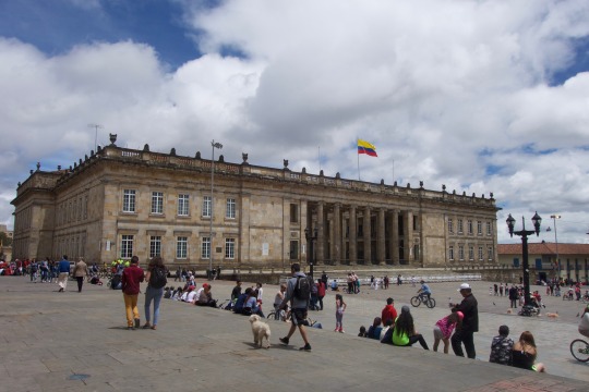
#salkantay trail map
Explore tagged Tumblr posts
Visit Tumblr Blog
Explore Tumblr blogs with no restrictions, modern design and the best experience.
Last Seen Tumblr Blogs


Fun Fact
After the announcement of the deal with Yahoo!, there were 170K signatures of unhappy Tumblr users petitioning to prevent the sale in 2013.
Text
Salkantay Trek Travel Agency: Explore with Alpaca Expeditions
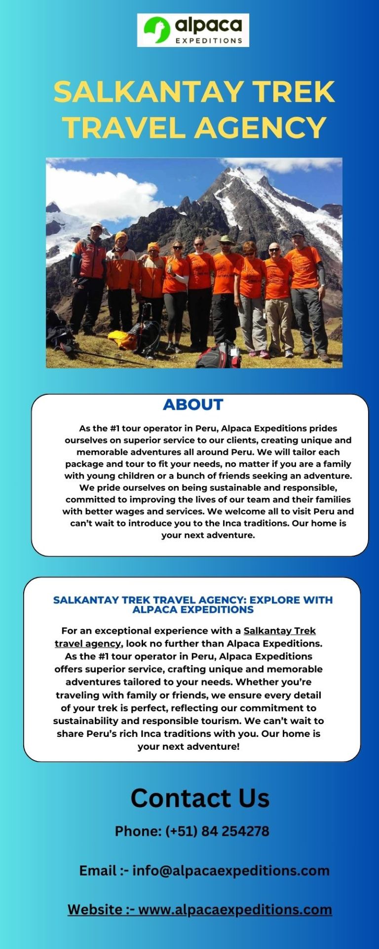
For an exceptional experience with a Salkantay Trek travel agency, look no further than Alpaca Expeditions. As the #1 tour operator in Peru, Alpaca Expeditions offers superior service, crafting unique and memorable adventures tailored to your needs. Whether you’re traveling with family or friends, we ensure every detail of your trek is perfect, reflecting our commitment to sustainability and responsible tourism. We can’t wait to share Peru’s rich Inca traditions with you. Our home is your next adventure!
#inca trail vs salkantay#salkantay trail map#best time to do salkantay trek#salkantay vs inca trail#salkantay trek difficulty
0 notes
Text
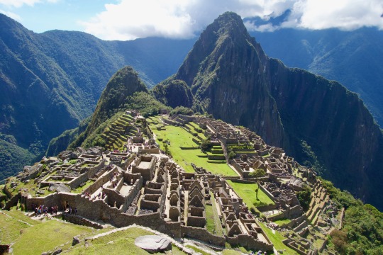
Exploring the Salkantay Trek with the Ultimate Map Guide
The Salkantay Trek is an extraordinary adventure that takes hikers through towering mountain passes, lush valleys, and remote villages before reaching the mystical Machu Picchu. To navigate this trail successfully, trekkers must familiarize themselves with a Salkantay Trek map, which provides critical information about terrain, elevation, and waypoints.
The trek starts at Mollepata, where the first leg of the journey leads to Soraypampa, an important base camp at 3,900 meters (12,795 feet). The Salkantay Trek map marks this location as the last major stop before reaching the highest point of the trail—Salkantay Pass (4,630 meters / 15,190 feet). This section of the trek is physically demanding, requiring careful pacing and acclimatization, both of which can be planned using the map’s topographical details.
Once past the pass, the Salkantay Trek map illustrates the trail’s dramatic shift from arid highlands to humid cloud forests, leading to Chaullay and Santa Teresa, where trekkers can enjoy local hospitality and natural hot springs. The final stretch toward Aguas Calientes is also clearly marked, showing the different options available, including a scenic hike along the Hidroelectrica route.
By studying the Salkantay Trek map in advance, hikers can better prepare for the altitude, distance, and weather conditions, ensuring a smooth and unforgettable journey through one of Peru’s most iconic trekking routes.
0 notes
Text
4 unmissable places during your visit to Cusco
Cusco is the main tourist center of Peru and one of the main destinations in South America. The attractions begin in the city itself and extend along its valleys and snow-capped mountains. Machu Picchu is the most visited place. However, there are many other places to visit. Here is a list of 4 trendy places that you should not miss while visiting the sacred lands of the Incas.
1- The Mountain of 7 Colors
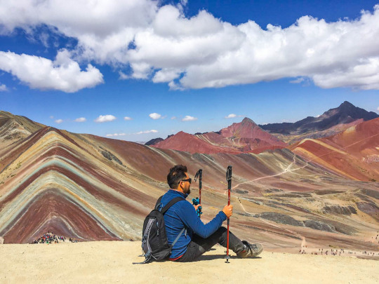
The fashionable tourist attraction in Cusco is called Vinicunca, Rainbow Mountain or simply Mountain of the 7 colors.
Vinicunca mountain is about 5,200 meters above sea level (17,060 ft). It is located at the foot of the snowy Ausangate, the highest in Cusco.
This mountain was discovered in recent years after the thaw that revealed the beauty of its multi-colored minerals.
The beautiful landscape offered by the mountain attracts hundreds of visitors every day. The place became one of the most photographed tourist attractions.
The tour includes transportation, lunch, tour guide and entrance. To reach the top, visitors must walk approximately 5 kilometers. The other option is to hire a horse from the local people.
Location - Community of Pampachiri, Canchis, Cusco. Price - The 1-day tours cost approximately $ 38.
2- Inca Trail
The Inca Trail is the most famous trekking to reach the ruins. The route passes through a small section of the gigantic network of trails that this ancient civilization built throughout its entire empire, which extended from Ecuador to Chile. It is estimated that the trail had an extension of 30,000 kilometers.
If you are interested in this option, you should know that it has a variable duration depending on the starting point of the tour. It can last 1, 3 or 4 nights, so you can adapt the trek to your time and physical preparation. The itinerary always ends in Machu Picchu, regardless of the days you take.
It must be taken into account that, for reasons of preservation of the natural and archaeological spaces that are crossed during the route, there is a limited capacity of 500 people / day that can start the Inca Trail, in groups of a maximum of 16 people. As a control measure, you have to pay a government permit of about US $ 150 that includes the entrance to the ruins. In February, the road remains closed for maintenance. If you want more information, go to our section of tours of the Inca Trail.
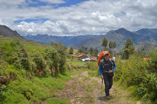
3- Salkantay Trekking
It is a good alternative option to the Inca Trail, whose strength is the variety of climates and ecosystems that can be admired. You will be surprised to be in a lush jungle and, just an hour later, in front of an impressive glacier in the middle of the mountain range. A real adventure, in scenarios that take your breath away. Another advantage of Salkantay is that the places are not so limited and you save the payment of the permit.
Find out and book the 5 day Salkantay trek here.
4- Trekking Choquequirao
If you love mountaineering and have time to dedicate many days to your visit to Machu Picchu, this is your trek. It includes long walks daily, along paths with landscapes that we guarantee you will never forget, reaching an altitude of 4,670 meters. On this route you can admire the two most important Inca ruins in the area. You probably haven't heard of the Choquequirao citadel. Nicknamed the "sacred sister of Machu Picchu" for their architectural similarities, these impressive ruins of almost 2,000 hectares are an extraordinary example of Inca construction mastery.
You will need 8 days and seven nights to complete this difficult and wonderful route. Find out in depth about the Choquequirao trek to Machu Picchu here.
#rainbowmountain#machupicchu#trek choquequirao salkantay#salkantay trek map#salkantay trek#choquequirao trek#inca trail
3 notes
·
View notes
Text
Salkantay Trek
Country: Peru Region: Vilcabamba Range of the Andes Starting point. Road to Soraypampa Type of hike: Lodge-to-lodge Duration: 6 days Distance: 40 miles (ca. 60 km) Highest Point: 4,630 m (15,200 ft), Salkantay Pass Elevation difference: Overall ca. 2,500 m elevation gain, with much larger drops End point: Machu Picchu
Day 1: This delightful multi-day trek started out at an unmarked location along the dirt road between Mollepata, a small mountain town situated high above the Rio Berbejo Valley, and Soraypampa. The road to get there was an experience in itself, definitely one of the bumpiest mountain roads I have ever been on. Our mini bus swayed crazily, and several times we had to back up because another vehicle coming from the opposite direction could not pass. So, it came as a relief when we were finally informed we could now disembark and start hiking. There was no sign or guidepost to indicate the presence of a hiking path anywhere, which made it rather convenient to have a guide. Indeed, although Peru is a hiker’s wonderland, featuring over 30,000 km of Inca trails--not even counting the numerous hiking paths that exist in addition to the Inca roads-- and yet there’s no system of guideposts signaling the directions, distances, or destinations of any given trail. It’s all about local knowledge here, and having a guide like we did made quite a bit of sense, unless one comes equipped with compass, maps, and navigational apps. Our guide, Pépé, not only showed us the way, he was also an inexhaustible and enthusiastic source of information, augmenting our experience with expert insights into the mysterious culture of the Incase and pointing out features of Peru’s flora and fauna, a subject about which he had an encyclopedic knowledge.
The start to our trek did not go as smoothly as we’d hoped, though. I noticed that Liang was not her usual vigorous self. Whether it was because of the altitude, the lunch, the bumpy ride (or a combination of those), she didn’t feel well, proceeding slowly and listlessly, until she had to step aside and bend over, being sick. After resting up a little and drinking some water, Liang gradually began to feel better, and soon she was smiling again. What a trooper!
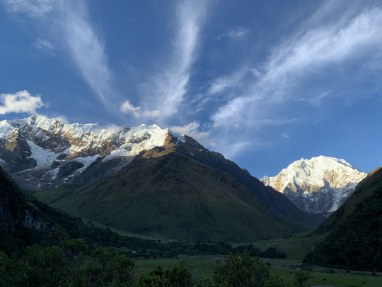
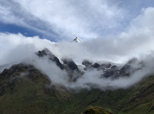
When we started our hike, the skies were overcast, but toward late afternoon, it began to clear up, and then minute by minute the awesome south facing side of Humantay moved more clearly into view. This beautiful mountain presents a long ridge with an almost vertical drop, ending in a neat summit pyramid, at an elevation of 5,473 meters.
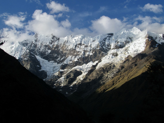
Despite the mountain’s attractive profile and highly convenient location (the road almost leads up to the foot of the mountain), amazingly this peak has only been climbed once: A team of young American mountaineers made the first successful ascent in 2017.
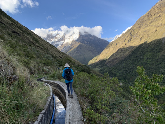
The trail leveled out after about an hour, and from then on it followed an ancient Inca irrigation channel. The channel had been reinforced by a European NGO and was now encased in concrete, with a blue PVC hose running along it. By now Liang had recovered her strength and vigor and managed not only to smile into the camera, but she balanced expertly along the narrow ledge beside the channel with a steep drop on the side.
As we approached the settlement of Soraypampa, the destination of our first day’s hike, the majestic Salkantay mountain (6,271 m.) came into view. It is a regular dome-shaped mountain with a little twisted knob at the top, the actual summit.
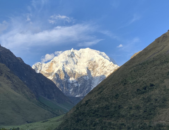
We approached our lodge just as the evening light was bathing the snowy peaks with fading light, producing a magnificent effect, which was further enhanced by feathery clouds streaking across the sky. We were lucky to have seen these mountains during a clear weather window during the rainy season.
Day 2: The previous day had been an easy, pleasant hike, and this day would be no different. Today’s plan was to hike up to Lake Humantay (4,200 m.), and then return to the lodge in time for lunch. The Mountain Lodge has an arrangement with the local landowner who lets guests from the lodge pass to the lake through his land.
Instead of following the well-trodden braided paths that were the chosen route of the day-visitors from Cusco, we approached the lake from a sideways direction, following the stream that ran down from the hanging glaciers of Humantay.
The morning was overcast, and we started under a fuzzy cloud cover, hoping for better weather as the morning progressed. As luck would have it, the clouds did begin to disperse during our climb, and after hiking for an hour and a half, we rounded a bend in the trail and there, below us was the glacial lake, its emerald green surface marbled by the swiftly passing clouds. The ever-changing spectacle was quite glorious.
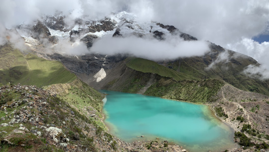
We held a leisurely picnic in front of this dramatic scenery, while the emergency horse was peacefully gracing a little ways off, happy that its services were not required. The term “emergency horse” may need a bit of an explanation: Given the high altitude we were on, the trekking operators had organized a horse and hustler to accompany us on all but the last day, ready to take on a hiker if he or she were to experience some health issues which, given, the high altitude was not unheard of. And even if all went well, the horse patiently carried our extra water supply, thus considerably lightening our daypacks.
We took a bunch of pictures at this beautiful spot, and then we started our descent to the lode.
The round-trip to Humantay Lake took only about 3 ½ hours in total; it was a nice warm-up hike a test our abilities for the long day hiking across Salkantay Pass tomorrow.
Lunch at the lodge was expertly prepared, meeting high culinary standards. This kind of lodge-to-lodge hiking in Peru was even beyond the kind of “glamping” we had experienced in Tanzania last summer. This here was simply and truly a luxury outing.
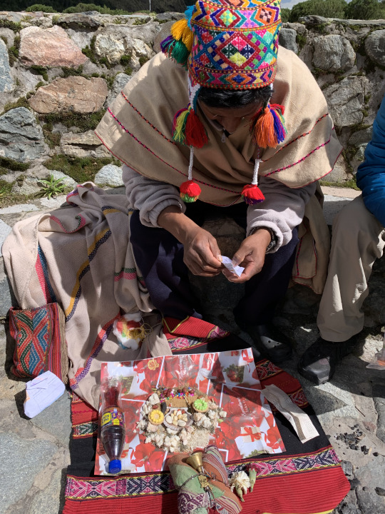
After a sumptuous 3-course lunch, accompanied by a glass of excellent Peruvian wheat beer, we gave thanks to the source of all this goodness by participating in a shaman ceremony with offerings to pacha mama (Mother Earth). We enjoyed this atmospheric ritual, punctuated by blessings spoken in Quechua, the original Inca language, while the shimmering summits of Humantay and Salkantay stood sentinel in the background.
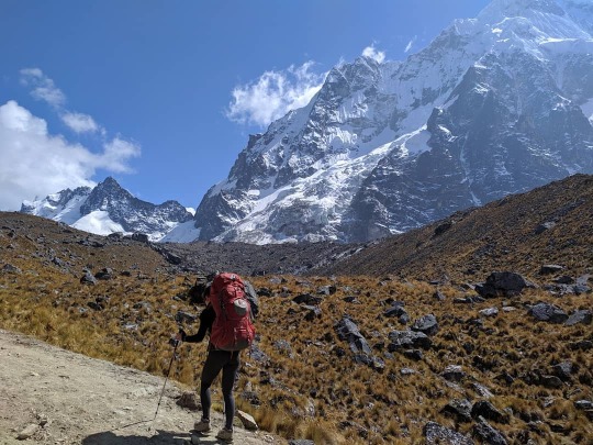
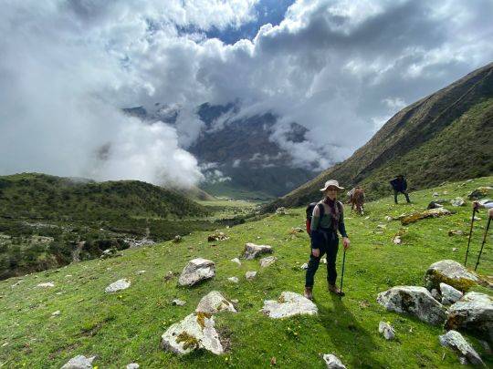
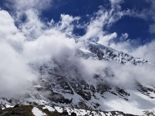
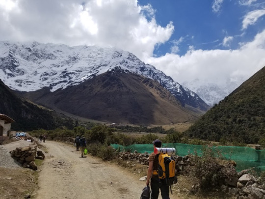
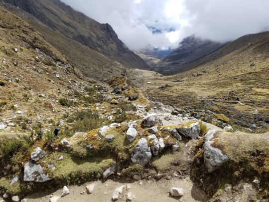
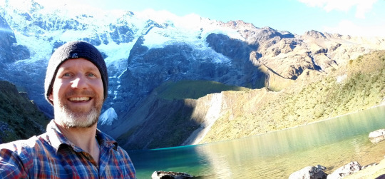
Day 3: Today was the most demanding hike, both in terms of length (ca. 10 miles) and elevation gain (800 meters up), topping out at Salkantay Pass (4,630 m). We started in hopes of favorable weather, spying the hulking shape of Salkantay partially veiled by clouds.
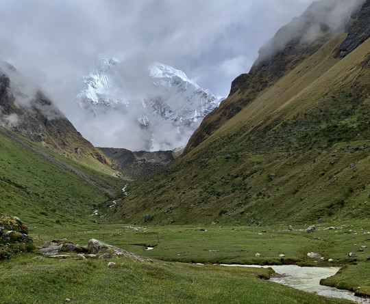
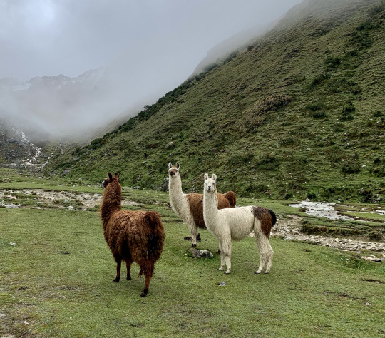
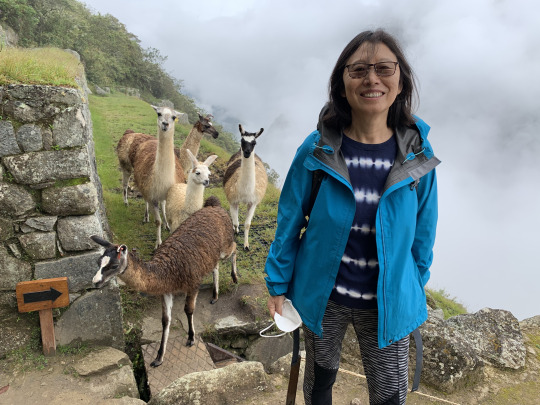
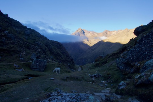
But the opposite of a gradual clearing up happened, as the clouds grew denser all the time. At least, we were spared direct rain, which was a big plus and not something to be taken for granted during the rainy season. Along the way to the pass, we encountered a group of llamas, and that was, for the time being, the highlight in terms of views.
Then, the path started to rise quite steeply, forcing us to rest at regular intervals, drinking copious amounts of water, which is the best precaution to keep altitude sickness away. We slogged on for a while in this fashion until about 11 am, when we had a more substantial break at a lovely meadow directly underneath the towering Mt. Salkantay, which briefly revealed itself.
After this break, we tackled the last stretch to the pass with renewed vigor, and here our various levels of adaptability to high altitude revealed themselves. While Lyra was forging ahead at a brisk tempo, Liang and I were following close behind; Arun’s heart, meanwhile, was racing at such a pitch, he was forced to adopt a slower pace. I’m fortunate to say that for me there are few joys as keen as high-altitude hiking—I love the feeling of giving it my all by huffing and puffing up the mountain, going hard to the limit, all in a gorgeous natural environment. Well, the gorgeous part was purely hypothetical for us in that situation, as we could see nothing but the nearest rocky slopes.
We reached the pass shortly after 12 pm and after taking a few pictures to document the accomplishment we continued down on the other side. It had been drafty and cold on the pass, and there was no reason for us to linger.
On the way down, we emerged underneath the cloud ceiling, and then we saw the devastation wreaked last year when a massive rockfall from the side of Salkantay crashed into a glacial lake below the mountain, displacing so much water that the resulting mudflow took everything in its path, from houses and trucks, to people and animals. Pepe told us that the the inn where hikers like us would stop for lunch before the catastrophe, was struck by the wave and destroyed, killing both the innkeeper and her daughter; and more lives were lost further along, as the huge wave rolled down the Salkantay river valley. We could see evidence of the destruction all around us: The mudflow had created a wide swath of rock-strewn wasteland where formerly there had been a fertile, grass-covered valley.
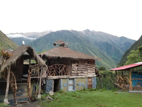
Wayra Lodge, where we were to spend the night, was spared the devastation because it sat atop a portion of the valley next to a deep ravine, and so the giant wave had passed beneath it. We got there at 2:30 pm, ahead of schedule, just as a vigorous shower was coming down--luckily the only time we were rained on during the entire trek! The cook had prepared a hearty soup and assorted vegetables, which we attacked with a wholesome appetite.
In the late afternoon, just as we were about to give up hope of seeing any scenery at all, the clouds slowly began to disperse, and then a truly picturesque landscape emerged around us. A short while ago, blinking into the fog, I had no idea where the snow mountains were located, whether they stood to the south, west, east, or north, so it came as a surprise when the towering pyramid of Humantay South began to peel itself out of the clouds right behind the lodge.
I watched the whole process of the gradual clearing, taking many pictures along the way. The contrasts and hues were such that the whole scene strongly resembled a romantic painting by Albert Bierstadt. The scene was affecting, sublime, and otherworldly, like a fairyland; with a bit of imagination, one might have thought it possible to see goblins hopping around or elves going about their business...
Day 4: Today’s hike followed the Salkantay River Valley down toward Santa Teresa, the community at the confluence of the Salkantay and Urubamba Rivers. It was a gradual downhill walk along a narrow dirt road that occasionally traversed a landslide. The main attraction of today’s walk was the stunning flora that transformed this region into one large botanical garden.
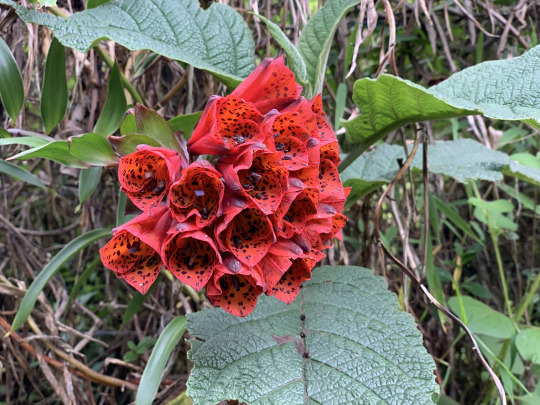
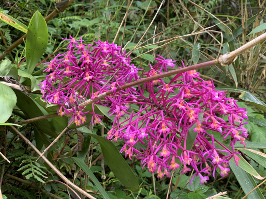
Pépé never grew tired pointing out the myriad wild orchids growing along the path, and he further showed us out wild tobacco, Azulina, Inca Flower, Pomeria, Bromelia, and many other species. At one point, we observed a Swordbilled Hummingbird, whose beak was longer that its entire body. It was quite a marvel to behold, and we wondered how the bird maneuvered with such an unwieldy appendage. At the confluence of the Salkantay and Urubamba Rivers, we descended steeply to the bottom of the ravine crossed over a narrow footbridge and then followed the private trail on the opposite bank that led to Colpa Lodge, at an elevation of 2,800. Upon arrival, the staff began to prepare a pachamanca, an earth pot meal in the style of a New Zealand hangi (or who knows: the hangi might be in the style of a Peruvian pachamanca).
The cooking technique is archaic: stones are heated over a fire, then a pit is lined with them, after which root vegetables and meats are placed in layers over the rocks, then the whole thing is covered with leaves and a layer of wet cloth, and on top of that a layer of soil is dumped. The only difference here was that the cooking time was merely half an hour, because only thin cuts of meat were cooked rather than a whole pig, as was the case when I attended a hangi in New Zealand.
Day 5: Today, we followed the Urubamba River further downstream in the direction of Machu Picchu. The dirt road was wider today, and we could march along it at a good clip, averaging 2-3 miles per hour. Right opposite us, across the gorge, we saw a trail as thin as a string, without any space for error, and yet a mule deer caravan was making its way around the bend where a stumble would mean certain death. We watched with bated breath as they turned the corner high above the river.

The destruction from the mudflow the previous year was still visible, with bridges washed away and multiple landslides a testimony of the catastrophe.
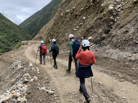
The landslides today were rather more unstable and prone to rockfalls than yesterday’s; as a measure of precaution, our guide therefore made us wear helmets to get across. Shortly before 1 pm we reached the end of our hike and boarded a minibus waiting for us. However, we soon regretted the transfer to the vehicle because we found ourselves on temporary mud road laid across a landslide high above the churning river, with hardly any room between our wheels and the sheer drop. with our vehicle tilting alarmingly toward the river, I felt a lump in the pit of my stomach.
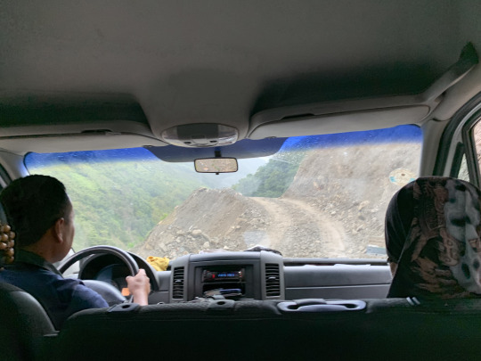
I glanced over at Lyra and saw that she was white knuckling her arm rest, a look of terror on her face. While Liang somehow managed to keep her cool, even though she was sitting on the side of the abyss, Lyra and I vowed to step out of the vehicle and walk, should another sketchy passage like this turn up. Well, we made it OK to to the end of the ride. And the remainder of todays hike was a pleasant walk along the old Inca steps toward Lucma Lodge, the last of our series of Mountain Lodges. This one was as well appointed as all the previous ones, featuring fine dining, hot-tub, beautiful rooms, and a comfortable common area.
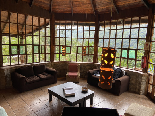
The whole lodge only has six rooms in total, and thus privacy and quiet comfort were guaranteed. That night, Jill and Julia, our fellow travelers who had so far done the hike on horseback but were now going to hike together with us for the rest of the way, joined us on the common table, and together we had a most animated and festive evening.
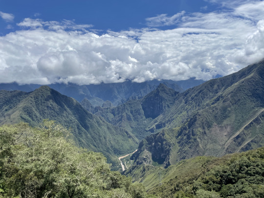
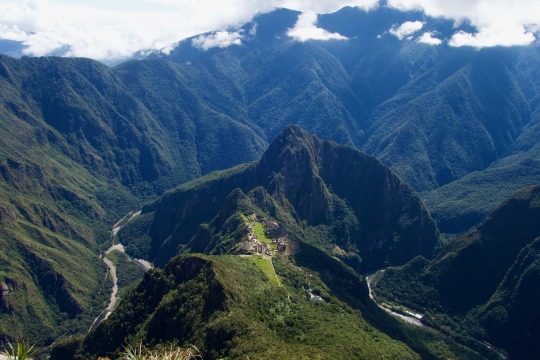
Day 6: Although we had covered pretty solid distances on each of the previous two days, averaging 8-10 miles a day, it was mostly downhill walking and were easy going. Therefore, we welcomed the greater challeng of day 6. It started with a steady climb of 600 meters from Lucma Lodge to Llactapata Pass. This trail justifies being called an Inca Trail, being part of the network of more than 30,000 km of ancient Inca roads laid down all across Peru. Quite amazing to think that half a millennium ago, Incas were plying these same paths. The weather was lovely, and we were enjoying ever expanding views as we gained altitude. After going uphill for about 1 ½ hours, we entered on a perfectly flat meadow and before us opened up a huge panorama of lush green mountains that receded far into the distance where the horizon fused with a barrier of pure white clouds. Far below us, the brown Urubamba River snaked toward Machu Picchu.
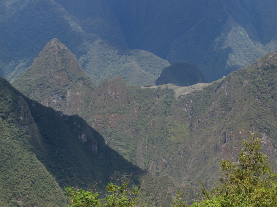
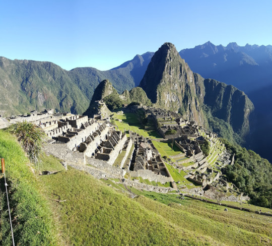
Upon looking closer, we did indeed see Machu Picchu in the distance. Both the ruins and the sugar loaf mountain, Huayna Picchu, which anhors the site, were visible.
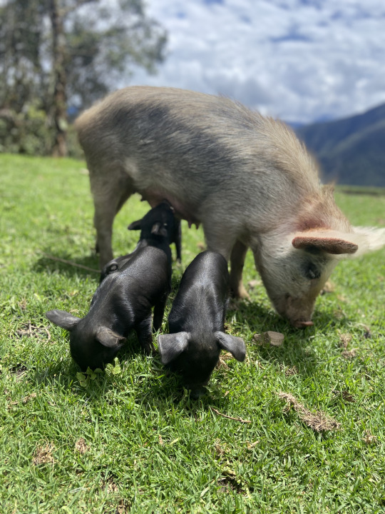
There was a ramshackle farm next to us and a mother with her two daughters were going about their business as if we were not there, which was quite a lovely surprise actually. A large sow came striding across the meadow in front of us, a litter of piglets hanging on to her, squealing and romping about.
The spot was lovely beyond description, and we wanted to linger for longer than the itinerary allowed and it took a good deal of coaxing from Pépé to get us to depart.
Half an hour later, we arrived at another gorgeous overlook where lunch was waiting for us. The whole party lined up on one side of the table as if we were reenacting the Last Supper by Leonardo da Vinci, but here we faced a pagan object of veneration: The archeological site of Machu Picchu, which was sitting on a saddle in the green mountainscape directly across the valley from us. It is hard to believe that the Spaniards passing by here would not have seen that shining city of a hill right across the valley, and so the theory that Machu Picchu was spared destruction by the Spaniards because they never discovered its existence is not very convincing.
After lunch, the harder part of the hike began--an endless seeming descent down to the bottom of the valley. As we followed the steep switchbacks, the temperature rose steadily, in direct proportion of our drop in altitude. Soon, I stripped down to shorts and a t-shirt. When we arrived at the banks of the Urubamba River in mid-afternoon, we felt for the first time truly like being in the tropics. Pépé directed us straight to the terminus of the train line running from Cusco to Hydroelectrica, the site of a small electrical power plant at the end of the trunk line. Cold beer never tastes better than after a long, hot, scenic hike, and we found this truism to be true once again, as we lounged for over an hour on the terrace of a restaurant next to the tracks where the train to Aguas Calientes was waiting.
The train station was eerily quiet, and most shops shuttered. Pépé told us that only about 25% of the usual number of tourists were here at this point. Indeed, the pandemic had taken a huge chunk out of the tourism business here which was frankly an advantage to us, since it meant no wait times, a quiet environment, and less overall hassle. But of course, for the local economy it meant a dire reduction of business.
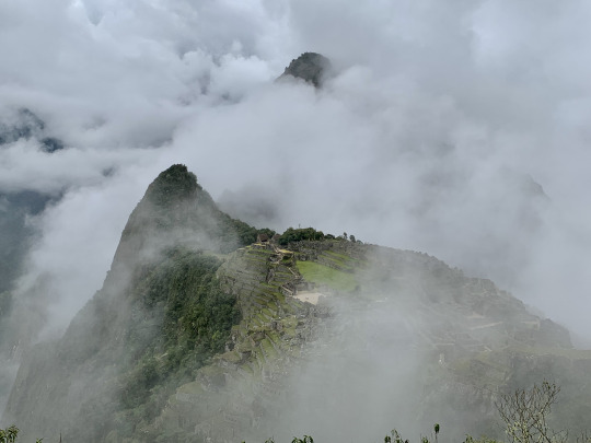
Day 7: In terms of weather, the visit to Machu Picchu started out like a reprise of our hike to Salkantay Pass: The higher we got, the foggier it turned out to be. On the plus side, we were the first people to cue up at entrance gate for the 8 am slot, something that would be unthinkable in prior years, when we’d be lining up among hundreds of people jostling for position. But today, only a handful of other tourists were waiting along with us. Nevertheless, the rules had not been relaxed one iota just because far fewer people were coming: One had to choose one of a number routes and then stick to it--no backtracking. Moreover, there were no bathrooms inside the site, and since one could not re-enter after exiting to use the facilities, this meant that one better not load up and guzzle coffee at breakfast.
Pépé chose a route that took us directly to the highest viewpoint. From this vantage, we should have been able to take in the iconic view over the terraces and many-tiered rows of ruins, with Huayna Picchu towering over the whole scene. But alas, we stared into grey fog instead. At least a few llamas grazing nearby gave us something to look at.
Luckily, after waiting for about 20 minutes, an opening in the fog appeared, and then--as if a curtain had been pulled aside--we suddenly spied the lay of the land and discerned the outlines of this magical site.
Soon, fog closed in again, leaving us hoping for further openings... In the meantime, Pépé was giving out a lot of fascinating information, so at least we were learning something. For instance, we now know how to distinguish the Empire style (square building stones) from the earlier Inca architectural style (multi-angled stones that fit together like a puzzle).
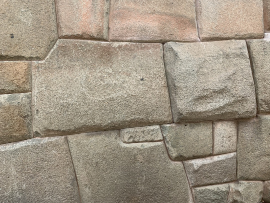
It remains a mystery how the Inca managed to hew the stone to such a degree of precision without metal tools, and how they transport these enormous weights, sometimes across large distances. The Inca style of building, with interlocking stones of various sizes, proved to be extraordinarily resistant to earthquakes. And so, while the social and military structure of the Incas was crumbling before the Spanish, due in large part to the catastrophic plagues that they imported, the architectural solidity of Inca buildings far outlasted that of the Spaniards. We further learned that Machu Picchu served as a fortress, an aristocratic mountain retreat, a ceremonial center, and a crop production facility, intended to be seen from far and wide and to strike awe into the beholders, especially those from societies the Incas were subduing. Why the Spaniards did not pillage and destroy this city is still an unanswered question. Perhaps they deemed the site too hard to conquer, assuming that there was only one entry gate which the Incas would have no problem defending. But even that explanation doesn’t quite convince, given the unquenchable greed and murderous missionary zeal of the Spaniards who were bent on destroying any evidence of Inca cultural sophistication that they could get their hands on. Anyway, it’s a gift to humanity that the Spaniards spared this place. Pépé had much to say, too, about the centrality of astronomy for the Incas, with several buildings and monoliths dedicated to the precise calculation of the calendar, which regulated a slew of social, ceremonial, and agricultural patterns.

After a while, the gaps in the fog became bigger, and finally the surrounding peaks and valleys revealed themselves, with mist clinging to the near vertical slopes at the far side of the Urubamba River valley.
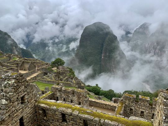
And so, what started out rather disappointingly turned into a truly remarkable visit. We could not have wished for anything better. By 11 am, we had finished our extensive tour of the site. Remarkably, we were quite alone for most of our sightseeing.
Only at the very end did we become incorporated into the larger wave of the crowd that had gradually caught up and then eventually washed over us.
3 notes
·
View notes
Text
Hiking the Salkantay Trail to Machu Picchu
The Salkantay Trail is a popular alternative to the Inca Trail to reach Machu Picchu. It is roughly a 37 mile long trail which takes about 4 days to arrive at the famous ruins. This trail takes you through the rugged beauty of Peru from the snow capped mountains down through the rainforest below. However, those who want to follow in the footsteps of this ancient path should read on to ensure you are prepared for the challenges and that you don’t miss out on some of the greatest experiences this hike has to offer.
Why choose the Salkantay?
For budget backpackers, there is no better option than the Salkantay to get to Machu Picchu. While the Inca trail is the most famous, it is restricted due to high demand. Not only do you need a permit, but it must be obtained several months in advance and having a guide is required. For the Salkantay, there are no permits required and no fees to use the trail. It is free to set up tents along the trail though if you wish, there are several houses along the way that will let you camp in their yards for a small fee. These places also offer food! You have much more freedom on the Salkantay to choose your own pace, stop at different spots along the way as you wish, and even take slightly different routes depending on your preferences. Perhaps the most important consideration for the Salkantay is that it is raw beauty like you haven’t seen before. You will be able to admire the marvel of the icy “Savage Mountain” and just a day later admire the wild flowers of the rainforest.

Recommended Equipment
You can check out our recommendations on how to pack for a mutli-day hike.
The Trail
The trail itself is well marked and easy to follow. There are a couple of points where you can choose different paths to go down, but either mapping your route beforehand or talking to other travelers should get you going in the right direction. This trail also has several small villages and houses along it, making it easy to make pit stops for food or to camp for the night. All of the locals that we met along the way were extremely friendly people and they made delicious food for cheap. There are also several streams and waterfalls along the trail where you can refill your water bottles. Just make sure you always fill up where the water is running and make sure you have some sort of water treatment system like Aquatabs or a LifeStraw.

Things to remember if you hurt yourself on the trail
A hike is not without risks or challenges, but they are no reason to be discouraged. Our group happened to run into a scenario where one of our members twisted an ankle halfway through the hike, effectively making us progress slower than expected. From the small village of Chaullay (below) we managed to secure travel for our friend to capac nan; a coffee farm and our next destination. Throughout this whole process we trusted the Peruvian locals with the responsibility of our friend and they were more than hospitable, even providing first aid and refreshments! So don’t be afraid to befriend some locals while you are here!
Spots of Interest
Humantay Lagoon
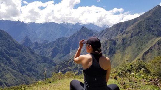
Toward the start of the trip, just above all of the camps lies an offshoot of the trail that leads to the Humantay Lagoon. This is a small lake fed by the mountain runoff and is a beautiful spot for pictures. However, the trail up to it is quite steep and is longer than it looks. For our crew, this small hike was the litmus test for who was going to be affected by the altitude, as this is above 11,000 ft elevation. More on dealing with elevation later on.
Coffee Farms
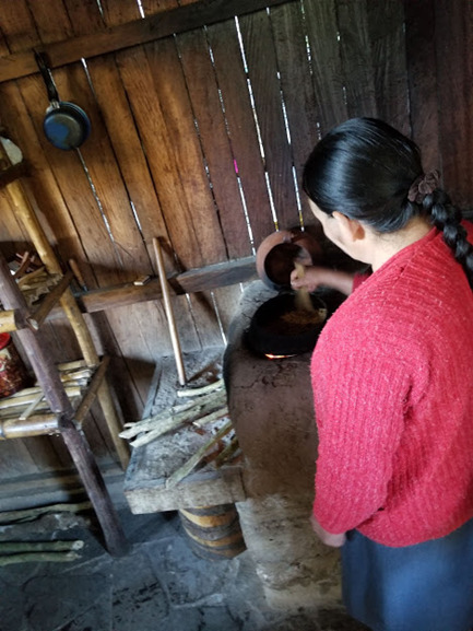
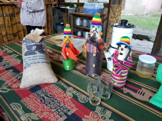
While hiking the Salkantay, we noticed that several of the locals had huge piles of white beans drying out on tarps beside the trail. It wasn’t until our last full day of hiking that we realized these were coffee beans as they are plentiful in the area. During one of our stops, the owner of the property where we set up our tents also worked on a coffee farm. He invited us to the farm when we got up the next morning, which was on our way up the trail. He showed us their entire process from harvesting the beans from the fruit to grinding the beans to brewing the coffee. We even scored some coffee liqueur at the end. This was a wonderful experience and also a small glimpse into the local lifestyle.
Hot Springs
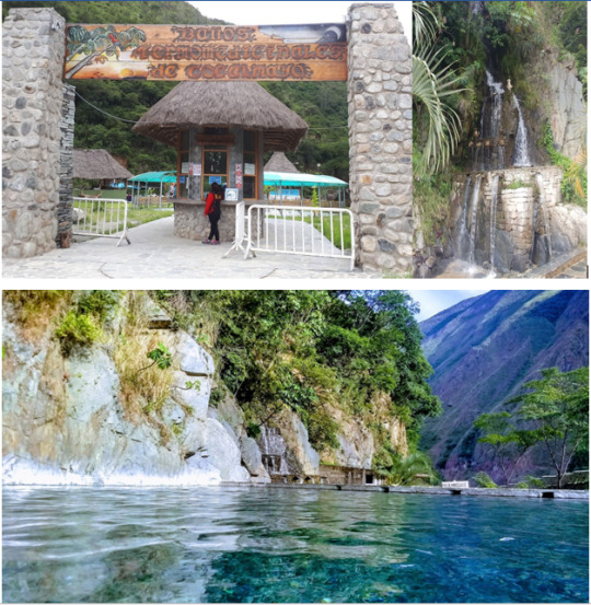
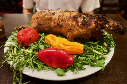
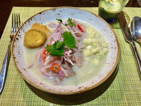
There had been a silver lining to our friend who was injured earlier in the hike. We had to split up the group which resulted in two entirely different experiences. The first group continued on to Llactapata, a steep mountain, and the second group took a ride to the Aguas Termales de Cocalmayo hot springs in Santa Teresa. You can make a guess as to which group had the injured person in it. The hot springs were unlike anything else we had experienced on the trip. There were natural flowing waters, canopy tops, paved floors, it's as if we arrived at a tropical hideaway. (Photos above courtesy of google as we were too relaxed to lift a finger.)
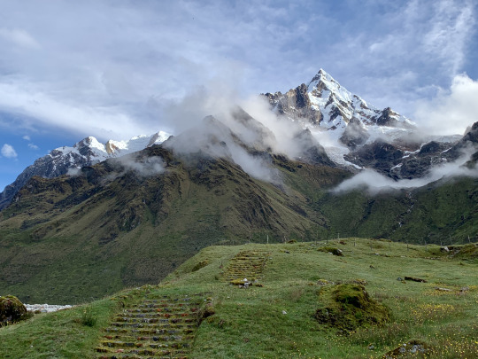
Llactapata
After a high energy morning hike which brought us up and over another mountain, we arrived at Llactapata. This place has one of the most breathtaking views in the world. Situated in a clearing on the side of a mountain, it gives you a vantage point to see both green and snow capped peaks from miles around, a waterfall below, and with a good eye and a clear day, you can spot the ruins of Machu Picchu in the distance for the first time. Pictures do not do it justice, but it was a great morale booster for our group and a wonderful spot to stop and rest in the middle of the day. Llactapata is also known for its own ruins which you can explore at your leisure or even camp at.
Things to Plan Head
As with any adventure, a little preparation will go a long way in making sure you have the best experience possible with minimal inconvenience. Here are a few things to do ahead of time so that your Salkantay hike is the best it can be.
Purchase Machu Picchu Tickets - You need to purchase tickets ahead of time in order to get access to the famous ruins of Machu Picchu. These can go fast so you will need to do this part several months beforehand. You can choose just exploring the ruins, the ruins and hiking Machu Picchu mountain, or the ruins and Hiking Huayana Picchu mountain (the one that is in all of the pictures). I found the cheapest way to get these tickets when booking as individuals and not a tour group, is directly from the government website. This website is quite dated and in Spanish, so we will soon be posting a step-by-step guide of how to book your tickets. Make sure you give yourself at least 5 days between arriving in Cusco and going up Machu Picchu. You do not want to miss your day at the ruins because you didn’t get through the trail quickly enough!
Route & amount of distance per day - Make sure to plan out your exact route along the Salkantay. This can be done along the way, but is much easier to do before you are on the trail without cell service. There are several maps that can be printed off (we don’t spend money on tourist maps!) and many of them have recommendations of stopping points for each day to keep you on track and make the most of your experience.
Your fitness - Hiking the Salkantay is not an easy feat. Our group consisted of experienced hikers and it was certainly challenging for each of us. You are hiking for roughly 9 hours a day several days in a row all while carrying a 30lb pack. This will test your body. Do practice hikes around your local area in the months leading up to the trip. Preferably with a pack to get used to the extra weight.
Get ready for the altitude - Altitude sickness sucks. In our group, half of us were affected by altitude sickness and half were not. It really varies and there is no way to guarantee that it will not affect you. In fact, with the highest point of the pass at 15,000 ft, it will likely affect you in some way. The best thing you can do is try to acclimatize slowly. Cusco sits just over 11,000 ft and is usually the starting point for people doing the Salkantay Trail. If you can, give yourself a few days in Cusco before you start hiking. It is a beautiful little city to explore and it will give you some time to get used to the thin air before you start doing strenuous activities. There are also medications that can be purchased or prescribed to help avert these affects. Finally, there is mate de coca, or coca tea, which is sold all around the area. For generations, the coca leaves have been used to ward off the effects of altitude sickness and they are still used today. I can personally vouch for this one, as I was hit hard by altitude sickness my first day on the trail. However, each morning I would have my coca tea, then would chew on the leaves as we started our hike for the day and it really did wonders for me.
Test your equipment - So you have made sure you have everything you need for this hike. But how do you know it will hold up during your adventure? You need to test your equipment before taking it on such a journey.
1. Tent - Take out your tent and make sure it is waterproof. We used a sealer for the seams of our tent as well as Kiwi’s waterproof spray for the tent overall. We then tested it using a water hose to simulate a steady rain and the inside stayed perfectly dry. Also, remember to have a tarp underneath your tent. Getting wet from underneath is just as bad!
2. Pack - You should also test out your hiking pack to not only make sure it has good comfort and utility, but most packs also have rain covers that should be tested beforehand. The same thing goes for rain jackets and water repellent hiking pants.
3. Boots - Your boots are probably your most important equipment. You need to make sure they are form fitting. Too small will give you excess blisters and pain, too large let your feet slide around and greatly increase your chance of twisting an ankle. You also need to make sure your boots are broken in. While buying brand new boots for a hike sounds exciting, it is a quick way to destroy your feet. You need boots that have already formed to your foot shape and that are still comfortable and reliable after several wears.
Main things to remember on the trail
Rise with the sun - get up as soon as there is some light so that you can break down camp and get ready to hike. This way you make sure you have the most amount of daylight possible for hiking. Believe me when I tell you that it is vastly more difficult to hike in the dark even with good headlamps. There is a higher likelihood of straying off trail and getting lost. Get up early and this won’t be a concern.
Slow and steady - Like the proverbial tortoise, slow and steady really does win this race. Since you started first thing in the morning, relax and don’t push yourself too hard. Remember, the purpose is to enjoy your hike and take in the beauty around you. Keep a nice, steady pace and the miles will melt away. Keeping this pace will also help protect you from injury. Every single injury I have seen during a hike has come from a fatigued hiker who was trying to push their bodies too much. Make sure to take breaks when needed and drink plenty of water.
Drinking water - For multiple day hikes like the Salkantay, you need water and lots of it. However water is heavy. You can’t carry all that you need with you, so you will need to fill up along the way. The most important things to remember are not to get your water from stagnant pools and to treat the water. The Salkantay has a lot of waterfalls and rivers so finding a source of running water will not be hard. You could also ask to get water from the locals, but there is no guarantee that is any safer than getting it from the streams.
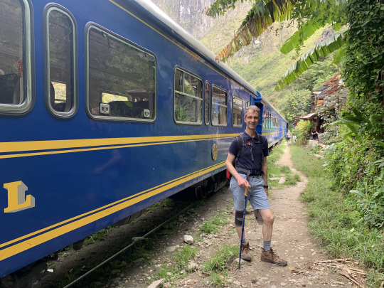
Hidroelectrica
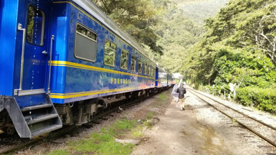
The hike through the Salkantay eventually brings you to Hidroelectrica. This is really a train stop turned small village. Here people can continue to make the trek to Aguas Calientes at the base of Machu Picchu, or they can opt to take the train the rest of the way. The train is pricey, however, and this is only a half day hike from Aguas Calientes. Besides, you want to be able to say you HIKED all the way to Machu Picchu! We decided to stop in Hidroelectrica for lunch, then trekked the rest of the way. We also knew we would only be at Augas Calientes/Machu Picchu for one day so we decided to leave our hiking packs with the owner of the restaurant where we had lunch and opted to take our day packs the rest of the way. The nice thing about the rest of the hike is that even though it’s about 12km it is almost completely FLAT. That combined with having almost no weight to carry meant a much faster hike.
Where to stay in Aguas Calientes
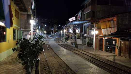
The town at the base of Machu Picchu is remote and picturesque. However, because this is such a highly trafficked tourist destination, the town has prices to match. As you hike into Aguas Calientes, you come in from the downhill side. The very first hotels you come across are large and ornate, rivaling the fancy hotels of large cities. Here is where you will see the older tourists. Here is where you will be received with a welcome in English. And here is where you will spend several hundreds of dollars per night. However, the farther up the hill you go, or if you go to the buildings behind the main street, the hotels and hostels get significantly cheaper. You may need to brush up on your Spanish a little, but we were able to negotiate a deal for our crew for less than 1 tenth the cost of the hotels at the bottom. Especially after 4 days of hiking and camping, a clean bed and a hot shower was more than enough for us!
When you are at Machu Picchu
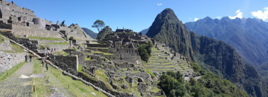
The entire trip has built to this moment. You climb the switchbacks to the top of the mountain and there you are...in front of the gates amidst a sea of people with no ruins in sight. There are 3 things that I recommend you do first
Go to the bathroom - This will be your last chance until you come out of the site and it’s actually quite difficult to get back in once you come out. Get it done now and then enjoy Machu Picchu for as long as you can.
Get a Spanish speaking tour guide - This is one area where we splurged. To get the knowledge of someone who truly knows the site was well worth it. We were able to learn a lot of the history of this famous site with our guide and once the tour was done, we still had time to explore for ourselves. She also helped us get through the gate quicker and showed us some of the best spots to take pictures. Also, if you get a Spanish speaking guide, it is cheaper than getting an English speaking guide. Our guide actually spoke both which worked out great for us because she gave us a tour in English but at the lower price!
Get in line - It takes a little while to get through the gates and into the site. Make sure you are ready so you can get right in and enjoy your time at Machu Picchu. Your guide can help expedite this process.
Once you are inside, get as many pictures as you want, explore the ruins, watch the llamas, and marvel at the architecture built into this mountain. One thing that I loved about Machu Picchu is that while it is quite touristic, each group has a set time slot. It gives you plenty of time to explore while also giving you enough space to truly enjoy it and to get beautiful pictures without people constantly blocking your way. On your way out of the site, remember to stop by the stand where they have the special Machu Picchu stamp for your passport! It is a wonderful memento to have.
1 note
·
View note
Text
Salkantay trek: the ideal trek to Machu Picchu?
PERU - The Salkantay trek is a 5 day trek to Machu Picchu tours . An unforgettable adventure. Reserve, price, difficulty, equipment: our advice for a successful hike. The Salkantay trek is the ideal trek to reach Machu Picchu. A magnificent itinerary of 5 days and more than 60 km, with or without a guide, from Cusco. What ends in apotheosis with the discovery of the most emblematic of the Inca cities.

Peruvians are formal: the more you walk to get to it, the more beautiful Machu Picchu is. Best. Because for us, it was obvious even before we started our world tour, six months before: Machu Picchu hike , we want to meet you on a walk! By force of calves, to "win" in some way, crawling for several days in the Andes.
The Salkantay is more accessible, in terms of reservation and price, than the Inca Trial. That's why we chose it!
2, 3, 4 OR 5 DAYS: WHAT TREK TO CHOOSE FOR MACHU PICCHU? Because, in addition to the Salkantay trek to Machu Picchu, there are several walks through Machu Picchu. The most famous of all is the inca trail tour or classic Inca Trail, 4 days and 3 nights. The only one that allows you to reach the site in the early hours of the last day through the Porte du Soleil, avoiding the entry of tourists and crowds of visitors. Very attractive, huh? Problems: The daily number of walkers is limited to 500 per day (guides and porters included), you must reserve several months in advance, which leaves little room for improvisation during a long distance trip. and spending money that has become fantastic (up to more than 400 euros per person).
Facing madness, Cusco agencies have invented an alternative and fun version, called the Inca Jungle Trek (4 days, 3 nights or, sometimes, 3 days, 2 nights), which includes various activities: mountain biking, rafting or zip line. You can find less than 200 euros. But not Sun Gate. Bof, not too much of our delirium.
Another classic: the Lares trek (4 days, 3 nights). It is quite interesting because it focuses on crossing Andean communities and meeting local people. It is quite easy, but suddenly less landscaped than the others. Again, from Cusco, after the negotiation, it is less than 200 euros.
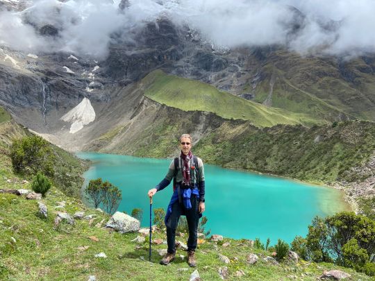
Finally, and this is the one we have chosen: the Salkantay trek. 5 days, 4 nights. Ranked among the 25 most beautiful walks in the world by National Geographic magazine, it is recognized for the variety of these landscapes. With an Andean pass of more than 4,600 m on the second day and a descent into the lush jungle the next day. Until the thermal baths of Santa Teresa, "only" at 1700 m above sea level (map above).
A magnificent alternative to reach Machu Picchu: that convinced us. Recognized as the most difficult (apart from Choquequirao trek, nine days of walking), it represents a good physical challenge. While still being accessible in its "with agency" and guide version, since it does not carry all its equipment: the tent, the mattress and the down are transported by truck or in the back of the mules. We are hot!
WALK TO MACHU PICCHU: OUR COUNCIL No, this hike is not easy. And the main difficulty, apart from the length and elevation, is the altitude. If you disembark in Cusco and jump straight into the hike, you run the risk of suffering. Try to start your stay in Peru with other less physical activities. Or as a minimum, plan to spend at least a few days in Cusco (3400 m) before leaving, to begin acclimatization; In addition, the city is very pleasant (see also our article Visit Cusco and the sacred valley). What to bring Provide snacks: dried fruit, cereal bars, etc. (There are convenience stores in the center of Cusco, or in the San Pedro market). Also a chocolate bar: it is good for morale or to celebrate your visit to the Col du Salkantay ... For your information, the meals were quite good, but not necessarily very generous, for people who walk all day. . You can leave a 10 kg bag per person on the mules (be careful, you will have everything on your back, except the down if you rented it, on the morning of the fourth day). Put on a pair of thongs for the afternoons, it feels good to be able to leave the pumps at night, your spare clothes, warm clothes for the evenings and nights. In your hiking backpack, lie down as much as possible, but bring a rain poncho and something to cover yourself well, it can get cold at altitude.
other alternatives in short you hce the tour 2 day inca trail with camping the tour you visit machu picchu with 1 guide, 2 personal of camping and 1 cook. and other tour is short inca trail is similar the other tour.
0 notes
Text
A Basic Guide to Peru and Colombia
Hola chicos y chicas,
A couple weeks ago (apologies for the delay-- I’ve been trying to get my life otherwise together since being back stateside) Joey and I got back from South America. It was my graduation gift to myself (congrats me) and I was lucky enough to have Joey to con into taking off work and going on another trip with me. We have since been dealing with mild to severe intestinal discomfort, likely due to the different bacteria in the water there. It’s been fun to say the least. But here I am, in my pajamas on a Tuesday (thanks unemployment). So, here is my basic rundown on all things Peruvian and Colombian.
Overall, Peru was very cool. I really loved the uniqueness of the culture and the people. The only caveat to this country (like any predominantly Catholic country) was that everything is closed on Sundays- everything. We started off our trip in Cusco (elev. 11,152′), planning to spend a couple days to acclimate to the altitude before our trek to Machu Picchu. Cusco is a pretty small city, nestled high up in a valley in the Andes mountains. It was once capital of the Incan Empire, and it is now a main tourism hub for the several surrounding Incan ruins. Cusco is a place you can go to see ancient Peru, and the survival of centuries-old traditions beyond the Spanish conquest of Latin America. We spent most of our time relaxing here, dealing with weird altitude medication side effects (including our hands and feet periodically falling asleep, dizziness, and occasional nausea) and trying to see the city. We happened to be there the month of Cusco’s anniversary, so every day there were parades, celebrations, and other festivals going on across the city. Standout memories: trying alpaca steak and cuy (guinea pig), making chocolate at the ChocoMuseo, making a dog friend who followed us around for almost a mile through winding streets, and meeting a baby alpaca named Robert.
Restaurants worth visiting: Pachapapa, Marcelo Batata, Carpe Diem
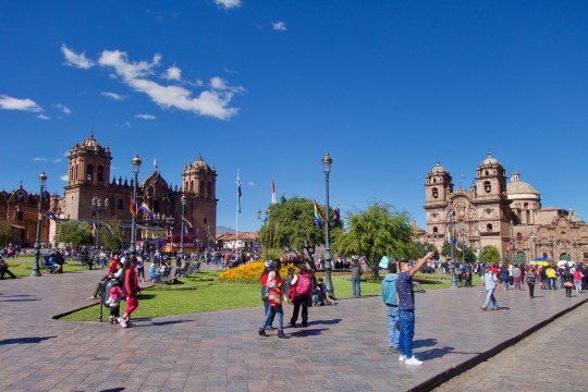
Plaza de Armas
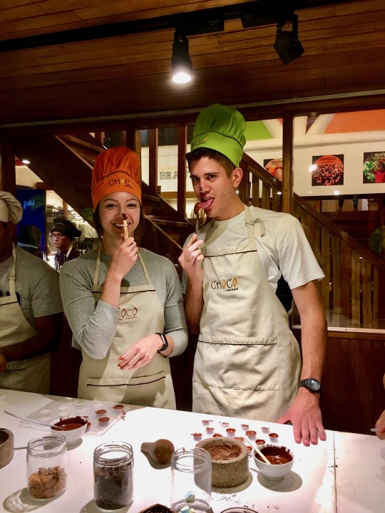
Making chocolate truffles
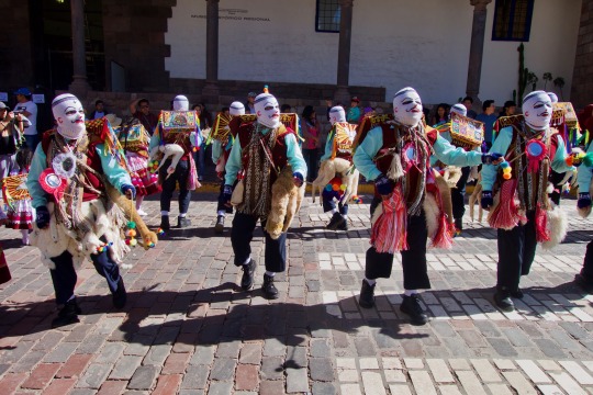
Parade dancers near the historic center
RIP little dude (since you’re probably curious, it tasted like dark meat chicken and had about enough meat on it to feed half of a small child)
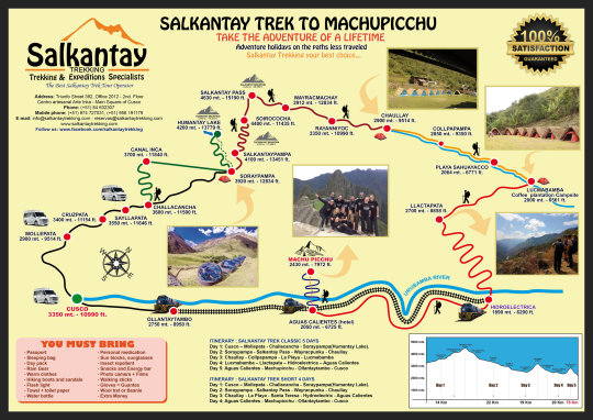
Here’s a map of our trek. We skipped some portions between Chaullay and Hidroelectrica, since we did the trek in 4 days and not 5.
The day of the trek dawned on us, and bright and by 4:30 am we were on the bus to Mollepata. This was the entry to the national park where Machu Picchu is located, where we grabbed breakfast at a local café and got back in the bus to Challacancha where we started our trek. After a short and steep incline, we made it to the Incan canal where it was a pretty flat walk to our campsite for the night. By the time we made it to our campsite, it was 1 pm and the chef was already preparing our lunch. This was our first experience with the trek’s meal situation, which we were blown away by-- we had a first course, and then multiple dishes to share (usually 4-5, which were rice/quinoa, a meat, vegetables, potatoes, and another mix of something previously listed). We rested for a bit after lunch, and had the option to hike up to Humantay Lake in the afternoon (a glacial lake about 1000 ft up from the campsite). We of course opted for this, not realizing the sheer difficulty of this additional adventure. This was our first real encounter with the lack of oxygen in the air- and although it was difficult, the hour and a half climb was well worth it.
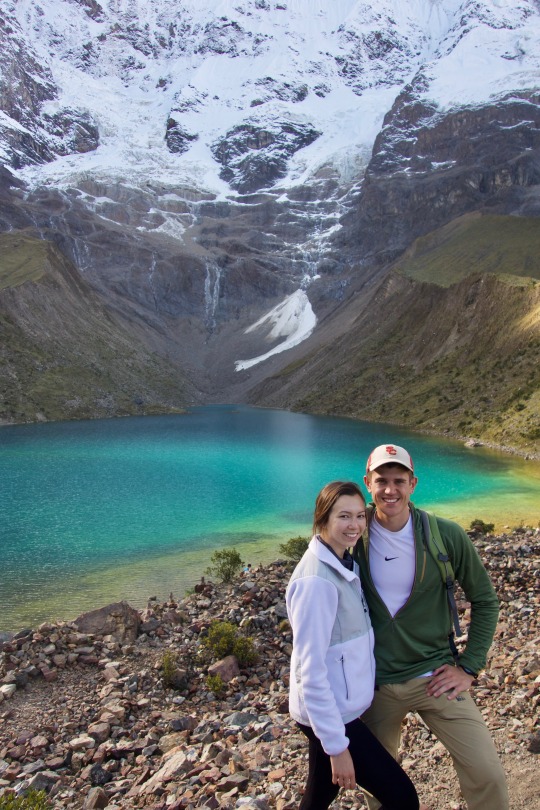
Humantay Lake a glacial lake that sits just underneath its namesake, Humantay Mountain
The climb down only took about half an hour, since we practically ran (the sun was setting and I was cold) and we spent the night in a glass igloo. I was really excited for this, since the stars were supposed to be beautiful to watch at night. Unfortunately, it was so cold outside (around 20-30 F with windchill) and with two humans inside, it turned into a humid/drippy 40 F greenhouse and we couldn’t see the sky through the thick layer of condensation on the glass. We had an early morning the next day (like the rest of the trek), getting woken up at 5 am with a cup of coca tea in our wet igloo. After a hearty breakfast, we started the most difficult day of our trek.
Kinda looks like LOTR right?

The squad in front of Salkantay Mountain
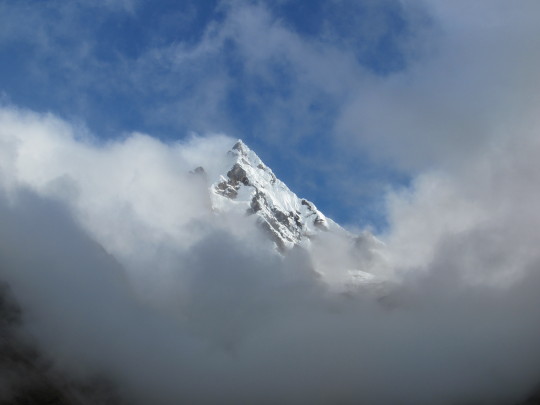
It took about 5 hours to climb up to Salkantay pass, which was a 2,000′ elevation gain. Our group ended up taking it at completely different paces, except I am proud to say that Joey and I made it up to the top first. Our highest altitude we reached was a little over 15,000′- and boy could I feel it. I was literally wheezing when I reached the top, but I was so relieved by the view it didn’t matter I couldn’t breathe. Staggering at over 20,000′ in front of us was the summit of Salkantay Mountain, with unobstructed views to the north and south. It was one of the most breathtaking (literally lol) moments I have ever experienced in my life.
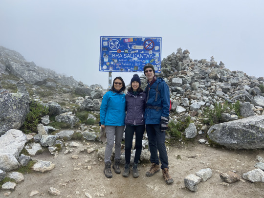
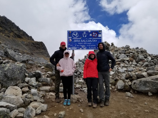
Joey and I at Abra Salkantay (elev. 15,190′)
The descent down was a long and treacherous one. Largely uneven rocky footing, our descent took close to another 5 hours through valleys and a high altitude rainforest. After everything, we hiked about 16 miles that day. I can’t even explain how much my legs/feet hurt afterwards.
The next day, we walked another 16 or so miles through low altitude rainforest, with rivers, fruit/coffee plantations, took a short bus ride in the middle of the day to speed up our progress, and then hiked all the way to Aguas Calientes where we spent the night in a hotel before Machu Picchu the next day. If you are going to Machu Picchu, you will likely stay the night in Aguas Calientes beforehand which explains why it is now relatively important. It has become a tourist hub for Machu Picchu, since it is a 20 minute walk from the gate at the entrance of the hiking trail/bus route up the hill where Machu Picchu is situated. We had the option of taking a bus up to the city, or hiking up steep stone stairs for about an hour and a half, and by this point we had no reason not to tolerate another painful climb up.
So, just past 4:30 am, we started up to our final destination: at this point, my body was hurting. My legs were torn up, my feet bruised and swollen from my boots, and my allergies were proving nearly impossible to deal with (I was blowing my nose about every 30 minutes, and at this point it was peeling and had third degree burns from lack of sunscreen). We climbed up in the dark, reaching the top just before sunrise.
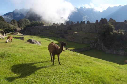
There were llamas grazing in an open grassy area in the middle of the city, which were apparently there just for tourists. They’re pretty vicious so don’t try to pull any snacks out near them- they’ll come right over to you and steal your food directly from your hands (I know this from experience)
We decided to do Montaña Machu Picchu as well, which if you’ve seen pictures of Machu Picchu is the ginormous mountain above the city. It’s about another 2,000′ up, and like the hike to Machu Picchu, it’s entirely stairs.
The ascent took us about another hour and a half, up the poorest excuse for stairs I had ever seen, but the view from the top was incredible.
Looking down from 10,111′. It was like having a bird’s nest view of the entire valley, since the summit could really only fit around 20-30 people crowded together at a time, and slope of the mountain is a nearly vertical drop downwards (the hike up is not for the faint of heart).
After taking as many pictures as we needed to around Machu Picchu, we decided to head back to Aguas Calientes for lunch. We took the bus down, which was probably the most well worth $12 I have ever spent. We hung out in Aguas Calientes for the rest of the afternoon, and then had to catch our 6 pm train back to Ollantaytambo where a bus was waiting for our trekking group. We got back to Cusco at about 10 pm, passed out, and geared up for our flight to Lima the next day.
The flight from Cusco to Lima is only about an hour, so we got into our Airbnb at a decent time. To my surprise, this was easily the nicest Airbnb I’ve ever stayed in. It was a beautiful seaside loft, newly furnished and overlooking the coast in Miraflores (aka the really nice neighborhood in Lima). Here’s a picture from the giant wall-to-wall window in our bedroom:
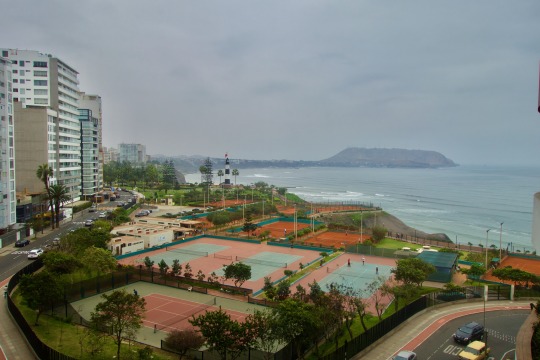
The pictures for this listing on Airbnb really DO NOT do this place justice.
Not having had lunch, and eager to explore our new city, we headed out for an early dinner in Miraflores. This is where I got to see Joey’s Español first in action- definitely useful, but nowhere near perfect. Luckily, it was just enough to get us to our dinner spot- La Mar Cevicheria. I got a maracuya sour (a delicious twist on the pisco sour, with passionfruit) and we both got catch of the day ceviche. It was perfect.
I think it was snapper? Not entirely sure though...
After dinner, we ran some errands in the area. By that point, I was half dead from my allergies, and after stopping at 3 different pharmacies in search of Benadryl (which they do not have in Peru) I ended up getting Zyrtec and Mucinex DM (except the Peruvian versions). We also went grocery shopping, and also to my surprise we found an organic grocery store that carried pressed juices, vegan/GF foods, and had a herbal apothecary inside (they even had my plant protein powder!!). I was in heaven. We then went back to crash for the night, looking to see more of the city the next day.
To sum up Lima, I’ll give you this: Miraflores/surrounding area (San Isidro, Barranco) is basically the only nice part in the city. The city center was filled with unbelievably beautiful architecture, but plagued with petty crime and dirty commercial areas that have taken over old historical buildings. It was sad. My main takeaways from this town were that: Miraflores is great and stay there, the food in Lima is incredible (and is mostly in Miraflores and surrounding area), and it has a very unique culture of diversity (lots of Asian influence). Standout memories: walking along the running/biking path on the coastline in Miraflores on a sunny afternoon, eating some of the best food in the world (casually), and getting stranded on the side of a dark freeway when every restaurant was closed (on a Sunday).
To elaborate on the food, we were able to get reservations at Central Restaurante- aka the 5th best restaurant in the world, and the overall best in South America. The owner, Virgilio Martinez, showcases Peru’s biodiversity in his dishes, available through a 17-dish tasting menu and an 11-dish menu, as well as through optional beverage pairings with native wines and infusions. The menu is set up that each dish comes from a different elevation/ecosystem in Peru, ranging from the ocean, to the Andes, to high/low jungles in the Amazon. Each dish was presented on a small handcrafted dish, decorated with different ingredients both edible and inedible.
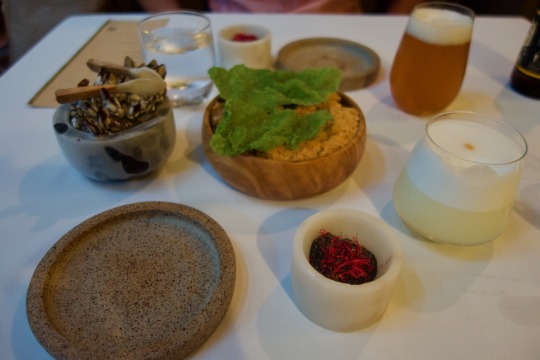
This was the first dish, called “rock molluscs.” It included a wafer made of sargassum algae, which was topped with a spread made of sea snail, mussel, and limpet. I also got a pisco sour and Joey got a craft Peruvian beer made with quinoa.
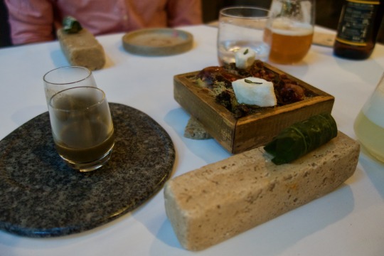
This was one of our favorite dishes. It was called “forest cotton,” beginning with the small wrap made of a plantain leaf filled with Amazonian fish and snail, followed by a bite of a cotton-like fruit called pacae, and finished with a shot of leche de tigre (the marinade used to make ceviche). This took our tastebuds on a TRIP.
That night, we tried Nikkei (a cuisine indigenous to Lima, which includes a mix of Japanese and Peruvian fusion) at Osaka restaurant. It was easily the best fusion sushi I’ve ever had- salmon sashimi with passionfruit sauce, seared scallops with truffle butter and lime, tuna with seared foie gras... *drools*
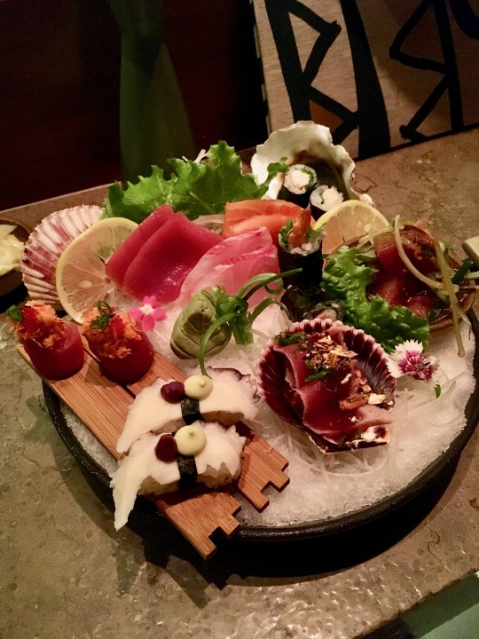
Here’s a plate of the chef’s choice for a tasting menu. Yuuuuuuum.
The next day, we headed to Cartagena. (Well, we had a layover in Bogotá first) It took us all day, but we got in that night and went to dinner at Carmen restaurant. It was a solid meal, (and air conditioned, thank God) and wandered around the city until it was time for bed.
Like all the cities we went to, we were in Cartagena for about 3 days. Cartagena might be my favorite city we went to. It’s on the Caribbean coast of Colombia, and there was definitely a strong Caribbean flavor to it. The food, the architecture, the people; I felt like I was in another country frankly. I loved walking through the streets, smelling the fruit vendors on every corner, and eating fresh seafood for basically every meal. I also liked finally feeling warm (every place we had been to was between cold-freezing) and getting a little color on my skin. I also got the chance to vape alcohol (!!!!) which was an interesting experience. We went to El Arsenal, a bar in Getsemani that was featured on the Travel Channel show “Booze Traveler.” The owner was super friendly and taught us about some of the history of rum, and let us sample a rum that was supposedly made underground in gourds by indigenous people (it was really good too). The process included pouring a shot of rum into a thick glass bottle, pumping air into it, and releasing the pressure that allows the alcohol to vaporize. As soon as the pump is pulled off the neck of the bottle, this weird science happens and you stick your straw in to inhale the vapor. Because it bypasses your digestive system, it doesn’t give you a hangover but is absorbed into your blood stream through your lungs and basically goes straight to your head. It was only a shot, but I was a little giggly for 15 minutes until it wore off. Overall, Cartagena was beautiful. I would love to go back and vacation there someday.
Restaurants worth visiting: La Cevicheria, La Mulata, Beiyu café, Café del Mural
Off the coast of Cartagena are a group of islands that people can travel to by boat for a day. The best way to do this would be to rent a private yacht and chef with a group of friends and do a “booze cruise” per say for the day. Since Joey and I couldn’t afford a whole yacht, we went with a tour group to an island resort on Isla Grande. We spent the day unbothered on a relatively empty beach, floating around in crystal blue water. We also got to go snorkeling, which I love to do pretty much anywhere I can. Overall, 10/10 worth the boat ticket.
Before we knew it, our time in Cartagena was up, and I had to say goodbye to my Caribbean paradise. We then headed to our last leg of the trip- Bogotá.
Bogotá is just as insane as Narcos cracked it up to be (maybe minus most of the violence though). Bogotá is massive, and pretty unlike any city I had ever been to. We stayed in a nice area called Zona T, which was filled with a lot of nightlife, shopping and dining.
Bogotá is where we got to experience traditional Colombian cuisine, which I can describe in one word: cheese. Everything was cheese. They even sold cheese in the airport, in multiple kiosks! Arepas, empanadas, breads, desserts... you name it, it probably had cheese in it or was made almost entirely of cheese. I had no idea that Colombians loved cheese so damn much. Who knew? Not me. Otherwise, Colombian food was pretty decent. I really love arepas, and those are basically a staple you can find anywhere, so I was set. I was also able to find “health” food at Suna Restaurante, where I got me a bowl of grilled tofu, kale, cucumbers/carrots, and red pepper hummus and a matcha latte on the side (this was the most relieved I had ever felt after a meal). We also ate at Andrés Carne de Res, which was one of the most unique dining experiences I had ever had. First of all, you have to pay cover here. Secondly, as soon as you walk through the front door, a lady dressed in what I would describe as a Día de los Muertos costume greets you with a shot of tequila inside a lime rind. Then, it takes you about 5 minutes to attempt to follow the hostess and weave through the restaurant to be sat at a table- in other words, the restaurant is the size of a warehouse. There’s salsa music blasting, several dance floors located throughout the space, large monitors playing a livestream of the dance floors mounted around the restaurant, and literally what seemed like at least one hundred other patrons heavily intoxicated and dancing around the tables. The menu is like 30 pages long, and you can basically pick exactly what you want to eat since there’s a gillion different options. It’s a steak restaurant, so we both got steaks and shared a roasted plantain with guava jam. Pretty decent food, but I don’t think this is really a place you go for the food- it’s really for the atmosphere.
We did a lot of touristy things in Bogotá, including going to Monserrate (a mountain with a Catholic church on top), the fruit and flower market, the Gold Museum, and the Salt Cathedral out in Zipaquirá (a town about an hour north of Bogotá). The Salt Cathedral turned out to be a 7-hour trip and basically a nightmare, which really capped off our whole vacation nicely. There was terrible traffic going there, and after discovering we couldn’t get an Uber back to Bogotá that night, had to wander the dark streets of this nearly abandoned town to get on a bus that sat in even worse traffic going back south. Worth it? I don’t really know. But at least I got a cool picture.
Restaurants worth visiting: La Puerta Falsa, Suna, Osaka (yes, the same restaurant in Lima. We ate there twice. I need them to open up a location in the U.S.)
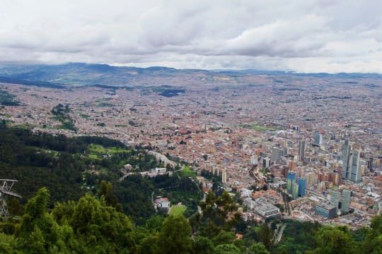
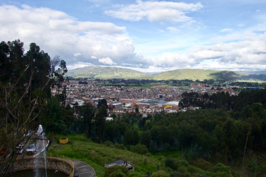
View of Bogotá from Monserrate (elev. 10,341′)
Capitolio Nacional (I fangirled seeing this because Narcos lol)
Paloquemao (fruit and flower market) I went ham on trying different tropical fruits, including lulo (a VERY sour passionfruit-like textured fruit), guanabana (I had tried the juice before but not the actual fruit by itself), mangosteen (10/10 delicious), and tree tomato (had tried it before, this one was not very good though :( ). I also got a mango and an avocado, because when in Rome Bogotá right?
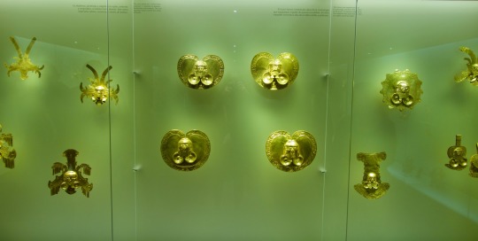
Museo de Oro. Did you know metallurgy was invented in South America?
Zipaquirá
El Catedral de Sal. This picture cost me 7 hours of my life. Starting out as a small shrine to the patron saint of miners, in the 50′s they decided to build a Catholic cathedral inside this salt mine that dates back to the 1800′s. The salt in this mountain has been a precious resource for the region and has been exploited by people for thousands of years, and it is even still being mined today.
All in all, this trip was totally unforgettable. I would 110% recommend anyone to go to either Colombia or Peru. Both are relatively cheap, safe, and easy enough to navigate with the help of international data and Uber. They’re also pretty close (if you count 7-10 hours of travel “close”). The people are friendly, the food is great, and I guarantee you’ll find something unexpected along the way.
NO idea when my next trip will happen, but stay tuned- I’m bound to end up somewhere soon.
Mucho amor por ustedes,
Miranda
1 note
·
View note
Photo
Salkantay Trek to Machu Picchu - Solo
May 2018
Total Miles: 66.5
Mollepata to Machu Picchu
Why am I hiking to Machu Picchu?
Since as long as I can remember, it has been a dream of mine to stand within the majestic beauty of Machu Picchu. Since the moment I saw it as a kid in National Geographic it sparked images of Indiana Jones and I knew THIS was a place I had to see one day. To add to the feeling of adventure, I wanted to hike the off the beaten Salkantay Trek vs the Inca Trail and I wanted to do it solo. Not knowing the language added to the adventure. Although this could be intimidating, the thought of being in a foreign land by myself truly lit me up!
Below are my daily journal entries on my 5 day, 4 night Salkantay Trek in May of 2018. I hiked it completely solo. I used the All Trails map and it was amazing. I have the pro version which allows you to download maps ahead of time. SUPER helpful as I hiked largely with my phone in airplane mode and the maps work great with GPS alone, no need for a cellular signal.
I hope my advneture inspires you to be bold and live life to the fullest!
Note: The All Trails maps were marked super well, excpet in two areas, which I note below.
Tip: Get your ticket to Machu PIcchu as far in advance as you can. I followed the steps on this site about three months before my trip. You can also purchase your additional hikes there to Wayna Picchu and Machu Picchu Mountain at the same time. WP was already sold out when I purchased my ticket.
Day 0: Flight to Cusco
I arrived at 4:30 PM and it was raining and hailing as I ran to the taxi. It stopped by the time I got to the hotel and never hailed again on the trip.
Tip: I’m vegetarian and was dying to eat at Green Point Restaurant in Cusco. I walked there from city center and the food was AMAZING. I highly recommend it for fresh, yummy Peruvian veggie food.
No one seemed to know how to get to Mollepata unlike what was described online. No worries though, taxi drivers will know how to take you to the collectivo that goes to Mollepata.
Day 1: Mollepata to Soraypampa (Mole yaah petta)
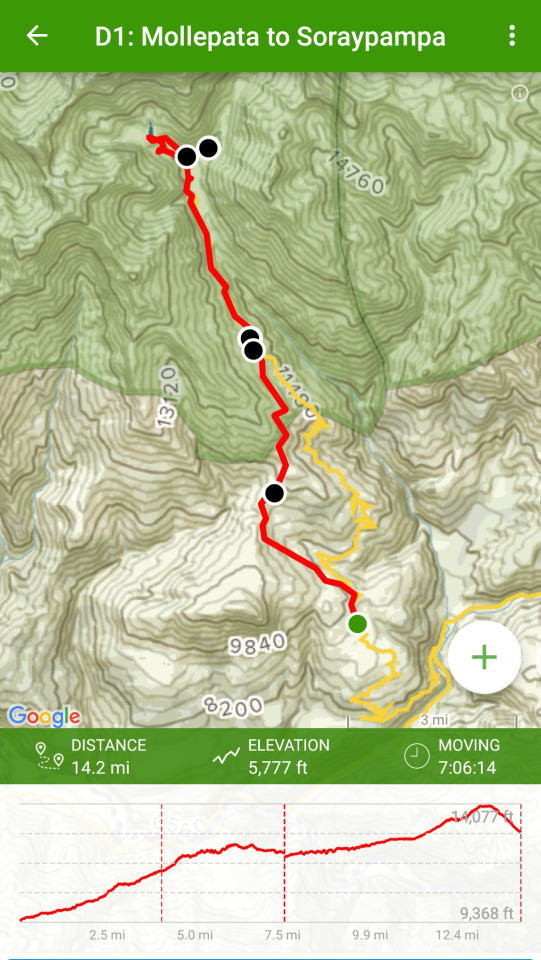
Map info from All Trails app
Note: I only had 12 hours to acclimatize before heading out on my trek. I know many people have issues with altitude sickness on this hike and it is advized to have 3 days in Cusco to acclimatize before heading out. I just didn’t have that time so I went for it. I got lucky as I was completely unaffected by altitude sickness. I did get medicine from my doctor ahead of time but didn’t wind up using it.
Cold shower, no warm water. Oatmeal in my hotel room made with my camp stove. Stored my small luggage at hotel despite not staying there upon my return. Not a problem. Yay.
Tip: be sure to get a luggage pickup ticket and put it somewhere in your pack that you’ll be able to find upon your return.
Yes, taxis are thriving at the crack of dawn. Taxi to the collectivo was 7 soles and 20 soles to Mollepata via the collectivo.
I arrived at the collectivo (van) at 4:40 AM and it filled up by 4:55 and we were off. I was the only gringo on the bus. Packed to the max, kids on laps. It felt like romancing the stone. :) The first hour of the drive was dark and foggy. After that the sun started to come out and the fog burned off and the views were absolutely breathtaking! Snow peaked mountains, lush green hills, waterfalls, cows; I saw one being milked in a field.
Altitude wise, I felt fine.
Two lane paved road most of the way until the Mollepata turn off. Then it's one lane with rock slides and carefully coordinated passing between the cars and trucks.
When I arrived in Mollepata I asked a local, "donde esta soraypampa?" - where is Soraypampa? That’s nearly the extent of my Spanish and I feel like I want to learn more, but it’s also nice to feel completely foreign. l was directed to go up to the top of the street where I saw a blue sign with a graphic of a hiker (below). Now, the journey begins.
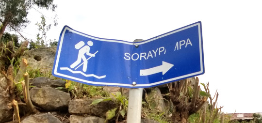
I went down the road for about 5 minutes and came to a split with a two blue signs indicating two ways to go (shown below); one with a bus and one with a hiker; take the one with the hiker (take the trail shown straight ahead below).
This sounds obvious, but the tours and groups take the bus route (the one on the right) so it feels like you’re going the wrong way... at first, but you’re not.
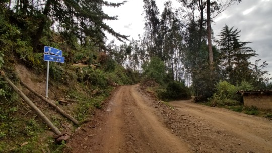
I walked on the hiker road for about 1 hour. The road has locals in cars going up, but eventually you come to the trailhead.
Being in a foreign country and hiking alone brought up many feelings of ambiguity in knowing where to go, but every so often I would see a blue sign which let me know I was on the right path. For those first several miles these signs were reassurance that I could DO this.
I ran into four people from Minnesota who were also doing the trek. We talked for a few minutes then I headed off on my own again. I never saw them again.
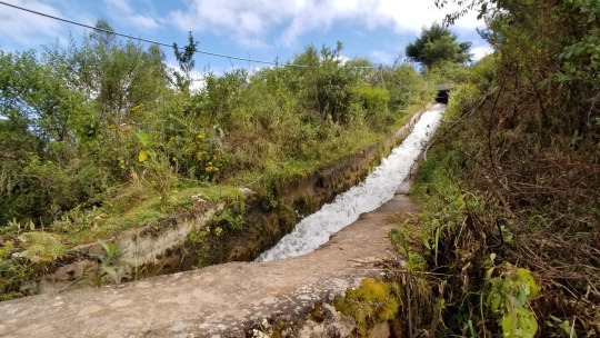
The trail itself is amazing there are rushing water canals that go along the trail in many parts (shown below). It's really cool to see that this is how the locals probably get their water to their farms and livestock.
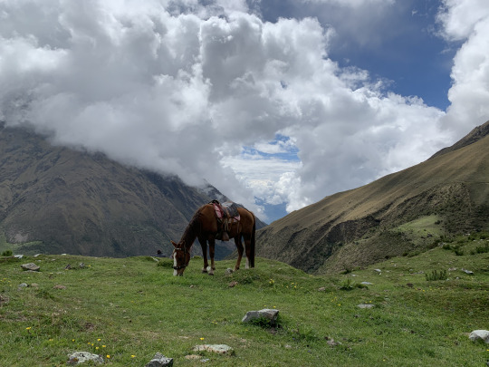
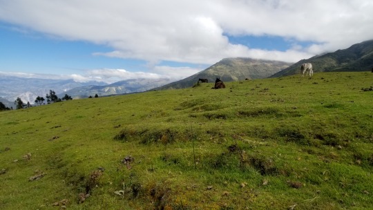
I stopped at Mirador (below) for break around 9:45 AM and the views all around are absolutely stunning. There were about a dozen horses in the field. I was all by myself. A great place to stop and rest. My pack weighed a ton so being able to take it off for a few minutes felt amazing. The bathroom was locked. I sunscreened up then headed off again.
The views over the next several miles were absolutely stunning and majestic and really took my breath away. I was so choked up that I honestly wept tears of awe several times this day. It really feels like I’m in one of nature's most incredible canvases.
At mile 7.5 the trail intersects with the road and the rest of the trail IS the road all the way to Soraypampa. Going this way vs the road from the start is a choice I would do again hands down. It’s SO beautiful, rural and alone; but that’s what I was here for; adventure. Going this way is no doubt more difficulta as as it goes up, up, up but the payoff is well worth it.
While here I took a break as there was a place to get water and I was in need of some energy. I used my filter and resupplied.
Once on the road, many trucks passed blowing up dust in my face. Overall it wasn't too bad but it did take away a little bit from the feeling I was feeling earlier in the day. I continued walking to Soray and got there at 2:20 PM I was happy with the time I made.
Immediately upon arrival I wound up heading right up the trail to Lake Humantay.
Note - Map issue: The trail that is shown on All Trails to the Lake made absolutely no sense and was incredibly difficult to hike; i.e. no visible trail and desnse with vegetation. See below for alt suggestion.
I had my full pack on as I had planned to camp at the lake; more on that in a bit. When I neared the top of the hill I wound up seeing a road a bit further out to my right that those who were camping in Soray we're using and it seemed like a much better way to go and I would highly recommend going that route.
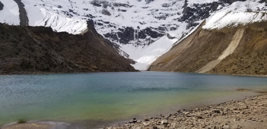
I arrived at the lake at 4 PM and it was all that I could have expected. As noted previously, I had planned to camp there so I had to lug my pack all the way up but upon arrival there's a giant sign that says that you cannot camp here. Also, it's right at the base of the mountains and the locals call this Glacier Lake. My thought was it was going to be super cold and it wouldn’t make good sense to camp here. So after enjoying the view and taking quite a few pictures I put my pack on and headed down the hill fast as it was getting late and I didn’t have a campsite yet.
When I got to the group basecamp I asked the locals where I could camp and, as far as I could understand, they said that I could not camp there and that it was for groups only. Perhaps I was wrong, as I don’t speak Spanish, but, in the end, I’m really glad I did not. At first I was quite bummed because I was already planning to camp up at the lake and had to come down another mile and a half to find out that I couldn't camp there either so I walked out of Soray towards Salkantay.
About a half mile down the trail I found a little stream with horses on one side. I tossed my pack over the stream and jumped across. From there I set up camp. I made my dinner and got settled in. This is where I’m writing this journal entry from now at 6:35 PM.
Being here is the most incredible thing I've ever done for myself. It’s an absolute dream looking around and seeing nature’s beauty at her full potential. The stars are so stunning, too. It’s a new moon so it’s total darkness with no light from the moon. WOW!
All fed and ready for bed. That was an incredible day one. I plan to wake at 5:15 AM. That's a giant amount of sleep but I think I need it because today was pretty crazy. Tomorrow is supposed to be the hardest day. Eeek. I can see Salkantay and it looks massive so I’m ready to get some rest and have a blast tomorrow!
Day 2: Soraypampa to Chauelly (chew ah lie)

Personal note: I didn't think today's hike was harder than yesterday.
Woke at 5:15 AM. Packed, made breakfast and left camp at 6:45 AM. The tour groups were leaving in droves, but the good news is they were going a different route. I stuck with the All Trails map and glad I did as I wanted to be a bit more on my own. Yay.
I hiked quite a bit just by myself before the trail finally intersected with the main group trail. It seems the tour companies have recently made a new trail and, at first, I started taking it. Apparently it's shorter and less strenuous. I checked my map and realized quickly that I was not on the right trail so I backtracked and went up the trail I had on my All Trails map. This part of the trail I went back to is called, The Trail of the Seven Snakes. I thought it was worth going back for. The groups did not go on this route.
The horses were heading up the Seven Snakes trail with their group’s packs, tents and food. They were already a fair bit ahead of me but at least I could see it was indeed the right trail. The trail up is a switchback and was, for me, the hardest part of the whole day. I welcomed it as I knew today was going to be challenging. The locals call the Seven Snakes trail, "the gringo killer." This trail goes way above the new trail and the views are stunning, plus a waterfall, yay! Then, all of a sudden, the trail pops down and intersects the new group trail.
I walked a bit until I reach a small village called, Suyroqocha. This is where the Salkantay pass begins. Woo hoo. The trek up to the pass is pretty intense. I had gotten some Coca leaves from one of the hikers to chew on. This was my first time chewing the coca leaves, it seemed to help give me a bit more energy or, at least, something to keep my mind off the strain of the pass.
The last stretch to the top of the pass is tough. I would take 4 - 5 steps and stop for a bit. Then 4 - 5 more steps then stopped again. It’s the highest point altitude wise and, at this point, I could feel myself higher in the atmosphere than I had ever been.
I reached the top of the pass at 10:20 AM (below). The pass is everything I hoped it would be and I had the most incredible weather and visibility.
I took a bunch of pictures, talked to a few of the other folks that were there and, after about 20 minutes, I headed out again.
Instead of heading down where the groups go down, I decided to trek to the Laguna, which was something I really wanted to see.
Tip: If you're facing the pass signs the trail to the Laguna is directly to the right and very clear to see.
The trail is pretty much straight and flat. Boy was I glad I went out to the lake. It was so incredibly beautiful (see below). There was no one there at all as the groups don't go here. I did not climb down to the lake as it was pretty long and steep. Not terribly bad, but the thought of trekking back up did not feel like it was going to be worth it, plus I had about 6 more hours of hiking to do today.
There’s a clear path back to the main trail that isn’t the same one I took out. At times the trail back to the main trail disappears, but I just looked ahead and found where it picked up and stayed on until it connected.
From there, the rest of the day was hiking with the groups, although I made a point to give room between me and the other hikers so I really feel I had a sense of being on my own, which I wanted.
I had a late lunch at 1:30 PM, resupplied my water from a steam then kept on.
Note: There are little huts where you can buy water, candy bars and such along the way. I never used them for water, but did pick up a bar at one point.
After the pass there’s a lot of downhill, only a small bit of uphill, but it's taxing on the legs. Trekking Poles helped a lot.
After a bit the trail turns tropical with lots of waterfalls and even some green canopies. There were some ruins at one point along the way, but I was worried I wouldn't get to Chauelly before sunset so I kept going. A local told me they weren't great, but I may never know. Boo. I’ve since kicked myself for not stopping to see them. On more recent hikes I now stop and check things out, even if it takes longer to do so.
Finally I arrived in Chaulley at 4:20 PM and I had to find a place to sleep, while walking through the town the map direction didn't seem to make sense so I followed the road a bit and even went through someone's property, with their permission. It was awesome to go this way as there was a fantastic waterfall right through their “backyard”. Wow!!
Right after that I met up with three folks doing the trek together. Sammy, Selayna and Will. Together we looked for a place to stay. After a bit of hunting we found a place where one of the trek groups stays called, Collpapampa El Mirador. They let us stay on a piece of land away from their group/guests.
I resupplied my water for the next day, made dinner then went to bed. I made my first “ramen bomb” and it was so terrible and starchy that I threw it out. Doh. Luckily I had a backup lentils and rice meal. Whew. Yay and yum.
I treated my blisters. I had a BIG giant one on my right big toe that I didn’t even feel before, wow.
Tip: I learned from yesterday how to be more efficient breaking down camp; i.e. leaving cook set out ready for breakfast, put bars and snacks for tomorrow in my pouches, etc.
Now I'm off to bed. Ear plugs tonight for sure. :)
Day 3: Chaulley to Llactapata Mirador
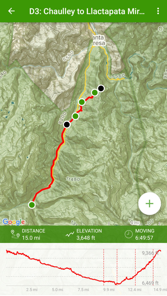
This is the jungle I’ve been waiting for!
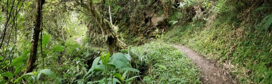
Perhaps the best day yet! Magic morning. I woke up before any sun was out and just saw silhouettes of the giant mountains right in front of me. The sound of the water below was soothing throughout the night. The roosters started crowing at 4 AM this morning, but, by that point, I had already had about nine hours of sleep so I was not bothered and went back to sleep until 5:10 AM.
I started hiking at 7 AM. I think if I would have started at 6:30 or 6:45 I probably wouldn't have seen a tourist or a group at all today, but right when I left there was a big group going out. Luckily they stopped so the guide could tell them some information about what they were looking at. This allowed me to get pretty far ahead before they started. I went to take the trail that is suggested by All Trails, but I was told that the first bit was washed out and to take the road. I was a bit bummed as I didn’t want to be on the road all day. As I walked along the road I could see what seemed in several spots that the trail I wanted to take had been completely washed away so, unfortunately, I had to take the road for about two miles.
I pretty much had the trail to myself, a few cars and small tour busses that passed every once in a while. It seems most people take a bus from Chaulley to their next destination. It never even crossed my mind. There’s just too much to see and I was here for the journey, not the destination.
About 2.5 miles into the day I came upon a small little hut that sold fresh fruit, which was really nice. I talk to a hiker who spoke Spanish and he asked the lady at the hut how to get to the trail on the other side. Apparently there's a bridge about 5 minutes down the road from the hut. I went and, oh my gosh this was the coolest thing I've ever done. Shortly after the hut there’s a waterfall that goes onto the road. I looked to the left, down the river and I could barely make out a small trail that was super steep with steps that lead down to a local made makeshift bridge and a rope pulley cart. These carts go across the river all over and apparently is how the locals transport their goods from one side of the river to the other. I got to the other side of the bridge (below) which wobbled a lot and had no handrail.
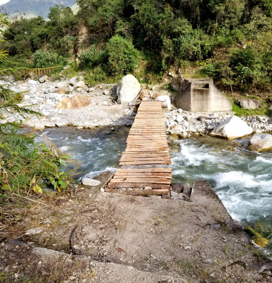
I was greeted by the man who lived here and I was able to communicate a little bit. I think 5 soles would have been nice to give him, but all I had at the moment was 50. He was kind enough to let me pass without paying a fee.
This part of the trail is glorious!
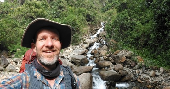
Tip: I am so glad I came this way as it's amazing. If you want a much simpler and faster hike, the road is the way to go but if you want to see the jungle, be greeted along the way with lots of interesting mariposas and the most incredible waterfalls, then go the trail.
I was alone the entire time on this trail all day! All the stops I took for brakes to enjoy the scenery to dip my toes in the water I was always by myself. It's pretty amazing as I didn't expect it it would be like that but I'm pleasantly surprised. Nothing better than to stop at one of the waterfalls and splash some water on my face!
This trip is, for me, one of the most, if not the most, amazing things that I have ever done for myself in my life!
I came to a little hut with fruits, water and snacks. I wound up getting a Twix bar, which I was going to cherish more than anything else on this planet at lunch.
After that there were several little huts like that along the way. I did see a cool looking swimming pool, and, when I got up to it there was a really posh bar kind of in the middle of nowhere. It was quite cool and empty except for the lady who worked there. I asked about the pool and she said it was a for Alpaca Adventures. That was a bummer cuz I already had made the decision to make the stop even if only for 10 to 15 minutes for a dip in the pool. Doh. No worries, I said, “Thanks,” and kept on going.
My legs are beyond sore today and every time I go downhill I feel one little pain after the next. But it's doable. No complaining here.
I just came around a bend and out in the distance I can see some mountains that look magical. Maybe this is where Machu Picchu is located? At least looking at them I can tell that I have to climb up one of them tonight and I am thinking that's going to be quite a challenge, but one that I'm ready to take on.
I am making a commitment to myself that even if I have to hike with my headlamp on I'm heading to the Llactapata tonight to wake to an incredible view of Machu Picchu.
La Playa is the next town I trekked through. It’s different than any place I had been in Peru so far. Definitely a Third world village, but I would not say it's terrible. I was expecting it as I had read many poor reviews online. Overall I felt it had a little charm to it. The people were very friendly and seemed quite happy.
I was able to get a cellular connection in La Playa just standing on the road. It's the first time I was able to send a text back to my family as I was in Cusco the last time they’d heard from me. I hope they got it as I just want to make sure they know in alright (they did). Where I exited out of La Playa it's where most people enter it. It definitely makes itself more presentable from the tourist entry direction.
I think I can see the Machu Picchu peak from here (later that evening I found out it was not). It's cool to actually be here in the presence of a site that I’ve seen for so many years and dreamed of one day seeing myself.
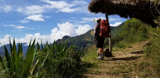
About half a mile down the road there’s a bridge with an awesome waterfall and I decided to stop there for lunch. It was noon and I was hungry and exhausted. The best thing was soaking my feet and enjoying the awesome view. It was nice to rest and take 30 minutes to do nothing. Heading out my feet are a little numb from the cold water but at least they're talking to me again.
Note: I'm a bit sick of all my meal bars. Note to self to have more variety for lunch meals. :)
Tip: Resupply water here as the resupply spots get a bit sparse between here and Llactapata and you’ll need it.
Right after I left I can upon a sign that said “Llactapata”. From here it’s a 3.5 hour hike up, up and up!!! I was so wiped out and just kept going. The views are stunning and I saw no one on the way up. After walking about two hours I passed a small hut where a nice man made fresh squeezed orange juice! No joke. I forget how much it was but it was well worth it.
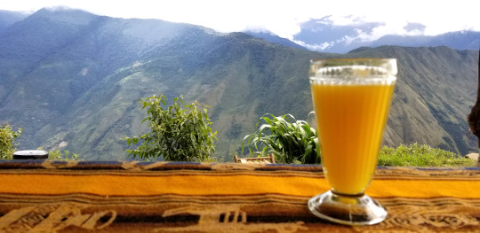
Tip: Get the orange juice!
I stopped here for a bit and took in the view. It’s magical and the man has some cool lounge chairs you can sit on too. It’s worth stopping here for a break as after this stop It's crazy uphill for the next hour.
At this point I was so tired I literally thought is going to pass out. Yikes. But, I just kept getting myself to take one more step over-and-over again. I was here for this, to push myself, to hike more than I had ever done at one time. There was no other way but to go forward.
On this part of the hike there were some tears of joy as I’m soaring up so high and it’s simply breathtaking!!!
Finally, after hours of going up, for what I thought would never end, I reached the top of the mountain. I had planned to stay at the Llactapata Lodge, as I had seen in many YouTube videos, but I was just so tired I had to stop, so I went out about 5 more minutes and camped at Llactapata Mirador. It was incredible! I was the only one here and NOW I could see Machu Picchu (below seen above the right side of my tent and the verticle tree) in the far off distance and she's stunning!
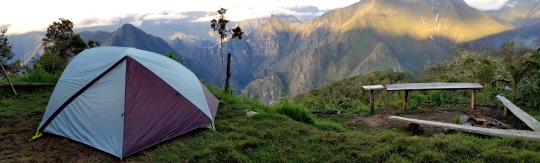
Right after I set up camp two hikers from France arrived, Max and Miriel. It was the first time I had seen hikers in quite a while. Right after that another showed up, David, who I met on yesterday's hike. David was solo too.
I took pictures, we all ate dinner together then headed to bed. We were all exhausted.
The frogs are singing happily. :) Good night.
Tip: Camp at Llactapata Mirador vs the Lodge. This spot is private and magical.
Day 4: Llactapata Mirador to Aguas Calientes
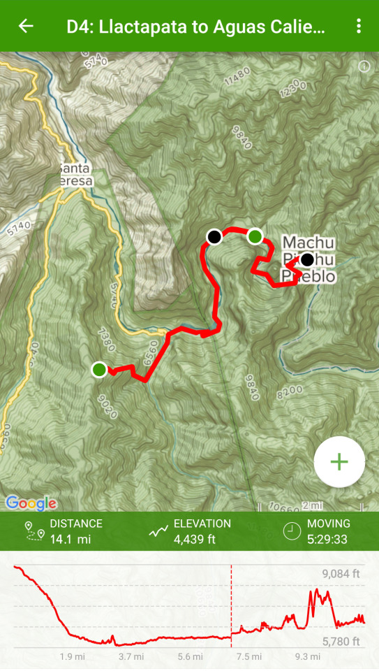
I woke up before the sunrise and took my time getting ready, watching the sun rise on Machu Picchu was surreal.
Going down the mountain was fun, fast and I jogged and slalomed down with my trekking poles. Not too far down I came upon some cool ruins. Apparently you can't camp there but it did look like a nice spot. It had a similar view to what I had the night before.
Right after the ruins I went through Llactapata lodge. This is where I was going to camp the night before as they have a camp restaurant. I'm glad I didn't stay here as there was a big tour group that was packing up and getting ready for the day. I stopped for a moment, took a picture of the view then kept on heading down the hill. After that I jammed down the hill with renewed energy. I was feeling great. All my pain was gone and I was fresh. I guess this is what they call getting your, “hiking legs.” This part down was super fun and mostly covered as a canopy of jungle. Some parts are open but mostly it's covered and shaded.
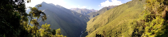
Once I got to the bottom I came to an amazing suspension bridge. As I went across it wobbled from side-to-side, just like I imagined in the movies. It was awesome. Once on the other side I came to a road and walked down a bit until I came upon a fish farm. The owner let me in and communicated with me via Spanish. From what I understood the different pools were for the smaller medium and large size fish. Thousands of fish swimming all together. It was a trip on the eyes.
From there I kept on and, out of the corner of my eye, I saw and giant waterfall. I couldn’t resist so I had to stop, take off my pack and hike over to the bottom of the waterfall. It was spectacular and well worth the stop.
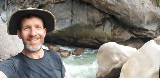
After that I kept heading down the road until I reached Hydro Electrica. Once here you have to check in, show your passport and sign in. After that I reached the famous railroad tracks that I’ll follow all the way into AC.
Tip: Do not forget your passport. You need to show it here.
All along the way there are lots of little stands. I bought a bag of Doritos. I never eat this type of food but David, from the previous night, had some at dinner and they were delicious.
Note - Map Issue: From here the All Trails map is not correct. The trail that it shows is overgrown and has barbed wire on it. It’s not hard to find the right way to go though, but the tracks do “Y” at a few points.
One thing I was really looking forward to was going through the train tunnel. I dunno why, I just thought it’d be great and I saw many pictures of people who had done it. However, it seems they don't allow people to go through the tunnel anymore. Either that, or the time I was going trains were coming through and perhaps they don’t allow it at THAT time? Nevertheless, I did try to go around the train to see if I could sneak through the tunnel, but there was a guy who stopped me and told me to go down via the main walking path. So it looks like the walking paths may now be the preferred method into AC.
Right after that David, from the night before, caught up with me and we walked down the train tracks together chatting on our way into AC. We stopped for some fresh squeezed juice. I had orange and he had pineapple. It was nice to chat with somebody and he's a cool guy too so it was a good conversation. We swapped hiking stories and gear choices, etc, for me that was pretty cool as I have never really talked to anybody about hiking stuff as this is a new hobby for me. Cool!
Note: One thing to note is that train track walk feels endless. It just keeps going and going and going, and it's very rocky so you have to look down a lot. It has tons of people going both ways so just know that you are not alone by any means when you're on this last stretch of the hike.
Just before I got into Aguas Calientes I stopped for a moment to check out of sight and David kept going. I didn't see him anymore on this trip. We exchanged emails and have been in touch since. Again, super cool guy.
Aguas Calientes is actually a pretty cool place. From what I've read everyone says it's a dive. I don't really think so. If feels a little like Sayulita, Mexico, if you take away the beach and put it in the middle of the jungle. It's got a good vibe and a lot of energy for sure.
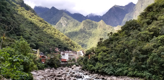
I got to my hotel, Gringo's bills, and it’s pretty amazing. I asked where I needed to pick up my MP ticket and they said I could do it there. So I gave them my confirmation number from the ticket I purchased in advance and they printed out my entry ticket. I guess all the hotels are on the same system. This was super convenient.
Getting to my room I had to go up and up a bunch of stairs and pathways, which I was quite fine with me by this point and my room was excellent.
Once in my room, the first thing I did was call my wife. It was SO good to great her voice. After that I took a hot shower. It was other worldly to lay on a bed; I don't think I've ever appreciate laying on such a comfy surface in my whole life!
Next I headed to the plaza for a late lunch. I had a burrito with guacamole and chips which was REALLY good.
After lunch I walked through the town and explored every corner I possibly could.
One thing that feels a bit strange is the shell shock. After having hiked for 4 days pretty much on my own, being self-sufficient, I've arrived at what feels like Disneyland. The contrast is a bit shocking. I can't say it's unexpected but it is interesting to know that many people simply ride in by train or bus versus hiking in. Neither is better. It's just the contrast of being a simple human being for 4 days and now being thrust back into modern life with stores, internet, cell phones, etc. I turned my phone off and took in the sights as I wasn’t quite ready to be in the modern world just yet.
Next I headed to the train station to make sure I understood how it worked as I was going to be taking it out tomorrow evening.
I then walked all the way to the end of town to a hot springs! Okay, now I have arrived! For 20 soles I was in it was AMAZING, relaxing and just want my body needed.
After that I headed back to the room and talked with my daughter for a bit; she was now awake. Oh man, I missed hearing her voice.
Now I'm having dinner in a little restaurant on a side street. The town is maze-like with steep, winding streets. I tried to get lost, but really can't cuz it's pretty small overall. Ha ha.
Day 5: AC to Machu Picchu!
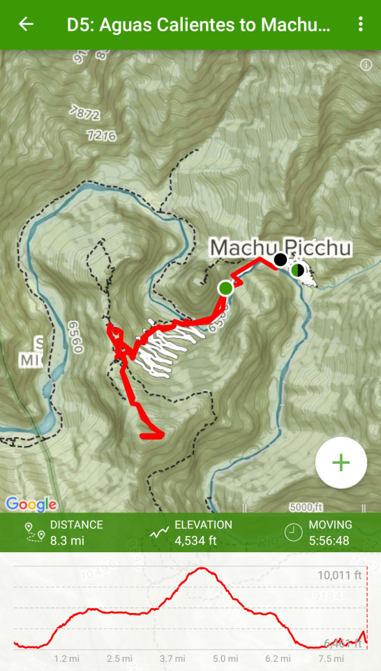
The big day has finally arrived, and it did not disappoint. Up at 4:20 AM.
Today I’m using a simple day pack that I picked up in town for 20 Soles. It’s still dark out so I’m using my phone as a torch.
There’s a line through the center plaza to get the bus but it was already wrapped around the corner and well up the street. People must have slept out here.
Going up the stairs all the way to the entrance was fun. There were many other people doing it and the energy was exciting.
Tip: Bring whatever water for the day you’ll need. There are no water sources once you start the trail up and no place to buy water when you get into MP. I was under prepared for this as there’s LOTS of climbing. A lot and more if you go to Machu Picchu mountain or Huayna (Wayna) Picchu. I wound up asking some people if they could spare some water and they were kind enough to help out.
My trip through the ancient city was incredible, personal and perfect. The weather was clear and I had the privledge of being one of the first in.
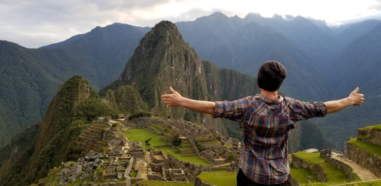
I can only imagine what it must have been like for Hiram Bingham to be here for the first time. A really fun experience to learn about his life and adventures while I was in AC too.
I hiked to the top of Machu Picchu Mountain. Wow, that was intense and super rewarding. The trail just keeps going up and up and it’s fairly exposed to the sun. A lot of people got heat stroke, needed to stop and went back down.
Tip: A hat and water are important on this day if you hike Machu Picchu Mountain or to Waynu Picchu.
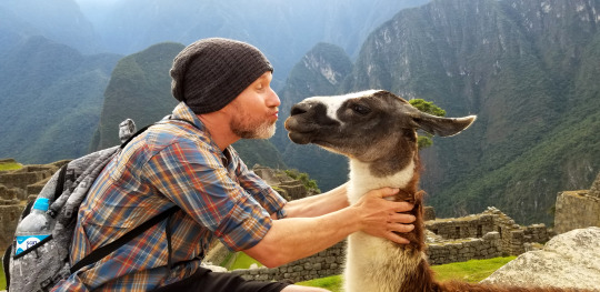
Tip: Don’t skimp on the train ride. I took the cheapest ride back. The train was super slow, I could have walked faster. No joke. It completely stopped several times for long periods and eventually broke down. We all hiked a bit until we could get to busses they had brought in to get everyone back to Cusco.
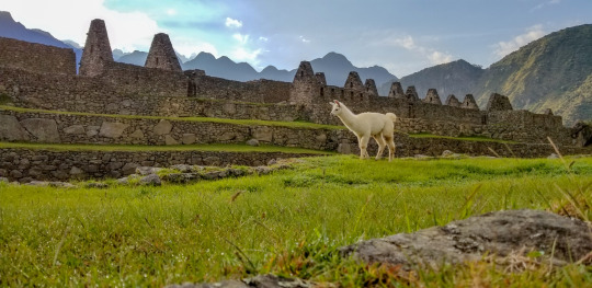
Although it sounds a bit nutty to have gone through a funky train ride experience, I really enjoyed the adventure of it all.
Once in Cusco, it was dark and late, I had to find a taxi and get to my new hotel. Luckily they were open late so I was able to check in no problem.
When I got back to Cusco I went back to Green Point Restaurant. They were just about to close (5 minutes) but they were cool enough to let me order take out. I ate in my hotel room then passed out for a full night of much needed slumber.
In Closing:
I had an incredible adventure. Beyond anything I could have ever imagined. The confidence I gained in my ability to travel to a foreign country alone and hike solo through rural, tropical and snowy terrain, living out of my pack and from the Earth was so satisfying.
On my flight back home I watched a documentary film called “Love Thy Nature” by, Julian walker. It struck a chord with me and resonated with the experience I had just had. Remembering that we’re simple human beings. It’s an amazing to have this feeling so clearly in view. I only hope I can hold onto this feeling and the clarity I feel I have in my life now.
0 notes
Text
Why Every Adventurer Needs a Salkantay Trek Map Before Hiking
The Salkantay Trek is a physically demanding yet rewarding journey through some of Peru’s most remote and stunning landscapes. Given the varied terrain and unpredictable weather, having a Salkantay Trek map is essential for navigating this challenging route.
The trek spans roughly 74 km (46 miles) and is typically completed in 4 to 5 days. The map outlines key altitude markers, with the highest being Salkantay Pass at 4,630 meters (15,190 feet). Understanding this altitude gain on the map helps trekkers pace themselves and prepare for potential symptoms of altitude sickness.
Beyond elevation data, the Salkantay Trek map also highlights important natural landmarks, such as Humantay Lake, which many hikers visit on their first day. The route also passes through Chaullay and Santa Teresa, both of which serve as resting points before reaching the final destination: Aguas Calientes, the gateway to Machu Picchu.
By carefully reviewing the Salkantay Trek map, trekkers can identify the best camping locations, water sources, and emergency exits along the trail. This knowledge ensures a safer, more enjoyable journey, allowing adventurers to fully immerse themselves in the breathtaking beauty of the Andean wilderness.
0 notes
Note
Are you doing a tour for Patagonia or Peru (machu picchu trek)? If so which one? Or what do you recommend? And are you booking ahead? :)
Ahaha no way, I've got a tent and I'll have my own cooktop and a map and I'll walk it by myself. I hate paying companies for treks it takes away all the adventure and it's such a waste of money!!! I'm not doing the inka trail either I'm doing the salkantay trek which you can do unguided !
1 note
·
View note
Text
Salkantay Trek without a guide: Day #1
Now that we are a little bit warmer (only a little bit) in La Paz, Bolivia and have somewhat of a decent WiFi connection, it is time to share our experience about doing the Salkantay Trek without a guide.
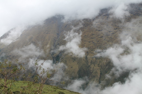
Before we set out on this excursion, as there is not a lot of information available about doing this trek on your own, we spent quite a bit of time checking blogs and talking to tour companies about the trek. We also spent $25 CAD and bought a GPS software for our phone (Gaia GPS) that has topographic maps, and allows you to plan routes…etc.
Starting the trek we quickly realized a couple things:
1.
All the tour companies advertise that they start in a town called Mollepata, however they don’t, they start 6 km past and 500 m higher in altitude than Mollepata at a place called Mocashqo.
2.
Anyone who has actually done the trek on their own and blogged about it, has done it in dry season. We, happened to be smack dab in the middle of wet season.
Here we go!

Day #1 We woke up at 4:00 in the morning, left our AirBnB and went to the street (Arcopata) where the collectivos leave to go to Mollepata. On our way we nimbly were dodging drunk Peruvians stumbling out of the clubs, and also dodging the puddles of piss on the ground on the bar street. We also managed to pick up a little female dog who was in heat and being chased by two males, we must have looked like salvation to her and she became our best friend for the next little bit. The collectivo (15 soles per person) to Mollepata starts loading at 5:00 AM so we were there right on time, but it doesn’t leave until there are 11 people. So! In this lies challenge #1 for our day – we didn’t actually leave Cusco until 6:30 AM and weren’t on our feet and walking until 9 AM, about an hour behind what we had hoped for.
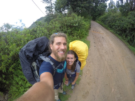
Challenge #2 didn’t show its face until we had already completed the first 6 km of our trek and gained 500 m in altitude going from Mollepata (2900 m) to Mocashqo (3400 m). We arrived at Mocashqo after being poured rain on and walking through mud and streams for the better part 2.5 hours, and were greeted with a sign outlining the rest of our journey in front of us. It was 11:30 and we were only at the point where the tour companies start their journey, and they advertise the first day as a moderately hard 5-7 hours. After already climbing 500 m in elevation with our 20 and 30 kg packs, 5-7 more hours of ‘moderately hard’ transformed into pretty miserable hiking for us.
For the next 6 km, we gained another exhausting 400 m in elevation as we began to make our way to a ridgeline. Challenge #3 (it was a constant throughout our entire journey) - At this point, the rain hadn’t let up and had only gotten stronger so any attempts we made at taking a break resulted in shivering and being even more soaked than we already were.
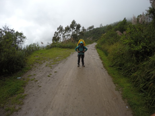
It was about 2:30 PM and we caught a really big break in our day. We ran into a local herding his donkeys, and we asked him how much farther to our final destination for the day (Sorraypampa), and he said 2.5 hours more, which was really disheartening, BUT he told us to head up this little path and then our route to Sorraypampa would be ‘mas plano’ (more flat) than if we were to take the road. This was a beautiful life-saver for us!
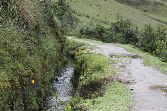
The road was pretty up and down the last 8 km to town, and the little ridge path we were on was a gradual slope up for the rest of the walk, not to mention it had some absolutely stunning views of the valley we were in. There were multiple ‘troll-bridges’ as Amber-Leigh so fondly calls them, and honestly neither of us have seen so many waterfalls in our lives.
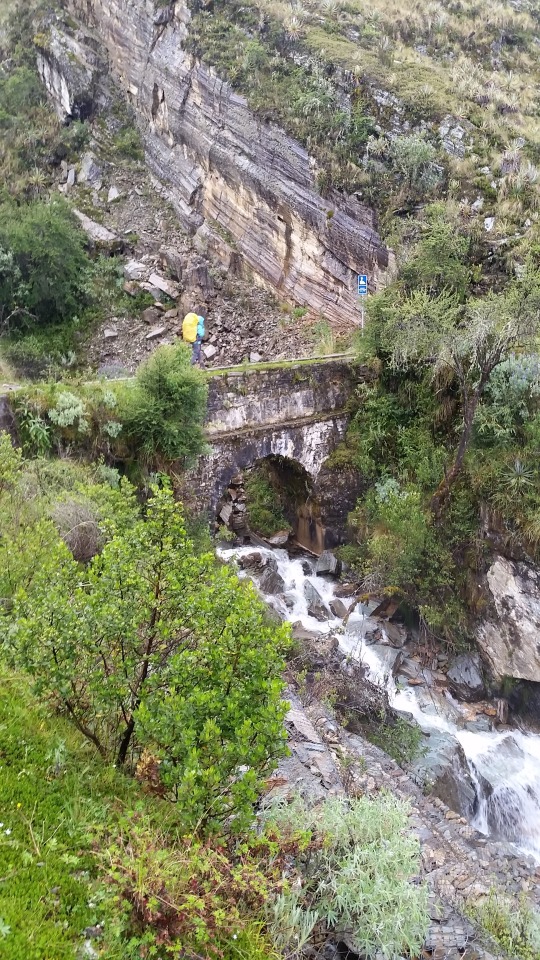
It was absolutely breathtaking, and was a shame that we were head down walking as hard as we possibly could to avoid being stranded in the valley at night. Coming down into Sorraypampa (3960 m) was also beautiful, not just in the scenery around but a beautiful sense of relief that we had made it. Although before we could get into Sorraypampa we had one last task to complete, and thank goodness for another local guy we met. During rainy season there is a raging river separating Sorraypampa from the trail, and you need to cross it somehow. Luckily there was a movable (though it weighed 200 pounds easily) bridge/ladder contraption that you could put into just the right place on the river and walk across. Thankfully, the local man showed us where to a) find the bridge, b) where to put the bridge, and finally c) actually helped Ian put the bridge in place. Turns out that if they put a more permanent bridge in place, it usually gets swept away, so the movable alternative is the best bet.
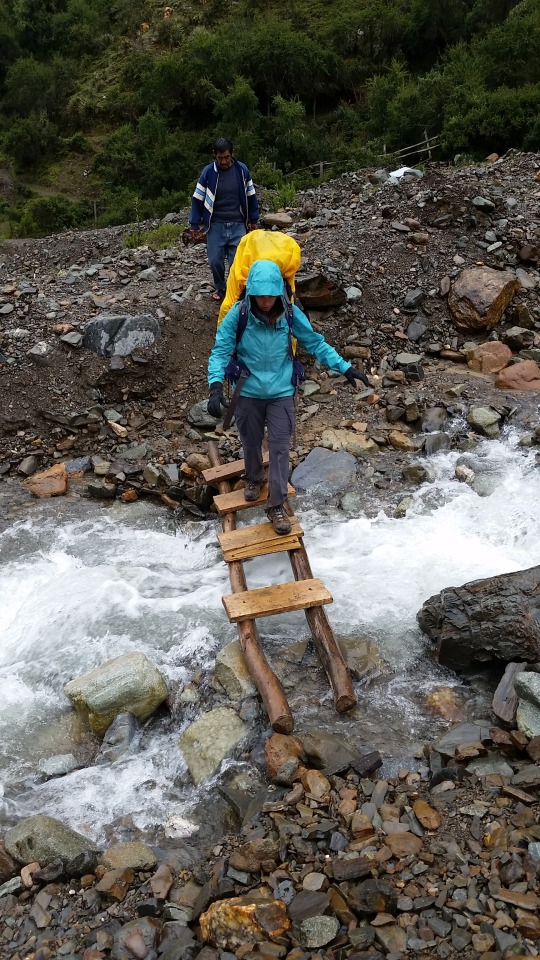
After this point we were so exhausted that we asked the first place we got to if we could camp there for the night. They said no, but pointed us in the direction of Señor Antonio, and his lovely family Roxanne and Sadie. They had a shelter that we could set up our tent in, with another side to cook in. Now you may be thinking at this point, oh that’s lame, you should have just camped outside. But did we mention before in this post that it was raining? And not just a drizzle, but crazy full-blown rain storm while being 1 or 2 degrees Celsius outside. So, paying 20 soles for cover was likely major gringo prices but they were a very nice family, we were frozen, and setting up our tarp/ground sheet/tent did not sound like a fun proposition in the rain. Cover also gave us a chance to ‘try’ to dry out wet clothes, but we ended up just freezing them instead.
So at the end of day number 1, aside from being cold and wet, and wet and cold; we were 9 hours of hiking from Mollepata to Sorraypampa, covering 20 km and gaining about 1 km in altitude. Our total costs for the day were 30 Soles for the collective (15 soles per person) and 20 Soles for our camping arrangements. Our estimated food costs (that we brought with us) were about 50 Soles total. Total day cost in CAD was about $40.
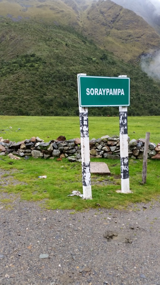
youtube
1 note
·
View note
Text
ALTERNATIVE TREK TO MACHU PICCHU - LARES TREK AND INCA JUNGLE
LARES TREK
Lares: where is it located? How high is it?
Where is Lares located?
Lares is located in the Andes Mountains, in southern Peru. This district of Cusco belongs to the province of Calca.
How high is it? Lares is 3,150 meters above sea level (m.s.n.m.).
What is the weather like in Lares? The climate in Lares is temperate with cold at night. The average temperature is 11ºC. During the day, the heat can reach 21ºC. At night, temperatures can reach 1ºC.
How to get to Lares? Lares is separated from the city of Cusco by 149 kilometers of highway. From this point, it is reached through a car trip that goes through the towns of Pisac and Calca in the Sacred Valley of the Incas.
What to see and do in Lares? Lares has several tourist attractions such as:
Lares thermo-medicinal baths. Mantto Falls. The hiking route to Machu Picchu. Lares is famous for being the starting point of the so-called Lares Trek, a route that leads to Machu Picchu on a 4-day, 3-night road.
More about the Lares Trek
Is it difficult to do the Lares Trek?
The Lares Trek has a medium difficulty. Compared to the Inca Trail or the Salkantay Trek, this route is less arduous. The only difficulty is altitude sickness, due to trails located in high altitude geographies.
When is the best time to do the Lares Trek? The best time to do the Lares Trek is during the dry season (from April to October). In those months, the sky is clearer and there is less chance of rain. Therefore, the roads are in better condition for hiking.
How to fight altitude sickness on the Lares Trek? One of the biggest difficulties during the Lares Trek is altitude sickness (also known as 'soroche').
The best way to combat this disease is acclimatizing to the city of Cusco a few days before the trek.
Another option is to drink plenty of water. Coca tea, for example, is a drink based on coca leaf that effectively fights the ailments and symptoms of soroche.
The Incas, as well as the inhabitants of the Andes to this day, chew coca leaves as a remedy for this and other ailments.
Is it possible to do the Lares Trek on your own? There is no restriction for a visitor to be encouraged to do the Lares Trek on their own. However, unlike other hikes like the Salkantay Trek or the Choquequirao Trek, the trails are not well signposted, making it difficult to stay on course.
To do the Lares Trek on your own you must understand the route to follow. For this, a good map would be effective. Furthermore, the inhabitants that inhabit this region are mainly Quechua speakers.
What to bring to the Lares Trek? The tour services that lead to the Lares Trek include the basic implements such as tents, food and a pack horse.
In addition, it is recommended to bring the following:
Sleeping bag.
Trekking poles.
Hat or cap.
Sunscreen.
Warm clothes during the nights.
Light clothing during the day.
Poncho for rains.
Bottle with water
Hiking shoes.
Bath clothes (for Lares thermo-medicinal baths).
Snacks
Photographic camera.
Extra money.
Recommendations during the Lares Trek The Lares Trek is the route that crosses high-altitude landscapes until you reach Machu Picchu. On the route you can see the beautiful landscapes and indigenous peoples with ancestral traditions.
For a perfect trip it is recommended:
Acclimatize to the city of Cusco before doing the trek. Thus, the symptoms of altitude sickness will be avoided. It is not necessary to be in optimal physical shape to perform the Lares Trek. However, a little pre-workout before the hike would do. Chewing coca leaf during the tour (as the Incas did hundreds of years ago). Another alternative is to take a pill against soroche before starting the trek. The Lares Trek is a great opportunity to learn about the way of life of the peoples that inhabit the Andes. These people offer their products made from alpaca fiber at lower prices than the stores in Lima, Cusco or other countries.
INCA JUNGLE
What is the Inca Jungle at Machu Picchu? The Inca Jungle tour is a tour that departs from the City of Cusco and ends in Machu Picchu, after 4 days and 3 nights after performing a series of adventure sports such as: cycling, trekking, canoeing and zip line. The Inca Jungle is one of the most popular tours in Peru. What is the weather like during the Inca Jungle? The climate during the Inca Jungle is varied. The coldest point is in Abra Málaga (average temperature of 9ºC during the day). Then we descend to the tropical climate of the jungle eyebrow. The warmest point is in the town of Santa Teresa (day temperature up to 26ºC). What is the flora and fauna like during the Inca Jungle? The Inca Jungle is characterized by the beautiful landscapes during the tour. Along the way you can see vizcachas, llamas, spectacled bears, cock of the rocks and a wide variety of orchids. In addition, plantations of bananas, mangoes, oranges and more are crossed. Does 4 days seem too long for the Inca Jungle? There is another 3-day service, which accelerates the pace of the walks to reach Machu Picchu earlier. However, the most popular Inca Jungle tour is the one that lasts 4 days.
What sports does the Inca Jungle include? The Inca Jungle includes the following adventure sports:
Cycling (included).
Hike (included).
Canoeing (not included).
Zipline (not included).
Who can do the Inca Jungle? The Inca Jungle is available for tourists of all ages. However, the tour is recommended for tourists in good physical shape. Older adults should consult their doctor before the tour. Minors must be accustomed to physical efforts and take the tour in the company of their parents.
#travel#Travel Peru#Peru Travel#travel to peru#travel cusco#lares#Lares Trek#lares trek to machu picchu#larestrek#Lares Valley#Inca Jungle#inca jungle trail#incajungle#inca jungle to machu picchu#INCA JUNGLE PATH#cusco#peru
0 notes
Text
Classic Inca Trail (4 days / 3 nights)
The yellow line highlighted on the map indicates the classic 4J / 3N route that generally starts from KM82 (at 2,600 m). Some trekking companies start from KM88, but this is rare because cars cannot go as far as KM82. If you travel by train from Cusco, it is possible to leave KM88, but the route from this starting point joins the KM82 route very quickly, so there are no significant differences in the departure experiences. The total distance traveled between KM82 and Machu Picchu is 45 km and reaches a maximum altitude of 4,200 m. It is a moderately difficult hike that can be completed by most people, provided they are in good shape and well acclimatized (more on that below). Note: the map is not to scale and the route, particularly with respect to camping sites, may vary from one travel agency to another.
Inca trail permit
Permits for the Classic Trail route are strictly limited and almost all dates are sold months in advance each year. This applies to all operators! If you want to book on the classic pilgrimage route and find exhausted permits for your preferred dates, we recommend you choose a hike from Lares or Salkantay.
Typical Inca Trail Route
Below is a typical route for the classic 4D / 3N route. Note: Although the classic hike is 4D / 3N, most agencies organize their hotels before and after the hike, which means that most of the excursions are actually 7D / 6N (with an acclimatization day).
Day 1: Cusco - Ollantaytambo - KM82 - Wayllabamba
The first day is a trip by car or bus in the morning through the Sacred Valley and a relatively easy walk of approximately 12 km. Your tour operator will pick you up from your hotel early in the morning (usually between 5 a.m. and 6 a.m.) and take you from Cusco to the Sacred Valley (some companies start their tour in Ollantaytambo). The trip takes approximately 3 hours to reach the starting point, called KM82 (called, 82 km by train from Cusco). Along the way, you will pass through the villages of Chinchero, Urabamba and Ollantaytambo. You can stop for about an hour in Urabamba and Ollantaytambo, where you can have breakfast and last minute supplies. The KM82 trail first crosses the Vilcanota River (often called the Urabamba River) before climbing the Cusichaca River to a small local town. From there, the Urubamba mountain range (or Urubamba mountain range) will be perfectly visible, with the impressive Monte Veronica (5,860 m) that reveals its icy summit.
Mont Veronica (5680 m / 18635 feet). Veronica is the highest peak in the Urubamba Range. His Quechua name is Wakay Willca, which means "sacred tears." This image was taken on the other side of the sacred valley, near the Abra Málaga pass. On the other side of town, you will see an Inca fort called Huillca Raccay, which was built as a strategic landmark in the Urabamba Valley and was probably used to control the Cusichaca Valley. You can also see, under you and across the river, another impressive site called Inca called Patallaqta. Patallaqta was discovered by Hiram Bingham in 1911, during his trip with Machu Picchu. It is a great Inca ruin that would have been an agricultural colony used to cultivate and feed the inhabitants of Machu Picchu.
Llactapata, an impressive Inca ruin discovered by Hiram Bingham in 1911
The road continues for 7 to 8 km in a series of progressive undulations towards the small town of Wayllabamba, which means "grassy plain" in Quechua and sometimes spells Wayllapampa (3000 m). You will probably camp here at night, although some trekking companies continue a little further to the camps near Ayapata (3,300 m). Wayllabamba is the point where hikers on the Salkantay / Inca Trail walk join the Inca trail. It is also the last place on the trail where pack animals are allowed.
Day 2: Wayllabamba - Llulluchapampa - Warmiwanusca - Pacamayo
When you wake up early, you will have breakfast and prepare for the most difficult day of walking along the way. Day 2 is a trekking distance similar to Day 1, about 12 km, but it involves climbing and going through the Warmiwanusca Pass (also known as the Pass of the Dead Women), a 4,200 m crossing. The start of the walk is simple. After your first hour of walking, you will arrive at a bridge that crosses the Huayruro River. Here is a camp that has baths, so if you feel the call of nature in the morning, it would be better to wait until you reach this point. It is interesting to note that Huayruro refers to a small tree with red and black seeds, colors that are commonly seen in the ponchos of Ollantaytambo carriers. For this reason, goalkeepers in this region are often called Huayruros. From there, the trail begins to harden, crossing a piece of cloud forest that finally reaches the small town of Llulluchapampa (3,680 m) after approximately 3 hours of walking. From there, it will take another hour and a half to reach the top of the Warmiwanusca pass (also known as Abra de Huarmihuañusca or "Passage of the dead woman"), located at 4,200 m. The trip can be hot and intense if the sun rises (be sure to use sunscreen), or cold if it is cloudy / foggy and the wind rises. Make sure you have layered clothes so you can place it as much as necessary.
The view from the Passage of the Dead Woman, 4,200 m, on the Inca Trail
After celebrating your successful ascent to the highest point of the classic Inca trail, you will descend approximately 2 km along a steep path that leads to the overnight camp, located in Pacamayo (3600 m). You'll be glad to know that there are toilets in this camp. Note on the Dead Women Pass: it bears this name, not because a woman died in the pass, but because the slope of the mountain, seen from the descending valley, looks like a liar woman.
Information that may interest you:
peru choquequirao trek
inca jungle trail to machu picchu
honeymoon to peru
famous monuments in peru
sacred valley of the incas attractions
incan sun god
palcoyo mountain tour
Day 3: Pacamayo - Runkurakay - Sayacmarca - Phuyupatamarc - Winay Wayna
The third day is another difficult day that covers about 15 km and crosses two small passes. The day begins with a one-hour walk to the ruins of Runkuracay, an Inca site that is believed to have served as a watchtower over the Pacamayo Valley. After another hour of walking, you will reach the second step on the classic Inca trail called Runkuracay Pass (also known as Abra de Runkuracay), located 4,000 m away. From here, the trail consists of beautifully paved Inca trails and stairs. The first staircase downstream of the Runkuracay pass is relatively steep, so watch your feet. An hour after the second step, you will reach Sayacmarca, an Inca ruin with a beautiful stone staircase. Sayacmarca is not yet intended to be used, but the name of the site means "Inaccessible City," which accurately describes the well-protected position of the site at the foot of three steep cliffs. From there, the road passes through an original Inca tunnel before climbing to the third and last step at 3700 m. On a clear day, you will have a fantastic view of Salkantay (6,217 m) to the south and Veronica (5,860 m) to the north. Just after the pass, you will arrive in Phuyupatamarca, one of the most impressive sites of the Incas along the way (Machu Picchu bar). Phuyupatamarca or Puyupatamarca is also known as "The city between the fog" (The city above the clouds) because it is 3,200 m. Access to the site is through a steep path that crosses 5 original Inca baths that may have been used for spiritual or ritual reasons.
Phuyupatamarca or Puyupatamarca is also known as "The city between the fog" ("The city over the clouds")
Upon leaving Phuyupatamarca, you will be presented with an original Inca staircase of 1,000 steps. Prepare your knees for a difficult descent. Go slowly and make sure your foot. After 2-3 hours of hiking through the cloud forest, you will arrive at Winay Wayna camp (Quechua name for "Forever Young"). Just south of the camp are the ruins of Winay Wayna, an area that probably served as a final resting place before reaching Machu Picchu. Before arriving at Machu Picchu, the site contains a series of Inca baths that were probably used as ritual cleaning areas.
Wiñay Wayna, an Inca site located near the last camp of the same name, on the Inca Trail
Day 4: Winay Wayna - Inti Punku - Machu Picchu - Aguas Calientes - Ollantaytambo - Cusco
From Winay Wayna, you wake up early (around 04:30 a.m.) for breakfast and start an hour and a half on foot to reach Inti Punku (the door of the sun). For the first part of this hike, you may need to use a lighthouse (see the packing list for the Inca trail below), although most operators do not hire it until around 5:30 a.m. When the sun rises . The goal of early departure is to try to capture the sunrise over Machu Picchu, which takes place between 06:30 and 07:00. The trail from Winay Wayna follows a contour curve in the cloud forest before reaching a steep stone staircase, 50 in total, which leads to Inti Punku. At the top of the stairs, you will be presented with an unforgettable view when the famous Inca site of Machu Picchu is revealed.
The view of Machu Picchu from Inti Punku (the door of the sun)
You can enjoy the first views of Machu Picchu from Inti Punku for approximately 30 to 40 minutes before descending a gradual path through the citadel. From there, you register with the authorities and store your backpack. Most tour operators organize a full city tour for two or three hours before giving them free time to explore the ruins. If you still have energy and are not afraid of heights, we recommend that you reserve your place, before reaching Machu Picchu, for the ascent of Huayna Picchu (the emblematic mountain behind Machu Picchu). There are only 400 climbing permits per day and two departure times: 7:00 a.m. and 10:00 a.m., as with the Inca Trail, it is important to book in advance. Here you will find detailed information about climbing the Huayna Picchu or Mount Machu Picchu.
The view of Machu Picchu from Huayna Picchu (also known as Wayna Picchu or Wayna Pikchu)
After exploring Machu Picchu for a few hours, you should take a bus or get off at the city of Machu Picchu (also known as Aguas Calientes) in the valley below. The bus trip is usually included in the price of your excursion on the Inca trail, but the descent, which lasts approx. It is worth taking into account 2 hours, as it offers a fantastic view of the terraces of Machu Picchu. Most tour operators have booked a mid-afternoon train trip to Ollantaytambo, where they will also organize a private bus / car to take you back to Cusco. If you leave Aguas Calientes at 3:00 p.m., you will return to Cusco around 8:00 p.m. Note: You can also make an itinerary of the Inca Trail 5D / 4N that includes a night in a hotel in Aguas Calientes and an additional day in Machu Picchu. This is ideal for those who wish to spend more time in Machu Picchu (perhaps climbing Mount Machu Picchu or Putucusi) and offers the possibility of visiting the hot springs of Aguas Calientes. If you are looking for a shorter trekking experience, the "Short Inca Trail", presented below, is for you.
Information that may interest you:
rainbow mountain peru tour
machu picchu 2 days 1 night
machu picchu opening dates 2020
machu picchu by train
Humantay
Inca Road Cusco Peru
Trek to Machu Picchu
#classic inca trail#Inca Trail#Inca Trail Peru#Inca Trail to Machu Picchu#the inca trail to machu picchu#machu picchu inca trail
0 notes
Text
How to Push Through Phases of Uncertainty
“I beg you, to have patience with everything unresolved in your heart and to try to love the questions themselves as if they were locked rooms or books written in a very foreign language. Don’t search for the answers, which could not be given to you now, because you would not be able to live them. And the point is to live everything. Live the questions now. Perhaps then, someday far in the future, you will gradually, without even noticing it, live your way into the answer.” ~Rainer Maria Rilke
I once trekked on my own along the Salkantay Trail in Peru between the town of Mollepata and the magnificent Machu Picchu. The journey in total was fifty miles, and it took me four days. I had never backpacked before, let alone on my own, let alone in a foreign country, but the opportunity was appealing.
Along the way, I learned four important lessons that have helped me accept and makes sense of phases of uncertainty. But before I share those, a little backstory:
The year prior, I experienced many internal challenges. In a short time, I transitioned from having clear direction in my life and knowing what was important to me to having no grasp of what I wanted and feeling lost. The feeling was unfamiliar to me. I had spent much of my life plowing forward, knowing exactly what I wanted, why, and how to get there.
Almost two years before my trip to Peru, I had just finished working breathlessly on a local political campaign for the 2016 election. The candidate lost, and the outcome of the presidential election left me feeling even more defeated.
Shortly after, I traveled to Thailand for three weeks with a friend. When I returned to the states, I was unsure of where I wanted to place my next step. I was still feeling politically fired up, and with that energy I decided to start a nonprofit organization in my state to encourage women to run for office.
I worked day in and day out putting together statistics, a website, a business plan, and coffee dates with important people in the community. It didn’t take long for the organization to gain momentum because it attracted the support of people who were also intensely moved by the election.
Meanwhile, I entered into a tumultuous and emotionally exhausting relationship, I moved to a different town after living in my parent’s basement, and I was seeking full-time work to pay bills that I barely had the money to cover. I felt split between two worlds: one of chaos and one of professionalism. In my naive mind, I believed those two world existed separately, and I couldn’t find my place in either one.
When I jumped on the opportunity to start an organization in my community, I wasn’t fully aware of how demanding it would be. Just as it started to gain momentum, I secretly knew I didn’t want to be part of it long-term.
I knew I was capable of building the organization, but I was also young and inexperienced, insecure, and distracted by the ambiguity of being a fresh college graduate. I chased after a shiny object that I, as I got closer, discovered wasn’t something I was as interested in as I initially thought.
A year after the organization started, I resigned from the Board of Directors. We then decided to dissolve the organization altogether, and I breathed a major sigh of relief.
Around the same time my boyfriend and I split for the second or third time. I was left in a state of confusion and felt defeated again, but it was a different type of defeat. It was a feeling of intense vulnerability. I felt exposed and lost—two feelings I’ve always been good at avoiding.
When I decided to trek fifty miles through the Andes Mountains, it was an attempt to find clarity. I hoped that hiking by myself in nature would bring sudden insight into what I had just experienced and what I needed to do next.
I instead learned that clarity doesn’t arrive just because we demand it. Rather, clarity comes in its own time, typically after one has endured the uncomfortable but often necessary road of uncertainty.
If you’re currently facing uncertainty in your career, relationships, or any other area of your life, perhaps some of my other lessons will be helpful to you.
1. It will be painful—keep going anyway.
On the third day of my hike, I grew nasty blisters on the heels and toes of my feet. I also felt a throbbing pain on the inside of my calves. Halfway through the day, simply putting weight on my foot became the most painful task.
I was walking by myself on a dirt road, and I had no idea how much further I had to walk before reaching my campsite. I wasn’t even confident I was headed in the right direction.
Okay, just walk to that point, I’d tell myself, looking about 100 meters ahead where the road curved or changed in some way. Maybe the view will change once you get there, I thought.
A different view meant that I might suddenly see my campsite in the near distance. Not knowing kept me going because there was always the possibility that I was meters away from resting.
Breaking the hike down into smaller chunks also helped me to stay motivated. If I imagined the total distance I had left to go, it was overwhelming.
A journey of uncertainty guarantees pain. It’s uncomfortable. It’s vulnerable. It’s frustrating. Sometimes we want to lay down in the middle of the road and give up. It feels easier to stay in the same place than to walk toward something that’s unknown.
But with uncertainty, there is no way out but through. Try to break it down into more manageable parts—can you make it through the day? The week? The next month?
With uncertainty, you never know when you might turn the corner and suddenly see answers in sight. Tomorrow might offer insight, so why stop now?
2. Distractions don’t solve uncertainty.
The beauties of traveling alone are many, but they always come with a degree of loneliness. In Peru, it was difficult to wake up cold and alone in a tent, knowing I only had myself to talk with. I would’ve much rather reached my arm across to pull a warm body close.
I was jealous of the couples I had encountered on the same trail who were hiking together. I was frustrated with my loneliness and annoyed with myself for being alone.
Really, what I wanted was love to distract me from the uncertainty I was facing in my life. But I knew that if I wallowed in what I wanted instead of what I had to do, which was to pack my tent and all my other belongings into my backpack and move forward, I would stay stuck in the same place and wouldn’t get any closer to my destination.
When we’re caught in a phase of uncertainty, it’s tempting to attach to distractions that’ll keep us from focusing on the discomfort we feel. The most appealing distraction when confused about life is to chase after opportunities that aren’t necessarily best for us. The panic we feel when we lack direction is so strong that we would rather seek mediocre, senseless options than to stay in the uneasiness as we wait for clearer direction.
Ultimately, waiting for direction leads us to our greater purpose. But we can’t follow the direction if we’ve already made a decision based on fear.
3. Trust that there will be guides.
The first time I went the wrong way along the trail was on day one. I had just walked through some sort of political event. Interested citizens sat along a ledge while they listened to a well-dressed man speak in a confident tone.
After I passed, I took a left turn at a crossroads. I heard a voice behind me and turned around. It was one of the men from the group, pointing the opposite direction. He had followed me a few steps up the trail, making an effort to redirect me. “Salkantay?” I said. He nodded.
On the third day, I arrived at a small village where a family of three lived. After hiking a steep hill, I sat on a wooden stump by their home to rest. I bought and devoured two passion fruits from their garden.
On my way out, I turned right on a dirt road. A boy about two years old saw me and pointed left. “Salkantay?” I said. He cocked his head. “La Playa?” I said, the town where I was headed. He nodded and pointed left again. I turned around and continued to hike along the dirt road.
On the last day, I passed a turn I needed to take. My senses stopped me. I had just passed a few hikers, and they weren’t behind me any longer. I pulled out a book of directions (which I’m never good at understanding), walked back, and found the small path that led me into the mountains.
Without unfamiliar faces along the way to guide me, I would’ve easily wound up lost in the Andes Mountains. Maps and written directions aren’t always helpful when standing in a specific place.
Sometimes, finding the way requires trust. If you haven’t found a sign to help guide you on your path of uncertainty, have faith that it’ll arrive in the right moment. The only way to find the signs is to keep walking—keep taking action and trying new things. The signs and guides are waiting for you to arrive.
4. Take good care of yourself.
Near the end of the trek, when my feet were blistered and my legs swollen, it was important that I had enough time to rest before the next day. I knew that in order to push forward, I had to take care of my body.
I spent the evenings stretching, massaging my muscles, and wrapping tape around my blisters. Though the pain would still be there the next morning, it was a little more manageable than the night before. The pain had subdued just enough that I knew I could continue hiking.
Since we’re never sure when a phase of uncertainty will end, it’s critical that we take care of ourselves throughout it. Creating time to rest and take care of ourselves—which for me is getting enough sleep, exercising, and journaling – ensures that we will have enough energy to push through the discomfort we feel.
It’s when we lose our energy that we cling to distractions, miss important signs along the way, or give up. Trust that no matter how difficult a single day is, there is always space to pause and take a deep breath. Sometimes that’s all you might have energy for, and that’s okay. Without rest, there is no journey.
—
On my flight out of Peru, I peered out the window at the many trails that marked the earth’s skin like scars. I thought about the trek I had just experienced. I wondered, what did the trail look like from the sky?
I imagine a life’s journey looks similar. It curves and zig-zags through different terrain; some parts uphill, some downhill. It’s never a straight line.
Uncertainty is a natural and guaranteed part of life. A journey isn’t intended to be seen from a birds-eye view. It’s rather meant to be lived in the moment through our own experiences. We don’t need to know what lies beyond what’s right in front of us. We’ll reach it eventually, in the right time.
There are moments when we reach a lookout point and can make sense of the larger picture of our lives. From that perspective, we can look back at the journey we just accomplished. We can understand the connection between the series of events that have created our lives up to that point.
But more often than not, we don’t have the ability to see our journeys from the lookout point. We instead see what it looks like right in front of us: a steep hill, thick trees blocking the view, and no signs in sight. We have doubts about what lies ahead.
When we trust that there’s a grander view of the trail we see directly in front of us, we can muster the energy we need to carry us to a day when, finally, we reach a lookout point. From that view, everything makes sense. Trust that, regardless of what it looks like now, the lookout points are waiting for you along your path.
About Samantha Case
Samantha is a writer, a wanderer, a spiritual seeker, and a full-time student of life's experiences. She generally writes about self-growth and the deeper meaning behind life's experiences. Samantha runs Taproot Theory, a blog that focuses on living a life of intention, meaning, and purpose. Find the blog at www.taproottheory.com or on Instagram @taproottheory. In her free time, Samantha travels and explores the woods.
Web | More Posts
Get in the conversation! Click here to leave a comment on the site.
The post How to Push Through Phases of Uncertainty appeared first on Tiny Buddha.
from Tiny Buddha https://tinybuddha.com/blog/how-to-push-through-phases-of-uncertainty/
0 notes
Text
New Step by Step Map For Salkantay trek business
We will get you off the path as swiftly and easily as you can, if desired and will you should definitely get straight to a clinic for cure. it's not one thing to worry about – but if some thing comes about, we is going to be there for you. Peru Rail teach pulls by Aguas Calientes Upon locating our hostel for that night time, I showered and handled myself to some one particular hour massage, accompanied by espresso as well as a piece of wealthy chocolate cake. On Day one we almost had the trail to ourselves Besides a pair trekking by using a guidebook. On working day 2, we shared the trail with that few, together with One more little group of trekkers. Horses have the food items, gas and tenting equipment Refocusing within the path, the sights ongoing for getting prettier and prettier as our hearts conquer tougher and tougher. Camp the primary evening inside our personal campsite for the skirts of Salkantay mountain surrounded by breathtaking views with the snow capped peaks. In the evening take pleasure in the stargazing by utilizing our telescopes and study the inca constellations. It is nearly difficult to forecast how altitude will outcome you as there is very little correlation concerning altitude sickness symptoms and age, Physical fitness level, gender etc. We do on the other hand realize that likely much too superior much too quickly They all agree that their instruction is never performed, and every year we research that has a professor to ensure we've been real industry experts. Our chefs also fine tune their capabilities with lessons every February. PORTERS The lack of other people was an unanticipated shock, and crystal clear advantage to trekking inside the reduced season. We provides you with your duffel bag at your briefing the night in advance of and This could be crammed with the things you need for evening and the following day. you won't have usage of your duffel until finally your evening campsite. sitting down there at the desk, brain full of uncertainties about regardless of whether I was seriously in shape for this trek, one of the Dutch girls said a thing that snapped me back into truth. I hardly completed fifty percent my plate, Even with understanding food items is Vitality, and I needed as much as you possibly can. I relied on chocolate and copious quantities of drinking water as a substitute. inka trail to machu picchu hike to machu picchu There are 2 primary seasons from the sub-tropical Peruvian Andes – a dry time that operates from late April through to early October, in addition to a moist period that starts mid to late October and attracts to an in depth in April. If any of these consequences develop into critical, remember to Call our Workplace and we can help you get to a doctor. peru videos it's essential to understand that This is certainly your vacation and you do not choose to tension out about the possibility of having Ill from your mountains. Do anything slowly but surely.
0 notes
Text
Map Salkantay Trek: Your Route to Machu Picchu with Alpaca Expeditions
The map Salkantay Trek by Alpaca Expeditions is your ultimate guide to one of Peru's most breathtaking trails, leading from the Andean peaks to the iconic Machu Picchu. Starting at Soraypampa, the trek includes highlights like the serene Humantay Lake and the challenging Salkantay Pass at 4,650 meters. As you descend into lush cloud forests, you'll pass through remote villages like Chaullay and Collpapampa. They ensure you experience the trek's full beauty, with expert guidance through its diverse landscapes and rich cultural heritage. Ending at Machu Picchu, this adventure offers a unique journey for those seeking both challenge and discovery.
For more Information
Visit us: www.alpacaexpeditions.com
Mobile No : (+51) 84 254278
EMail Id : [email protected]
0 notes