#runway18
Explore tagged Tumblr posts
runway18 · 6 years ago
Video
9V-SWB Singapore Airlines Boeing 777-312(ER) @ Frankfurt (FRA / EDDF) / 12.03.2017 www.runway18.de von Oliver Holzbauer Über Flickr: 9V-SWB Singapore Airlines Boeing 777-312(ER) @ Frankfurt (FRA / EDDF) / 12.03.2017 www.runway18.de
4 notes · View notes
aviationdailynews-blog · 4 years ago
Text
Aviation Weather - METAR
Aviation weather METARs or Meteorological Terminal Air Reports
Definition
Meteorological Terminal Air Report (METAR) are the aviation weather reports issued frequently throughout the day that are a current snapshot of the current conditions at an airfield.
What is contained in a METAR?
The elements of these aviation weather reports are normally given in the order below.
Code Name
The indicator group for example METAR, SPECI, or TREND as appropriate. Where a number of METARs are issued in the same bulletin, this, along with a date time group may be in the bulletin header.
Location
The ICAO airport code of the reporting station (KJFK - JFK Airport).
Date/Time of Report
The day of the month and the time of the aviation weather observation in hours and minutes based on UTC time, this is shown as 011530z which would be the first of the month at 1530z.
AUTO
If a report contains the code word AUTO, this indicates that the report has been generated using data from an automated weather observation system.
Surface Wind
The reported wind is the mean wind direction in degrees true to the nearest 10 degrees, from which the wind is blowing and the mean wind speed in knots over the 10 minute period immediately before the observation, Metar wind reports will be shown for example as 35015KT, in plain language this would equate to 350 degrees true(direction) at 15 kts(speed).
Alternatively a wind report such as VRB05KT means that surface wind conditions cannot be shown, in this example VRB05kts would translate into a plain language equivalent of variable wind direction with a wind speed of 5kts.
Having a surface wind readout of “00000” means that the surface wind conditions are calm.
If gusts exceed the mean wind speed by 10kts or more in the 10 minutes leading up to the observation time of the report, the letter G and 2 more numbers are added to indicate the maximum wind speed, for example 23018G30KT translates to a wind from 230 degrees true with a maintained wind of 18 kts but the wind is also gusting up to a maximum of 30 kts.
Reports vary around the world as different regions offer wind speed in different measurement units, therefore it must me mentioned that Metar reports may express wind speed in metres per second (MPS) or Kilometres per hour (KPH).
Wind speeds of 100 kts or more shall be preceded by the letter P and reported as P99KT or P99MPS or P199KPH.
Visibility
Reported in a four figure group (for example 0300 = 300 metres; 9000 = 9 km) up to but excluding 10 km, therefore a reported visibility of “9999” is considered as having a visibility of 10km or more. In very poor conditions “0000” may be reported, this means that there is less than 50 meters visibility.
Runway Visual Range (RVR)
This number may be included in reports during poor or reduced visibility. This report will be preceeded by the letter R (runway) followed by two numbers (runway identifier), there will then be a “/” followed by 4 digits. This means that a report such as R18/0250 would mean that Runway18 has an RVR of 250 meters.
In the case of parallel runways these will be shown as R18L with the L being for runway 18Left, (there can only be 3 options here L, C, or R - Left, Center & Right)
RVR will only normally be issued for visibility less than 1500, therefore a visibility above this number (if presented on a metar) will have a P before the 1500 figure, so a readout such as R18R/P1500, would mean that runway 18Right has an RVR of greater than 1500.
RVR in most situations has a minimum readout of 50, which means that an M before the 4 digit visibility means the value is below what the measurement equipment can gather, in this case a report of 18C/M0050 would mean that runway 18Center has an RVR less than 50.
RVR values can have the letters U, D, or N following their readout, this is a code to show if the RVR is increasing, decreasing, or no change is expected.
Current
Weather
The current weather is indicated by up to 3 groups comprising symbols and letters from the following:
- = slight
+ = Heavy
BC = Patches
BL = Blowing
BR = Mist
DR = Low Drifting
DS = Dust Storm
DU = Widespread Dust
DZ = Drizzle
FG = Fog
FC = Funnel Cloud (e.g. Tornado)
FU = Smoke
FZ = Freezing
GR = Hail
GS = Small Hail
HZ = Haze
IC = Ice Crystals
MI = Shallow
PL = Ice Pellets
PO = Dust Devils
RA = Rain
SA = Sand
SG = Snow Grains
SH = Shower
SN = Snow
SQ = Squall
SS = Sandstorm
TS = Thunderstorm
VA = Volcanic Ash
VC = In the vicinity (nearby)
UP = Unidentified Precipitation
RE = Recent
These codes can be coupled, so for example +SHRAGR could be output, this would mean that there is currently (+)heavy (SH)showers of (RA)rain & (GR)hail.
Clouds
Cloud amount is reported in oktas, this means that if you looked at the sky and split this view in 8, each section would be 1 okta, how many oktas are covered will give certain reports which are shown here:
1. FEW = few clouds (1-2 oktas),
2. SCT = scattered cloud (3-4 oktas),
3. BKN = broken clouds (5-7 oktas),
4. OVC = overcast (8 oktas).
Following this 3 letter code will show a 3 digit number which represent the cloud base which is reported as a height (in feet) above aerodrome elevation. For example a readout of SCT018 means that there is scattered clouds at 1800 ft. *Note that in area and route forecasts, heights are AMSL or standard pressure altitudes.
Selection of cloud layers reported is made as follows:
· The lowest Layer;
· The next lowest layer of SCT or more;
· The next higher layer of BKN or more;
· Significant convective cloud (CB or TCU) if not already reported.
“Sky obscured” is input on a METAR as VV(vertical visibility)this figure again is is a set of digits which represents hundreds of feet. If the vertical visibility has not been measured, the report will read VV///, which means it has not been measured.
When there are no clouds that are of operational significance to aviation, this means no CB (cumulonimbus) or TCU (towering cumulus) and CAVOK is not appropriate, the abbreviation NSC (No Significant Cloud) will be used.
CAVOK
The Visibility, Cloud, and Weather groups are replaced by the term CAVOK (cloud and visibility OK) when the following weather conditions exist at the same time:
· Visibility is 10km or more.
· No CB or TCU and no cloud below 5000 feet or Minimum Sector Altitude (MSA) (whichever is the greater).
· No significant weather at or in the vicinity of the aerodrome.
Temperature
Air temperature and dewpoint are reported in METARs to whole degrees Celsius, for example 10/07 would read as “temperature 10°C with a Dew point of 7°C”.
QNH
QNH is stated to the nearest whole hectopascal (equivalent to a millibar) rounded down and preceded by the letter Q to make things shorter, for example Q1013 equals QNH 1013 hectopascals.
Recent Weather
Significant recent weather observed in the period since the last routine observation will be reported by using the code letters for weather (table above) preceded by the letters RE. So for example RETS would mean recent thunderstorm.
Wind Shear
In a METAR, civil aerodromes may include wind shear if reported along the take off or approach paths in the lowest 1600 ft with reference to the runway. WS is used to begin the group, e.g. WS TKOF RWY20. If the wind shear is affecting all runways, WS ALL RWY is reported.
Aerodrome Color State
UK military and USAF aerodromes will include the abbreviated colour state at the end of the message and add the forecast colour state after the TREND section.
Runway State Group (RSG)
An 8-figure group which may be added to METAR from civil aerodromes.
· Runway designator (first two digits)
27 = Rwy 27 or 27L
77 = Rwy 27R (50 added to the designator for "right" runway)
88 = All runways
99 = repetition of the last message as no new information received.
· Runway Deposits (third digit)
0 = Clear and dry
1 = Damp
2 = Wet or water patches
3 = Rime or frost covered (depth normally less than 1mm)
4 = Dry snow
5 = Wet snow
6 = Slush
7 = Ice
8 = compacted or rolled snow
9 = frozen ruts or ridges
/ = type of deposit not reported
· Extent of runway contamination (fourth digit)
1 = 10% or less
2 = 11% to 25%
5 = 26% to 50%
9 = 51% to 100%
/ = not reported
· Depth of Deposit:
The quoted depth is the mean of a number of readings or, if operationally significant, the greatest depth measured.
00 = less than 1mm
01 = 1mm etc
to
90 = 90mm
91 = not used
92 = 10cm
93 = 15cm
94 = 20cm
95 = 25cm
96 = 30cm
97 = 35cm
98 = 40cm or more
99 = Rwy(s) non-operational due to snow, slush, ice, large drifts or runway clearance, but depth not reported.
// = depth of deposit operationally not significant or measurable.
· Friction Coefficient or Braking Action (seventh and eighth digits)
The mean value is transmitted or, if operationally significant, the lowest value, e.g.:
28 = friction coefficient 0.28
38 = friction coefficient 0.38
or
91 = Braking action: Poor
92 = Braking action: Medium/Poor
93 = Braking action: Medium
94 = Braking action: Medium/Good
95 = Braking action: Good
99 = Figures unreliable
// = Braking action not reported
If contamination conditions do not exist, the abbreviation CLRD can be used:.
25CLRD93 = Rwy 25 cleared; Braking action: Medium/Good
88CLRD95 = All rwys cleared; Braking Action: Good
TREND
TREND forecasts are indicated by BECMG (Becoming) or TEMPO (temporary) which may be followed by a time group (hours and minutes UTC) preceded by one of the letter indicated FM (from), TL (until), AT (at)
For example BECMG FM1030 TL1130 would mean that the weather will become, from 1030UTC until 1130UTC - followed by the weather within that time.
NOSIG replaces the TREND group when no significant changes are forecast to occur during the 2 hour forecast period.
To indicate the end of significant weather the abbreviation NSW (No Significant Weather) will be used used.
Only those elements for which a significant change is expected should be included in a TREND.
1 note · View note
alizziane · 7 years ago
Photo
Tumblr media
#talbotrunhof #dress #glitter #jewelry #runway #cool #fashion #fashionblogger #fashionista #fashionaddict #lifestyle #lifestyleblogger #trend #trendy#it #itgirl #style #outfit #runway18 #chic
0 notes
socialsf · 7 years ago
Photo
Tumblr media
You are #clearfortakeoff #runway18 @flypenair #CEC > PDX #knowyourpilot #fastenyourseatbelt #weekendescape #northcamp #summerdays #100daysofsummer (at Fly Crescent City)
0 notes
clear-the-runway · 10 years ago
Photo
Tumblr media
Quick flight before school starts
2 notes · View notes
runway18 · 6 years ago
Text
Tumblr media
Derzeit steht der zehnte Airbus A350 für die Fluggesellschaft Ethiopian Airlines im Airbuswerk in Toulouse kurz vor seiner Auslieferung. Der Airbus A350-941, welcher jetzt noch die Kennung F-WZFH hat, trägt künftig den Namen New York und ist am Rumpf mit einem „Celebrating 10th A350“ Sticker verziert.
https://runway18.de/zehnter-a350-fuer-ethiopian-airlines
4 notes · View notes
runway18 · 6 years ago
Photo
Tumblr media Tumblr media
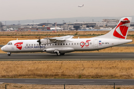
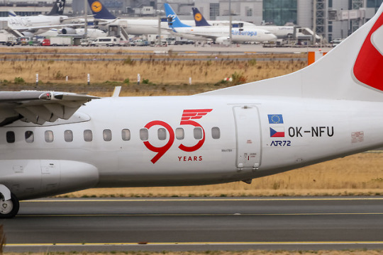
Czech Airlines feiert in diesem Jahr ihren 95. Geburtstag
In diesem Jahr feiert die Fluggesellschaft Czech Airlines ihr 95 jähriges Bestehen und Gründung der Gesellschaft. Am 29. Oktober 1923 nahm die Airline ihren Betrieb auf und flog um 12:35 Uhr von Prag/Kbely nach Bratislava. Ursprünglich war der Flug schon für einen Tag früher geplant, nämlich zum 5. Jahrestag zur Gründung der damaligen Tschechoslowakei. Da aber das Wetter ziemlich schlecht war beschränkte man sich an diesem Tag auf einem symbolischen Rundflug rund um Kbely. Der erste echte Linienflug startete dann einen Tag später.
Mit heute 18 Fliegern in ihrer Flotte, davon die Hälfte mit Airbus A319-100 bestückt, bedient sie seit 2013 auch wieder eine Langstrecke nach Seoul.  Die OK-NFU ziert anlässlich ihres Firmenjubiläums ein 95 Jahre Sticker am Rumpf.
https://www.runway18.de/spotting/czechairlines95jahre/
2 notes · View notes
runway18 · 6 years ago
Video
runway18.de
4 notes · View notes
runway18 · 7 years ago
Photo
Tumblr media Tumblr media Tumblr media
A6-EYF Etihad Airways Airbus A330-243 departing to Abu Dhabi (AUH / OMAA) @ Dusseldorf - Rhein-Ruhr International (DUS / EDDL) / 21.07.2016
www.runway18.de
4 notes · View notes
runway18 · 7 years ago
Video
D-ABVX Lufthansa Boeing 747-430 on taxiway for further departure to Detroit (DTW) @ Frankfurt Rhein-Main International (FRA) / 08.09.2017 von Oliver Holzbauer Über Flickr: D-ABVX Lufthansa Boeing 747-430 on taxiway for further departure to Detroit (DTW) @ Frankfurt Rhein-Main International (FRA) / 08.09.2017
85 notes · View notes
runway18 · 7 years ago
Video
D-AALC AeroLogic Boeing 777-FZN departing on Rwy18 to Leipzig (LEJ/EDDP) @ Frankfurt Rhein-Main International (FRA / EDDF) / 18.07.2016 von Oliver Holzbauer Über Flickr: D-AALC AeroLogic Boeing 777-FZN departing on Rwy18 to Leipzig (LEJ/EDDP) @ Frankfurt Rhein-Main International (FRA / EDDF) / 18.07.2016
www.runway18.de
4 notes · View notes
runway18 · 7 years ago
Video
A6-DDE Etihad Airways Boeing 777-FFX coming in from Abu Dhabi (AUH) @ Frankfurt (FRA) / 08.09.2017 von Oliver Holzbauer Über Flickr: A6-DDE Etihad Airways Boeing 777-FFX coming in from Abu Dhabi (AUH) @ Frankfurt (FRA) / 08.09.2017
2 notes · View notes
runway18 · 8 years ago
Video
D-AIMK Lufthansa Airbus A380-841 lining down after rejected take off to Shanghai PuDong( PVG / ZSPD) @ Frankfurt - Rhein-Main International (FRA / EDDF) / 13.05.2017 von Oliver Holzbauer Über Flickr: D-AIMK Lufthansa Airbus A380-841 lining down after rejected take off to Shanghai PuDong( PVG / ZSPD) @ Frankfurt - Rhein-Main International (FRA / EDDF) / 13.05.2017
29 notes · View notes
runway18 · 7 years ago
Photo
Tumblr media
D-AINA Lufthansa Airbus A320neo - MSN 6801 @ Frankfurt Airport / 15.03.2017 www.runnway18.de
8 notes · View notes
runway18 · 8 years ago
Video
A7-ALG Qatar Airways Airbus A350-941 lining up on Rwy 18 for departure to Dohar (DOH / OTHH) @ Frankfurt - Rhein-Main International (FRA / EDDF) / 13.05.2017 von Oliver Holzbauer Über Flickr: A7-ALG Qatar Airways Airbus A350-941 lining up on Rwy 18 for departure to Dohar (DOH / OTHH) @ Frankfurt - Rhein-Main International (FRA / EDDF) / 13.05.2017
3 notes · View notes
runway18 · 8 years ago
Video
D-AINA Lufthansa Airbus A320-271N(WL) coming in from Oslo (OSL / ENGM) @ Frankfurt - Rhein-Main International (FRA / EDDF) / 15.03.2017 von Oliver Holzbauer www.runway18.de Über Flickr: D-AINA Lufthansa Airbus A320-271N(WL) coming in from Oslo (OSL / ENGM) @ Frankfurt - Rhein-Main International (FRA / EDDF) / 15.03.2017
3 notes · View notes