#rocky fork juniper
Video
Sitt'n Pretty by Christina Saint Marche
Via Flickr:
I dressed in this exquisite Pengnoir set which I had sketched and designed. I saw this copper colored silk fabric a year earlier in Asia and bought it without any idea what I would use it for. One day, months before my anniversary, I sketched this gown and long jacket. I then shipped it off to Trashy Lingerie in Los Angeles which is the "Home of what else? Trashy Lingerie!" They really know how to make a gown and have been around for many years. This is a snippet from the world famous Robin Leach: Told by none other than the expert of The Rich and Famous, Mr. Robin Leach of the television show Lifestyles of the Rich and Famous. ...Where would all of Hollywood's most beautiful women be without the help of Trashy Lingerie? Its owners, Mitchell and Tracy Shrier opened the doors to the tantalizing Tinseltown store almost 25 years ago! With only one store located on La Cienega Blvd in Los Angeles, Trashy Lingerie has worldwide name recognition for providing their rich and famous clientele with only the highest quality of lingerie and clothing. "Our Fantasy is Fulfilling Yours" is their slogan, and let me assure you that is EXACTLY what they do. On any given day you may run into Madonna, picking up another one of her famous Bullet Corsets which Trashy specially designed for her. Or perhaps you might see Pamela Anderson Lee coming in for a fitting for another one of those super low V leather corsets like the one she wore in Barb Wire. Many of Hollywood's stars have come to learn that the "Sky's the Limit", when it comes to Trashy! You may start by looking at one of the over 8000 designs to choose from, all of which are designed by Mitch and his extraordinary design staff. Everything in the store is produced right on the premises. There are 30 seamstresses, handsewers and pattern makers, which makes it easy for them to custom fit all the very different bodies to their original designs. Dolly Parton takes advantage of this free custom tailoring to accommodate the part of her body which is well endowed! Now let's face it, not everybody is comfortable walking into a store which caters to intimate undergarments that spice up your life. Which is exactly the reason that Trashy is not open to the public. It's a private, members-only store. To become a member, you must fill out an application and pay your yearly dues of $5.00. You will then be handed a pink membership card, which entitles you to all of Trashy's privileges. (My card is # 000,001-- I'm proud to let you know that I am one of Trashy's original members. I filmed for Lifestyle of the Rich and Famous and Entertainment Tonight and Mitch and Tracy have become good personal friends.) Today there are over 250,000 members from all over the world. If you were allowed to glance through the many rolodexes surrounding the guarded entrance, you would come across the names of such members as: Cher, (we filmed her lingerie closet in Lifestyles of the Rich and Famous), Traci Lords, Winona Ryder, Roseanne, Elizabeth Berkley, Demi Moore, Christina Saint Marché, Brigette Nielson, Julia Roberts, Goldie Hawn, Sharon Stone, Heather Locklear, Susan Sarandon, Bette Midler, Gwenyth Paltrow and Brooke Shields, just to name a few. If love is blind, why is there lingerie..? Everyone knows that women are not the only ones who buy lingerie. Men like to look at the ladies!! Trashy Lingerie's experienced sales staff can help any man figure out what will look good on his wife, girlfriends or mistress. Just ask Rob Lowe or Robert Downey Jr. Tony Curtis loves to dress his Marilyn Monroe-look-alike girlfriend in Trashy clothes. Trashy typically will only make clothes and lingerie for women, but occasionally a movie studio or record label will persuade them to make an outfit for such stars as Elton John, Mickey Rourke or Dennis Rodman. (In Rodmans' case it was a two piece bikini, which ended up on the cover of Sports Magazine.) Most of you know that I have seen and filmed some of the most beautiful and tasteful array of clothing from the closets of the most rich and famous people in the world. This is why you can believe me when I give Trashy Lingerie my highest stamp of approval. Trashy is the first place winner of excellence in achievement for the highest quality of design and manufacturing for lingerie and clothing. Silk-stocking wishes and lace lingerie dreams, Robin Leach
#christina saint marche#saint marche#rocky fork juniper#christina#st.marche#trashy#lingerie#bedroom#on my bed#in the bedroom#flickr#ThrowbackMonday ChristinaSaintMarché
2 notes
·
View notes
Text
Thursday, 9 April 1840
7 1/2
11 1/2
Fine morning – No sun – Reaumur 6 1/4º on the window seat close to my bedhead at 8 1/2 – Slept very well but the terrible jolting one has day after day makes one a sort of lassitude even on getting up after a few hours sleep – I slept from about one last night to 7 a.m. – Cold here so high among the mountains – Casbek after Elbrus the highest summit of the Caucasus – Breakfast over at 9 1/2 then sat reading Murray till now 10 3/4 article Persia II. p.[page] 396 et seq. and here is the account of the Province of Shirwan &c. now ceded to Russia –
A-[Ann] sketched the little church neat new ashlar red stone church and its very pretty picturesque little clock separate standing on 4 little arcades open at the bottom – Out from 11 1/4 to 1 1/2 – I sauntered about 1st by myself then sought George – Went up to the little Gurian (as George called it) rude chapel and cemetery at a little height on the hill (East) above the Town – The chapel oblong very small door towards the West – Fast –
Rather tapering – Roof of rough walling retiring roof wise stood on little knoll above the chapel gazing till I could see nothing my eyes ached towards Casbek –

The monastery full in view for 3 or 4 minutes or more at 12 1/4 then clouded over – Kasbek appears to be behind rather South of the monastery – From the glimpse of his centreforts he must be magnificent and 1/3 way up the horizon seen from this little knoll – The monastery handsome looking high dome-topped church and handsome tower (round topped?) clocher – Largeish handsome looking place – 5 v.[versts] from Kasbek –

The Gergeti Trinity Church, above Stepantsminda (Kasbek in Anne’s time), which Anne deemed a “monastery”. (Image Source)
A village en route about 1/2 way? up the hill or not so much – But this village flat topped like the village town here – Counted 40 squares at 6 families each these squares like little bomb roof forts or casemattes – Covered with gravel at top – Quite like a fine gravelled square to walk – 4 or 6 little round openings are chimneys for the 2d.[2nd] story the ground story has little loop holes at each side front and back which let out the smoke and give all the light there is – The fire on the ground à la Calmuck – It seems I did not over calculate houses or people the latter = 1000 an old man said his house was very ancient was standing in Peter the Great’s time –
There are 2 towers (tapering square) in the ville – The one we passed last night is quite in ruin only the 2 sides towards last night, standing, and the fog so soon hid it, could see nothing it – Appears (at the distance I saw it, from the cemetery above named) to have had 6 étages and was perhaps gathered up into a stone roof – Singular Town this – The 1st instance we have seen of the quite flat gravelled walk-like roofs of the East –
Some of the better places open into a little court the 2d.[2nd] story entered by rude stone (black schist from the neighbouring mountains) stairs and a broad balcony gravelled like the roofs – This reminds me of Mouravieff’s description of Khiva &c. Perhaps the 50 chambers of the Palace of Priam were something in this style - ∴[therefore] might be one or 2 stories high – Here the squares are sometimes the dots signify the fire places and there is no division between 2 families –
The middle part is a sort of passage divided off by a wattling – For calves &c. &c. which also seem to be admitted even into the family apartment – The people never wash – Terribly dirty – Had just written so far now at 2 1/2 – A new road from here, George says; but the old one, by Kobi, tho’ longer still the one travelled – Probably the other not yet quite monté – Inquire – From here the defile fait fourche –
Ours is the one of Terek to the right en sortant Kasbek – Paid the post horses 3 Kopek en argent per v.[verst] per horse 16 1/2 v.[versts] = 4/95 + -/12 greasing en argent – ‘Tis now 2 3/4 – Off at 2 50/’’ from Kasbek a very interesting place – It has made me understand the Ossetine Towns – The fort is 2 pieces of canon in the courtyard the sight of the Town except the 2 tall Towers soon lost – At 3 little wood bridge over little stream - At 3 10/’’ right, little distance, on high promontory of rock –
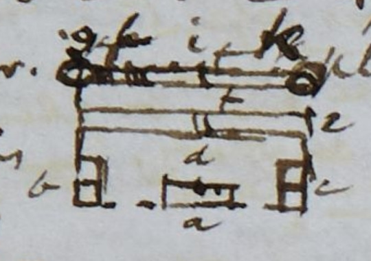
a Inn
b Mr. Bachmetieff’s house
c another corresponding house
d great court and parade yard
e line of barracks for the soldiers
f stable yard
g blacksmiths shop
h Cossack stable for about 12 horses
i large joiners shop and sort of coach house?
k post horse stable for 18 or 20 horses all one story buildings ascended by a step or two

View from a fort on the Russian side of the border. Forts like this one were common along the sides of the Georgian Military Road, which Anne and Ann are using in this stage.
1st village 1 lofty Tower 5 stories high and 2 lower Towers – All tapering square – About 6 of the squares (as at Kasbek) reckoned them at 6 families per square but they are all 2 stories high, and there are generally 6 on one floor or at least 4 families in these Sacles (Sacle signifies house in the language of the people) say 50 families in this village (but there are more?), and reckon 50 families = 200 souls just after this village that was high above us, Crocuses along our road purple and white 1st time and a thorny low, whitish little shrub covering the bottom of the Defile (Zizyphus? No! What is it?)
At 3 1/4 at the fourche a fine ravine left (saw no traces of the new road George mentioned) and a few coarse grass thatched stone huts, and enter our prong 2d.[2nd] of the fork, right, at 3 1/4 – At 3 20/’’ another fortification-like village (right) on the steep perpendicular rock, with 2 or 3 square Towers but low ones, and a little white line of mountain streamlet (misseau) tumbling down from the high summits close on this side the village – The 1st of these misseaux so common in the Alps and Pyrenees that we have seen here and on pinnacle of rock above the 2d.[2nd] village another village – Several square dry walled flat roofed stone houses along the flat bottom about a verst 3d.[3rd] wide good road –
At 3 25/’’ the village on pinnacle of rock above the 2d.[2nd] village – 2 more rock-seated picturesque villages in sight ahead of us the nearest with high tapering chimney like Tower 4th little Towerless village or hamlet left on the plaine rather in the glen defile to the left – At 3 33/’’ descend upon little wood bridge over little rapidy streamlet – 4 Ossete women on the bridge in picturesque costume mouths covered with dirty white handkerchiefs –
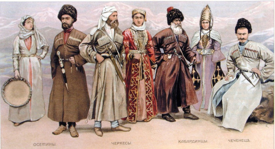
Traditional costumes of the people of the North Caucasus. Ossetian costumes are first from the left.
Another little village or 5th hamlet beyond the last and a peep at still another on the mountain side above the 5th village still farther in the the glen to the left
6th
8th the tall chimney-tower fortification old castle like village (vide line 7 above) on steep rocky projection high above us, left – The tall Tower 10 to 15 yards high – Narrows one half – The base seemed about 4 yards the top about 2 yards wide – One of the Towers at Kasbek seemed to narrow (to diminish) 1 yard in 5 yards of height – I could not see it quite from the bottom – The base might be 5 yards wide? –
Steep descent and drag now at 3 40/’’ down into glen (ravine) with little stream and wood bridge just below the chimney Towered village or Ossetine Town this tall small Tower seen from far in all directions – Little Tower on high rock on the other side of us opposite village no.[number] 8 – This pass has been well fortified in ancient times – The tall Tower of no.[number] 8 walled with lime – Looks a large old fortified place towards the South, out works a good way along the ridge that stretches (towards the South) up to the high mountain – The rock quite perpendicular towards our road – 2 great caves in the hill side joining part of the ridge strewed without works, more walling –
Ruined Tower &c. – Very picturesque – A little beyond us – 9 and 10 on the other side the deep ravine of river, at 3 55/’’ 2 villages on high ridge at a little distance apart one beyond and above the other – There must be plenty of common juniper near tho’ not seen by us for here we passed a Drovne on wheels loaded with it –
Astonishing the no.[number] of villages on the high steep rocks, and ridges, and bits of platforms under the high mountains – 11 another little village at 4, on the same ridge, on high point of rock above the 2 last villages there must be a little high valley between this ridge and the high mountains –
And now at 4 Terek 200 ft.[feet] in steep ravine close below us (right) – No guard – We might easily slip off the side of the narrow road into the river, a blueish, whitish, rapidy, 8 or 10 yards broad stream – Here, red, perpendicular schistose, irony? coloured mountain on the other side (left bank) of Terek, and on our left, always singularly rough, projectiony-pointed mountains –

I think there may be 2 or 3 more villages along the same ridge above named to the end of it but the mist is lowering now at 4 1/4 and all to lower than the top of this ridge will soon be hid on our right –
The bottom of our Defile becomes more strewed with big stones as well as little – The little at Kasbek and everywhere today gathered into large heaps to clear the champs which they sow with corn a small grain said one of the Ossetes at Kasbek – Blé sarrazin i.e. buck wheat? But he said it was all burnt up last summer –
12th village at 4 16/’’ with tapering not high square tower on the side of high mountain right – 13 village a little beyond and much lower down them the last on the same mountain side 14 ditto at the foot of the same mountain close upon stream? (rather far from us) an affluent of the Terek from deep glen or little valley from the North westward –
Little frozen small snow flying about now at 4 20/’’ as we toil up to higher ground a broad plateau above the deep ravine of river Terek – And in a minute or 2 steep pitch thro’ the snow narrow road along the brink of deep ravine going down to the Terek – The Courier wanted us to alight – He alighted and walked up –
15 at 4 1/2 (right) on mountain side village with square Tapering tower at a little distance above and beyond it but this village unlike all the rest has some sloping roofs tho’ looking fortress-like outside – All the villages of dark coloured stone hardly distinguishable from the rock –
High plateau of débris on each side Terek thro’ which it has formed the deep ravine – The mist covers 1/2 way down right, and now the ragged pointed summits left – We are perhaps 200 yards from foot of high mountains left and perhaps 300 or 400 yards from foot of ditto right – Some deep water courses down the mountains right but dry now –
4 40/’’ more snow on the road and mountains left much covered with snow, and very streaky right – At 4 50/’’ Kobi just in sight peeping from behind mountain head, right – At 5 steep descent from our plateau into the bottom down to the river divided into several little streams in the little basin like opening out of defile in which the dot near a is Kobi at 5 5/’’ cross little wood bridge over one of the streams still driving small snow –
d our road tomorrow
b castle
e Defile of the Terek 12 v.[versts] to its source said Colonel G-[Grauert] they say here one can go 15 v.[versts] along this defile and no farther –
c village
f ditto
16 old castle and at 5 10/’’ on rocky ridge (left) about in a line with Kobi, and at a little distance below this castle little fort-like village in and at the entrance of the little Defile to the East and about opposite another village at foot of high mountain right –
Enter Kobi at 5 1/4 thro’ little street of low flat-roofed shops about 8 on a side – Right side with little rude covered passage (portico) – At 5 17/’’ alight at our nice little stone? yellow washed Inn – This and 2 more such like buildings and the Ossetine Sâcles form the whole town of Kobi – No Krepost – The few Cossacks in low flat roofed huts near the Sacles – Delivered our 3 letters – The Prince of the place came – To be off very early – The Courier with empty carriages at 4 1/2 a.m. and we at 6 a.m. –
A-[Ann] and I went out – She sketched – I (with a soldier) went to the Sacles – Less good than those at Kasbek – 20 or 30 families or more – A neat little white washed stone church just before entering the village –
Tea over at 8 – ‘Tis now 11 5/’’ as I have just written so far – Fine day till the driving small snow in the afternoon (vide above) – Tonight they want us all to set off together – An officer and 25 men instead of 10 as the Prince said – 3 Traineaux – 2 for baggage instead of one! Our people frightened – I told George I should set off after the Courier and empty carriages – took off only pelerine and lay down in my gown and black stuff cloak at eleven and a half
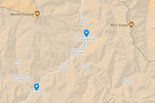
Anne’s and Ann’s route on this day.
[symbols in the margin of the page:] + 𐐥
[in the margin of the page:] Kasbeck
[in the margin of the page:] Leave Kasbek
[in the margin of the page:] Population of village
[in the margin of the page:] steep pitch
Page References: SH:7/ML/E/24/0077 and SH:7/ML/E/24/0078 and SH:7/ML/E/24/0079
3 notes
·
View notes
Photo


March 2022 Mangum Dental Hike-of-the-Month
Green Gulch Blue Hills Loop, Dewey Arizona
Distance: 10.6 miles
Difficulty: Moderate to difficult, due to rocky and steep terrain, elevation gain, and distance
Elevation Gain: 2,165 ft. (5240′ to 6831′)
Parking: Free parking at designated Green Gulch Trailhead, Prescott National Forest.
Directions: From Mangum Dental on Willow Creek Road, Prescott, Arizona, travel north on Willow Creek Road 5.2 miles and turn right on Pioneer Parkway. Stay on this road as it changes names (Pioneer Parkway, Hwy 89A, and Fain Road) for almost 15 miles then turn left on Highway 69 at the Maverick gas station. Travel 1.8 miles and turn right on Kachina Drive at the Blue Ridge Market. Pass the Dewey Post Office and follow the signs to the Green Gulch Trailhead. After 0.5 miles, turn left on S. Pony Pl and then a quick right on Henderson Road. Stay on this road for 3.3 miles. The road changes names to Newton Ave. but will dead-end at the Green Gulch Trailhead. The road is paved all the way to the dirt parking area.
Summary
This hike is in the Blue Hills Trail System in the Prescott National Forest, Bradshaw Ranger district, and is located between Highway 69 and Walker Road. These trails will connect Blue Hills Farms in Dewey to Lynx Lake and has a unique rugged beauty. The loop is made up of the Charcoal Gulch Trail (#9419), Salida Trail (#93), Prospectors Trail (#42), and Red Mountain Trail (#43). This area is welcome to hikers, horses, OHV, bicycles, and e-bikes. There are lots of colors to learn on this hike: Green Gulch, Blue Hills, Charcoal Gulch, and Red Mountain. Hiking in Green or Charcoal Gulch one might think of hiking in canyons or a gulch without much elevation, not so. The views were expansive and spectacular and the climbing is steep at times. Much of the trail is exposed with chaparral and pinyon-juniper forest. However, there are stretches of Ponderosa Pine, Gambel Oak, and shaded forest. The trails are wide in spots and deeply rutted in other areas.
The hike starts out on Charcoal Gulch Trail (#9419) after 1.0 the trail splits, stay left on #9419. Here the elevation increases as the trail rises above the Charcoal Gulch. Most of the trail from 1.0 mile to 4.0 mile is uphill with the exception of a steep downhill just before the Upper Charcoal Tank at the 3.0-mile mark. There is a refreshing Ponderosa Pine stand before the elevation increases again. The best view of Dewey-Humboldt is just before the junction with Salida Trail (#93) at the 4.0-mile mark. Turn right heading northwest on trail #93. Now, the stunning views are to the west. Admire Mount Union and Spruce Mountain as they stand tall in the distance. Hike along the ridge for a mile before the trail begins to descend. After a mile of steep downhill, that is washed out and rugged, there is the Quail Tank at about mile 6.5. Just after the tank, take the right fork onto Prospector Trail #42. In a half-mile, pass the third of five cow tanks. This one is named Bull Tank. At 7.5 miles this trail dead-ends into the Red Mountain Trail (#43). Turn right and head east then northeast. In a couple of hundred yards there is a wire gate next to the Trail Tank. Continue hiking and pass through two metal gates on your way toward the trailhead. Just after Bushy Tank around 9 1/4 miles, drop down to the #9419 and back to the trailhead.
This may not a favorite hiking spot, but it is an area that any hiker will want to explore and enjoy. On a Friday morning in January, there wasn’t another soul to be found. There are multiple trails in this area and the options are endless. The Prescott area has so many options to get outdoors and live free. Until next month, enjoy the beautiful land we are blessed to be in.
Mangum Dental is a general dental office that has been located in Prescott, Arizona since 1978. We specialize in customizing treatment to the patient's needs in a way that you can trust. Our tagline is “earning your trust with a smile.” Additional hikes can be found at www.mangumdental.com and click on the hike-of-the-month.
1 note
·
View note
Text
New Post has been published on Trekking in Pakistan
New Post has been published on http://bit.ly/2uOgr8h
Boibar

Duration 3 days Distance 27.4km Standard easy Season Mid-June-September Start/ Finish Jamalabad Zone and Permit open, no permit Public Transport no Summary The beautiful and rarely visited Boibar Valley is the route to Jurjur Khun-e-Sar, Tupodan, Parigar Sar and Qarũn Koh base camps, with Qarũn Pass offering exceptional views of the Hispar Muztagh.
Boibar is an east-west valley whose river descends from Qarũn Koh (7164m) to the Hunza River at Morkhun 10km south of Sost. Boibar is historically significant as the original Wakhi settlement in Gojal and the old route to Shimshal, and has spectacular old-growth juniper trees. Avgarch and Boibar are also names of places in the Wakhan Corridor, suggesting the original inhabitants may have come from Wakhan. Morkhun (2743m) receives more rain than other Gojal villages, as its name suggests (mor means ‘rain’; Khun, ‘house’). At the time of research, villagers were constructing a road to Avgarch with eventual plans to extend it to the Boibar huts.
PLANNING
Maps
The Swiss Foundation for Alpine Research 1:250, 000 orographical map Karakoram (Sheet 1) covers the trek. It labels Jamalabad as Jukulgar, Parigar Sar as Pregar, and the Boibar River at Murkhun. The glacier at the valley’s head labeled Murkhun is locally called Qarũn Koh. Maidun isn’t named, but it’s marked by a triangle.
Guides and Porters
Porters ask for a flat rate per stage, including payment for food rations and the clothing and equipment allowance. Hire a local person to show the way, learn about the area, and support the village’s economy.
GETTING TO/FROM THE TREK
Morkhun is halfway between Afiyatabad and Passu, so jump on any vehicle heading south from Afiyatabad or north from Passu. The short ride on NATCO buses and on vans or wagons. From Morkhun, north of the bridge and south of the Pakistan Army camp, follow the Jamalabad Link Rd half a Kilometre to its end. Jamalabad (2789m), named for the late Mir of Hunza, Mohammad Jamal Khan, lies above the Boibar River’s true right (north) bank.
THE TREK
Day 1 : Jamalabad to Boibar
3½-4½ hours, 7.7km, 716m ascent
Follow the trail east along the canal. A shrine to Shah Shams, marked by white flags, sits on the river’s south side. Reach the first footbridge in 30 minutes and cross to the true left bank. Watch for rock fall between Jamalabad and Avgarch and avoid this section of trail in rain or high winds. Continue along the river’s edge 30 minutes passing scattered rose bushes and the herb spandr to a clear side stream, which flows from Sangar, a scenic grassy ridge descending from Jurjur-Khun-e-Sar (6055m) to the south. (It takes five hours to reach Sangar from Morkhun, making it an eight-to nine-hour round trip).
Just beyond the stream pass Bandiletk. Here red markings on the rock are said to have been made by a bilas (evil spirit) who licked the rock after having eaten people. Villagers say it’s dangerous to travel here after dark. The area on both sides of the river, with its scattered artemisias, ephedras, and roses, is also known as Lalazar (beautiful place in Persian).
Continue 15 minutes to the second footbridge surrounded by tamarisks and a thorny shrub xakh and cross to the river’s true right bank. The trail forks immediately. Both trails lead to Avgarch, but people describe the right fork as dangerous. Take the left fork and follow the trail along the true right bank downstream, backtracking for a few minutes to the base of Yasin Band. Ascend a short 35-degree scree slope, and then a steep, narrow chimney with steps made out of juniper branches, to the terrace above. From this plateau are beautiful views south to Jurjur-Khun-e-Sar and east to Parigar Sar (6200m), a prominent rocky peak (sar) known as the rock (gar) where fairies (pari) dwell.
Continue 30 minutes along a canal at the base of a rocky rhubarb-dotted slope and through level fields and wildflowers to Avgarch (3200m). This large cultivated area was the first settlement of the Wakhi people living in the five villages between Sost and Morkhun who refer to themselves as Avgarchi. It has a mosque with unique wood carvings and two forts. One sits atop the central building, a reminder of the constant battles with Qirghiz people who also used the upper Hunza Valley until the 19th century. A lone giant juniper called Baltar Yarz is nearby. Legend says a boy, Baltar, would have died, but he sacrificed a cow near the juniper tree (yarz) and lived.
From Avgarch, continue up, then cross the river via a footbridge heading south-east to reach Boibar (3505m), a barren summer settlement 1½ hours from Avgarch. Boibar huts sit in a southern side valley, which has a small glacier. Above is the dramatic north face of Tupodan (6106m), whose name means ‘the sun-drenched mountain’.
Day 2 : Boibar to Maidun
2 hours, 6km, 495m ascent
Continue one hour to a cold spring called Xunza Kuk (Queen’s spring), then 30 minutes to Pariyar (the place loved by fairies). These overgrazed pastures are the upper limit of juniper. Many junipers have been cut, but some of those remaining are older than 1000 years. Maidun (4000m), 30 minutes farther, has good water and makes a fine base camp for exploring the upper Boibar Valley. The route to Tupodan Base Camp, used by the 1987 British expedition who were the first to summit Tupodan, heads south up the Tupodan Glacier from Maidun.
Side Trip : Qarũn Pass
4-5 hours, 11km, 873m ascent, 873m descent
The original, but now abandoned, route to Shimshal village followed the Boibar Valley, crossed Qarũn Pass, and descend 2100m of treacherous scree to reach the Shimshal River at Dut. A day trek to the top of the pass offers great views and a glimpse of how difficult access to Shimshal used to be. Legend has it that Mamu Singh, Shimshal’s founder, saw the meadows along the Lupgar Glacier from the pass and so decided to take his livestock there. Shimshalis say the pass is like the legendary miser, Qarũn, because no water is available on the arduous ascent from Dut to the pass, hence the name Qarũn Pass.
From Maidun, ascend 1½ hours past yellow rock outcrops to the pasture of Zardgarben (the base of the yellow rock) from where the pass cairn is visible. Continue, passing right of the Qarũn koh Glacier’s black moraine to the base of the pass (4500m). From this point, the routes to Qarũn Koh and Parigar Sar Base Camps head across the glacier east and north-east respectively. The route to the pass turns south, ascends a scree gully, and traverses to Qarũn Pass (4873m) in one hour. Lupgar Sar, Trivor and Destaghil Sar rise in front. Return from the Pass to Maidun.
Day 3 : Maidun to Jamalabad
4-5 hours, 13.7km, 1211m descent
Retrace steps Downvalley to Jamalabad.
0 notes
Text
Bozeman Ranches For Sale
Montana Tips
In 1971, Montana reclassified mountain lions as game pets as well as developed a controlled open season. This designation still stands.
" There.
are minimal states that allow mountain lion hunts, yet Montana can assert some of the very best locations for hunting these cats. Montana doesn't provide several moose tags, but they go away swiftly, and also the very same opts for the mountain goat. In truth, in 2019 a brand-new expense was presented to make Montana bighorn lamb, moose, mountain goat, and also grizzly birth become an as soon as in a lifetime harvest only. If the expense passes, it will certainly make these hunting opportunities evenmore desirable. This well-regarded Rocky Mountain state uses mule deer pursues, archery elk pursues, bear hunts, searching for antelopes on the levels, as well as amazing pursues for the age-old bighorn lamb. Combo searching licenses as well as application target dates notwithstanding a huge game search in Montana is the imagine a lifetime for numerous who hold the reasonable chase in the highest esteem as well as only desire.
to check out among our most beautiful states. Looking for a bit a lot more and even warm lunch for your hunting blind!.?. !? Follow my webpage, or on Facebook and Twitter. packing ... January 16, 2017 By Jack Ballard The journals of Meriwether Lewis, co-captain of the Lewis as well as Clark Expedition, include detailed summaries of the nationwhere they passed brand-new lands teaming with elk, deer as well as antelope. A few of Lewis.
The Story Of Montana Has Just Gone Global!
Montana Tips
' most poetic lines were booked for their surroundings in Montana where he created," As we handed down it appeared as if those scenes of visionary delight would certainly never ever have an end." This fervent praise for the landscape occurred not in the hills but on the eastern plains, along the financial institutions of the Missouri River. In addition to the sheer expanse of the landscape, the expedition was blown away with the plentiful wildlife in the location, especially those game pets that provided them with food: elk, mule as well as whitetail deer, bighorn lamb, bison, and pronghorn (antelope). Debt: Photo Courtesy Missouri River Nation The tough "breaks" along the Missouri include thick stands of ponderosa pines as well as junipers. Elk prosper in the middle of this cover. The plants and dirts of the region provide exceptional nourishment, enabling mature bulls to grow exceptionally large horns. Hunting these prize.
bulls with a rifle calls for a long-odds lottery license, but those that do attract have the possibility to take incredible animals. Archery hunting is likewise performed on a" draw-only "basis, however the probabilities are better. The due date for nonresident applications for archery and also rifle elk licenses is March 15. For even more details when and exactly how to use telephone call toll-free: 1-800-653-1319. Elk are located in various other locations, yet the majority of lie within a few miles of these prime places. As a basic regulation, elk density additionally enhances from eastern to west. For instance, less animals are located in the area around Fork Peck Dam rather than areas at the western end of the storage tank. Bountiful accessibility to public land is among the major.
destinations of elk hunting in Montana's Missouri River Country( there are more than a million acres of land open up to public searching in the Charles M. Russell National Wild animals Haven alone). Both state as well as federally handled public lands sprawl across thousands upon hundreds of acres of prime habitat. are additionally readily available throughout the area, supplying professional services to out-of-state hunters. Essentially, hunters need to be prepared to hunt at the very least a mile from lorry access, as elk normally keep a barrier of about that distance from motorized activity. Archers typically locate the most effective success in the amazing hours around daytime as well as sundown. Temperatures can be rather cozy in September and early October, providing elk inactive throughout the day, nonetheless, hunters seeking a diverse experience discover plenty to do at noontime. In addition to outstanding big-game hunting the Montana's Missouri River Country boasts robust populations of sharp-tailed and also sage complaint, as well as grey( Hungarian) partridges. Elk might be the marquee quarry psychological of numerous checking out hunters, but northeastern Montana likewise boasts outstanding opportunities for mule as well as whitetail deer. Mule deer are extensively dispersed throughout the region yet the majority of heavily concentrated in the Missouri Breaks and also adjacent grassy field habitat. The deep, bent coulees of the breaks supply superb cover, permitting some bucks.
youtube
to attain trophy condition. Mule deer can also be located on more open savanna and agricultural locations, particularly in position offering patches of bed linen cover. Credit Scores: Picture Politeness Missouri River Nation With such a variety in habitat and also simple accessibility to abundant public land, a mule deer quest can be as difficult as you intend to make it.
1 note
·
View note
Text
Why Buy A Ranch Close To Bozeman
How to Explain Montana to Your Boss
In 1971, Montana reclassified mountain lions as video game pets as well as established a controlled open season. This designation still stands.
" There.
are minimal states that allow mountain lion pursues, yet Montana can claim several of the most effective locations for hunting these cats. Montana does not offer lots of moose tags, but they vanish rapidly, and the same opts for the mountain goat. Actually, in 2019 a brand-new expense was presented to make Montana bighorn sheep, moose, hill goat, and also grizzly bear become an as soon as in a lifetime harvest just. If the costs passes, it will certainly make these searching chances evenmore preferable. This well-regarded Rocky Hill state provides mule deer hunts, archery elk pursues, bear pursues, searching for antelopes on the levels, and also incredible hunts for the age-old bighorn lamb. Combo searching licenses and also application target dates notwithstanding a huge game quest in Montana is the desire for a lifetime for several who hold the reasonable chase in the highest esteem and also just desire.
to see one of our most gorgeous states. Searching for a little bit more or perhaps warm lunch for your hunting blind!.?. !? Follow my website, or on Facebook and also Twitter. filling ... January 16, 2017 By Jack Ballard The journals of Meriwether Lewis, co-captain of the Lewis and Clark Expedition, contain comprehensive descriptions of the countrywhereby they passed colonies teaming with elk, deer and antelope. A few of Lewis.
Can Montana Really Help

Latest News About Montana
' most poetic lines were reserved for their environments in Montana where he wrote," As we handed down it seemed as if those scenes of visionary glamour would certainly never have an end." This impassioned appreciation for the landscape occurred not in the mountains however on the eastern levels, along the banks of the Missouri River. Along with the sheer stretch of the landscape, the expedition was blown away with the abundant wildlife in the area, specifically those game pets that supplied them with food: elk, burro and whitetail deer, bighorn sheep, bison, and also pronghorn (antelope). Credit Report: Photo Courtesy Missouri River Nation The sturdy "breaks" along the Missouri contain dense stands of ponderosa pines as well as junipers. Elk flourish in the middle of this cover. The plants and also soils of the area offer exceptional nutrition, permitting fully grown bulls to grow extremely big antlers. Pursuing these prize.
bulls with a rifle calls for a long-odds lotto license, yet those that do draw have the chance to take impressive animals. Archery hunting is likewise performed on a" draw-only "basis, however the odds are better. The deadline for nonresident applications for archery as well as rifle elk licenses is March 15. For additional information when as well as how to apply telephone call toll-free: 1-800-653-1319. Elk are discovered in other locations, however the majority of are situated within a few miles of these prime areas. As a general policy, elk thickness additionally raises from eastern to west. For instance, less pets are located in the area around Fork Peck Dam rather than areas at the western end of the storage tank. Bountiful access to public land is just one of the major.
tourist attractions of elk searching in Montana's Missouri River Nation( there are greater than a million acres of land available to public hunting in the Charles M. Russell National Wild animals Sanctuary alone). Both state as well as government managed public lands sprawl throughout thousands upon thousands of acres of prime habitat. are also offered throughout the region, offering specialist solutions to out-of-state seekers. For the many part, seekers should be prepared to quest at the very least a mile from lorry accessibility, as elk usually keep a buffer of about that range from mechanized task. Archers generally discover the most effective success in the great hrs around daytime and sundown. Temperature levels can be fairly warm in September as well as very early October, rendering elk inactive throughout the day, however, seekers seeking a varied experience discover plenty to do at noontime. In addition to phenomenal big-game hunting the Montana's Missouri River Country flaunts durable populations of sharp-tailed and sage grouch, as well as gray( Hungarian) partridges. Elk may be the marquee quarry in the mind of lots of seeing hunters, however northeastern Montana likewise flaunts outstanding opportunities for mule as well as whitetail deer. Mule deer are widely dispersed throughout the area but the majority of greatly concentrated in the Missouri Breaks as well as surrounding prairie environment. The deep, contorted coulees of the breaks give fantastic cover, permitting some bucks.
youtube
to attain prize condition. Mule deer can also be discovered on even more open meadow as well as agricultural locations, particularly in areas supplying patches of bed linen cover. Credit History: Image Politeness Missouri River Nation With such a range in habitat and also easy accessibility to abundant public land, a mule deer search can be as challenging as you intend to make it.
1 note
·
View note
Text
notes from the field
I live eight days at a time without a glass mirror. For any woman who has dealt with her fair share of confidence issues, you may understand the mixed bag that this is, this dreadful gift. I am learning to ease into my freedom with more and more welcome.
At work in the woods, in the company of my co-staff, my students, and the living world, I have a constant reflection. Standing close to a smelly teenager, I know I smell the same. Watching a boy eat his pot full of rice, I can imagine myself digging into mine with the same vigor. I sit around the fire pit immersed in my paperwork and look up, catching my breath because my co-staff’s face is caught in a golden glow and her hair alight in the setting sun, and am reminded that I’m caught in the same light, our beauty enhanced by the beauty around us.
I watch the desert grasses bend under the burden of the snow, resting contentedly in the weighty wait of the winter. The Utah and Rocky Mountain Junipers stretch out their arms to catch the snow while the Pinion Pines are more apt to let it pass through its needles. If I’m lucky I see the slender Quaking Aspen wear it like a mantle, regal, like it was made for winter weather. The Wawa Mountains stand guard around us who live in Pine Valley, snowcapped and indifferent to our shiverings and shufflings through deep snow. What are those things in my life that go about their business of being for their own selves, and make my life precious because they are?
I watch as tracks appear in the snow overnight as if made by an invisible, mysterious creature, but it is only the common rodent, sneaky and quick, or the American coyote who would rather be heard than seen. Once, we cross over mountain lion tracks as we trek east into a part of the field I’ve never ventured before. On a hike to a ghost town I watch a bird hop across the new snow, its feather-light and forked tracks barely making an impression. By the time I return, the evidence of its existence has melted. I am reminded of the hidden life. Of failed efforts. Of the ways we live our lives in the dark for fear that we are insubstantial.
I am reflected in the smile on the face of a student as she greets me, excited to see me again. I see myself in the angry eyes of one who thinks my standards too high, who wants someone to blame for the heavy hurt she carries alone. I see who I am when the stress and fear turn my voice harsh, and a child cowers. I am reborn when I listen deeply and see the same child unfold her heart before me.
I walk first in the line and carve out a path in the snow for a group of teenage boys who brag about their strength and resilience, who are afraid of their soft places and fears. The snow scares me, this deadly lightness, and I press on because they are behind me. I look down at the tracks I’m making, wondering when they’ll be covered again. I look behind me to check on the line of bundled figures carrying wood stacks and dromedaries filled to the brim because we’ve grown tired of constant wood-runs to melt the snow, we’ve tired of the constant struggle to stay warm and dry. The tracks I make are good enough for now, no matter when they will be covered again. I press on.
As I make myself, the whole world is offering me feedback, invites me into my deepest being. I who have ears to hear and eyes to see, I am listening, I am watching. I see myself reflected in the thousands of mirrors – human faces, juniper sprigs, unblemished snow, eternal mountains, singing coyotes, untamable mustangs, aching hearts, golden sunsets – and count myself fortunate. Grateful. More precious and whole because of this work in the world.
An infinite feast of the heart lies before me, and I see myself in it – imperfect on my own and so damn perfect as I blend into the world, in my place, here, now.
I see myself. Thank you.
0 notes
Text
New Post has been published on Trekking in Pakistan
New Post has been published on http://bit.ly/2uOgr8h
Boibar

Duration 3 days Distance 27.4km Standard easy Season Mid-June-September Start/ Finish Jamalabad Zone and Permit open, no permit Public Transport no Summary The beautiful and rarely visited Boibar Valley is the route to Jurjur Khun-e-Sar, Tupodan, Parigar Sar and Qarũn Koh base camps, with Qarũn Pass offering exceptional views of the Hispar Muztagh.
Boibar is an east-west valley whose river descends from Qarũn Koh (7164m) to the Hunza River at Morkhun 10km south of Sost. Boibar is historically significant as the original Wakhi settlement in Gojal and the old route to Shimshal, and has spectacular old-growth juniper trees. Avgarch and Boibar are also names of places in the Wakhan Corridor, suggesting the original inhabitants may have come from Wakhan. Morkhun (2743m) receives more rain than other Gojal villages, as its name suggests (mor means ‘rain’; Khun, ‘house’). At the time of research, villagers were constructing a road to Avgarch with eventual plans to extend it to the Boibar huts.
PLANNING
Maps
The Swiss Foundation for Alpine Research 1:250, 000 orographical map Karakoram (Sheet 1) covers the trek. It labels Jamalabad as Jukulgar, Parigar Sar as Pregar, and the Boibar River at Murkhun. The glacier at the valley’s head labeled Murkhun is locally called Qarũn Koh. Maidun isn’t named, but it’s marked by a triangle.
Guides and Porters
Porters ask for a flat rate per stage, including payment for food rations and the clothing and equipment allowance. Hire a local person to show the way, learn about the area, and support the village’s economy.
GETTING TO/FROM THE TREK
Morkhun is halfway between Afiyatabad and Passu, so jump on any vehicle heading south from Afiyatabad or north from Passu. The short ride on NATCO buses and on vans or wagons. From Morkhun, north of the bridge and south of the Pakistan Army camp, follow the Jamalabad Link Rd half a Kilometre to its end. Jamalabad (2789m), named for the late Mir of Hunza, Mohammad Jamal Khan, lies above the Boibar River’s true right (north) bank.
THE TREK
Day 1 : Jamalabad to Boibar
3½-4½ hours, 7.7km, 716m ascent
Follow the trail east along the canal. A shrine to Shah Shams, marked by white flags, sits on the river’s south side. Reach the first footbridge in 30 minutes and cross to the true left bank. Watch for rock fall between Jamalabad and Avgarch and avoid this section of trail in rain or high winds. Continue along the river’s edge 30 minutes passing scattered rose bushes and the herb spandr to a clear side stream, which flows from Sangar, a scenic grassy ridge descending from Jurjur-Khun-e-Sar (6055m) to the south. (It takes five hours to reach Sangar from Morkhun, making it an eight-to nine-hour round trip).
Just beyond the stream pass Bandiletk. Here red markings on the rock are said to have been made by a bilas (evil spirit) who licked the rock after having eaten people. Villagers say it’s dangerous to travel here after dark. The area on both sides of the river, with its scattered artemisias, ephedras, and roses, is also known as Lalazar (beautiful place in Persian).
Continue 15 minutes to the second footbridge surrounded by tamarisks and a thorny shrub xakh and cross to the river’s true right bank. The trail forks immediately. Both trails lead to Avgarch, but people describe the right fork as dangerous. Take the left fork and follow the trail along the true right bank downstream, backtracking for a few minutes to the base of Yasin Band. Ascend a short 35-degree scree slope, and then a steep, narrow chimney with steps made out of juniper branches, to the terrace above. From this plateau are beautiful views south to Jurjur-Khun-e-Sar and east to Parigar Sar (6200m), a prominent rocky peak (sar) known as the rock (gar) where fairies (pari) dwell.
Continue 30 minutes along a canal at the base of a rocky rhubarb-dotted slope and through level fields and wildflowers to Avgarch (3200m). This large cultivated area was the first settlement of the Wakhi people living in the five villages between Sost and Morkhun who refer to themselves as Avgarchi. It has a mosque with unique wood carvings and two forts. One sits atop the central building, a reminder of the constant battles with Qirghiz people who also used the upper Hunza Valley until the 19th century. A lone giant juniper called Baltar Yarz is nearby. Legend says a boy, Baltar, would have died, but he sacrificed a cow near the juniper tree (yarz) and lived.
From Avgarch, continue up, then cross the river via a footbridge heading south-east to reach Boibar (3505m), a barren summer settlement 1½ hours from Avgarch. Boibar huts sit in a southern side valley, which has a small glacier. Above is the dramatic north face of Tupodan (6106m), whose name means ‘the sun-drenched mountain’.
Day 2 : Boibar to Maidun
2 hours, 6km, 495m ascent
Continue one hour to a cold spring called Xunza Kuk (Queen’s spring), then 30 minutes to Pariyar (the place loved by fairies). These overgrazed pastures are the upper limit of juniper. Many junipers have been cut, but some of those remaining are older than 1000 years. Maidun (4000m), 30 minutes farther, has good water and makes a fine base camp for exploring the upper Boibar Valley. The route to Tupodan Base Camp, used by the 1987 British expedition who were the first to summit Tupodan, heads south up the Tupodan Glacier from Maidun.
Side Trip : Qarũn Pass
4-5 hours, 11km, 873m ascent, 873m descent
The original, but now abandoned, route to Shimshal village followed the Boibar Valley, crossed Qarũn Pass, and descend 2100m of treacherous scree to reach the Shimshal River at Dut. A day trek to the top of the pass offers great views and a glimpse of how difficult access to Shimshal used to be. Legend has it that Mamu Singh, Shimshal’s founder, saw the meadows along the Lupgar Glacier from the pass and so decided to take his livestock there. Shimshalis say the pass is like the legendary miser, Qarũn, because no water is available on the arduous ascent from Dut to the pass, hence the name Qarũn Pass.
From Maidun, ascend 1½ hours past yellow rock outcrops to the pasture of Zardgarben (the base of the yellow rock) from where the pass cairn is visible. Continue, passing right of the Qarũn koh Glacier’s black moraine to the base of the pass (4500m). From this point, the routes to Qarũn Koh and Parigar Sar Base Camps head across the glacier east and north-east respectively. The route to the pass turns south, ascends a scree gully, and traverses to Qarũn Pass (4873m) in one hour. Lupgar Sar, Trivor and Destaghil Sar rise in front. Return from the Pass to Maidun.
Day 3 : Maidun to Jamalabad
4-5 hours, 13.7km, 1211m descent
Retrace steps Downvalley to Jamalabad.
0 notes
Text
New Post has been published on Trekking in Pakistan
New Post has been published on http://bit.ly/2TSnreL
Asumbar Haghost

Duration 4 days Distance 44. 7km Standard moderate Season June-September Start Asumbar Finish Dal Sandhi Zone and Permit open, no permit Public and Transport yes Summary This culturally and linguistically diverse trek through alpine meadows crosses a gentle pass with sweeping vistas.
Asumbar Haghost, a nonglaciated east-west pass, links Asumbar village in Iskhoman with Dal Sandhi in Yasin. The pass is occasionally called the Iskhoman Pass (not to be confused with the Punji Pass. Which is also sometimes called Iskhoman Pass). Asumbar Haghost is one of the easiest passes to cross anywhere in the Karakoram and the Hindu Kush. The trek is also one of the most linguistically diverse. Along the trail, Shina, Khowar, Wakhi, and Burushaski are spoken, not to mention Urdu.
This trek is usually combined with at least one other trek. The Pakora Pass trek often precedes it, and the Punji Pass or Thui An treks often follow it, depending on you’re heading back to Gilgit or towards Chitral.
Planning
Maps
The US AMS topographic maps Baltit (NJ 43-14) and Mastuj (NJ 43 -13) cover the trek. No settlements east of the pass are labeled.

Guides and Porters
The route is fairly obvious so a local guide isn’t necessary. Porters use donkeys to carry their loads. rate is per donkey for 5okg. A rate for a fully- loaded donkey equals the wages for two 25kg porter loads. If you have less than 50kg, try negotiating a lower rate.
When you combine this trek with the Punji Pass trek, hire porters for both passes from either Pakoa or Asumbar. That way, the porters end up in the Iskhoman Valley just one stage away from their homes, minimizing wapasi.
Stages
Stages are not universally fixed, but four stages seem appropriate. Trekkers who pay three stages may have problems because the distance is difficult for trekkers, porters, and donkeys to cover comfortably in three days (ie, three stages).
GETTING TO/FROM THE TREK
To the Start
Gilgit- Asumbar jeeps and depart from Wad- din Transport service on Gilgit’s Punial Rd. Alternatively, you can try to find a jeep from Gakuch or Chatorkhand to Asumbar. A daily NATCO bus From Gilgit to Chatorkhand (5½ hours), a half-day walk from the trailhead, departs from Gilgit’s Punial Rd at 11 am. Gilgit- Asumbar special hires.
When you precede this trek with the Pakora Pass trek, you can walk 3.4km between Pakora and Asumbar on the road in one hour. From Pakora, head north to the bridge over the Iskhoman River and Cross to its true right bank. The trailhead is at the bridge over the Asumbar Nala Along its true right bank
From the Finish
Dal Sandhi- Gilgit jeeps. Special hires. Alternatively, walk 4km south to Taus and take the daily NATCO bus to Gilgit.
When following this trek with the Punji Pass trek, you need to get from Dal Sandhi to Darkot. Jeeps come infrequently to Dal Sandhi, so to find one walk 4km south to Taus or 7km north to Barkulti (two hours). Barkulti- Darkot Jeeps and take two hours. Special Hires Barkulti- Darkot, Dal Sandhi- Darkot, and Yasin- Darkot. If you can’t find a vehicle, plan two days to walk 25km between Dal Sandhi and Darkot.
The Trek
Day 1 : Asumbar Haghost to Lower Charinj
4- 6 hours, 8.4km, 270m ascent
The lower Asumbar Valley can be very hot and dry in summer; carry water and enjoy the shady places along the river. From Asumbar village (2910m), climb steadily up the Asumbar Nala’s true right (south) bank passing fields and in one hour reach the first of four footbridges. Cross to the true left bank and in 15 minutes cross the second footbridge, an enormous boulder, back to the true right bank. Climb steeply 45 minutes passing cornfields to silty streams from the south. A Gujar‘s house with a large willow sits across the stream. Continue 15 minutes and cross the third footbridge to the true left bank. Springs along the trail here provide the only clear water until Charinji.
Ahead is a dark rock pile, 100m high, known as Shah Dheri (black rocks). Continue along the now- forested stream around Shah Dheri in 30 minutes. Back down-valley are good views of Pakora Gol. Reach the fourth footbridge in another 15 minutes and get the first views up the valley towards the pass, Golomir, 15 minutes farther, is an open and grassy, but rocky and shade less, field. In 30 minutes pass above Tokun Kuch, an inviting forest with flat, grassy areas along both banks of the river. Tokun Kuch means the place where grass grew up to the bottom of the horse’s saddle blanket (tokun). The only silty river water. Continue high above the true right bank 15 minutes to a beautiful chir pine forest called Charinj. Charinji is a great campsite with lots of levels, grassy fields, and a series of clear streams running through the forest. Gujars have conical huts here, but in midsummer, they’re usually vacant. This area is also called Lower Charinj (3180m) and Zokhine war by the Wakhi speakers who live father upvalley.
Day 2 : Lower Charinj to Upper Borta Bort
3¾ – 4 hours. 8km, 810m ascent
Continue through the dense stand of trees 15 minutes to the first of five side streams that flow in from the south. Ford this large stream and climb 30 minutes past a few huts high above the river to Upper Charinj. Continue past junipers and tall birches and pass above the tree line to reach Wakhikandeh. A year-round Wakhi settlement with three households. Just past the houses, cross a footbridge over the second side stream.
This large side valley leads south across a 4500m ridge where two routes diverge. One route crosses the Asumbar An (4800m) to Darmodar Gah. And the other descends the Daeen Gol to Daeen village in the Iskhoman Valley, across the river from Chatorkhand. Although it’s longer for them, Daeen villagers prefer walking along the road to Asumbar village and then up the Asumbar Valley to Charinj rather than crossing this steep pass. A few Gujar huts are across this large side stream. Reach a third stream and more Gujar settlements in 30 minutes. The trail begins a steady climb, contouring up the rocky hillside past scrub junipers, to emerge after one hour in a pasture. This is Borta Bort, an area that gets its name from the huge boulder visible upvalley. The pass is visible far ahead.
The trail begins a steady climb, contouring up the rocky hillside past scrub junipers, to emerge after one hour in a pasture. This is Borta Bort, an area that gets its name from the huge boulder visible upvalley. The pass is visible far ahead. Four houses also called Borta Bort, lie 15 minutes ahead, and are inhabited by one Isma’ ili household from Shonas and three Gujar households from Asumbar. Women here wear tall pillbox- style hats.
Continue, passing several large scree slopes and more huts on the river’s opposite side, and in 30 minutes come to a large alluvial fan and the fourth stream. A possible camp lies across this side stream, but a better campsite is 30 minutes ahead. Cross over a grassy Knoll, with huts below its west side (beware of dogs), and cross a silty glacial side stream via a footbridge. Climb through flower-filled meadows along clear, spring-fed streams. Camp below large boulders at Upper Borta Bort (3990m) and enjoy spectacular views to the east. The Hayal Pass, Shani (5887m), Twin peaks (5798m and 5700m) and distant Rakaposhi (7788m) is visible.
Day 3 : Upper Borta Bort to Mayur
5½ hours, 10.6km, 570m ascent, 930m descent
The trail continues through the boulder field 45 minutes to a broad grassland called Jinali (polo ground in Khowar), a possible, although less desirable, high camp. Porters prefer staying in huts near Borta Bort. Ahead are two low points (passes) on either side of a hill. The route goes over the northern low point. The southern one is steep on the west side, passes close to an icefall, and cannot be crossed by donkeys. Cross Jinali, fording a silty side stream, and follow the river’s north (right) fork past springs 45 minutes to the base of the hill leading to the pass.
Ascend over grass one hour to the gentle flower- carpeted Asumbar Haghost (4560m). Rakaposhi and Diran (7257m) peaks to the east and the peaks of the high Hindu Kush to the west are visible.
Snowy patches lie just below and west of the pass. Descend for one hour, following a clear willow-lined stream to meadows. Continue north (right) on a trail, skirting willows. Cross the clear side stream from Asumbar peak to the north, above its confluence with the milky main streams, and continue past small springs to the huts of Ji Shawaran (polo ground in Shina), two hours below the pass, which is visible from this spot.
Cross a footbridge to the river’s true left (south) bank, and head down valley. Cross a low rise with two cairns on it to a large unnamed pond, visible from the pass, 45 minutes from Ji Shawaran. The slightly green water is deep enough for a swim and this is a possible campsite. A better campsite is 45 minutes farther, through extensive junipers, at Mayur (3630m). Springs abound below the huts along the clear river from the south. This river is the route over Darmodar Haghost.
Day 4 : Mayur to Dal Sandhi
5½- 6 hours, 17.7km, 930m descent
The main trail follows the Asumbar River’s true left bank, although another trail goes along Its true bank through three areas cultivated by Burusho from Sandhi. In one hour, reach Gamas, a huge cultivated area bisected by a large side stream, high above the main river’s south bank. Below Gamas, cross a footbridge to the true right bank where the trail stays to Dal Sandhi. After 30 minutes reach the start of Haghost An. When villagers irrigated this land and brought it under cultivation, they changed its name from Chucho Ano Tok (in Khowar, Chucho means ‘dry place’; ano, the ‘top of’) to Haghost An. Burusho, however, refers to it as Bay Haghost.
At Haghost An’s west end, descend steeply to tall willows along the river, then continue more gradually down the valley on a good trail. Pass Bericho Batan, where low-status Bericho people used to live, and ford a clear side stream. Descend the broad valley to Dal Sandhi (2700m), 2½ hours from Haghost An. You can camp in a lovely village orchard.
0 notes
Text
New Post has been published on Trekking in Pakistan
New Post has been published on http://bit.ly/2EvPEnY
Batura Glacier
Duration 5 days Distance 64.6km Standard moderate Season June-October Start/Finish China Camp Zone and Permit open, no permit Public Transport yes Summary The classic trek along a glant Karakoram glacier passes beneath the peaks of the imposing Batura Wall and Batura Ice Floes with some of the Karakoram’s best mountain scenery.
Batura, the most accessible and fourth- longest Karakoram glaciers, stretches west from the KKH for 56km. The trek’s exceptional scenery includes 14 peaks higher than 7000m and huge Ice floes plummeting more than 4000m from the Batura Wall to the glacier. Most of the trek is through ablation valleys and along streams. With almost no steep segments, it affords gradual acclimatization and presents no major difficulties. Even the trek’s two glacier crossings are relatively easy. Trekkers also get a glimpse into the unique way of life of Passu villagers, who tend livestock in the summer pastures along the glacier’s north margin.
The alternative route along the glacier’s south margin and glacier crossing (see alternative Days 4-5) presents a more shaded and cooler alternative to trekking along its sunny north margin on hot July and August days. Trekkers with less time or those disinclined to undertake any glacier crossings can simply trek along the south margin to Maidun and return by the same route. This makes a pleasant three-to four-day trek, but doesn’t give any views of the Batura Wall or ice Floes.
PLANNING
What to Bring
Wakhi people are generous and traditionally share food with visitors, but it’s unrealistic to expect food from people in pasture settlements. The herders’ huts are private property and aren’t available for trekkers’ use. Respect the people and their property; bring your own food and shelter.
Maps
The Swiss Foundation for Alpine Research 1:250,000 orographical map Karakoram (Sheet 1) and Deutschen Alpenverein (DAV) 1:00,000 topographic map Hunza-Karakoram cover the trek. Other maps feature the Batura Glacier and surrounding peaks. In 1978, the Institute of Glaciology, Cryopedology and Desert Research, Academia Sinica, Lanchow, China published a 1:60,000 topographic The Map of the Batura Glacier (US$27), but it can be hard to find. Jerzy Wala published two orographical sketch maps (US$14) with text in English and Polish: the 1:100,000 Batura Wall in 1984; and the 1:125,000 Batura Mustagh in 1988.
Uzhokpirt, which isn’t marked on the Swiss map, is beneath the peak labeled Shanoz (3922m). The Werthum stream, which is labeled Wartom Nala, isn’t depicted accurately. The map shows it flowing directly into (ie, perpendicular to) the Batura Glacier at Shilmin, but it turns south-east from the side valley and parallels the glacier for 7.5km before flowing into it between kukhil and Fatima’ il Sheet. The Yukshgoz Glacier is labeled as Yoksugoz Ice Flow, and Shireen Maidan Glacier is labeled as Shelin Maidan. The DAV map does not show Werthum Nala, labels Uzhokpirt as Verzokpirt, and indicates a lake east of Yashpirt that doesn’t exist.
Guides and Porters
Trekkers often get lost trying to cross the glacier, so hiring someone is recommended. Additionally, government authorities insist that all trekkers going onto the glacier be accompanied by someone from Passu. Typically, porters are hired for the duration of a trek and aren’t released along the way. Porters may expect large trekking parties to buy a goat or sheep.
Stages
It’s nine stages total round trip from Passu: (1) Yunzben; (2) Uzhokpirt; (3) Yashpirt; (4) Kukhil; (4½) Guchesham; and (4½-9) 4½ stages to return via the same route. The traditional first stage began, literally, in Passu village. (This was before the KKH was built.) Today, it’s understood to mean starting from China Camp or Janabad to Yunzben. Unfortunately, this makes for a short stage, much to porters’ advantage. When you camp at Lupdur, it’s half a stage beyond Guchesham; it’s one stage between Kukhil and Lupdur. Despite the fact that most trekkers Only camp at Guchesham, porters often ask for five stages one way from Passu instead of 4½ stages, much to their advantage. Additionally, porters may ask for an extra stage when crossing the glacier anywhere other than between Yunzben and Uzhokpirt. Negotiate the exact stages before starting.
Getting To/From The Trek
From Passu (2400m) a tractor or jeep to China Camp (2430m), named for the Chinese road labourers who stayed here while building the KKH. It’s 15 minutes’ drive north on the KKH to China Camp, a green area on the KKH’s west side south of the bridge over the Batura Glacier’s outwash stream.
Starting from the Janabad trailhead (2430m) is 1.3km longer than from the China Camp trailhead, but you can easily walk there from all hotels and don’t have to pay for transport.
The Trek
The Trek description below crosses the glacier between Yunzben and Uzhokpirt. Two longer and more difficult glacier crossings are between Piyakh Sheet and Maidun (see Alternative Day), and between Kush Bel and Kirgus Washk.
Day 1 : China Camp to Uzhokpirt
5-6 hours, 11.5km, 645m ascent
Follow the canal upstream 10 minutes to its head along the true right bank of the Batura Glacier’s outwash stream. The trail ascends along the lateral moraine, passing a cairn that marks the junction with the trail from Janabad, and in 45 minutes to one hour reaches a high point. Continue through a dusty ablation valley 20 minutes, then pass through a wooden doorway past scattered rose bushes to reach Yunzben (2880m, at the base of Yunz Valley) in 10 minutes. The hut here is called Summer House in memory of the late Summer Beg, the father of Passu guides Sanjar Beg and Safdar Hussain. Yunzben is a large level camp site in a starkly dry and dusty area. Water comes from moraine pools.
The shortest and most frequently used route across the Batura Glacier, preferred by Passu People both going to and coming from the pastures, begins a few minutes beyond Yunzben. Bits of dung and small cairns faintly mark the convoluted 2km route across the glacier (much of it across talus), which takes one to 1½ hours. Aim for the yellow rock face on the glacier’s far side with a prominent white streak on its east (right) edge separating it from a black rock face.
Near the glacier’s north margin, beneath the yellow rock face, turn north-west and continue up the unshaded narrow lateral moraine 1½ to two hours to another wooden doorway across the trail. As the first juniper appears, continue 30 to 45 minutes to a sizable silty lake. Follow the trail along its north shore and a few minutes beyond its west shore to Uzhokpirt (3075m), named for a triangular-shaped millstone (uzhok) once used here. The hut here was built in memory of Ali Dad, son of Passu guide Hunar Beg, who died in 1999. Mature willows and junipers offer ample shade, welcoming trekkers to pitch their tents and relax. A stream provides water, but by August it’s dry and water comes from the lake.
Alternative Start : Janabad to Uzhokpirt
5-6 hours, 13.1km, 645m ascent
The Janabad trailheads is on the KKH’s west side, where an old rectangular sign (between a large hotel under construction at the time of research and Passu Tourist Lodge) reads’ AKRSP Passu orchard- Funded by SWAP’. Trekkers staying at the Passu Tourist Lodge can shorten this day’s trek by 1.3km (making it 11.8km) by simply walking out the back of the property, up the hill and 10 minutes across the upper Janabad plateau to join this alternative trail at the base of the scree slope.
From the sign at the KKH, take the obvious trail past some ruined buildings 15 minutes to the base of a scree slope. Above the slope in white-painted rocks are the words ‘Long Live Pakistan’. Ascend a stable trail 15 minutes to the top of the scree slope. The trail crosses a large level, boulder-dotted plateau between Janabad and the Batura Glacier. Continue 20 minutes past numerous small livestock shelters adjacent to boulders. Head up past a rocky outcrop, then contour 10 minutes across a slope to a cairn-marked junction. Take the left fork up to the top of the lateral moraine, also marked by a cairn, offering the first views of the Batura Glacier. Descend a few minutes to meet the main trail between China Camp and Yunzben. Turn left and continue an hour to Yunzben.
See Day 1 (p) for the description between Yunzben and Uzhokpirt.
Kũch: The Annual Livestock
Migration
All Wakhi villages depend upon livestock. To maintain their sheep, goats and yaks, villagers move their herds to distant upland pastures as the summer progresses and return to their villages in late autumn. The migratory until of livestock tended by village women and children is referred to as the Kũch. Kũch is a Persian word meaning ‘migration,’ and Kũch are people who do this work. Although most villages have only a single Kũch, Shimshal village (see p) has several that got to different pastures.
Women milk the livestock morning and evening in large stone-walled pens near their huts. During the day, when young women and children take the livestock out to graze, the older women are busy in their huts turning milk into yogurt, butter and cheese, much of which is stored to eat during winter. This division of labour contrasts with that of Hunza where tending livestock and making butter is men’s work. Although all Wakhi visit the summer pastures, men recognize it as the women’s zone. These flower-filled grasslands with sparkling streams beneath snowy mountains are more than just a pleasant place for the Wakhi. They’re places of renewal and contentment, perhaps the main source of their well-being.
The return of the Kũch to the village in mid-October is a time of reunion and celebration in all Wakhi villages. After the return of the Kũch to the village, livestock are then tended by Shpũn, a small group of men who take the livestock to low-elevation winter pastures. In mid-May, the Shpũn turn the livestock back over to the community and the annual cycle begins again.
Day 2 : Uzhokpirt to Yashpirt
2-3 hours, 5.1km, 227m ascent
The easy trail between Uzhokpirt and Yashpirt meanders through pretty ablation valleys, amid substantial willows, wild roses, tamarisks and junipers. The first impressive views of the upper Batura Glacier and Batura First Ice Floe are 45 minutes beyond Uzhokpirt at Kush Bel. (Kush Bel is also an alternative place to cross the glacier to Kirgus Washk on its south margin). The place was named by a man who grabbed the tails of two oxen (bel in Urdu) in order to ford a water channel that was once here (and is now dry).
Forty-five minutes beyond Kush Bel is Yinj Gar Dur Gush (mouth of the narrow rocky valley) where an inviting clear stream flows from a cleft in the rock face to the north. Cross the stream and contour gradually up the juniper-dotted hill directly ahead 15 to 30 minutes to Yashpirt (3302m). In Wakhi, yash means ‘horse’; pirt, a ‘slopping meadow’. The huts and pastures, surrounded by a juniper forest, have spectacular views of the Batura First Ice Floe. Passu women tend herds of yaks, sheep and goats here until 25 July when they typically move to Guchesham. Camp east of, and away from, the huts, rather than between or near huts, to respect the residents’ privacy. Water flows from a small stream trickling through the pasture; its source is a few minutes’ walk through the forest above the pasture.
Passu people typically walk between Passu and Yashpirt in one day. Fit and acclimatized trekkers can reach Yashpirt in seven hours, but it’s too far for most trekkers to tackle in a day.
Day 3 : Yashpirt to Guchesham
5-6 hours, 15.7km, 328m ascent
Descend west past large junipers to the alluvial plain in the ablation valley. Follow the east trail north-west, through a lovely series of small ablation valleys, amid abundant junipers, willows and birches. An hour from Yashpirt, pass an old distinctive millstone, which was used until the late 1970s when barley was cultivated at Yashpirt and the primary summer pasture was Fatima’ il Sheet. Occasional willows line the trail along a meandering stream. In 15 minutes, reach Piyakh Sheet (3345m) where a strange stand of turugokh, a kind of poplar, grows. The terrain opens onto a broad alluvial fan called Fatima’ il Sheet (3402m). A side stream, Fatima’ il stream, flows across the fan as the trail continues north-west with the Batura First Ice Floe in Full view. The picturesque, yet largely unused Fatima’ il huts are at the plain’s west end, nestled against an Eolian fluted cliff, 30 minutes from Piyakh Sheet.
Continue up the ablation valley, passing through a wooden doorway, and reach the confluence of the good-sized Werthum Nala and the Batura Glacier 30 minutes from the Fatima’ il huts. Werthum Nala, the stream draining the Werthum Valley, parallels the Batura Glacier for 7.5km before disappearing dramatically under the Batura Glacier here. Ford the stream just above the confluence and continue along its true right (south) bank one hour to Kukhil (springside sheep pen) where a wooden footbridge leads to the hillside huts and livestock pens. Camp sites at Kukhil (3501m) are small and dusty. The best camp site is a gravelly spot along the stream’s true right (south) bank 100m below Kukhil.
From Kukhil, go along the true right (south) bank 1½ to two hours to another large alluvial fan called Shilmin (3627m), named after an abundant purple flower (shilm). It’s possible to camp in a level and slightly rocky area below (south of) the trail and above seasonal pools adequate for bathing. Werthum Nala leaves the Batura Glacier at Shilmin, making a 90-degree bend north-east. Cross the alluvial fan and descend to a ford of the Bostong stream. Climb onto a level terrace and, 30 minutes from Shilmin, reach Guchesham (gul means ‘flower’ in Persian; chesham, an ‘eye’ in Wakhi), with its 10 huts and livestock pen. A camp site is directly across the Bostong stream from Guchesham (3630m) on a flat plain at the base of a white scree slope, from where a spring emerges. The views of the Batura Wall from the moraine south of Guchesham are spectacular. In the distance to the east is Destaghil Sar.
Side Trip : Lupdur
6 hours, 5km, 240m ascent
The day trek to Lupdur (big meadow) offers great views of the Batura Second Ice Floe, the upper Batura Glacier and Kampir Dior (7168m). From Guchesham, stay along the Bostong stream’s true right (south) bank and go upvalley 30 minutes towards the obvious trail up the grassy slope. The trail eases after the first steep 100m. Follow the trail for one hour to Lupdur (3870m). Ibex and Himalayan snowcocks frequent these slopes. The views from here are worth the whole trek. Lupdur is bisected by a large ravine with a small pool at its bottom. Cross this ravine, continue through more pastures for better views of the Batura Second Ice Floe, and a view up the Yukshgoz (ibex grass) Glacier.
Side Trip : Kampir Dior and Pamiri Sar Base Camps
2-3 days
From Lupdur, cross to the Yukshgoz Glacier’s west side to another meadow called Poop Shikar Gah (grandfather’s hunting grounds). A guide is necessary to show the route across the glacier. Another day beyond are Kampir Dior and Pamiri Sar Base Camps. Alternatively, it’s possible to climb the peak above Poop Shikar Gah, marked as peak 5735m on the Swiss map, which is the culmination of a long ridge running east from Kuk Sar .
Days 4-5 : Guchesham to China Camp
2 days, 32.3km, 1200m descent
Retrace steps to China Camp, camping at Yashpirt or Uzhokpirt on Day 4.
Alternative Route : Guchesham to China Camp
Rather than returning on the same trail along the glacier’s north margin, it’s possible to cross the Batura Glacier higher up and return along its south margin.
Alternative Day 4 : Guchesham to Piyakh Sheet
4-5 hours, 12.4km, 285m descent
Retrace your steps to Piyakh Sheet. Camp here and get water from the Fatima’ il stream or, if it’s too silty, from the glacier. It’s necessary to spend the night at Piyakh Sheet from where the glacier crossing begins, because it’s too far to trek from Guchesham to Piyakh Sheet and cross the glacier on day.
Alternative Day 5 : Piyakh Sheet to Kirgus Washk
4-5 hours, 8km, 75m ascent, 420m descent
Turn south and cross moraine rubble five minutes, then descend the lateral moraine to reach the Batura Glacier in a few minutes. Crossings the glacier here isn’t easy. Toil up and down on steep moraine 45 minutes to one hour. Then reach white ice and go up and down and around crevasses 30 to 45 minutes, after which again come heaps of moraine that take another 30 to 45 minutes to navigate. Most of the rock is very loose and unstable. No trail exists, so a local guide is essential. After two to three hours on the glacier, emerge on its south margin at the five huts at Maidun (3420m), the highest pasture used by Hussaini villagers. Rising south of Maidun in is the prominent peak marked 6090m on the Swiss map.
Follow a trail down the ablation valley 10 minutes to a small stream on an alluvial fan. Twenty minutes beyond this, reach the two huts and livestock pen of Wudmull (3090m). Below Wudmull, leave the ablation valley and walk on a juniper-forested terrace well above the ablation valley. The trail grows faint as it crosses a rocky fan, which it ascends to avoid cliffs. Thirty to 45 minutes from Wudmull, a deep, narrow ravine slices through this terrace, just beyond the end of the nice juniper forest. Cross the ravine, which can be difficult in the summer when it holds a rushing stream, and descend five minutes to cross a small flat area at the base of a juniper-forested cliff. Descend gradually to a large alluvial fan covered by some snow pack, and cross it in 15 minutes. On its east side is a small stream beyond which is Kirgus Washk (in Wakhi, kirgus is a ‘Himalayan griffon’; washk, a broken stone wall’), with two huts and a livestock pen. Just before Kirgus Washk, near a small hillside and close to the stream, is a good flat, grassy camp site (3000m).
Alternative Day 6 : Kirgus Washk to China Camp
5-7 hours, 13km, 570m descent
The trail goes along the top of the southern and lower of two parallel moraines. Some 30 minutes below Kirgus Washk are two small blue Lakes, suitable for a dip. Skirt the hillside beyond these lakes, staying high above the ablation valley, passing through nice stands of juniper and wild rose. Below Kirgus Washk 1½ hours is a very large, light-coloured boulder with a cairn on top and a livestock pen underneath. This area, with its mixed grass and scree slopes, is called Landgarben (the base of the big rock). Thirty minutes below the boulder is a dry lake bed, and 15 minutes beyond that are the four huts and livestock pen at Mulungeen, where a steep trail from Patundas meets this trail. Just below Mulungeen are two helipads, built by the Pakistan Army. The trail bends slightly north-east as it descends the ablation valley, reaching Yunzben 45 minutes to one hour from Mulungeen. See Day 1 (p) for the description Between Yunzben and China Camp or Alternative Start (p) for the description between Yunzben and Janabad.
0 notes
Text
New Post has been published on Trekking in Pakistan
New Post has been published on http://bit.ly/2EqVxTg
Boibar
Duration 3 days Distance 27.4km Standard easy Season Mid-June-September Start/ Finish Jamalabad Zone and Permit open, no permit Public Transport no Summary The beautiful and rarely visited Boibar Valley is the route to Jurjur Khun-e-Sar, Tupodan, Parigar Sar and Qarũn Koh base camps, with Qarũn Pass offering exceptional views of the Hispar Muztagh.
Boibar is an east-west valley whose river descends from Qarũn Koh (7164m) to the Hunza River at Morkhun 10km south of Sost. Boibar is historically significant as the original Wakhi settlement in Gojal and the old route to Shimshal, and has spectacular old-growth juniper trees. Avgarch and Boibar are also names of places in the Wakhan Corridor, suggesting the original inhabitants may have come from Wakhan. Morkhun (2743m) receives more rain than other Gojal villages, as its name suggests (mor means ‘rain’; Khun, ‘house’). At the time of research, villagers were constructing a road to Avgarch with eventual plans to extend it to the Boibar huts.
PLANNING
Maps
The Swiss Foundation for Alpine Research 1:250, 000 orographical map Karakoram (Sheet 1) covers the trek. It labels Jamalabad as Jukulgar, Parigar Sar as Pregar, and the Boibar River at Murkhun. The glacier at the valley’s head labeled Murkhun is locally called Qarũn Koh. Maidun isn’t named, but it’s marked by a triangle.
Guides and Porters
Porters ask for a flat rate per stage, including payment for food rations and the clothing and equipment allowance. Hire a local person to show the way, learn about the area, and support the village’s economy.
GETTING TO/FROM THE TREK
Morkhun is halfway between Afiyatabad and Passu, so jump on any vehicle heading south from Afiyatabad or north from Passu. The short ride on NATCO buses and on vans or wagons. From Morkhun, north of the bridge and south of the Pakistan Army camp, follow the Jamalabad Link Rd half a Kilometre to its end. Jamalabad (2789m), named for the late Mir of Hunza, Mohammad Jamal Khan, lies above the Boibar River’s true right (north) bank.
THE TREK
Day 1 : Jamalabad to Boibar
3½-4½ hours, 7.7km, 716m ascent
Follow the trail east along the canal. A shrine to Shah Shams, marked by white flags, sits on the river’s south side. Reach the first footbridge in 30 minutes and cross to the true left bank. Watch for rock fall between Jamalabad and Avgarch and avoid this section of trail in rain or high winds. Continue along the river’s edge 30 minutes passing scattered rose bushes and the herb spandr to a clear side stream, which flows from Sangar, a scenic grassy ridge descending from Jurjur-Khun-e-Sar (6055m) to the south. (It takes five hours to reach Sangar from Morkhun, making it an eight-to nine-hour round trip).
Just beyond the stream pass Bandiletk. Here red markings on the rock are said to have been made by a bilas (evil spirit) who licked the rock after having eaten people. Villagers say it’s dangerous to travel here after dark. The area on both sides of the river, with its scattered artemisias, ephedras, and roses, is also known as Lalazar (beautiful place in Persian).
Continue 15 minutes to the second footbridge surrounded by tamarisks and a thorny shrub xakh and cross to the river’s true right bank. The trail forks immediately. Both trails lead to Avgarch, but people describe the right fork as dangerous. Take the left fork and follow the trail along the true right bank downstream, backtracking for a few minutes to the base of Yasin Band. Ascend a short 35-degree scree slope, and then a steep, narrow chimney with steps made out of juniper branches, to the terrace above. From this plateau are beautiful views south to Jurjur-Khun-e-Sar and east to Parigar Sar (6200m), a prominent rocky peak (sar) known as the rock (gar) where fairies (pari) dwell.
Continue 30 minutes along a canal at the base of a rocky rhubarb-dotted slope and through level fields and wildflowers to Avgarch (3200m). This large cultivated area was the first settlement of the Wakhi people living in the five villages between Sost and Morkhun who refer to themselves as Avgarchi. It has a mosque with unique wood carvings and two forts. One sits atop the central building, a reminder of the constant battles with Qirghiz people who also used the upper Hunza Valley until the 19th century. A lone giant juniper called Baltar Yarz is nearby. Legend says a boy, Baltar, would have died, but he sacrificed a cow near the juniper tree (yarz) and lived.
From Avgarch, continue up, then cross the river via a footbridge heading south-east to reach Boibar (3505m), a barren summer settlement 1½ hours from Avgarch. Boibar huts sit in a southern side valley, which has a small glacier. Above is the dramatic north face of Tupodan (6106m), whose name means ‘the sun-drenched mountain’.
Day 2 : Boibar to Maidun
2 hours, 6km, 495m ascent
Continue one hour to a cold spring called Xunza Kuk (Queen’s spring), then 30 minutes to Pariyar (the place loved by fairies). These overgrazed pastures are the upper limit of juniper. Many junipers have been cut, but some of those remaining are older than 1000 years. Maidun (4000m), 30 minutes farther, has good water and makes a fine base camp for exploring the upper Boibar Valley. The route to Tupodan Base Camp, used by the 1987 British expedition who were the first to summit Tupodan, heads south up the Tupodan Glacier from Maidun.
Side Trip : Qarũn Pass
4-5 hours, 11km, 873m ascent, 873m descent
The original, but now abandoned, route to Shimshal village followed the Boibar Valley, crossed Qarũn Pass, and descend 2100m of treacherous scree to reach the Shimshal River at Dut. A day trek to the top of the pass offers great views and a glimpse of how difficult access to Shimshal used to be. Legend has it that Mamu Singh, Shimshal’s founder, saw the meadows along the Lupgar Glacier from the pass and so decided to take his livestock there. Shimshalis say the pass is like the legendary miser, Qarũn, because no water is available on the arduous ascent from Dut to the pass, hence the name Qarũn Pass.
From Maidun, ascend 1½ hours past yellow rock outcrops to the pasture of Zardgarben (the base of the yellow rock) from where the pass cairn is visible. Continue, passing right of the Qarũn koh Glacier’s black moraine to the base of the pass (4500m). From this point, the routes to Qarũn Koh and Parigar Sar Base Camps head across the glacier east and north-east respectively. The route to the pass turns south, ascends a scree gully, and traverses to Qarũn Pass (4873m) in one hour. Lupgar Sar, Trivor and Destaghil Sar rise in front. Return from the Pass to Maidun.
Day 3 : Maidun to Jamalabad
4-5 hours, 13.7km, 1211m descent
Retrace steps Downvalley to Jamalabad.
0 notes
Text
New Post has been published on Trekking in Pakistan
New Post has been published on http://bit.ly/2soJ2TF
Rakaposhi Base Camp
Duration 3 days Distance 17.6km Standard easy Season June-September Start/Finish Minapin Zone and Permit open, no permit Public Transport yes Summary One of the shortest and easiest treks leading to a 7000m Karakoram peak base camp with sweeping views from Rakaposhi to Diran.
The Minapin Glacier sweeps down from the 16km- long fluted snowy ridge that connects Rakaposhi and Diran. Minapin village in Upper Nagyr sits along the Minapin River’s true right (east) bank above the confluence of the Minapin and Hunza rivers. The excellent short trek from Minapin village to Rakaposhi Base Camp, known locally as Tagaphari, is an ideal introduction to Karakoram trekking. Easily accessible from the KKH, the trek follows a good trail, offers sweeping vistas of Rakaposhi and Diran and is the standard route to the base camps of both peaks. Trekkers in top physical condition visit Tagaphari on a day hike from Minapin village, but most trekkers find that dividing the 1250m ascent into two days lets them enjoy the trek’s many pleasures.
PLANNING
Maps
The Deutscher Alpenverein (DAV) 1:50,000 topographic map Minapin (Rakaposhi Range) covers the trek.
Guides and Porters
Minapin has a porters’ union, which the village headman oversees. Porters, who transport loads on donkeys, ask for a flat per stage, including payment for food rations. Porters ask for the clothing and equipment allowance only when crossing the Minapin Glacier.
Stages
It’s four stages total round trip from Minapin: (1) Hapakun; (2) Tagaphari; and (3-4) two stages to return via the same route.
NEAREST VILLAGE
Minapin
Minapin is a very hospitable, yet traditional and conservative, village. Villagers ask that visitors dress in shalwar kameez and act respectfully. Women should be escorted in the village and on trek. The Burushaski name Minapin derives from compacted (pin) mud (resembling mina, the dry meal of pressed nuts, such as walnut, or apricots after their oil is extracted) that the glacier once deposited in the village.
Places to Stay and Eat
Minapin’s ground zero is (Diran Guest house). The gracious hosts, well- prepared food and peaceful grassy compound with orchard- shaded gardens distinguish this as one of the Northern Areas’ most tranquil places to stay. The dorm, and singles/doubles, all with hot running water. The camping fee. If you need a place to really rest and hang out for a few days between treks, this is it. It also rents tents, sleeping bags and Kitchen equipment, and sells limited tinned food, but it’s advisable to bring all trek food and supplies from Gilgit or Karimabad.
Getting There and Away
Public vans to Pisan and Minapin depart Gilgit’s Khazana (Bank) Rd near Golden Peak Inn, usually between 1 and 2pm. They’re unmarked and can be hard to find. The three- hour ride, plus per backpack or duffel bag. The 4km- long road to Minapin leaves the KKH at Pisan, just east of Ghulmet. From Pisan, it takes 45 minutes to walk to Minapin. The same public vans depart Pisan and Minapin daily for Gilgit at 6.15am.
When the Minapin vans are full, try Pisan and Miachar vans. The Pisan vans depart Gilgit before the Minapin vans, usually between noon and 1pm. The Miachar vans depart Gilgit about an hour after the Minapin vans. Gilgit- bound Miachar vans pass the Diran Guest House about 7am, but are usually already full.
No direct transport links Minapin with Karimabad, so just get to the KKH and jump on any passing vehicle. Karimabad- Minapin special hires.
GETTING TO/FROM THE TREK
See Getting There and Away, above.
The Trek
Day 1 : Minapin to Hapakun
3- 4 hours, 5.8km, 792m ascent
From Diran Guest House (2012m), follow the road two minutes east. Then turn south (right) onto a dirt lane and follow it five minutes to the canal along the village’s south end. Turn west (right) and follow the path along the canal 15 minutes towards the Minapin River. Walnut trees shade the path and provide a home for nesting orioles (maiun). The trail turns south into the canyon and crosses a footbridge (2103m) over the rushing torrent to the river’s true left bank after 10 minutes.
The trail rises 183m on switchbacks for 30 minutes, then eases off and enters an open, aromatic juniper forest. Continue along the broad, shaded trail, rising gradually in one to 1½ hours to the huts at Bang-i-das, along a clear stream that tumbles over a cascade at the head of this pleasant side valley. The trail follows the stream 30 minutes to the base of the waterfall, where it forks. The right fork, which crosses the stream over a footbridge, leads to Gutumerung (see Alternative Day 3,). Follow the smaller left fork and climb 90m in 15 minutes to the grassy, tiered meadow of Hapakun (2804m) bordered by stands of mature fir trees. The Burushaski name Hapakun is given to a place (Kun) within a day’s walk of a main village, which is defined as ‘close enough to carry a child’ (hapa).
Camping is free in the open meadow, with northern views of Hachindar and Maiun peaks above the Hunza River. Diran and Rakaposhi remain hidden from view. Ibex inhabit the steep cliffs to the east high above the Minapin Glacier. A small, sometimes silty stream flows near the herders’ huts at Hapakun, but a clear spring lies behind and five minutes below the huts. It costs camp on private land near the spring.
Day 2 : Hapakun to Tagaphari
2- 3 hours, 3km, 457m ascent
Crossing the canal between the two huts, the trail (the one perpendicular to the canal, not parallel to it) heads south, rising across rock- strewn open ground beyond Hapakun’s largest hut—for a minute or two- and then climbs immediately west up dusty switchbacks through fir forest for 15 minutes. The trail eases off and contours the rocky slope for 30 minutes to a verdant bowl where wildflowers and colourful songbirds thrive. Sweeping gently through the meadow, the trail enters scattered juniper stands and climbs switchbacks to the windy ridge top, where Diran, Rakaposhi and their interconnecting ice wall finally come into full view.
The trail thins and traverses a rocky cliff above the spectacularly broken Minapin Glacier 15 minutes to Tagaphari (3261m). Once a muddy (taga) lake (phari), as its Burushaski name indicates, it’s now a level pasture, where cows and oxen graze. A herders’ hut is next to the rocky hillside, with plenty of good grassy camp sites along the meandering stream. A small seasonal spring lies at the base of the rocky slope towards the head of this small valley. The lateral moraine above the valley is a fun place to watch avalanches crashing down from the ridge between Rakaposhi and Diran, and to catch the sunset on Diran. Rakaposhi itself is mostly hidden from view behind the obvious snow dome of Rakaposhi East (7010m).
Side Trip : Askoreshung
3 hours, 5.8km, 1319m ascent, 1319m descent
Askoreshung (askor means a ‘flower’; shung, a ‘narrow path’) is a view point (3780m) atop the second ridge west of Tagaphari from where the Batura, Shishpar and Ultar peaks above Hunza are visible. From Tagaphari, ascend steeply west to the first ridge (3650m), descend and cross the intervening Gutumerung stream, reaching the second ridge in two hours. Return to Tagaphari in one hour.
Side Trip : Diran Base Camp
7- 8 hours, 12km, 389m ascent, 389m descent
Diran Base Camp is locally known as Kacheli, a Burushaski word meaning ‘the best grazing grass’. Minapin and Miachar villagers share these birch- dotted pastures. The area, along the Minapin Glacier’s north- east margin, is similar to Tagaphari with good camp sites and a small spring nearby. Visiting Kacheli as a day hike from Tagaphari is a more strenuous, but less expensive, option than camping at Kacheli and paying porters for the two additional stages (one there, one back).
From Tagaphari, follow the crest of the lateral moraine south 20 to 30 minutes to the small cairn (3510m) marking the route onto the glacier. It takes three hours to cross the broad Minapin Glacier and reach Diran Base Camp (3650m). The unmarked route north- east across the glacier’s alternating bands of rock and ice near many seracs is difficult to follow and changeable, so take a local guide or porter who knows the way. Carry a rope for safety. Watch for marginal crevasses when exciting the glacier.
From Diran Base Camp, trekking south- east up the ablation valley towards the rocky bend (4040m) in the glacier brings you to the point where the route to camp l moves onto the glacier, close beneath Diran. Enjoy the view, but don’t continue onto the heavily crevassed glacier. Experienced climbers can attempt Pheker (5465m) from base Camp.
Side Trip : Kacheli Lake
3 hours, 8km, 300m ascent, 300m descent
It takes two hours to climb steeply to the small Kacheli Lake above Diran Base Camp, and half that to return.
Day 3 : Tagaphari to Minapin
3- 3½ hours, 8.8km, 1249m descent
Retrace your steps downvalley to Minapin via Hapakun.
Alternative Day 3 : Tagaphari to Minapin
4- 4½ hours, 8.4km, 389m ascent, 1638m descent
Ascend the ridge (3650m) immediately west of Tagaphari for sweeping views, and descend steeply to Gutumerung, a pasture (rung) in this deep (gutum) valley where sheep and goats graze. Follow the trail steeply downstream (north) until it passes the waterfall at the head of the Bang-i-das Valley and joins the trail between Hapakun and Minapin.
0 notes
Text
New Post has been published on Trekking in Pakistan
New Post has been published on http://bit.ly/2uG0TUi
Batura Glacier

Duration 5 days Distance 64.6km Standard moderate Season June-October Start/Finish China Camp Zone and Permit open, no permit Public Transport yes Summary The classic trek along a glant Karakoram glacier passes beneath the peaks of the imposing Batura Wall and Batura Ice Floes with some of the Karakoram’s best mountain scenery.
Batura, the most accessible and fourth- longest Karakoram glaciers, stretches west from the KKH for 56km. The trek’s exceptional scenery includes 14 peaks higher than 7000m and huge Ice floes plummeting more than 4000m from the Batura Wall to the glacier. Most of the trek is through ablation valleys and along streams. With almost no steep segments, it affords gradual acclimatization and presents no major difficulties. Even the trek’s two glacier crossings are relatively easy. Trekkers also get a glimpse into the unique way of life of Passu villagers, who tend livestock in the summer pastures along the glacier’s north margin.
The alternative route along the glacier’s south margin and glacier crossing (see alternative Days 4-5) presents a more shaded and cooler alternative to trekking along its sunny north margin on hot July and August days. Trekkers with less time or those disinclined to undertake any glacier crossings can simply trek along the south margin to Maidun and return by the same route. This makes a pleasant three-to four-day trek, but doesn’t give any views of the Batura Wall or ice Floes.
PLANNING
What to Bring
Wakhi people are generous and traditionally share food with visitors, but it’s unrealistic to expect food from people in pasture settlements. The herders’ huts are private property and aren’t available for trekkers’ use. Respect the people and their property; bring your own food and shelter.
Maps
The Swiss Foundation for Alpine Research 1:250,000 orographical map Karakoram (Sheet 1) and Deutschen Alpenverein (DAV) 1:00,000 topographic map Hunza-Karakoram cover the trek. Other maps feature the Batura Glacier and surrounding peaks. In 1978, the Institute of Glaciology, Cryopedology and Desert Research, Academia Sinica, Lanchow, China published a 1:60,000 topographic The Map of the Batura Glacier (US$27), but it can be hard to find. Jerzy Wala published two orographical sketch maps (US$14) with text in English and Polish: the 1:100,000 Batura Wall in 1984; and the 1:125,000 Batura Mustagh in 1988.
Uzhokpirt, which isn’t marked on the Swiss map, is beneath the peak labeled Shanoz (3922m). The Werthum stream, which is labeled Wartom Nala, isn’t depicted accurately. The map shows it flowing directly into (ie, perpendicular to) the Batura Glacier at Shilmin, but it turns south-east from the side valley and parallels the glacier for 7.5km before flowing into it between kukhil and Fatima’ il Sheet. The Yukshgoz Glacier is labeled as Yoksugoz Ice Flow, and Shireen Maidan Glacier is labeled as Shelin Maidan. The DAV map does not show Werthum Nala, labels Uzhokpirt as Verzokpirt, and indicates a lake east of Yashpirt that doesn’t exist.
Guides and Porters
Trekkers often get lost trying to cross the glacier, so hiring someone is recommended. Additionally, government authorities insist that all trekkers going onto the glacier be accompanied by someone from Passu. Typically, porters are hired for the duration of a trek and aren’t released along the way. Porters may expect large trekking parties to buy a goat or sheep.
Stages
It’s nine stages total round trip from Passu: (1) Yunzben; (2) Uzhokpirt; (3) Yashpirt; (4) Kukhil; (4½) Guchesham; and (4½-9) 4½ stages to return via the same route. The traditional first stage began, literally, in Passu village. (This was before the KKH was built.) Today, it’s understood to mean starting from China Camp or Janabad to Yunzben. Unfortunately, this makes for a short stage, much to porters’ advantage. When you camp at Lupdur, it’s half a stage beyond Guchesham; it’s one stage between Kukhil and Lupdur. Despite the fact that most trekkers Only camp at Guchesham, porters often ask for five stages one way from Passu instead of 4½ stages, much to their advantage. Additionally, porters may ask for an extra stage when crossing the glacier anywhere other than between Yunzben and Uzhokpirt. Negotiate the exact stages before starting.
Getting To/From The Trek
From Passu (2400m) a tractor or jeep to China Camp (2430m), named for the Chinese road labourers who stayed here while building the KKH. It’s 15 minutes’ drive north on the KKH to China Camp, a green area on the KKH’s west side south of the bridge over the Batura Glacier’s outwash stream.
Starting from the Janabad trailhead (2430m) is 1.3km longer than from the China Camp trailhead, but you can easily walk there from all hotels and don’t have to pay for transport.
The Trek
The Trek description below crosses the glacier between Yunzben and Uzhokpirt. Two longer and more difficult glacier crossings are between Piyakh Sheet and Maidun (see Alternative Day), and between Kush Bel and Kirgus Washk.
Day 1 : China Camp to Uzhokpirt
5-6 hours, 11.5km, 645m ascent
Follow the canal upstream 10 minutes to its head along the true right bank of the Batura Glacier’s outwash stream. The trail ascends along the lateral moraine, passing a cairn that marks the junction with the trail from Janabad, and in 45 minutes to one hour reaches a high point. Continue through a dusty ablation valley 20 minutes, then pass through a wooden doorway past scattered rose bushes to reach Yunzben (2880m, at the base of Yunz Valley) in 10 minutes. The hut here is called Summer House in memory of the late Summer Beg, the father of Passu guides Sanjar Beg and Safdar Hussain. Yunzben is a large level camp site in a starkly dry and dusty area. Water comes from moraine pools.
The shortest and most frequently used route across the Batura Glacier, preferred by Passu People both going to and coming from the pastures, begins a few minutes beyond Yunzben. Bits of dung and small cairns faintly mark the convoluted 2km route across the glacier (much of it across talus), which takes one to 1½ hours. Aim for the yellow rock face on the glacier’s far side with a prominent white streak on its east (right) edge separating it from a black rock face.
Near the glacier’s north margin, beneath the yellow rock face, turn north-west and continue up the unshaded narrow lateral moraine 1½ to two hours to another wooden doorway across the trail. As the first juniper appears, continue 30 to 45 minutes to a sizable silty lake. Follow the trail along its north shore and a few minutes beyond its west shore to Uzhokpirt (3075m), named for a triangular-shaped millstone (uzhok) once used here. The hut here was built in memory of Ali Dad, son of Passu guide Hunar Beg, who died in 1999. Mature willows and junipers offer ample shade, welcoming trekkers to pitch their tents and relax. A stream provides water, but by August it’s dry and water comes from the lake.
Alternative Start : Janabad to Uzhokpirt
5-6 hours, 13.1km, 645m ascent
The Janabad trailheads is on the KKH’s west side, where an old rectangular sign (between a large hotel under construction at the time of research and Passu Tourist Lodge) reads’ AKRSP Passu orchard- Funded by SWAP’. Trekkers staying at the Passu Tourist Lodge can shorten this day’s trek by 1.3km (making it 11.8km) by simply walking out the back of the property, up the hill and 10 minutes across the upper Janabad plateau to join this alternative trail at the base of the scree slope.
From the sign at the KKH, take the obvious trail past some ruined buildings 15 minutes to the base of a scree slope. Above the slope in white-painted rocks are the words ‘Long Live Pakistan’. Ascend a stable trail 15 minutes to the top of the scree slope. The trail crosses a large level, boulder-dotted plateau between Janabad and the Batura Glacier. Continue 20 minutes past numerous small livestock shelters adjacent to boulders. Head up past a rocky outcrop, then contour 10 minutes across a slope to a cairn-marked junction. Take the left fork up to the top of the lateral moraine, also marked by a cairn, offering the first views of the Batura Glacier. Descend a few minutes to meet the main trail between China Camp and Yunzben. Turn left and continue an hour to Yunzben.
See Day 1 above for the description between Yunzben and Uzhokpirt.
Kũch: The Annual Livestock
Migration
All Wakhi villages depend upon livestock. To maintain their sheep, goats and yaks, villagers move their herds to distant upland pastures as the summer progresses and return to their villages in late autumn. The migratory until of livestock tended by village women and children is referred to as the Kũch. Kũch is a Persian word meaning ‘migration,’ and Kũch are people who do this work. Although most villages have only a single Kũch, Shimshal village (see p) has several that got to different pastures.
Women milk the livestock morning and evening in large stone-walled pens near their huts. During the day, when young women and children take the livestock out to graze, the older women are busy in their huts turning milk into yogurt, butter and cheese, much of which is stored to eat during winter. This division of labour contrasts with that of Hunza where tending livestock and making butter is men’s work. Although all Wakhi visit the summer pastures, men recognize it as the women’s zone. These flower-filled grasslands with sparkling streams beneath snowy mountains are more than just a pleasant place for the Wakhi. They’re places of renewal and contentment, perhaps the main source of their well-being.
The return of the Kũch to the village in mid-October is a time of reunion and celebration in all Wakhi villages. After the return of the Kũch to the village, livestock are then tended by Shpũn, a small group of men who take the livestock to low-elevation winter pastures. In mid-May, the Shpũn turn the livestock back over to the community and the annual cycle begins again.
Day 2 : Uzhokpirt to Yashpirt
2-3 hours, 5.1km, 227m ascent
The easy trail between Uzhokpirt and Yashpirt meanders through pretty ablation valleys, amid substantial willows, wild roses, tamarisks and junipers. The first impressive views of the upper Batura Glacier and Batura First Ice Floe are 45 minutes beyond Uzhokpirt at Kush Bel. (Kush Bel is also an alternative place to cross the glacier to Kirgus Washk on its south margin). The place was named by a man who grabbed the tails of two oxen (bel in Urdu) in order to ford a water channel that was once here (and is now dry).
Forty-five minutes beyond Kush Bel is Yinj Gar Dur Gush (mouth of the narrow rocky valley) where an inviting clear stream flows from a cleft in the rock face to the north. Cross the stream and contour gradually up the juniper-dotted hill directly ahead 15 to 30 minutes to Yashpirt (3302m). In Wakhi, yash means ‘horse’; pirt, a ‘slopping meadow’. The huts and pastures, surrounded by a juniper forest, have spectacular views of the Batura First Ice Floe. Passu women tend herds of yaks, sheep and goats here until 25 July when they typically move to Guchesham. Camp east of, and away from, the huts, rather than between or near huts, to respect the residents’ privacy. Water flows from a small stream trickling through the pasture; its source is a few minutes’ walk through the forest above the pasture.
Passu people typically walk between Passu and Yashpirt in one day. Fit and acclimatized trekkers can reach Yashpirt in seven hours, but it’s too far for most trekkers to tackle in a day.
Day 3 : Yashpirt to Guchesham
5-6 hours, 15.7km, 328m ascent
Descend west past large junipers to the alluvial plain in the ablation valley. Follow the east trail north-west, through a lovely series of small ablation valleys, amid abundant junipers, willows and birches. An hour from Yashpirt, pass an old distinctive millstone, which was used until the late 1970s when barley was cultivated at Yashpirt and the primary summer pasture was Fatima’ il Sheet. Occasional willows line the trail along a meandering stream. In 15 minutes, reach Piyakh Sheet (3345m) where a strange stand of turugokh, a kind of poplar, grows. The terrain opens onto a broad alluvial fan called Fatima’ il Sheet (3402m). A side stream, Fatima’ il stream, flows across the fan as the trail continues north-west with the Batura First Ice Floe in Full view. The picturesque, yet largely unused Fatima’ il huts are at the plain’s west end, nestled against an Eolian fluted cliff, 30 minutes from Piyakh Sheet.
Continue up the ablation valley, passing through a wooden doorway, and reach the confluence of the good-sized Werthum Nala and the Batura Glacier 30 minutes from the Fatima’ il huts. Werthum Nala, the stream draining the Werthum Valley, parallels the Batura Glacier for 7.5km before disappearing dramatically under the Batura Glacier here. Ford the stream just above the confluence and continue along its true right (south) bank one hour to Kukhil (springside sheep pen) where a wooden footbridge leads to the hillside huts and livestock pens. Camp sites at Kukhil (3501m) are small and dusty. The best camp site is a gravelly spot along the stream’s true right (south) bank 100m below Kukhil.
From Kukhil, go along the true right (south) bank 1½ to two hours to another large alluvial fan called Shilmin (3627m), named after an abundant purple flower (shilm). It’s possible to camp in a level and slightly rocky area below (south of) the trail and above seasonal pools adequate for bathing. Werthum Nala leaves the Batura Glacier at Shilmin, making a 90-degree bend north-east. Cross the alluvial fan and descend to a ford of the Bostong stream. Climb onto a level terrace and, 30 minutes from Shilmin, reach Guchesham (gul means ‘flower’ in Persian; chesham, an ‘eye’ in Wakhi), with its 10 huts and livestock pen. A camp site is directly across the Bostong stream from Guchesham (3630m) on a flat plain at the base of a white scree slope, from where a spring emerges. The views of the Batura Wall from the moraine south of Guchesham are spectacular. In the distance to the east is Destaghil Sar.
Side Trip : Lupdur
6 hours, 5km, 240m ascent
The day trek to Lupdur (big meadow) offers great views of the Batura Second Ice Floe, the upper Batura Glacier and Kampir Dior (7168m). From Guchesham, stay along the Bostong stream’s true right (south) bank and go upvalley 30 minutes towards the obvious trail up the grassy slope. The trail eases after the first steep 100m. Follow the trail for one hour to Lupdur (3870m). Ibex and Himalayan snowcocks frequent these slopes. The views from here are worth the whole trek. Lupdur is bisected by a large ravine with a small pool at its bottom. Cross this ravine, continue through more pastures for better views of the Batura Second Ice Floe, and a view up the Yukshgoz (ibex grass) Glacier.
Side Trip : Kampir Dior and Pamiri Sar Base Camps
2-3 days
From Lupdur, cross to the Yukshgoz Glacier’s west side to another meadow called Poop Shikar Gah (grandfather’s hunting grounds). A guide is necessary to show the route across the glacier. Another day beyond are Kampir Dior and Pamiri Sar Base Camps. Alternatively, it’s possible to climb the peak above Poop Shikar Gah, marked as peak 5735m on the Swiss map, which is the culmination of a long ridge running east from Kuk Sar .
Days 4-5 : Guchesham to China Camp
2 days, 32.3km, 1200m descent
Retrace steps to China Camp, camping at Yashpirt or Uzhokpirt on Day 4.
Alternative Route : Guchesham to China Camp
Rather than returning on the same trail along the glacier’s north margin, it’s possible to cross the Batura Glacier higher up and return along its south margin.
Alternative Day 4 : Guchesham to Piyakh Sheet
4-5 hours, 12.4km, 285m descent
Retrace your steps to Piyakh Sheet. Camp here and get water from the Fatima’ il stream or, if it’s too silty, from the glacier. It’s necessary to spend the night at Piyakh Sheet from where the glacier crossing begins, because it’s too far to trek from Guchesham to Piyakh Sheet and cross the glacier on day.
Alternative Day 5 : Piyakh Sheet to Kirgus Washk
4-5 hours, 8km, 75m ascent, 420m descent
Turn south and cross moraine rubble five minutes, then descend the lateral moraine to reach the Batura Glacier in a few minutes. Crossings the glacier here isn’t easy. Toil up and down on steep moraine 45 minutes to one hour. Then reach white ice and go up and down and around crevasses 30 to 45 minutes, after which again come heaps of moraine that take another 30 to 45 minutes to navigate. Most of the rock is very loose and unstable. No trail exists, so a local guide is essential. After two to three hours on the glacier, emerge on its south margin at the five huts at Maidun (3420m), the highest pasture used by Hussaini villagers. Rising south of Maidun in is the prominent peak marked 6090m on the Swiss map.
Follow a trail down the ablation valley 10 minutes to a small stream on an alluvial fan. Twenty minutes beyond this, reach the two huts and livestock pen of Wudmull (3090m). Below Wudmull, leave the ablation valley and walk on a juniper-forested terrace well above the ablation valley. The trail grows faint as it crosses a rocky fan, which it ascends to avoid cliffs. Thirty to 45 minutes from Wudmull, a deep, narrow ravine slices through this terrace, just beyond the end of the nice juniper forest. Cross the ravine, which can be difficult in the summer when it holds a rushing stream, and descend five minutes to cross a small flat area at the base of a juniper-forested cliff. Descend gradually to a large alluvial fan covered by some snow pack, and cross it in 15 minutes. On its east side is a small stream beyond which is Kirgus Washk (in Wakhi, kirgus is a ‘Himalayan griffon’; washk, a broken stone wall’), with two huts and a livestock pen. Just before Kirgus Washk, near a small hillside and close to the stream, is a good flat, grassy camp site (3000m).
Alternative Day 6 : Kirgus Washk to China Camp
5-7 hours, 13km, 570m descent
The trail goes along the top of the southern and lower of two parallel moraines. Some 30 minutes below Kirgus Washk are two small blue Lakes, suitable for a dip. Skirt the hillside beyond these lakes, staying high above the ablation valley, passing through nice stands of juniper and wild rose. Below Kirgus Washk 1½ hours is a very large, light-coloured boulder with a cairn on top and a livestock pen underneath. This area, with its mixed grass and scree slopes, is called Landgarben (the base of the big rock). Thirty minutes below the boulder is a dry lake bed, and 15 minutes beyond that are the four huts and livestock pen at Mulungeen, where a steep trail from Patundas meets this trail. Just below Mulungeen are two helipads, built by the Pakistan Army. The trail bends slightly north-east as it descends the ablation valley, reaching Yunzben 45 minutes to one hour from Mulungeen. See Day 1 for the description Between Yunzben and China Camp or Alternative Start for the description between Yunzben and Janabad.
0 notes
Last Seen Blogs

0161-yousoro
_| ̄|○
dandelionwishes0234
Witcher Shit (and shitposting)

080717
Wanna One

martitart-portfolio
portfolio

dudewhet
jeff